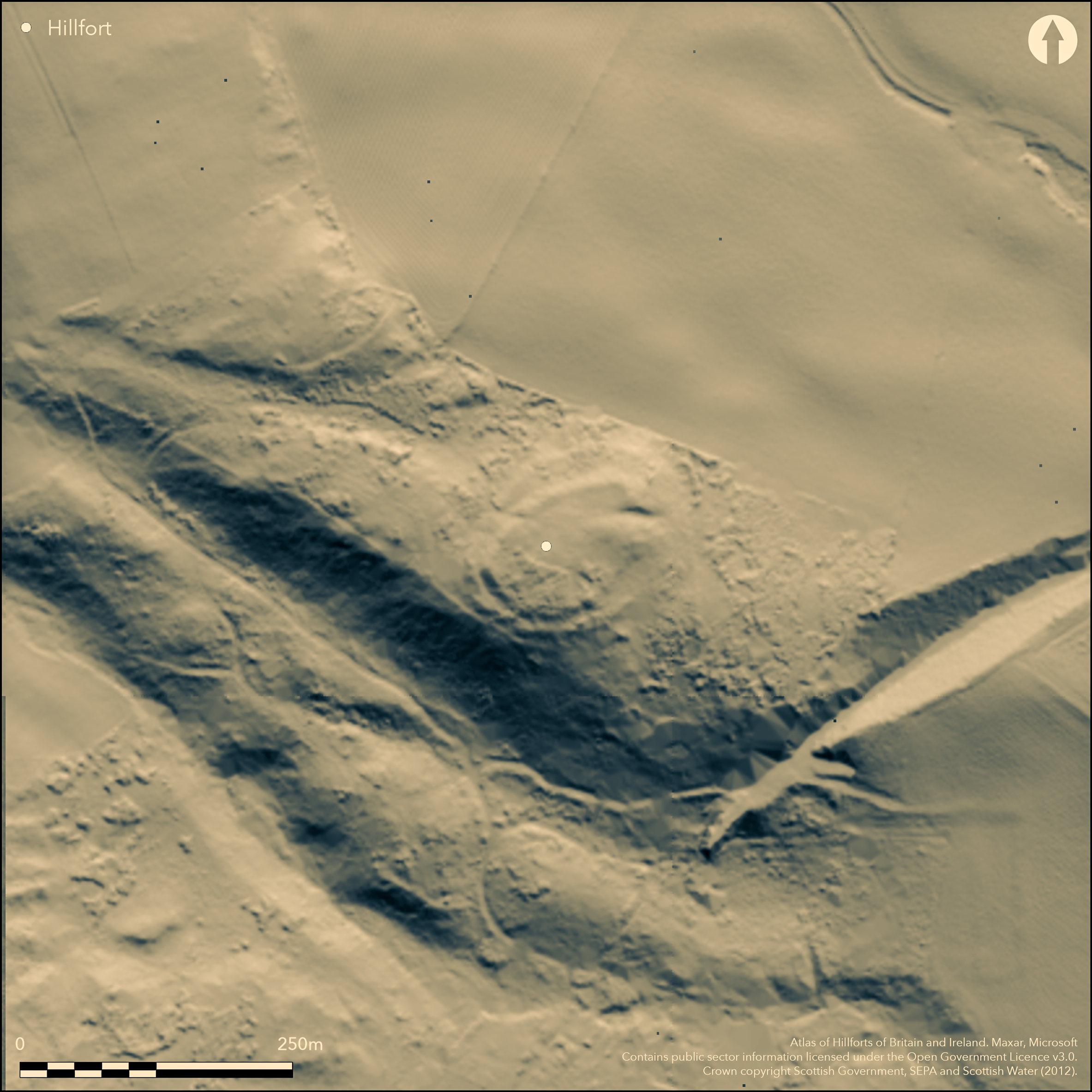
LiDAR 1m DTM Hillshade

Satellite Imagery
LiDAR 1m DTM Hillshade
Satellite Imagery
Scroll left/right to view further images.
HER: Dumfries & Galloway MDG6184 (None)
NMR: NX 97 SW 10 (65730)
SM: None
NGR: NX 9302 7385
X: 293020 Y: 573850 (OSGB36)
This fort occupies the hillock forming the SE end of the ridge clothed by Goldielea Wood, where the ground falls away steeply into a deep gully on the W and in shorter slopes elsewhere. Roughly oval on plan, it measures 81m from NE to SW by 57m transversely (0.36ha) within two ramparts, which are not strictly concentric, ranging up to a maximum of 10m apart. For the greater part of the circuit they have been reduced to scarps, and on the NE the line of the outer is uncertain on account of a shallow hollow in the flank of the hillock which may be the remains of a quarry, but where they are best preserved facing onto the shallow saddle in the crest of the ridge on the N they are also accompanied by external ditches. Here the inner rampart forms a bank 4m in thickness, standing about 0.8m in height above the interior, but falling 3m externally into the bottom of the ditch. The outer rampart below it is no more than a scarp, but there are traces of a counterscarp bank on the outer lip of its ditch. The entrance is on the E, where a deep hollow pierces both ramparts, albeit that the outer is no more than the faintest of crest-lines to either side of the gap. This hollow seems to be an original feature of the entrance, cutting down some 3m below the crest of the inner rampart and creating an evenly graded ramp leading up into the featureless interior; at its lower end a later boundary bank cuts across its line. This is almost certainly the fort known in the district in the 19th century as Tregallon Mote, but remained hidden in the dense undergrowth in the plantation that plainly existed when Frederick Coles recorded some miscellaneous features on the adjacent hillock to the N (1893).
Citizen Science: ✗
Reliability of Data: Confirmed
Reliability of Interpretation: Confirmed
X: -409207 Y: 7371114 (EPSG: 3857)
Longitude: -3.6759661967904407 Latitude: 55.047620607792965 (EPSG:4326)
Country: Scotland
Current County or Unitary Authority: Dumfries & Galloway
Historic County: Kirkcudbrightshire
Current Parish/Community/Council/Townland: Troqueer
None
| Extant | ✓ |
| Cropmark | ✗ |
| Likely Destroyed | ✗ |
None
| Woodland | ✓ |
| Commercial Forestry Plantation | ✗ |
| Parkland | ✗ |
| Pasture (Grazing) | ✗ |
| Arable | ✗ |
| Scrub/Bracken | ✗ |
| Bare Outcrop | ✗ |
| Heather/Moorland | ✗ |
| Heath | ✗ |
| Built-up | ✗ |
| Coastal Grassland | ✗ |
| Other | ✗ |
None
| Contour Fort | ✓ |
| Partial Contour Fort | ✗ |
| Promontory Fort | ✗ |
| Hillslope Fort | ✗ |
| Level Terrain Fort | ✗ |
| Marsh Fort | ✗ |
| Multiple Enclosure Fort | ✗ |
| Hilltop | ✓ |
| Coastal Promontory | ✗ |
| Inland Promontory | ✗ |
| Valley Bottom | ✗ |
| Knoll/Hillock/Outcrop | ✗ |
| Ridge | ✗ |
| Cliff/Plateau-edge/Scarp | ✗ |
| Hillslope | ✗ |
| Lowland | ✗ |
| Spur | ✗ |
Dominant Topographic Feature: None
| North | ✗ |
| Northeast | ✗ |
| East | ✗ |
| Southeast | ✗ |
| South | ✗ |
| Southwest | ✗ |
| West | ✗ |
| Northwest | ✗ |
| Level | ✓ |
Altitude: 90.0m
N/A
In the absence of excavation, there are neither stratified artefacts nor radiocarbon dates to provide a chronology for the defences.
Reliability: D - None
| Pre 1200BC | ✗ |
| 1200BC - 800BC | ✗ |
| 800BC - 400BC | ✗ |
| 400BC - AD50 | ✗ |
| AD50 - AD400 | ✗ |
| AD400 - AD 800 | ✗ |
| Post AD800 | ✗ |
| Unknown | ✓ |
| Pre Hillfort: | None |
| Post Hillfort: | None |
First discovered by J Williams and G Anderson (1971), it was not mapped by the OS at 1:2500 until 1973. This earthwork, however, was probably known in the locality as Tregallon Mote, but in 1892 Fred Coles seems to have misunderstood the directions he had been given, and in the dense undergrowth in the plantation ended up on the hillock to the N of the fort (1893, 120-1). That location appears as Tregallon Mote on the OS 25-inch map thereafter (Kirkcudbrightshire 1894, sheet 29.7), leading to a visit by Alexander Curle in 1912 during the preparation of the County Inventory for The Stewartry (RCAHMS 1914, 266, no.459). Not realising the initial mistake, In 1973 the OS visited the position shown on the map at the same time that they surveyed this fort, at which time it was still under dense vegetation. A field visit by SH and Peter Corser in 2014 concluded that while there was evidence of a bank along the S flank of the hillock named Tregallon Mote on the map, there was no reason to believe that it formed part of an enclosure, fortified or otherwise, and it has thus does not figure in the Hillfort Atlas
| 1st Identified Written Reference (1971): | Discovered (Williams and Anderson 1971) |
| 1st Identified Map Depiction (1973): | Surveyed 1:2500 |
| Other (2014): | Description by SH and Peter Corser |
Featureless
None
| None | ✓ |
| Spring | ✗ |
| Stream | ✗ |
| Pool | ✗ |
| Flush | ✗ |
| Well | ✗ |
| Other | ✗ |
None
| No Known Features | ✓ |
| Round Stone Structures | ✗ |
| Rectangular Stone Structures | ✗ |
| Curvilinear Platforms | ✗ |
| Other Roundhouse Evidence | ✗ |
| Pits | ✗ |
| Quarry Hollows | ✗ |
| Other | ✗ |
None
| No Known Excavation | ✓ |
| Pits | ✗ |
| Postholes | ✗ |
| Roundhouses | ✗ |
| Rectangular Structures | ✗ |
| Roads/Tracks | ✗ |
| Quarry Hollows | ✗ |
| Other | ✗ |
| Nothing Found | ✗ |
None
| No Known Geophysics | ✓ |
| Pits | ✗ |
| Roundhouses | ✗ |
| Rectangular Structures | ✗ |
| Roads/Tracks | ✗ |
| Quarry Hollows | ✗ |
| Other | ✗ |
| Nothing Found | ✗ |
None
| No Known Finds | ✓ |
| Pottery | ✗ |
| Metal | ✗ |
| Metalworking | ✗ |
| Human Bones | ✗ |
| Animal Bones | ✗ |
| Lithics | ✗ |
| Environmental | ✗ |
| Other | ✗ |
Under woodland
| APs Not Checked | ✗ |
| None | ✓ |
| Roundhouses | ✗ |
| Rectangular Structures | ✗ |
| Pits | ✗ |
| Postholes | ✗ |
| Roads/Tracks | ✗ |
| Other | ✗ |
See main summary
| 1: | None |
| 2: | None |
Guard Chambers: ✗
Chevaux de Frise: ✗
| 1. Simple Gap (North east): | With hollowed track |
twin ramparts and ditches
| Area 1: | 0.36ha. |
| Total: | 0.36ha. |
Total Footprint Area: Noneha.
None
| ✗ | None |
| ✓ | None |
| NE Quadrant: | 2 |
| SE Quadrant: | 2 |
| SW Quadrant: | 2 |
| NW Quadrant: | 2 |
| Total: | 2 |
| Partial Univallate | ✗ |
| Univallate | ✗ |
| Partial Bivallate | ✗ |
| Bivallate | ✓ |
| Partial Multivallate | ✗ |
| Multivallate | ✗ |
| Unknown | ✗ |
| Partial Univallate | ✗ |
| Univallate | ✗ |
| Partial Bivallate | ✗ |
| Bivallate | ✗ |
| Partial Multivallate | ✗ |
| Multivallate | ✗ |
None
| None | ✗ |
| Earthen Bank | ✓ |
| Stone Wall | ✗ |
| Rubble | ✗ |
| Wall-walk | ✗ |
| Evidence of Timber | ✗ |
| Vitrification | ✗ |
| Other Burning | ✗ |
| Palisade | ✗ |
| Counter Scarp Bank | ✓ |
| Berm | ✗ |
| Unfinished | ✗ |
| Other | ✗ |
None
| None | ✗ |
| Earthen Bank | ✗ |
| Stone Wall | ✗ |
| Murus Duplex | ✗ |
| Timber-framed | ✗ |
| Timber-laced | ✗ |
| Vitrification | ✗ |
| Other Burning | ✗ |
| Palisade | ✗ |
| Counter Scarp Bank | ✗ |
| Berm | ✗ |
| Unfinished | ✗ |
| No Known Excavation | ✓ |
| Other | ✗ |
| ✗ | None |
| ✓ | None |
Number of Ditches: 2
| ✗ | None |
Coles, F R (1893) 'The motes, forts, and doons in the east and west divisions of the Stewartry of Kirkcudbright', Proc Soc Antiq Scot 27, 92-182
RCAHMS (1914) The Royal Commission on the Ancient and Historical Monuments and Constructions of Scotland. Fifth report and Inventory of Monuments and Constructions in Galloway, II, County of the Stewartry of Kirkcudbright, Edinburgh
Williams, J and Anderson, G (1971) 'Troqueer, Goldielea/Tregallon, Iron Age sites', Disc Exc Scot 1971, 26
Atlas of Hillforts:
Wikidata:
This work is licensed under CC BY-SA 4.0![]()
![]()
![]() and should be cited as:
and should be cited as:
Lock, Gary and Ralston, Ian. 2024. Atlas of Hillforts of Britain and Ireland. Available at: https://hillforts.arch.ox.ac.uk
Document Version 1.1