LiDAR 1m DTM Hillshade
Satellite Imagery
LiDAR 1m DTM Hillshade
Satellite Imagery
Scroll left/right to view further images.
HER: Dumfries & Galloway MDG5560 (None)
NMR: NX 88 SE 1 (65116)
SM: 662
NGR: NX 8944 8431
X: 289440 Y: 584310 (OSGB36)
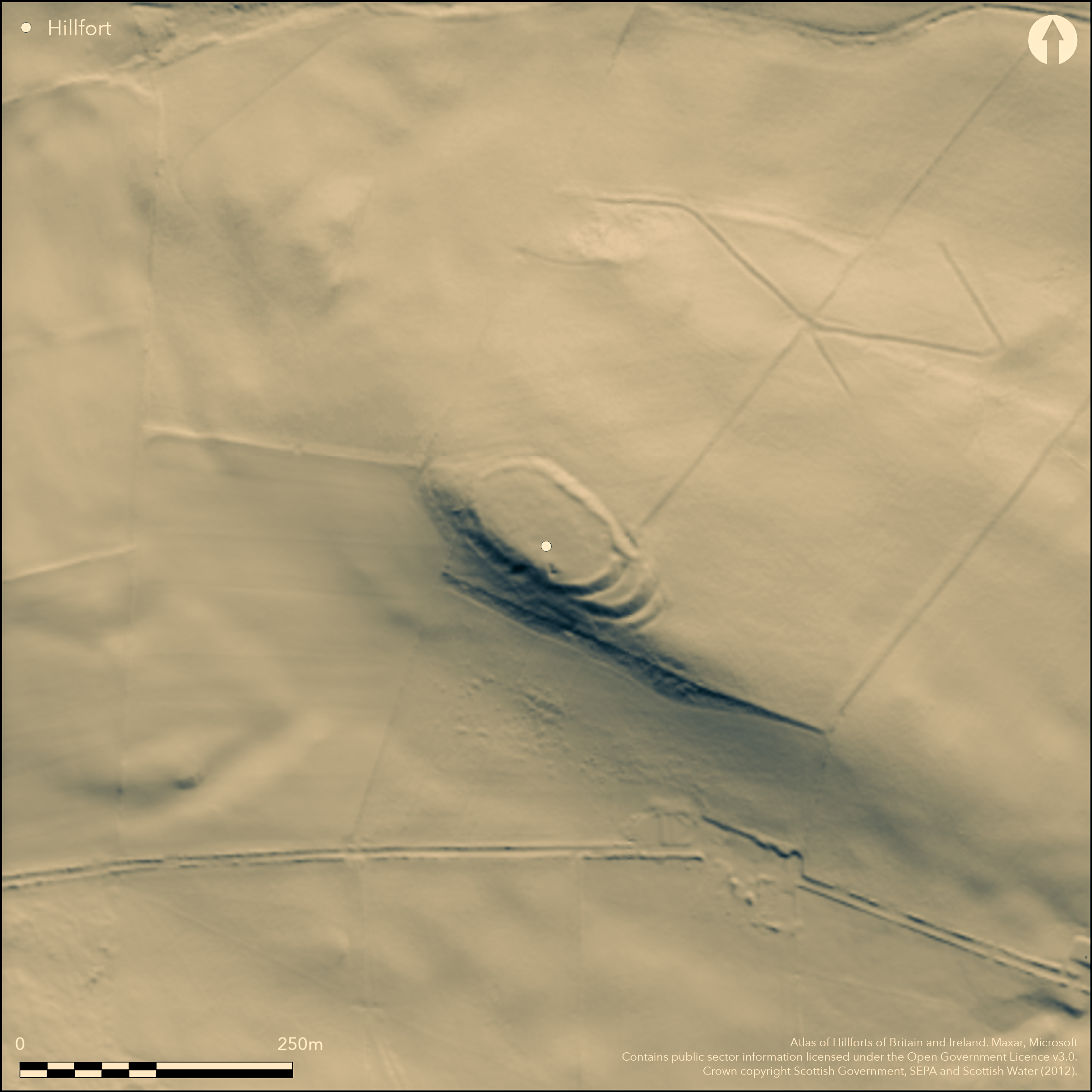
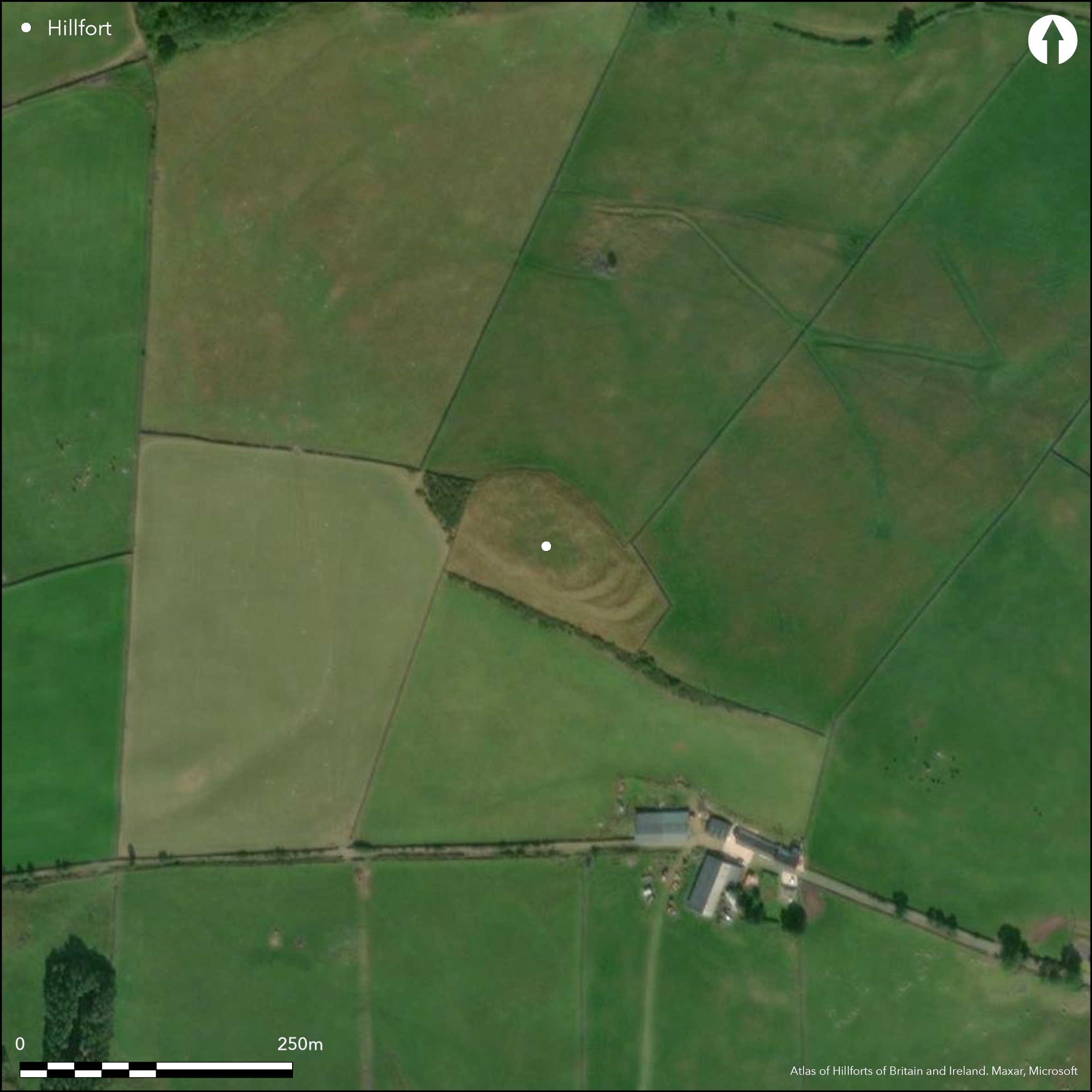
Situated on a commanding hilltop, this oval fort measures internally 78m from NW to SE by 44m transversely (0.28ha) and is enclosed on all sides except the steep SW flank by a rampart standing up to 1.5m high internally and 3m above the bottom of an external ditch. The entrance is on the E, close to the SE end and seems to have been protected with outworks, though these survive only on the SW side of the gap, Comprising two ramparts standing up to 3m above the bottoms of external ditches, these loop out from the point where the ditch accompanying the innermost rampart seems to peter out on the steep SW flank of the hill. Within the interior there traces of a palisade trench placed eccentrically within the inner rampart to enclose an area measuring about 65m from NW to SE by 35m transversely. Apart from traces of the larch plantation with which the fort was planted in the 19th century, the interior is otherwise featureless.
Citizen Science: ✓
Reliability of Data: Confirmed
Reliability of Interpretation: Confirmed
X: -415894 Y: 7389238 (EPSG: 3857)
Longitude: -3.7360389877486706 Latitude: 55.14078913512098 (EPSG:4326)
Country: Scotland
Current County or Unitary Authority: Dumfries & Galloway
Historic County: Dumfriesshire
Current Parish/Community/Council/Townland: Dunscore
None
| Extant | ✓ |
| Cropmark | ✗ |
| Likely Destroyed | ✗ |
Was under trees during the 19th century
| Woodland | ✗ |
| Commercial Forestry Plantation | ✗ |
| Parkland | ✗ |
| Pasture (Grazing) | ✓ |
| Arable | ✗ |
| Scrub/Bracken | ✗ |
| Bare Outcrop | ✗ |
| Heather/Moorland | ✗ |
| Heath | ✗ |
| Built-up | ✗ |
| Coastal Grassland | ✗ |
| Other | ✗ |
None
| Contour Fort | ✓ |
| Partial Contour Fort | ✗ |
| Promontory Fort | ✗ |
| Hillslope Fort | ✗ |
| Level Terrain Fort | ✗ |
| Marsh Fort | ✗ |
| Multiple Enclosure Fort | ✗ |
| Hilltop | ✓ |
| Coastal Promontory | ✗ |
| Inland Promontory | ✗ |
| Valley Bottom | ✗ |
| Knoll/Hillock/Outcrop | ✗ |
| Ridge | ✗ |
| Cliff/Plateau-edge/Scarp | ✗ |
| Hillslope | ✗ |
| Lowland | ✗ |
| Spur | ✗ |
Dominant Topographic Feature: None
| North | ✗ |
| Northeast | ✗ |
| East | ✗ |
| Southeast | ✗ |
| South | ✗ |
| Southwest | ✗ |
| West | ✗ |
| Northwest | ✗ |
| Level | ✓ |
Altitude: 196.0m
N/A
In the absence of excavation, there are neither stratified artefacts nor radiocarbon dates to provide a chronology for the defences.
Reliability: D - None
| Pre 1200BC | ✗ |
| 1200BC - 800BC | ✗ |
| 800BC - 400BC | ✗ |
| 400BC - AD50 | ✗ |
| AD50 - AD400 | ✗ |
| AD400 - AD 800 | ✗ |
| Post AD800 | ✗ |
| Unknown | ✓ |
| Pre Hillfort: | A bronze flanged axe and a spearhead have been found on separate occasions either within or close to the fort |
| Post Hillfort: | Planted with trees during the 19th century |
First noted about 1835 by the minster of Dunscore, at which time it was newly planted with larch saplings (NSA, 4, Dumfriesshire, 339), the fort was depicted about 1855 on the OS 25-inch map (Dumfriesshire 1861, sheet 40.15) and visited in 1913 by Alexander Curle during the preparation of the County Inventory for Dumfriesshire (RCAHMS 1920, 57, no.141). It was re-surveyed by the OS at 1:2500 in 1973, and photographed by the RCAHMS Aerial Survey Programme in 2000, at which time the palisade trench was recognised within the interior.
| 1st Identified Written Reference (1835): | Description (NSA, 4, Dumfriesshire, 339) |
| 1st Identified Map Depiction (1855): | Annotated Camp in Roman type on the OS 25-inch map (Dumfriesshire 1861, sheet 40.15) |
| Other (1913): | Description (RCAHMS 1920, 57, no.141) |
| Other (1937): | Scheduled |
| Other (1973): | Resurveyed at 1:2500 by the OS |
| Other (2000): | Palisade recognised (RCAHMS Aerial Survey Programme) |
Featureless apart from the palisade trench, though possibly on account of having been a plantation.
None
| None | ✓ |
| Spring | ✗ |
| Stream | ✗ |
| Pool | ✗ |
| Flush | ✗ |
| Well | ✗ |
| Other | ✗ |
None
| No Known Features | ✓ |
| Round Stone Structures | ✗ |
| Rectangular Stone Structures | ✗ |
| Curvilinear Platforms | ✗ |
| Other Roundhouse Evidence | ✗ |
| Pits | ✗ |
| Quarry Hollows | ✗ |
| Other | ✗ |
None
| No Known Excavation | ✓ |
| Pits | ✗ |
| Postholes | ✗ |
| Roundhouses | ✗ |
| Rectangular Structures | ✗ |
| Roads/Tracks | ✗ |
| Quarry Hollows | ✗ |
| Other | ✗ |
| Nothing Found | ✗ |
None
| No Known Geophysics | ✓ |
| Pits | ✗ |
| Roundhouses | ✗ |
| Rectangular Structures | ✗ |
| Roads/Tracks | ✗ |
| Quarry Hollows | ✗ |
| Other | ✗ |
| Nothing Found | ✗ |
In 1909 and 1865 respectively a bronze flanged axe and Late Bronze Age spearhead are said to have been found in or near the fort.
| No Known Finds | ✗ |
| Pottery | ✗ |
| Metal | ✓ |
| Metalworking | ✗ |
| Human Bones | ✗ |
| Animal Bones | ✗ |
| Lithics | ✗ |
| Environmental | ✗ |
| Other | ✗ |
None
| APs Not Checked | ✗ |
| None | ✓ |
| Roundhouses | ✗ |
| Rectangular Structures | ✗ |
| Pits | ✗ |
| Postholes | ✗ |
| Roads/Tracks | ✗ |
| Other | ✗ |
See main summary
| 1: | None |
| 2: | None |
Guard Chambers: ✗
Chevaux de Frise: ✗
| 1. Simple Gap (East): | None |
Single rampart and ditch around most of the hilltop, and there are additional outworks around the entrance on the E
| Area 1: | 0.28ha. |
| Total: | 0.28ha. |
Total Footprint Area: Noneha.
None
| ✗ | Overall footprint may be more extensive than the visible remains |
| ✗ | None |
| NE Quadrant: | 1 |
| SE Quadrant: | 3 |
| SW Quadrant: | 0 |
| NW Quadrant: | 1 |
| Total: | 3 |
| Partial Univallate | ✓ |
| Univallate | ✗ |
| Partial Bivallate | ✗ |
| Bivallate | ✗ |
| Partial Multivallate | ✓ |
| Multivallate | ✗ |
| Unknown | ✗ |
| Partial Univallate | ✗ |
| Univallate | ✗ |
| Partial Bivallate | ✗ |
| Bivallate | ✗ |
| Partial Multivallate | ✗ |
| Multivallate | ✗ |
None
| None | ✗ |
| Earthen Bank | ✓ |
| Stone Wall | ✗ |
| Rubble | ✗ |
| Wall-walk | ✗ |
| Evidence of Timber | ✗ |
| Vitrification | ✗ |
| Other Burning | ✗ |
| Palisade | ✓ |
| Counter Scarp Bank | ✗ |
| Berm | ✗ |
| Unfinished | ✗ |
| Other | ✗ |
None
| None | ✗ |
| Earthen Bank | ✗ |
| Stone Wall | ✗ |
| Murus Duplex | ✗ |
| Timber-framed | ✗ |
| Timber-laced | ✗ |
| Vitrification | ✗ |
| Other Burning | ✗ |
| Palisade | ✗ |
| Counter Scarp Bank | ✗ |
| Berm | ✗ |
| Unfinished | ✗ |
| No Known Excavation | ✓ |
| Other | ✗ |
| ✗ | None |
| ✓ | one principal circuit with another two outer ditches at the entrance. |
Number of Ditches: 3
| ✗ | None |
Coles, J M (1964) 'Scottish Middle Bronze Age metalwork'. Proc Soc Antiq Scot 97, 82-156
Coles, J M (1960) 'Scottish Late Bronze Age Metalwork: Typology, Distribution and Chronology'. Proc Soc Antiq Scot 93, 16-134
Corrie, J M (1926) 'Notice of (1) certain bronze implements from Dumfriesshire; and (2) a symbol stone from East Lomond Hill, Fife, recently presented to the National Museum', Proc Soc Antiq Scot 60, 27-34
NSA (1834-1845) The new statistical account of Scotland by the ministers of the respective parishes under the superintendence of a committee of the society for the benefit of the sons and daughters of the clergy, 15v Edinburgh
RCAHMS (1920) The Royal Commission on the Ancient and Historical Monuments and Constructions of Scotland. Seventh report with inventory of monuments and constructions in the county of Dumfries, Edinburgh
Atlas of Hillforts:
Wikidata:
This work is licensed under CC BY-SA 4.0![]()
![]()
![]() and should be cited as:
and should be cited as:
Lock, Gary and Ralston, Ian. 2024. Atlas of Hillforts of Britain and Ireland. Available at: https://hillforts.arch.ox.ac.uk
Document Version 1.1