Satellite Imagery
Satellite Imagery
HER: Dumfries & Galloway MDG5829 (None)
NMR: NX 95 NE 4 (65369)
SM: 1083
NGR: NX 9962 5769
X: 299620 Y: 557690 (OSGB36)
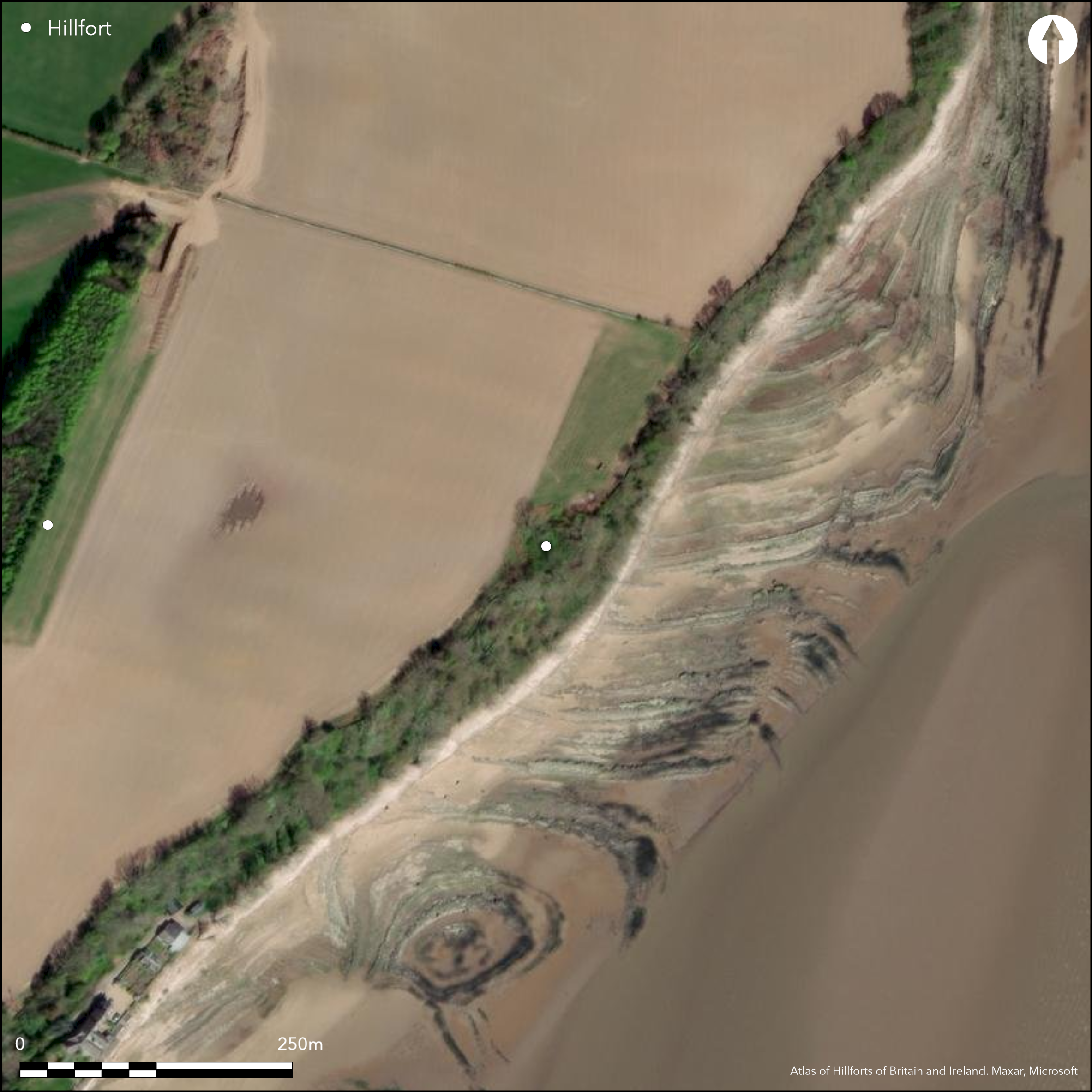
This tiny fortification, which backs onto the coastal cliffs at Arbigland, was excavated by General J Scott-Elliott over two seasons 1962-3 (Scott-Elliott 1963). Roughly semi-circular on plan, the interior measures about 20m from NE to SW along the cliff-edge by a maximum of 15m transversely (0.03ha). Although the rampart does not seem to have extended along the cliff-edge, this side may have been closed off by a palisade, traces of which were uncovered dismounting from the southern terminal of the rampart, where there was thought to have been an entrance. Elsewhere the rampart forms a bank up to 4m in thickness by 1.3m in height, and is fronted by a massive external ditch some 10m in breadth, which in excavation in the central sector proved to have a flat bottom at a depth of about 3m, though at its ends on the cliff-edge it displayed a V-shaped profile. The leading edge of the rampart was probably revetted with stonework, and a later wall had been built on its crest, perhaps when the interior was incorporated into the gardens of Arbigland House in the late 19th century. A scatter of post-holes and pits was found in the interior, and finds from a hearth close to the NE terminal of the rampart included a sherd of Samian Ware of 2nd century date.
Citizen Science: ✗
Reliability of Data: Confirmed
Reliability of Interpretation: Confirmed
X: -397082 Y: 7343224 (EPSG: 3857)
Longitude: -3.567044502003705 Latitude: 54.903833288014646 (EPSG:4326)
Country: Scotland
Current County or Unitary Authority: Dumfries & Galloway
Historic County: Kirkcudbrightshire
Current Parish/Community/Council/Townland: Kirkbean
None
| Extant | ✓ |
| Cropmark | ✗ |
| Likely Destroyed | ✗ |
None
| Woodland | ✓ |
| Commercial Forestry Plantation | ✗ |
| Parkland | ✗ |
| Pasture (Grazing) | ✗ |
| Arable | ✗ |
| Scrub/Bracken | ✗ |
| Bare Outcrop | ✗ |
| Heather/Moorland | ✗ |
| Heath | ✗ |
| Built-up | ✗ |
| Coastal Grassland | ✗ |
| Other | ✗ |
None
| Contour Fort | ✗ |
| Partial Contour Fort | ✗ |
| Promontory Fort | ✓ |
| Hillslope Fort | ✗ |
| Level Terrain Fort | ✗ |
| Marsh Fort | ✗ |
| Multiple Enclosure Fort | ✗ |
| Hilltop | ✗ |
| Coastal Promontory | ✓ |
| Inland Promontory | ✗ |
| Valley Bottom | ✗ |
| Knoll/Hillock/Outcrop | ✗ |
| Ridge | ✗ |
| Cliff/Plateau-edge/Scarp | ✓ |
| Hillslope | ✗ |
| Lowland | ✗ |
| Spur | ✗ |
Dominant Topographic Feature: None
| North | ✗ |
| Northeast | ✗ |
| East | ✗ |
| Southeast | ✗ |
| South | ✗ |
| Southwest | ✗ |
| West | ✗ |
| Northwest | ✗ |
| Level | ✓ |
Altitude: 20.0m
N/A
While finds from a hearth include a sherd of Samian of 2nd century date, this does not necessarily date the construction of the earthwork itself.
Reliability: C - Low
| Pre 1200BC | ✗ |
| 1200BC - 800BC | ✗ |
| 800BC - 400BC | ✗ |
| 400BC - AD50 | ✗ |
| AD50 - AD400 | ✓ |
| AD400 - AD 800 | ✗ |
| Post AD800 | ✗ |
| Unknown | ✓ |
| Pre Hillfort: | None |
| Post Hillfort: | Utilised as a garden |
| Artefactual: | None |
Though apparently shown as hedged enclosure on Roy's map (1747-55), and annotated 'McCullochs Cast.' on John Ainslie's map of the Stewartry (1797), it is first depicted in any detail on the 1st edition OS 6-inch map in 1851 (Kirkcudbrightshire 1854, sheet 47). It was subsequently described by Frederick Coles about 1892 with the aid of measured profiles (Coles 1893, 124, fig 25). In 1911 it was planned, either by Fred Macgibbon or Patrick Watson, during the preparation of the County Inventory for The Stewartry (RCAHMS 1914, 106-7, fig 73). It was revisited by Kenneth Steer of RCAHMS in 1951, when despite the impenetrable brambles he concluded that it was probably a dun. Subsequently excavations in 1962-3 by General James Scott-Elliot with the assistance of Dr Ian Rae (Scott-Elliot 1963) made clear that it was not a stone-walled dun. The OS re-surveyed the earthworks at 1:2500 in 1965.
| 1st Identified Map Depiction (1755): | Roy's Map (1747-55) |
| Other (1851): | Named in Gothic type on the 1st edition OS 6-inch map (Kirkcudbrightshire 1854, sheet 47) |
| Earthwork Survey (1892): | Profiles and description (Coles 1893, 124, fig 25) |
| Earthwork Survey (1911): | Plan by Fred Macgibbon or Patrick Watson (RCAHMS 1914, 106-7, fig 73) |
| Other (1938): | Scheduled |
| Other (1951): | Description during RCAHMS Survey of Marginal Lands |
| Excavation (1962): | in two seasons in 1962-3 (Scott-Elliot 1963) |
| Excavation (1963): | in two seasons in 1962-3 (Scott-Elliot 1963) |
| Other (1965): | Resurveyed at 1:2500 by the OS |
Scatter of pit and postholes in no discernable pattern, and a single hearth
None
| None | ✓ |
| Spring | ✗ |
| Stream | ✗ |
| Pool | ✗ |
| Flush | ✗ |
| Well | ✗ |
| Other | ✗ |
None
| No Known Features | ✓ |
| Round Stone Structures | ✗ |
| Rectangular Stone Structures | ✗ |
| Curvilinear Platforms | ✗ |
| Other Roundhouse Evidence | ✗ |
| Pits | ✗ |
| Quarry Hollows | ✗ |
| Other | ✗ |
Hearth
| No Known Excavation | ✗ |
| Pits | ✓ |
| Postholes | ✓ |
| Roundhouses | ✗ |
| Rectangular Structures | ✗ |
| Roads/Tracks | ✗ |
| Quarry Hollows | ✗ |
| Other | ✓ |
| Nothing Found | ✗ |
None
| No Known Geophysics | ✓ |
| Pits | ✗ |
| Roundhouses | ✗ |
| Rectangular Structures | ✗ |
| Roads/Tracks | ✗ |
| Quarry Hollows | ✗ |
| Other | ✗ |
| Nothing Found | ✗ |
In addition to the sherd of Samian Ware, finds from the hearth include several other sherds of possibly Roman pottery, an iron bar, three pieces of hematite, a stone palette, a whetstone, a pice of flint and a piece of jet.
| No Known Finds | ✗ |
| Pottery | ✓ |
| Metal | ✓ |
| Metalworking | ✗ |
| Human Bones | ✗ |
| Animal Bones | ✗ |
| Lithics | ✓ |
| Environmental | ✗ |
| Other | ✗ |
None
| APs Not Checked | ✗ |
| None | ✓ |
| Roundhouses | ✗ |
| Rectangular Structures | ✗ |
| Pits | ✗ |
| Postholes | ✗ |
| Roads/Tracks | ✗ |
| Other | ✗ |
See main summary
| 0: | None |
| 2: | Thought to be on the S, but not clearly defined |
Guard Chambers: ✗
Chevaux de Frise: ✗
Single rampart with ditch
| Area 1: | 0.15ha. |
| Total: | 0.15ha. |
Total Footprint Area: Noneha.
None
| ✗ | None |
| ✗ | None |
| NE Quadrant: | 1 |
| SE Quadrant: | 0 |
| SW Quadrant: | 1 |
| NW Quadrant: | 1 |
| Total: | 1 |
| Partial Univallate | ✓ |
| Univallate | ✗ |
| Partial Bivallate | ✗ |
| Bivallate | ✗ |
| Partial Multivallate | ✗ |
| Multivallate | ✗ |
| Unknown | ✗ |
| Partial Univallate | ✗ |
| Univallate | ✗ |
| Partial Bivallate | ✗ |
| Bivallate | ✗ |
| Partial Multivallate | ✗ |
| Multivallate | ✗ |
None
| None | ✗ |
| Earthen Bank | ✓ |
| Stone Wall | ✗ |
| Rubble | ✗ |
| Wall-walk | ✗ |
| Evidence of Timber | ✗ |
| Vitrification | ✗ |
| Other Burning | ✗ |
| Palisade | ✗ |
| Counter Scarp Bank | ✗ |
| Berm | ✗ |
| Unfinished | ✗ |
| Other | ✗ |
Ditch
| None | ✗ |
| Earthen Bank | ✓ |
| Stone Wall | ✗ |
| Murus Duplex | ✗ |
| Timber-framed | ✗ |
| Timber-laced | ✗ |
| Vitrification | ✗ |
| Other Burning | ✗ |
| Palisade | ✓ |
| Counter Scarp Bank | ✗ |
| Berm | ✗ |
| Unfinished | ✗ |
| No Known Excavation | ✗ |
| Other | ✓ |
| ✗ | None |
| ✓ | None |
Number of Ditches: 1
| ✗ | None |
Coles, F R (1893) 'The motes, forts, and doons in the east and west divisions of the Stewartry of Kirkcudbright', Proc Soc Antiq Scot 27, 92-182
RCAHMS (1914) The Royal Commission on the Ancient and Historical Monuments and Constructions of Scotland. Fifth report and inventory of monuments and constructions in Galloway, II, county of the Stewartry of Kirkcudbright, Edinburgh.
Scott-Elliot, J (1963) 'McCulloch's Castle, Arbigland', Trans Dumfriesshire Galloway Natur Hist Antiq Soc 3 Ser, 41
Page(s): 118-24
Atlas of Hillforts:
Wikidata:
This work is licensed under CC BY-SA 4.0![]()
![]()
![]() and should be cited as:
and should be cited as:
Lock, Gary and Ralston, Ian. 2024. Atlas of Hillforts of Britain and Ireland. Available at: https://hillforts.arch.ox.ac.uk
Document Version 1.1