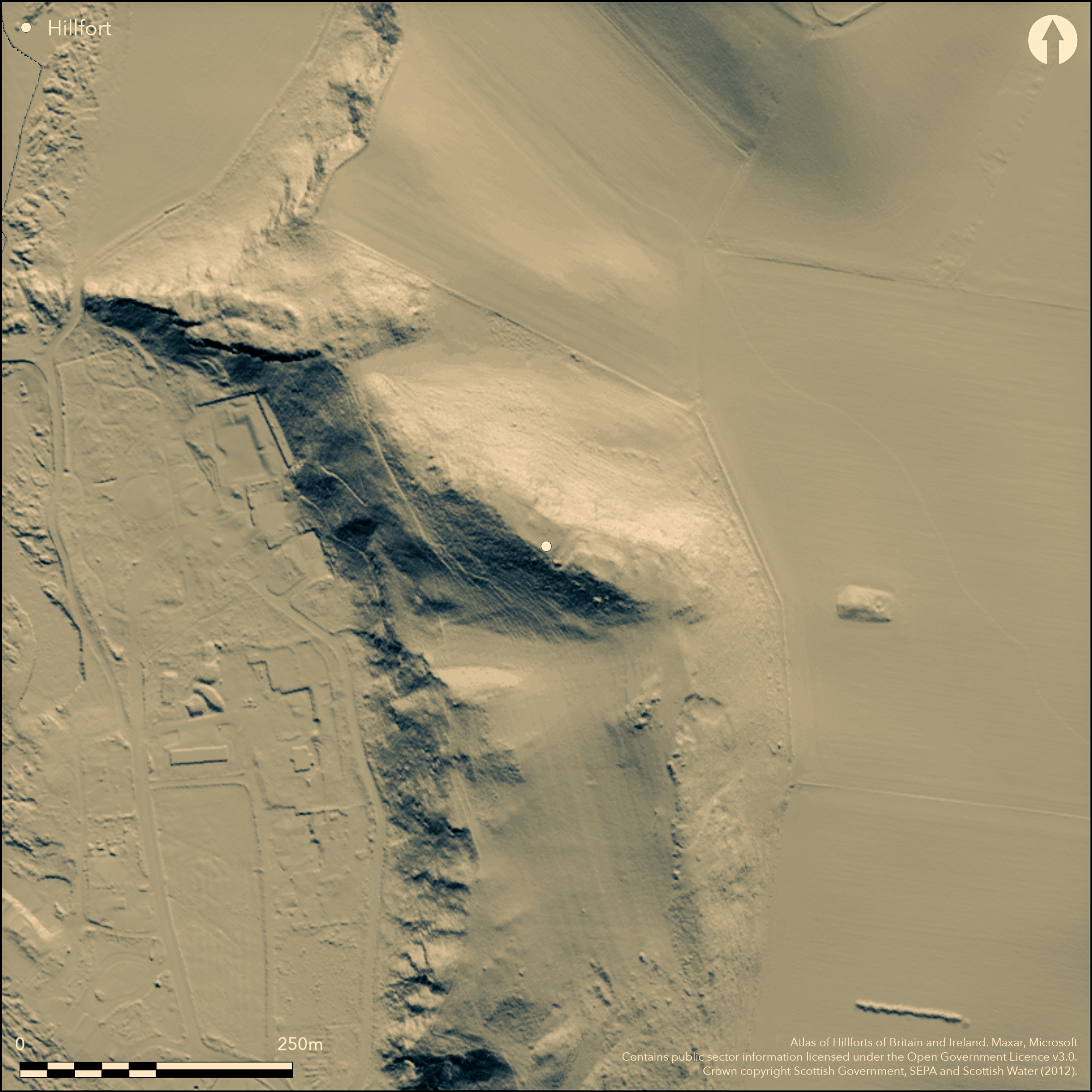
LiDAR 1m DTM Hillshade
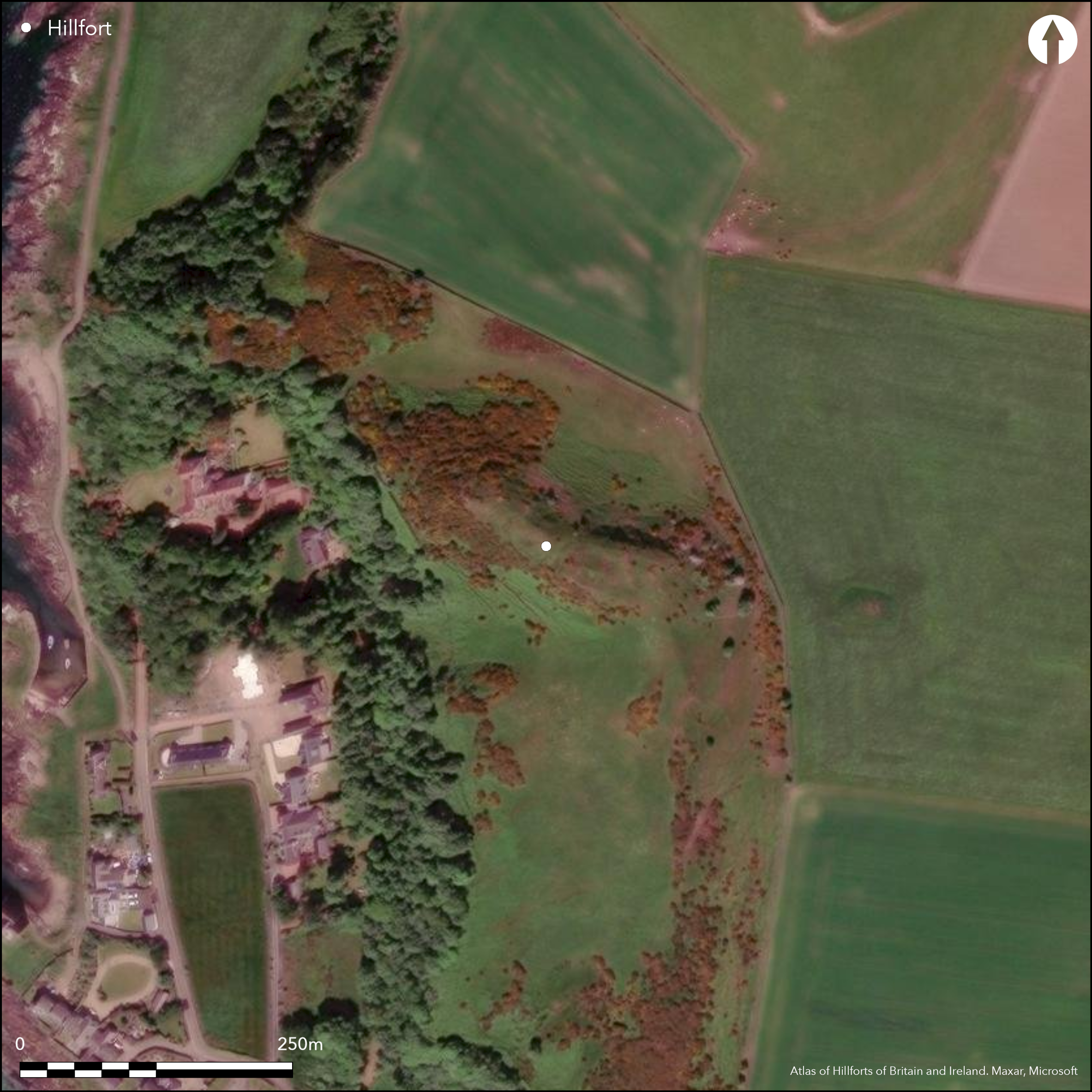
Satellite Imagery
LiDAR 1m DTM Hillshade
Satellite Imagery
Scroll left/right to view further images.
HER: The West of Scotland Archaeology Service 5165 (None)
NMR: NS 14 NE 1 (40587)
SM: 2175
NGR: NS 1783 4910
X: 217830 Y: 649100 (OSGB36)
This fort is situated on the elongated crest of Auld Hill above Portencross, a naturally strong position that was utilised in the medieval period for the successive construction of motte and bailey and stone castles. The defences of the earlier fort comprise a single vitrified rampart, traces of which can be seen in places along the margins of the hill and probably enclosed an area measuring about 110m from NW to SE by up to 28m transversely (0.28ha), though nothing of it can be seen around the NW end and its exact course on the SE is also uncertain. In 1987 the rampart was sectioned as part of a wider programme of excavation on the castle. It was about 3m in thickness, with both vitrified and fire-reddened stones in Çlaid rafts of packed dry stonework with each raft terraced into a level platform cut into the bedrock' (Caldwell et al 1998, 25). Though the rampart was sampled for TL dating, the fort is effectively undated. Nevertheless, part of an antler cheek-piece from horse harness found in a pit in the interior dates from the 7th-8th centuries BC, and a possible cooking-pit filled with burnt stones was also found beneath the medieval deposits. While the excavators speculate that the cheek-piece derives from the occupation of the fort, they also found what may be another early line of defence, a ditch some 2m in breadth by 1m in depth, cutting across the interior of the fort beneath the castle. Its stony fill was thought to have slipped from a drystone rampart enclosing the rocky boss forming the highest part of the interior, and now completely obscured by the remains of the castle. This they suggest might provide a context for the occupation material containing worked shale from the 7th-10th centuries AD, and indeed for the stray find of a bronze enamelled trumpet brooch of 1st-2nd century AD date on the flank of the hill.
Citizen Science: ✓
Reliability of Data: Confirmed
Reliability of Interpretation: Confirmed
X: -545526 Y: 7499137 (EPSG: 3857)
Longitude: -4.900546863020358 Latitude: 55.7010768758485 (EPSG:4326)
Country: Scotland
Current County or Unitary Authority: North Ayrshire
Historic County: Ayrshire
Current Parish/Community/Council/Townland: West Kilbride
None
| Extant | ✓ |
| Cropmark | ✗ |
| Likely Destroyed | ✗ |
Gorse thickets in places.
| Woodland | ✗ |
| Commercial Forestry Plantation | ✗ |
| Parkland | ✗ |
| Pasture (Grazing) | ✓ |
| Arable | ✗ |
| Scrub/Bracken | ✓ |
| Bare Outcrop | ✗ |
| Heather/Moorland | ✗ |
| Heath | ✗ |
| Built-up | ✗ |
| Coastal Grassland | ✗ |
| Other | ✗ |
None
| Contour Fort | ✓ |
| Partial Contour Fort | ✗ |
| Promontory Fort | ✗ |
| Hillslope Fort | ✗ |
| Level Terrain Fort | ✗ |
| Marsh Fort | ✗ |
| Multiple Enclosure Fort | ✗ |
| Hilltop | ✓ |
| Coastal Promontory | ✗ |
| Inland Promontory | ✗ |
| Valley Bottom | ✗ |
| Knoll/Hillock/Outcrop | ✗ |
| Ridge | ✗ |
| Cliff/Plateau-edge/Scarp | ✗ |
| Hillslope | ✗ |
| Lowland | ✗ |
| Spur | ✗ |
Dominant Topographic Feature: None
| North | ✗ |
| Northeast | ✗ |
| East | ✗ |
| Southeast | ✗ |
| South | ✗ |
| Southwest | ✗ |
| West | ✗ |
| Northwest | ✗ |
| Level | ✓ |
Altitude: 65.0m
N/A
Ramparts undated, but finds from the interior indicate occupation at a wide range of dates.
Reliability: B - Medium
| Pre 1200BC | ✗ |
| 1200BC - 800BC | ✗ |
| 800BC - 400BC | ✓ |
| 400BC - AD50 | ✗ |
| AD50 - AD400 | ✓ |
| AD400 - AD 800 | ✓ |
| Post AD800 | ✓ |
| Unknown | ✗ |
| Pre Hillfort: | None |
| Post Hillfort: | None |
| Artefactual: | None |
First surveyed in 1855 on the 1st edition of the OS 6-inch map (Ayrshire 1858, sheet 15), this depiction shows only the castle earthworks upon the summit. It was described shortly after in 1862 by William Keddie, who first describes the vitrifaction. Visited by Gordon Childe and Angus Graham for the wartime emergency survey programme (1943, 39), it was revisited by RCAHMS in 1952, while the OS re-surveyed and revised the 1:2500 depiction in 1968 and 1982 respectively. The confusion about the exact nature of some of the visible remains was only resolved when the castle was excavated 1987-9 by Gordon Ewart (Caldwell et al 1998).
| 1st Identified Map Depiction (1855): | Annotated Fort on the 1st edition OS 6-inch map (Ayrshire 1858, sheet 15) |
| Other (1862): | Description (Keddie 1868, 249-51) |
| Other (1943): | Description by Angus Graham and Gordon Childe for RCAHMS wartime Emergency Surveys |
| Other (1952): | Description during RCAHMS Survey of Marginal Lands |
| Other (1968): | Resurveyed at 1:2500 by the OS |
| Other (1982): | Revised at 1:2500 by the OS |
| Other (1983): | Visited by the Hill-Fort Study Group |
| Excavation (1987): | Caldwell et al 1998 |
| Excavation (1988): | Caldwell et al 1998 |
| Excavation (1989): | Caldwell et al 1998 |
Featureless apart from the remains of the overlying medieval castle
None
| None | ✓ |
| Spring | ✗ |
| Stream | ✗ |
| Pool | ✗ |
| Flush | ✗ |
| Well | ✗ |
| Other | ✗ |
None
| No Known Features | ✓ |
| Round Stone Structures | ✗ |
| Rectangular Stone Structures | ✗ |
| Curvilinear Platforms | ✗ |
| Other Roundhouse Evidence | ✗ |
| Pits | ✗ |
| Quarry Hollows | ✗ |
| Other | ✗ |
None
| No Known Excavation | ✗ |
| Pits | ✓ |
| Postholes | ✓ |
| Roundhouses | ✗ |
| Rectangular Structures | ✗ |
| Roads/Tracks | ✗ |
| Quarry Hollows | ✗ |
| Other | ✗ |
| Nothing Found | ✗ |
None
| No Known Geophysics | ✓ |
| Pits | ✗ |
| Roundhouses | ✗ |
| Rectangular Structures | ✗ |
| Roads/Tracks | ✗ |
| Quarry Hollows | ✗ |
| Other | ✗ |
| Nothing Found | ✗ |
None
| No Known Finds | ✗ |
| Pottery | ✗ |
| Metal | ✓ |
| Metalworking | ✗ |
| Human Bones | ✗ |
| Animal Bones | ✓ |
| Lithics | ✗ |
| Environmental | ✗ |
| Other | ✗ |
NO APPARENT FEATURES
| APs Not Checked | ✗ |
| None | ✓ |
| Roundhouses | ✗ |
| Rectangular Structures | ✗ |
| Pits | ✗ |
| Postholes | ✗ |
| Roads/Tracks | ✗ |
| Other | ✗ |
See main summary
| 0: | Rampart only intermittently visible |
| 2: | None known |
Guard Chambers: ✗
Chevaux de Frise: ✗
Single vitrified rampart.
| Area 1: | 0.3ha. |
| Total: | 0.3ha. |
Total Footprint Area: Noneha.
None
| ✓ | None |
| ✓ | None |
| NE Quadrant: | 1 |
| SE Quadrant: | 1 |
| SW Quadrant: | 1 |
| NW Quadrant: | 1 |
| Total: | 1 |
| Partial Univallate | ✗ |
| Univallate | ✓ |
| Partial Bivallate | ✗ |
| Bivallate | ✗ |
| Partial Multivallate | ✗ |
| Multivallate | ✗ |
| Unknown | ✗ |
| Partial Univallate | ✗ |
| Univallate | ✗ |
| Partial Bivallate | ✗ |
| Bivallate | ✗ |
| Partial Multivallate | ✗ |
| Multivallate | ✗ |
None
| None | ✗ |
| Earthen Bank | ✗ |
| Stone Wall | ✗ |
| Rubble | ✓ |
| Wall-walk | ✗ |
| Evidence of Timber | ✗ |
| Vitrification | ✓ |
| Other Burning | ✗ |
| Palisade | ✗ |
| Counter Scarp Bank | ✗ |
| Berm | ✗ |
| Unfinished | ✗ |
| Other | ✗ |
Stone filled ditch elsewhere on summit may indicate a further tumbled wall.
| None | ✗ |
| Earthen Bank | ✗ |
| Stone Wall | ✓ |
| Murus Duplex | ✗ |
| Timber-framed | ✗ |
| Timber-laced | ✗ |
| Vitrification | ✓ |
| Other Burning | ✗ |
| Palisade | ✗ |
| Counter Scarp Bank | ✗ |
| Berm | ✗ |
| Unfinished | ✗ |
| No Known Excavation | ✗ |
| Other | ✗ |
| ✗ | None |
| ✓ | Ditch cutting across the interior possibly relating to a later defended enclosure on the summit of the hill |
Number of Ditches: 1
| ✗ | None |
Caldwell, Ewart and Triscott, D H, G and J (1998) 'Auldhill, Portencross', Archaeol J 155, 22-81.
Childe and Graham, V G and A (1943) 'Some notable prehistoric and medieval monuments recently examined by The Royal Commission on Ancient and Historical Monuments of Scotland', Proc Soc Antiq Scot 77 (1943), 31-49
Feachem, R (1963) A guide to prehistoric Scotland, London (p 109)
Keddie, W (1868) 'On the remains of a vitrified fort, or site, in the island of Cumbrae, with notes on the vitrified forts of Berigonium, Glen Nevis, Craig Phadrick, Portencross, and Bute. Trans Glasgow Archaeol Soc 1 (1867)
Strickertsson, Placido and Tate, K, F and J O (1988) 'Thermoluminescence dating of Scottish vitrified forts', Nuclear Tracks Radiation Measurements, 14, 317-20
Atlas of Hillforts:
Wikidata:
This work is licensed under CC BY-SA 4.0![]()
![]()
![]() and should be cited as:
and should be cited as:
Lock, Gary and Ralston, Ian. 2024. Atlas of Hillforts of Britain and Ireland. Available at: https://hillforts.arch.ox.ac.uk
Document Version 1.1