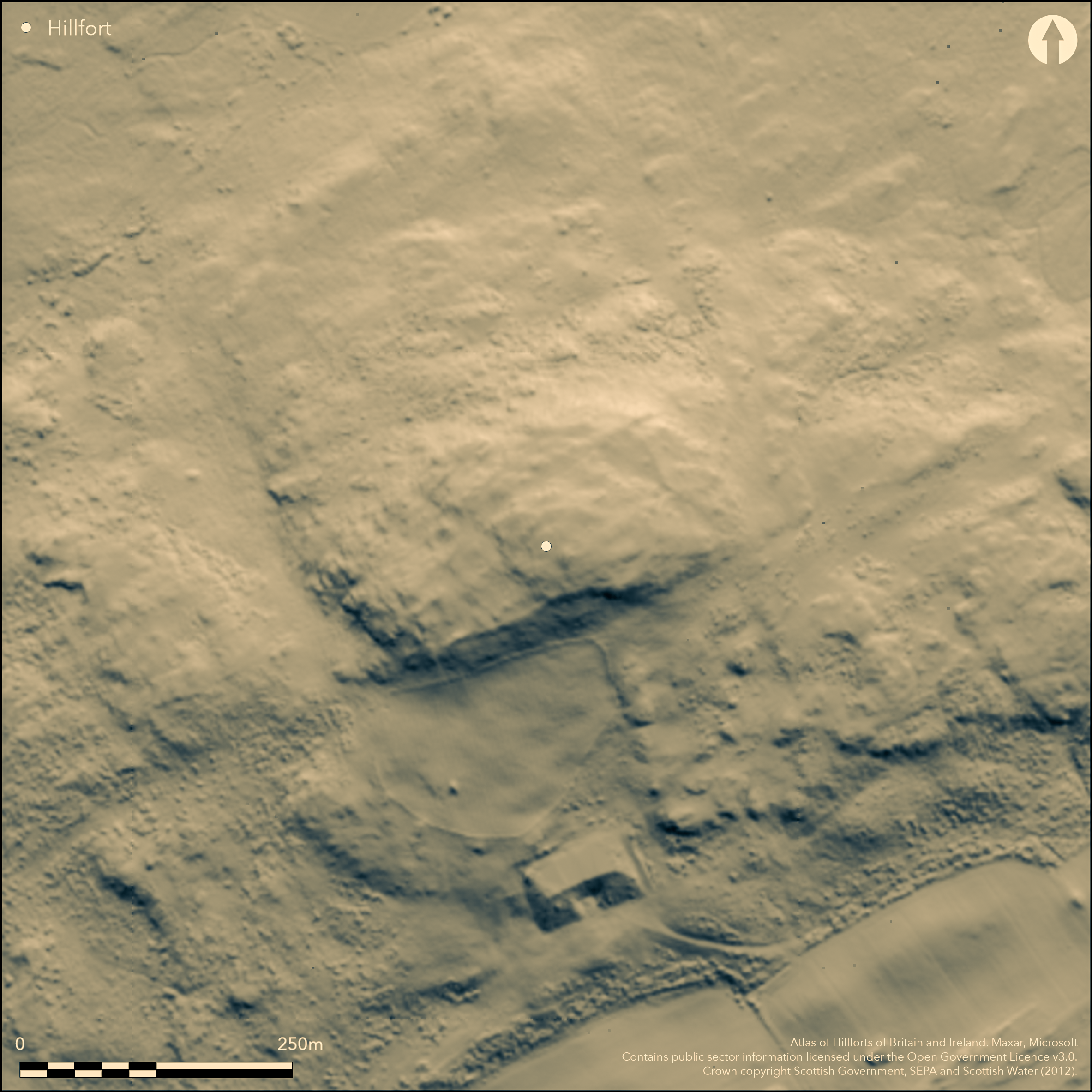
LiDAR 1m DTM Hillshade

Satellite Imagery
LiDAR 1m DTM Hillshade
Satellite Imagery
Scroll left/right to view further images.
HER: Dumfries & Galloway MDG2017 (None)
NMR: NX 25 NE 9 (62146)
SM: 1988
NGR: NX 2550 5577
X: 225500 Y: 555770 (OSGB36)
This fort is situated on Knock Fell, an isolated fort and relatively prominent hill in this part of The Machars. Pear-shaped on plan, it measures about 160m from ENE to WSW by a maximum of 85m transversely (1ha), tapering westwards where the line of the rampart follows a natural shoulder that descends from the highest part of the hill and forms a broad lower terrace. The rampart itself has been heavily robbed, but it still forms a massive scree of rubble up to 10m thick around the ENE end, where there are also traces of an outer rampart. Elsewhere the inner rampart is reduced to a stony scarp or, along the NW, little more than a scatter of stones. On this flank, however, there are again traces of an outer rampart, following a lower line some 20m down the slope, though in this case it is not clear at the point where the two converge whether they were conceived as part of a single scheme or whether the outer was once part of a larger enclosure of about 1.4ha on the hill top. A gap in the outcrops at the WSW end provides a sloping ramp leading into the interior and almost certainly marks the position of an entrance, but there may have been a second at the ENE end, where a hollowed trackway mounts the slope, passing through the outer rampart to reach a gap in the inner. Within the interior a rickle of stones can also bee seen extending across the spine of the hill below the summit on the W, and though it has been postulated as evidence of an earlier summit enclosure (RCAHMS 1914, 112, no.305) its date and purpose remain unknown. The interior is otherwise featureless.
Citizen Science: ✗
Reliability of Data: Confirmed
Reliability of Interpretation: Confirmed
X: -525507 Y: 7335943 (EPSG: 3857)
Longitude: -4.720708596986805 Latitude: 54.86620778798052 (EPSG:4326)
Country: Scotland
Current County or Unitary Authority: Dumfries & Galloway
Historic County: Wigtownshire
Current Parish/Community/Council/Townland: Old Luce
None
| Extant | ✓ |
| Cropmark | ✗ |
| Likely Destroyed | ✗ |
None
| Woodland | ✗ |
| Commercial Forestry Plantation | ✗ |
| Parkland | ✗ |
| Pasture (Grazing) | ✓ |
| Arable | ✗ |
| Scrub/Bracken | ✗ |
| Bare Outcrop | ✗ |
| Heather/Moorland | ✓ |
| Heath | ✗ |
| Built-up | ✗ |
| Coastal Grassland | ✗ |
| Other | ✗ |
None
| Contour Fort | ✓ |
| Partial Contour Fort | ✗ |
| Promontory Fort | ✗ |
| Hillslope Fort | ✗ |
| Level Terrain Fort | ✗ |
| Marsh Fort | ✗ |
| Multiple Enclosure Fort | ✗ |
| Hilltop | ✓ |
| Coastal Promontory | ✗ |
| Inland Promontory | ✗ |
| Valley Bottom | ✗ |
| Knoll/Hillock/Outcrop | ✗ |
| Ridge | ✗ |
| Cliff/Plateau-edge/Scarp | ✗ |
| Hillslope | ✗ |
| Lowland | ✗ |
| Spur | ✗ |
Dominant Topographic Feature: None
| North | ✗ |
| Northeast | ✗ |
| East | ✗ |
| Southeast | ✗ |
| South | ✗ |
| Southwest | ✗ |
| West | ✗ |
| Northwest | ✗ |
| Level | ✓ |
Altitude: 170.0m
N/A
In the absence of excavation, there are neither stratified artefacts nor radiocarbon dates to provide a chronology for the defences.
Reliability: D - None
| Pre 1200BC | ✗ |
| 1200BC - 800BC | ✗ |
| 800BC - 400BC | ✗ |
| 400BC - AD50 | ✗ |
| AD50 - AD400 | ✗ |
| AD400 - AD 800 | ✗ |
| Post AD800 | ✗ |
| Unknown | ✓ |
| Pre Hillfort: | None |
| Post Hillfort: | None |
Depicted in 1847-8 on the 1st edition OS 6-inch map with a pecked line annotated 'Track of Old Wall' (Wigtownshire 1850, sheet 18), it was first recognised as a fort by George Wilson, probably sometime between 1868 and 1882 (Wilson 1899, 175), and appears as such on the first 25-inch map surveyed in 1894 (Wigtownshire 1895, sheet 19.11) and all subsequent editions of the 6-inch map. It was subsequently described in 1911 by RCAHMS for the County Inventory for Wigtownshire (RCAHMS 1912, 112, no.305), and revisited by RCAHMS in 1953, when it was regarded as a citadel with annexe, though this was revised by Richard Feachem (1963, 160). The fort was visited by the OS in 1976. It was also visited by S Halliday in 2013.
| 1st Identified Map Depiction (1848): | Not depicted as an antiquity on the 1st edition OS 6-inch map showing the rampart as 'Track of Old Wall' (Wigtownshire 1850, sheet 18) |
| Other (1894): | Annotated Fort on the 25-inch depiction (Wigtownshire 1895, sheet 19.11) |
| 1st Identified Written Reference (1899): | Description from notes gathered mainly 1868-82 (Wilson 1899, 175) |
| Other (1911): | Description (RCAHMS 1912, 112, no.305) |
| Other (1938): | Scheduled |
| Other (1953): | Description during RCAHMS Survey of Marginal Lands |
| Other (1976): | Surveyed at 1:10.000 by the OS |
| Other (2013): | Visited by S Halliday prior to 2014 meeting of the Hillfort Study Group |
| Other (2014): | Visit by the Hillfort Study Group |
Several shallow scoops possibly marking house platforms
None
| None | ✓ |
| Spring | ✗ |
| Stream | ✗ |
| Pool | ✗ |
| Flush | ✗ |
| Well | ✗ |
| Other | ✗ |
None
| No Known Features | ✗ |
| Round Stone Structures | ✗ |
| Rectangular Stone Structures | ✗ |
| Curvilinear Platforms | ✓ |
| Other Roundhouse Evidence | ✗ |
| Pits | ✗ |
| Quarry Hollows | ✗ |
| Other | ✗ |
None
| No Known Excavation | ✓ |
| Pits | ✗ |
| Postholes | ✗ |
| Roundhouses | ✗ |
| Rectangular Structures | ✗ |
| Roads/Tracks | ✗ |
| Quarry Hollows | ✗ |
| Other | ✗ |
| Nothing Found | ✗ |
None
| No Known Geophysics | ✓ |
| Pits | ✗ |
| Roundhouses | ✗ |
| Rectangular Structures | ✗ |
| Roads/Tracks | ✗ |
| Quarry Hollows | ✗ |
| Other | ✗ |
| Nothing Found | ✗ |
None
| No Known Finds | ✓ |
| Pottery | ✗ |
| Metal | ✗ |
| Metalworking | ✗ |
| Human Bones | ✗ |
| Animal Bones | ✗ |
| Lithics | ✗ |
| Environmental | ✗ |
| Other | ✗ |
NO APPARENT FEATURES
| APs Not Checked | ✗ |
| None | ✓ |
| Roundhouses | ✗ |
| Rectangular Structures | ✗ |
| Pits | ✗ |
| Postholes | ✗ |
| Roads/Tracks | ✗ |
| Other | ✗ |
See main summary
| 2: | None |
| 2: | None |
Guard Chambers: ✗
Chevaux de Frise: ✗
| 1. Simple Gap (East): | None |
| 2. Simple Gap (South west): | None |
Single rampart with outer rampart on the E, and traces of another on the NW
| Area 1: | 1.0ha. |
| Total: | 1.0ha. |
Total Footprint Area: 1.4ha.
None
| ✗ | None |
| ✓ | None |
| NE Quadrant: | 2 |
| SE Quadrant: | 1 |
| SW Quadrant: | 1 |
| NW Quadrant: | 2 |
| Total: | 2 |
| Partial Univallate | ✓ |
| Univallate | ✗ |
| Partial Bivallate | ✓ |
| Bivallate | ✗ |
| Partial Multivallate | ✗ |
| Multivallate | ✗ |
| Unknown | ✗ |
| Partial Univallate | ✗ |
| Univallate | ✗ |
| Partial Bivallate | ✗ |
| Bivallate | ✗ |
| Partial Multivallate | ✗ |
| Multivallate | ✗ |
None
| None | ✗ |
| Earthen Bank | ✗ |
| Stone Wall | ✗ |
| Rubble | ✓ |
| Wall-walk | ✗ |
| Evidence of Timber | ✗ |
| Vitrification | ✗ |
| Other Burning | ✗ |
| Palisade | ✗ |
| Counter Scarp Bank | ✗ |
| Berm | ✗ |
| Unfinished | ✗ |
| Other | ✗ |
None
| None | ✗ |
| Earthen Bank | ✗ |
| Stone Wall | ✗ |
| Murus Duplex | ✗ |
| Timber-framed | ✗ |
| Timber-laced | ✗ |
| Vitrification | ✗ |
| Other Burning | ✗ |
| Palisade | ✗ |
| Counter Scarp Bank | ✗ |
| Berm | ✗ |
| Unfinished | ✗ |
| No Known Excavation | ✓ |
| Other | ✗ |
| ✗ | None |
| ✗ | None |
Number of Ditches: None
| ✗ | None |
Feachem, R (1963) A guide to prehistoric Scotland, London (p 160)
RCAHMS (1912) The Royal Commission on the Ancient and Historical Monuments and Constructions of Scotland. Fourth report and inventory of monuments and constructions in Galloway, 1, county of Wigtown, Edinburgh
Wilson, G (1899) 'List of the antiquities of Glenluce, Wigtownshire, with descriptive notes', Proc Soc Antiq Scot 33, 170-85
Atlas of Hillforts:
Wikidata:
This work is licensed under CC BY-SA 4.0![]()
![]()
![]() and should be cited as:
and should be cited as:
Lock, Gary and Ralston, Ian. 2024. Atlas of Hillforts of Britain and Ireland. Available at: https://hillforts.arch.ox.ac.uk
Document Version 1.1