LiDAR 1m DTM Hillshade
Satellite Imagery
LiDAR 1m DTM Hillshade
Satellite Imagery
Scroll left/right to view further images.
HER: Dumfries & Galloway MDG651 (None)
NMR: NX 40 SE 1 (60487)
SM: 1970
NGR: NX 0670 4468
X: 206702 Y: 544683 (OSGB36)
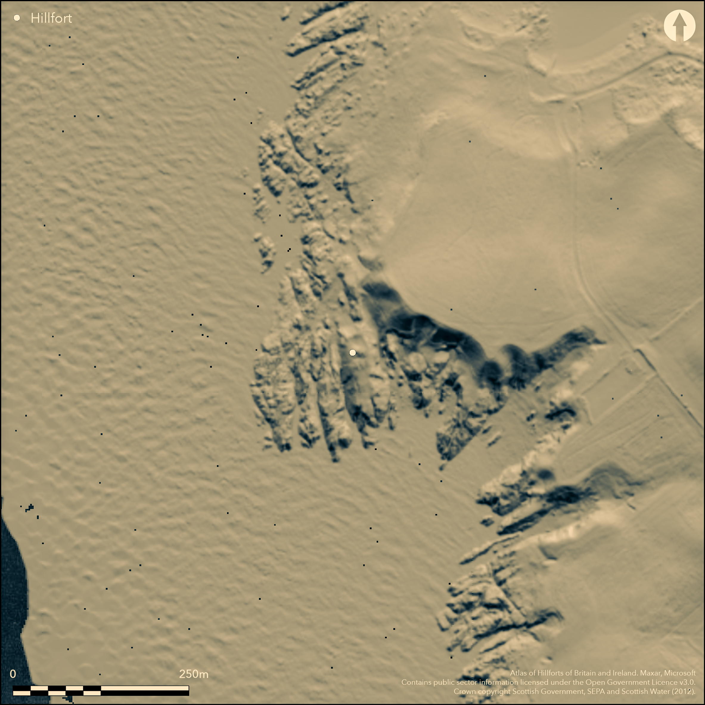
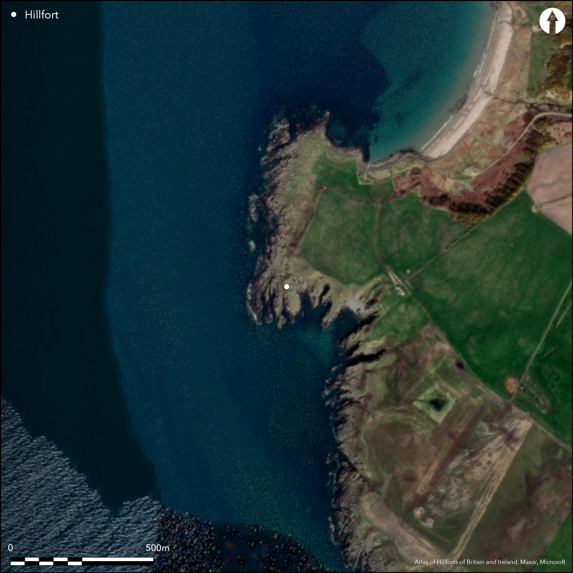
The broch on Ardwell Point stands on a promontory that is also protected by a wall drawn across the narrow neck on the N. While generally regarded as an outwork to the broch, there remains the possibility that this is also the remains of an earlier promontory enclosure, though it is by no means inaccessible from its flanks. The wall is at least 2.6m thick, forming a stony scarp on the N, where it faces into a natural gully some 6m broad and 2.3m deep. To either side it turns back southwards towards the broch and while no inner facing-stones are visible, the line of the outer face can be traced along both flanks, on the W standing 1.3m high in seven courses and probably once carried upwards by the outer face of the broch; it was thus possibly no more than a small defended annexe in front of the main entrance to the broch. Nevertheless, this wall also cuts off a much bigger area measuring about 65m from N to S by a maximum of 14m transversely (0.1ha). The presence of a second entrance in the broch giving access to the seaward end of the promontory certainly indicates that this area was also used in conjunction with the interior of the broch. The easiest line of approach to the promontory has always been from the N, and a causeway 1.9m wide and 0.9m high has been constructed across the gully at its neck. The broch itself measures 9m in diameter within a wall that varies between 3.75m and 4.6m in thickness, and is notable for having two opposed entrances.
Citizen Science: ✗
Reliability of Data: Confirmed
Reliability of Interpretation: Confirmed
X: -557243 Y: 7315387 (EPSG: 3857)
Longitude: -5.005802221417195 Latitude: 54.75980094118233 (EPSG:4326)
Country: Scotland
Current County or Unitary Authority: Dumfries & Galloway
Historic County: Wigtownshire
Current Parish/Community/Council/Townland: Stoneykirk
None
| Extant | ✓ |
| Cropmark | ✗ |
| Likely Destroyed | ✗ |
None
| Woodland | ✗ |
| Commercial Forestry Plantation | ✗ |
| Parkland | ✗ |
| Pasture (Grazing) | ✗ |
| Arable | ✗ |
| Scrub/Bracken | ✗ |
| Bare Outcrop | ✗ |
| Heather/Moorland | ✗ |
| Heath | ✗ |
| Built-up | ✗ |
| Coastal Grassland | ✓ |
| Other | ✗ |
None
| Contour Fort | ✗ |
| Partial Contour Fort | ✗ |
| Promontory Fort | ✓ |
| Hillslope Fort | ✗ |
| Level Terrain Fort | ✗ |
| Marsh Fort | ✗ |
| Multiple Enclosure Fort | ✗ |
| Hilltop | ✗ |
| Coastal Promontory | ✓ |
| Inland Promontory | ✗ |
| Valley Bottom | ✗ |
| Knoll/Hillock/Outcrop | ✗ |
| Ridge | ✗ |
| Cliff/Plateau-edge/Scarp | ✗ |
| Hillslope | ✗ |
| Lowland | ✗ |
| Spur | ✗ |
Dominant Topographic Feature: None
| North | ✗ |
| Northeast | ✗ |
| East | ✗ |
| Southeast | ✗ |
| South | ✗ |
| Southwest | ✗ |
| West | ✗ |
| Northwest | ✗ |
| Level | ✓ |
Altitude: 10.0m
N/A
In the absence of excavation, there are neither stratified artefacts nor radiocarbon dates to provide a chronology for the outer defences.
Reliability: D - None
| Pre 1200BC | ✗ |
| 1200BC - 800BC | ✗ |
| 800BC - 400BC | ✗ |
| 400BC - AD50 | ✗ |
| AD50 - AD400 | ✗ |
| AD400 - AD 800 | ✗ |
| Post AD800 | ✗ |
| Unknown | ✓ |
| Pre Hillfort: | None |
| Post Hillfort: | None |
| Morphology/Earthwork/Typology: | Broch |
While the headland is named ÇDune of Ardwell' on Roy's map (1747-55), and it is presumably one of the Pictish castles referred to in the New Statistical Account (iv, Wigtonshire, 164), the broch seems to have escaped depiction until the preparation 1847-8 of the 1st edition OS 6-inch map (Wigtownshire 1850, sheet 27). It subsequently appears on the OS 25-inch map (Wigtownshire 1894, sheet 28.12) as a mound hachured inside and out in two opposed crescents. Described in 1911 by Alexander Curle during the preparation of the County Inventory for Wigtownshire (RCAHMS 1912, 152, no.433), in 1955 plans were drawn up by RCAHMS as part of the Survey of Marginal Lands, at which time the outwork was first recognised. In 1972 it was resurveyed at 1:2500 by the OS, and in 1984 revisited again by RCAHMS as part of a wider survey of the Rhinns of Galloway. It was also visite by Euan MacKie in 1967 and 1989 (MacKie 2007, 1325-6)
| 1st Identified Map Depiction (1848): | Named in Gothic type on the1st edition OS 6-inch map (Wigtownshire 1850, sheet 27) |
| Other (1911): | Description (RCAHMS 1912, 152, no.433) |
| Earthwork Survey (1955): | 1:120 & 1:300 (RCAHMS WGD 1/1-6; DP 151571-5 & DP023786) |
| Other (1967): | Description by Euan MacKie (2007, 1325-6) |
| Other (1972): | Resurveyed at 1:2500 by the OS |
| Other (1980): | Description by Euan MacKie (2007, 1325-6) |
| Other (1984): | Description by RCAHMS |
| Other (1995): | Re-Scheduled (earlier scheduling?) |
| Other (2014): | Visit by the Hillfort Study Group |
Broch
None
| None | ✓ |
| Spring | ✗ |
| Stream | ✗ |
| Pool | ✗ |
| Flush | ✗ |
| Well | ✗ |
| Other | ✗ |
Broch
| No Known Features | ✗ |
| Round Stone Structures | ✗ |
| Rectangular Stone Structures | ✗ |
| Curvilinear Platforms | ✗ |
| Other Roundhouse Evidence | ✗ |
| Pits | ✗ |
| Quarry Hollows | ✗ |
| Other | ✓ |
None
| No Known Excavation | ✓ |
| Pits | ✗ |
| Postholes | ✗ |
| Roundhouses | ✗ |
| Rectangular Structures | ✗ |
| Roads/Tracks | ✗ |
| Quarry Hollows | ✗ |
| Other | ✗ |
| Nothing Found | ✗ |
None
| No Known Geophysics | ✓ |
| Pits | ✗ |
| Roundhouses | ✗ |
| Rectangular Structures | ✗ |
| Roads/Tracks | ✗ |
| Quarry Hollows | ✗ |
| Other | ✗ |
| Nothing Found | ✗ |
None
| No Known Finds | ✓ |
| Pottery | ✗ |
| Metal | ✗ |
| Metalworking | ✗ |
| Human Bones | ✗ |
| Animal Bones | ✗ |
| Lithics | ✗ |
| Environmental | ✗ |
| Other | ✗ |
NO APPARENT FEATURES
| APs Not Checked | ✗ |
| None | ✓ |
| Roundhouses | ✗ |
| Rectangular Structures | ✗ |
| Pits | ✗ |
| Postholes | ✗ |
| Roads/Tracks | ✗ |
| Other | ✗ |
See main summary
| 1: | None |
| 2: | None |
Guard Chambers: ✗
Chevaux de Frise: ✗
| 1. Simple Gap (North): | Approached by built causeway |
Single wall across the promontory
| Area 1: | 0.1ha. |
| Total: | 0.1ha. |
Total Footprint Area: Noneha.
None
| ✗ | None |
| ✗ | None |
| NE Quadrant: | 1 |
| SE Quadrant: | 0 |
| SW Quadrant: | 0 |
| NW Quadrant: | 1 |
| Total: | 1 |
| Partial Univallate | ✓ |
| Univallate | ✗ |
| Partial Bivallate | ✗ |
| Bivallate | ✗ |
| Partial Multivallate | ✗ |
| Multivallate | ✗ |
| Unknown | ✗ |
| Partial Univallate | ✗ |
| Univallate | ✗ |
| Partial Bivallate | ✗ |
| Bivallate | ✗ |
| Partial Multivallate | ✗ |
| Multivallate | ✗ |
None
| None | ✗ |
| Earthen Bank | ✗ |
| Stone Wall | ✓ |
| Rubble | ✗ |
| Wall-walk | ✗ |
| Evidence of Timber | ✗ |
| Vitrification | ✗ |
| Other Burning | ✗ |
| Palisade | ✗ |
| Counter Scarp Bank | ✗ |
| Berm | ✗ |
| Unfinished | ✗ |
| Other | ✗ |
None
| None | ✗ |
| Earthen Bank | ✗ |
| Stone Wall | ✗ |
| Murus Duplex | ✗ |
| Timber-framed | ✗ |
| Timber-laced | ✗ |
| Vitrification | ✗ |
| Other Burning | ✗ |
| Palisade | ✗ |
| Counter Scarp Bank | ✗ |
| Berm | ✗ |
| Unfinished | ✗ |
| No Known Excavation | ✓ |
| Other | ✗ |
| ✗ | None |
| ✗ | Natural gull serves as a ditch |
Number of Ditches: None
| ✗ | None |
Feachem, R (1963) A guide to prehistoric Scotland, London (p 174)
MacKie, E W (2007) The Roundhouses, Brochs and Wheelhouses of Atlantic Scotland c.700 BC-AD 500: architecture and material culture, the Northern and Southern Mainland and the Western Islands, BAR British Ser, Oxford
NSA (1834-1845) The new statistical account of Scotland by the ministers of the respective parishes under the superintendence of a committee of the society for the benefit of the sons and daughters of the clergy.
RCAHMS (1912) The Royal Commission on the Ancient and Historical Monuments and Constructions of Scotland. Fourth report and inventory of monuments and constructions in Galloway, 1, County of Wigtown, Edinburgh
Atlas of Hillforts:
Wikidata:
This work is licensed under CC BY-SA 4.0![]()
![]()
![]() and should be cited as:
and should be cited as:
Lock, Gary and Ralston, Ian. 2024. Atlas of Hillforts of Britain and Ireland. Available at: https://hillforts.arch.ox.ac.uk
Document Version 1.1