LiDAR 1m DTM Hillshade
Satellite Imagery
LiDAR 1m DTM Hillshade
Satellite Imagery
Scroll left/right to view further images.
HER: The West of Scotland Archaeology Service 11434 (None)
NMR: NX 19 NE 7 (62075)
SM: 2525
NGR: NX 1928 9608
X: 219280 Y: 596080 (OSGB36)
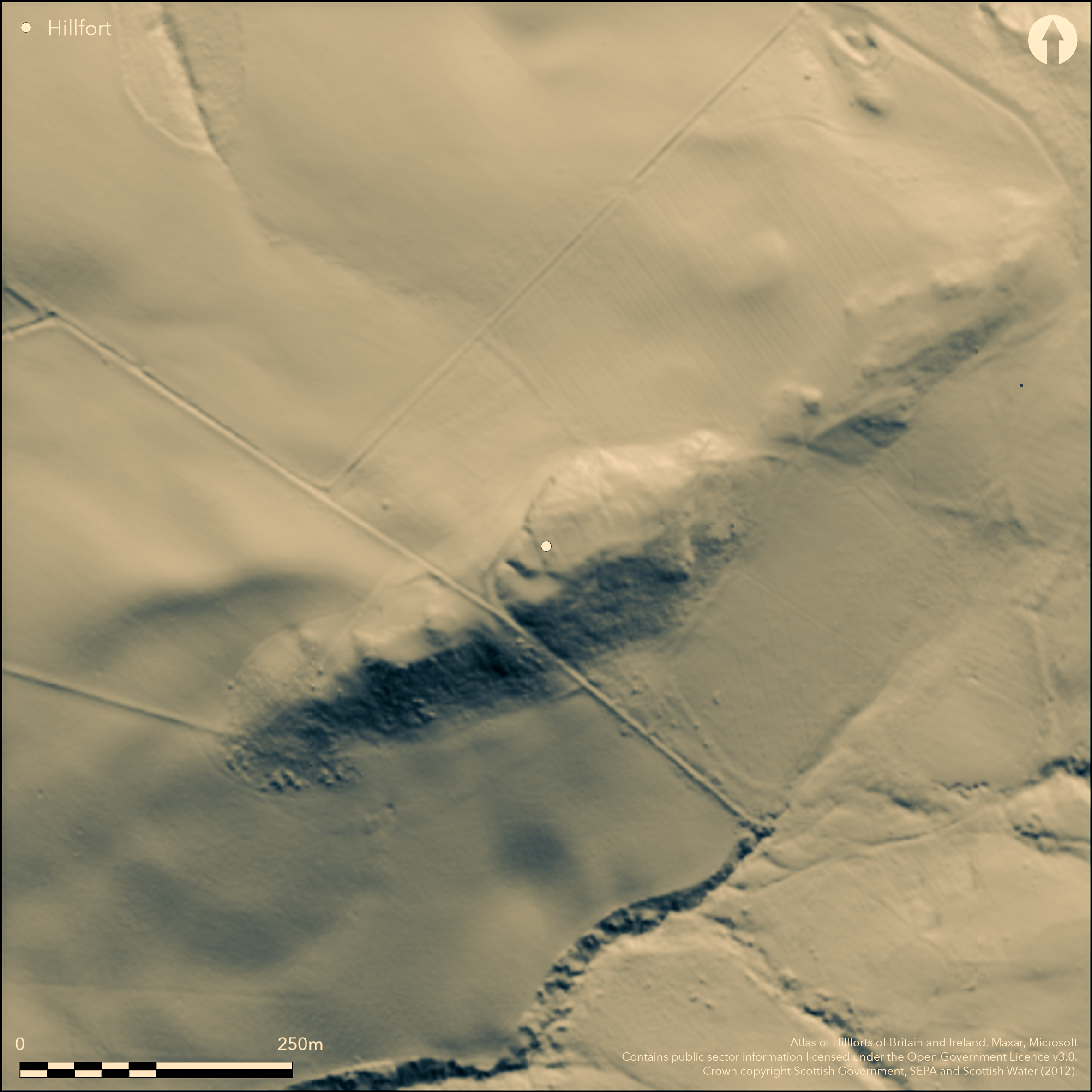
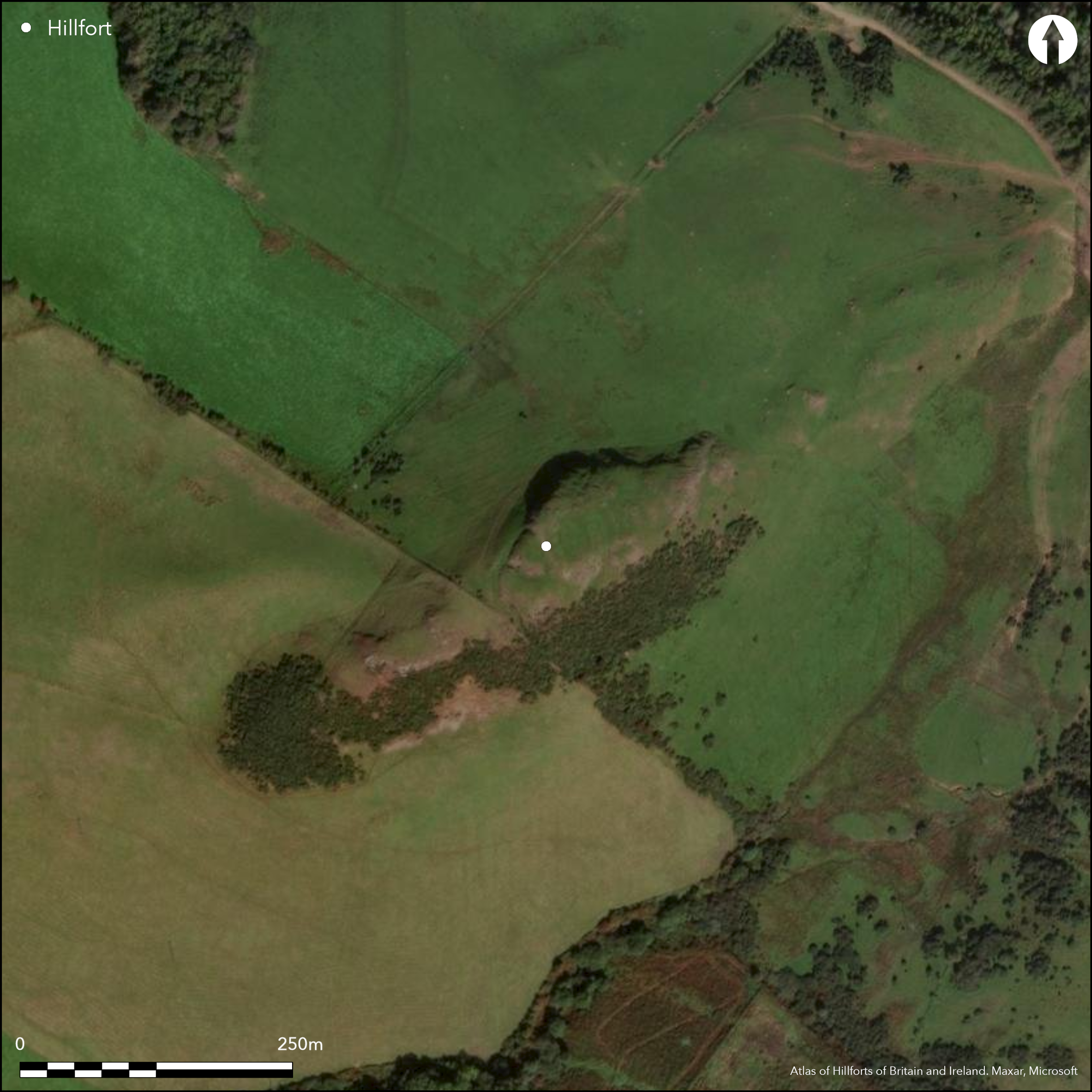
This fortification has been very heavily robbed, so much so that it is uncertain whether the remains here comprise a dun with its outworks, or a small fort overlain by a later dun. Indeed, the presence of the dun, which measures a maximum of 15m in diameter within a broad band of rubble, is the only feature about which all investigators are agreed. It is situated on the summit of this rocky ridge, which drops away precipitously along its northern flank. On the ENE, the outer defences comprise a single stony scarp about 0.6m high, which cuts across the spine of the ridge, but the four terraces that David Christison identified descending the slope below are probably natural (1893, 392-3, fig 8). On the opposite side of the dun, on the SW, stony debris can also be seen along the leading edges of two other terraces. Below these terraces on the W a rock-cut ditch about 3.2m in breadth extends round to the foot of the outcrops on the northern slopes, where there is also a terraced trackway climbing obliquely up the slope, though whether to provide access to the fortifications on the summit or heading for the braided trackways that can be seen climbing the hill about 300m to the E, is not clear. If there is an earlier fort here, its interior probably measures no more than 40m from NE to SW by 15m transversely (0.06ha).
Citizen Science: ✗
Reliability of Data: Confirmed
Reliability of Interpretation: Unconfirmed
X: -539124 Y: 7405812 (EPSG: 3857)
Longitude: -4.843035509398666 Latitude: 55.225793922850634 (EPSG:4326)
Country: Scotland
Current County or Unitary Authority: South Ayrshire
Historic County: Ayrshire
Current Parish/Community/Council/Townland: Girvan
None
| Extant | ✓ |
| Cropmark | ✗ |
| Likely Destroyed | ✗ |
None
| Woodland | ✗ |
| Commercial Forestry Plantation | ✗ |
| Parkland | ✗ |
| Pasture (Grazing) | ✓ |
| Arable | ✗ |
| Scrub/Bracken | ✗ |
| Bare Outcrop | ✗ |
| Heather/Moorland | ✗ |
| Heath | ✗ |
| Built-up | ✗ |
| Coastal Grassland | ✗ |
| Other | ✗ |
None
| Contour Fort | ✓ |
| Partial Contour Fort | ✗ |
| Promontory Fort | ✗ |
| Hillslope Fort | ✗ |
| Level Terrain Fort | ✗ |
| Marsh Fort | ✗ |
| Multiple Enclosure Fort | ✗ |
| Hilltop | ✓ |
| Coastal Promontory | ✗ |
| Inland Promontory | ✗ |
| Valley Bottom | ✗ |
| Knoll/Hillock/Outcrop | ✗ |
| Ridge | ✗ |
| Cliff/Plateau-edge/Scarp | ✗ |
| Hillslope | ✗ |
| Lowland | ✗ |
| Spur | ✗ |
Dominant Topographic Feature: None
| North | ✗ |
| Northeast | ✗ |
| East | ✗ |
| Southeast | ✗ |
| South | ✗ |
| Southwest | ✗ |
| West | ✗ |
| Northwest | ✗ |
| Level | ✓ |
Altitude: 150.0m
N/A
In the absence of excavation, there are neither stratified artefacts nor radiocarbon dates to provide a chronology for the defences.
Reliability: D - None
| Pre 1200BC | ✗ |
| 1200BC - 800BC | ✗ |
| 800BC - 400BC | ✗ |
| 400BC - AD50 | ✗ |
| AD50 - AD400 | ✗ |
| AD400 - AD 800 | ✗ |
| Post AD800 | ✗ |
| Unknown | ✓ |
| Pre Hillfort: | None |
| Post Hillfort: | Heavy stone-robbing |
First depicted in 1856 on the 1st edition of the OS 25-inch map (Ayrchire 1859, sheet 55.8), it was sketch-planned by David Christison about 1891 (1893, 392-3, fig 8), and probably revisited by John Smith shortly before 1895 (Smith 1895, 214). It was visited by RCAHMS in 1953, followed shortly after in 1955 by the OS. The OS returned to re-survey at 1:2500 in 1963 and revisited once more in 1977. RCAHMS revisited in 1982.
| 1st Identified Map Depiction (1856): | Named Camp on the 1st edition OS 25-inch map (Ayrchire 1859, sheet 55.8) |
| Earthwork Survey (1891): | Sketch-plan and description (Christison 1893, 392-3, fig 8) |
| Other (1895): | Description (Smith 1895, 214) |
| Other (1953): | Description during RCAHMS Survey of Marginal Lands |
| Other (1963): | Resurveyed at 1:2500 by the OS |
| Other (1965): | Scheduled |
| Other (1977): | Surveyed at 1:10.000 by the OS |
| Other (1982): | Description by RCAHMS |
| Other (1983): | Visited by the Hill-Fort Study Group |
Apart from the dun itself the interior is featureless
None
| None | ✓ |
| Spring | ✗ |
| Stream | ✗ |
| Pool | ✗ |
| Flush | ✗ |
| Well | ✗ |
| Other | ✗ |
None
| No Known Features | ✓ |
| Round Stone Structures | ✗ |
| Rectangular Stone Structures | ✗ |
| Curvilinear Platforms | ✗ |
| Other Roundhouse Evidence | ✗ |
| Pits | ✗ |
| Quarry Hollows | ✗ |
| Other | ✗ |
None
| No Known Excavation | ✓ |
| Pits | ✗ |
| Postholes | ✗ |
| Roundhouses | ✗ |
| Rectangular Structures | ✗ |
| Roads/Tracks | ✗ |
| Quarry Hollows | ✗ |
| Other | ✗ |
| Nothing Found | ✗ |
None
| No Known Geophysics | ✓ |
| Pits | ✗ |
| Roundhouses | ✗ |
| Rectangular Structures | ✗ |
| Roads/Tracks | ✗ |
| Quarry Hollows | ✗ |
| Other | ✗ |
| Nothing Found | ✗ |
None
| No Known Finds | ✓ |
| Pottery | ✗ |
| Metal | ✗ |
| Metalworking | ✗ |
| Human Bones | ✗ |
| Animal Bones | ✗ |
| Lithics | ✗ |
| Environmental | ✗ |
| Other | ✗ |
NO APPARENT FEATURES
| APs Not Checked | ✗ |
| None | ✓ |
| Roundhouses | ✗ |
| Rectangular Structures | ✗ |
| Pits | ✗ |
| Postholes | ✗ |
| Roads/Tracks | ✗ |
| Other | ✗ |
See main summary
| 0: | None |
| 2: | Unknown |
Guard Chambers: ✗
Chevaux de Frise: ✗
While Richard Feachem believed there were traces of up to five ramparts on the E (1963, 109), the supposed defences, which are of fairly disparate character on different flanks, are too heavily robbed to be certain.
| Area 1: | 0.06ha. |
| Total: | 0.06ha. |
Total Footprint Area: Noneha.
None
| ✗ | None |
| ✗ | None |
| NE Quadrant: | 1 |
| SE Quadrant: | 1 |
| SW Quadrant: | 2 |
| NW Quadrant: | 0 |
| Total: | 2 |
| Partial Univallate | ✓ |
| Univallate | ✗ |
| Partial Bivallate | ✓ |
| Bivallate | ✗ |
| Partial Multivallate | ✗ |
| Multivallate | ✗ |
| Unknown | ✗ |
| Partial Univallate | ✗ |
| Univallate | ✗ |
| Partial Bivallate | ✗ |
| Bivallate | ✗ |
| Partial Multivallate | ✗ |
| Multivallate | ✗ |
None
| None | ✓ |
| Earthen Bank | ✗ |
| Stone Wall | ✗ |
| Rubble | ✗ |
| Wall-walk | ✗ |
| Evidence of Timber | ✗ |
| Vitrification | ✗ |
| Other Burning | ✗ |
| Palisade | ✗ |
| Counter Scarp Bank | ✗ |
| Berm | ✗ |
| Unfinished | ✗ |
| Other | ✗ |
None
| None | ✗ |
| Earthen Bank | ✗ |
| Stone Wall | ✗ |
| Murus Duplex | ✗ |
| Timber-framed | ✗ |
| Timber-laced | ✗ |
| Vitrification | ✗ |
| Other Burning | ✗ |
| Palisade | ✗ |
| Counter Scarp Bank | ✗ |
| Berm | ✗ |
| Unfinished | ✗ |
| No Known Excavation | ✓ |
| Other | ✗ |
| ✗ | None |
| ✓ | Short sector on the W |
Number of Ditches: 1
| ✗ | None |
Christison, D (1893) 'The prehistoric forts of Ayrshire', Proc Soc Antiq Scot 27, 381-405
Feachem, R (196b) A guide to prehistoric Scotland, London
Smith, J (1895) Prehistoric man in Ayrshire, London
Atlas of Hillforts:
Wikidata:
This work is licensed under CC BY-SA 4.0![]()
![]()
![]() and should be cited as:
and should be cited as:
Lock, Gary and Ralston, Ian. 2024. Atlas of Hillforts of Britain and Ireland. Available at: https://hillforts.arch.ox.ac.uk
Document Version 1.1