LiDAR 1m DTM Hillshade
Satellite Imagery
LiDAR 1m DTM Hillshade
Satellite Imagery
Scroll left/right to view further images.
HER: Dumfries & Galloway MDG12130 (None)
NMR: NY 07 NE 8 (66132)
SM: 658
NGR: NY 0864 7639
X: 308640 Y: 576390 (OSGB36)
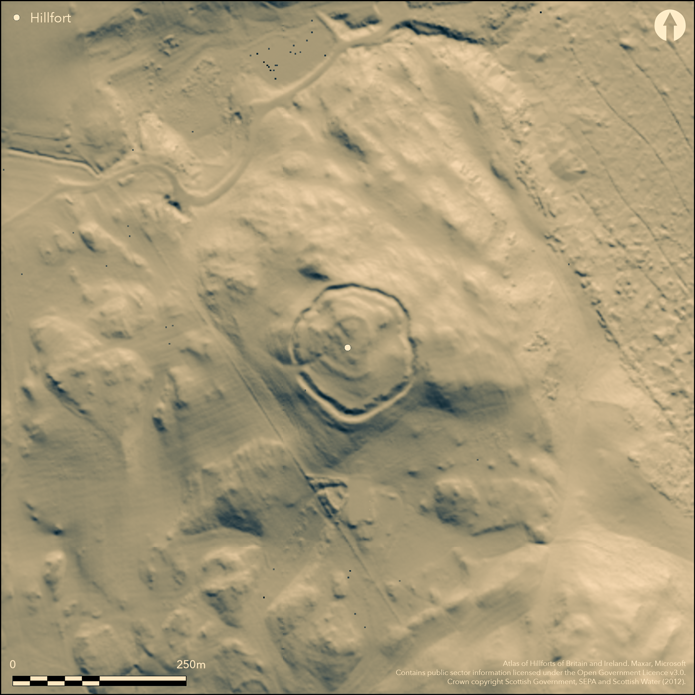
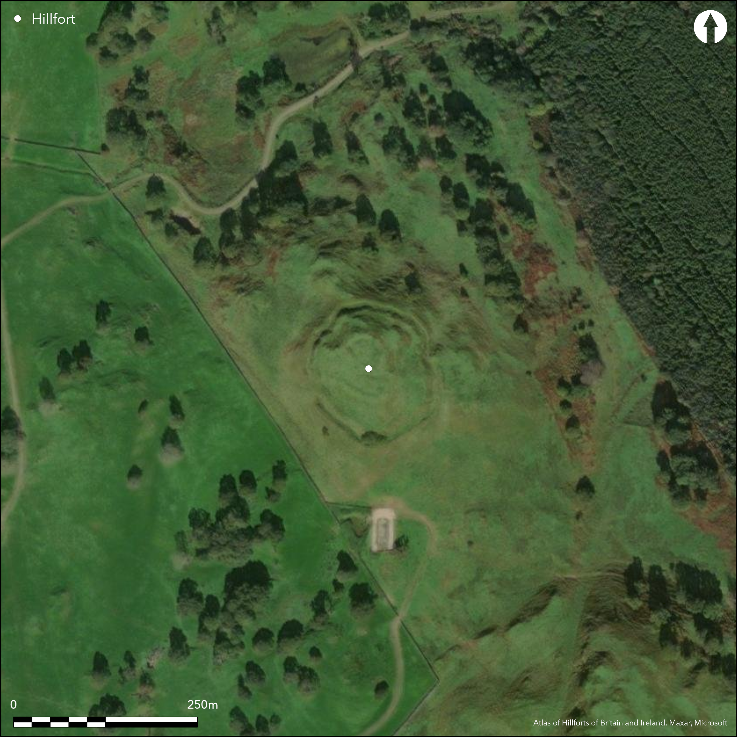
This fort occupies a hillock on the escarpment forming the W flank of Annandale and displays at least three separate lines of enclosure. The principal line of defence, and for the purposes of the Atlas, that of the fort, is the outermost, comprising twin ramparts, the inner of which still stands up to 2.5m above the bottom of a medial rock-cut ditch at least 5m in breadth; there is another short length of ditch lying outside this line on the SE. These defences enclose an area of 0.6ha, but within the interior, which rises towards the summit, there is not only a stony scarp up to 1.1m high enclosing an area measuring 52m from N to S by 40m transversely (0.16ha), but on the summit itself an enclosure measuring 37m from N to S by 25m transversely (0.06ha) within a band of rubble 3m in thickness by 0.4m in height. The main entrance to the fort is on the W, where there is a causeway across the ditch and a trackway leads up to a gap in the scarp forming the middle line of enclosure within interior, but there is also another causeway across the ditch on the SE.
Citizen Science: ✗
Reliability of Data: Confirmed
Reliability of Interpretation: Confirmed
X: -382092 Y: 7376155 (EPSG: 3857)
Longitude: -3.4323912899454934 Latitude: 55.073558134093666 (EPSG:4326)
Country: Scotland
Current County or Unitary Authority: Dumfries & Galloway
Historic County: Dumfriesshire
Current Parish/Community/Council/Townland: Dalton
None
| Extant | ✓ |
| Cropmark | ✗ |
| Likely Destroyed | ✗ |
None
| Woodland | ✗ |
| Commercial Forestry Plantation | ✗ |
| Parkland | ✗ |
| Pasture (Grazing) | ✓ |
| Arable | ✗ |
| Scrub/Bracken | ✗ |
| Bare Outcrop | ✗ |
| Heather/Moorland | ✓ |
| Heath | ✗ |
| Built-up | ✗ |
| Coastal Grassland | ✗ |
| Other | ✗ |
None
| Contour Fort | ✓ |
| Partial Contour Fort | ✗ |
| Promontory Fort | ✗ |
| Hillslope Fort | ✗ |
| Level Terrain Fort | ✗ |
| Marsh Fort | ✗ |
| Multiple Enclosure Fort | ✓ |
| Hilltop | ✓ |
| Coastal Promontory | ✗ |
| Inland Promontory | ✗ |
| Valley Bottom | ✗ |
| Knoll/Hillock/Outcrop | ✗ |
| Ridge | ✗ |
| Cliff/Plateau-edge/Scarp | ✗ |
| Hillslope | ✗ |
| Lowland | ✗ |
| Spur | ✗ |
Dominant Topographic Feature: None
| North | ✗ |
| Northeast | ✗ |
| East | ✗ |
| Southeast | ✗ |
| South | ✗ |
| Southwest | ✗ |
| West | ✗ |
| Northwest | ✗ |
| Level | ✓ |
Altitude: 180.0m
N/A
In the absence of excavation, there are neither stratified artefacts nor radiocarbon dates to provide a chronology for the defences.
Reliability: D - None
| Pre 1200BC | ✗ |
| 1200BC - 800BC | ✗ |
| 800BC - 400BC | ✗ |
| 400BC - AD50 | ✗ |
| AD50 - AD400 | ✗ |
| AD400 - AD 800 | ✗ |
| Post AD800 | ✗ |
| Unknown | ✓ |
| Pre Hillfort: | None |
| Post Hillfort: | The innermost enclosure may belong to a small late Iron Age settlement rather than a phase of fortification |
First depicted in 1856 on the 1st edition OS 25-inch map (Dumfriesshire 1861, sheet 50.15), where it was annotated 'Camp (Supposed British)', it was subsequently visited in 1912 by Alexander Curle during the preparation of the County Inventory for Dumfriesshire (RCAHMS 1920, 42-3, no.98, fig. 38) and a plan drawn up. It was Scheduled in 1937 and the OS re-surveyed at 1:2500 in 1966 and re-visited in 1973.
| 1st Identified Map Depiction (1856): | Annotated Camp on the 1st edition OS 25-inch map (Dumfriesshire 1861, sheet 50.15) |
| Earthwork Survey (1912): | and description (RCAHMS 1920, 42-3, no.98, fig. 38) |
| Other (1937): | Scheduled |
| Other (1966): | Resurveyed at 1:2500 by the OS |
| Other (1973): | Resurveyed at 1:2500 by the OS |
Featureless, apart from the inner lines of enclosure
None
| None | ✓ |
| Spring | ✗ |
| Stream | ✗ |
| Pool | ✗ |
| Flush | ✗ |
| Well | ✗ |
| Other | ✗ |
None
| No Known Features | ✓ |
| Round Stone Structures | ✗ |
| Rectangular Stone Structures | ✗ |
| Curvilinear Platforms | ✗ |
| Other Roundhouse Evidence | ✗ |
| Pits | ✗ |
| Quarry Hollows | ✗ |
| Other | ✗ |
None
| No Known Excavation | ✓ |
| Pits | ✗ |
| Postholes | ✗ |
| Roundhouses | ✗ |
| Rectangular Structures | ✗ |
| Roads/Tracks | ✗ |
| Quarry Hollows | ✗ |
| Other | ✗ |
| Nothing Found | ✗ |
None
| No Known Geophysics | ✓ |
| Pits | ✗ |
| Roundhouses | ✗ |
| Rectangular Structures | ✗ |
| Roads/Tracks | ✗ |
| Quarry Hollows | ✗ |
| Other | ✗ |
| Nothing Found | ✗ |
None
| No Known Finds | ✓ |
| Pottery | ✗ |
| Metal | ✗ |
| Metalworking | ✗ |
| Human Bones | ✗ |
| Animal Bones | ✗ |
| Lithics | ✗ |
| Environmental | ✗ |
| Other | ✗ |
NO APPARENT FEATURES
| APs Not Checked | ✗ |
| None | ✓ |
| Roundhouses | ✗ |
| Rectangular Structures | ✗ |
| Pits | ✗ |
| Postholes | ✗ |
| Roads/Tracks | ✗ |
| Other | ✗ |
See main summary
| 2: | None |
| 2: | None |
Guard Chambers: ✗
Chevaux de Frise: ✗
| 1. Simple Gap (South east): | None |
| 2. Hollow Way (West): | None |
| 2. Simple Gap (West): | None |
There are three lines of enclosure here, the main being the outer at 0.6ha; the middle line encloses 0.16ha, and the innermost on the summit 0.07ha, but probably representing separate phases.
| Area 1: | 0.07ha. |
| Area 2: | 0.16ha. |
| Area 3: | 0.6ha. |
| Total: | 0.6ha. |
Total Footprint Area: 0.95ha.
None
| ✗ | While no stratigraphic sequence can be demonstrated, it is likely that the three lines represent separate periods of construction |
| ✓ | None |
| NE Quadrant: | 3 |
| SE Quadrant: | 3 |
| SW Quadrant: | 3 |
| NW Quadrant: | 3 |
| Total: | 3 |
| Partial Univallate | ✗ |
| Univallate | ✗ |
| Partial Bivallate | ✗ |
| Bivallate | ✗ |
| Partial Multivallate | ✗ |
| Multivallate | ✓ |
| Unknown | ✗ |
| Partial Univallate | ✗ |
| Univallate | ✓ |
| Partial Bivallate | ✗ |
| Bivallate | ✗ |
| Partial Multivallate | ✗ |
| Multivallate | ✗ |
None
| None | ✗ |
| Earthen Bank | ✓ |
| Stone Wall | ✗ |
| Rubble | ✓ |
| Wall-walk | ✗ |
| Evidence of Timber | ✗ |
| Vitrification | ✗ |
| Other Burning | ✗ |
| Palisade | ✗ |
| Counter Scarp Bank | ✗ |
| Berm | ✗ |
| Unfinished | ✗ |
| Other | ✗ |
None
| None | ✗ |
| Earthen Bank | ✗ |
| Stone Wall | ✗ |
| Murus Duplex | ✗ |
| Timber-framed | ✗ |
| Timber-laced | ✗ |
| Vitrification | ✗ |
| Other Burning | ✗ |
| Palisade | ✗ |
| Counter Scarp Bank | ✗ |
| Berm | ✗ |
| Unfinished | ✗ |
| No Known Excavation | ✓ |
| Other | ✗ |
| ✗ | None |
| ✓ | None |
Number of Ditches: 1
| ✗ | None |
Feachem, R (1963) A guide to prehistoric Scotland, London (p 117)
RCAHMS (1920) The Royal Commission on the Ancient and Historical Monuments of Scotland. Seventh report with Inventory of Monuments and Constructions in the County of Dumfries. HMSO: Edinburgh
Atlas of Hillforts:
Wikidata:
This work is licensed under CC BY-SA 4.0![]()
![]()
![]() and should be cited as:
and should be cited as:
Lock, Gary and Ralston, Ian. 2024. Atlas of Hillforts of Britain and Ireland. Available at: https://hillforts.arch.ox.ac.uk
Document Version 1.1