LiDAR 1m DTM Hillshade
Satellite Imagery
LiDAR 1m DTM Hillshade
Satellite Imagery
Scroll left/right to view further images.
HER: Dumfries & Galloway MDG12178 (None)
NMR: NY 08 SW 2 (66328)
SM: 643
NGR: NY 0152 8344
X: 301520 Y: 583440 (OSGB36)
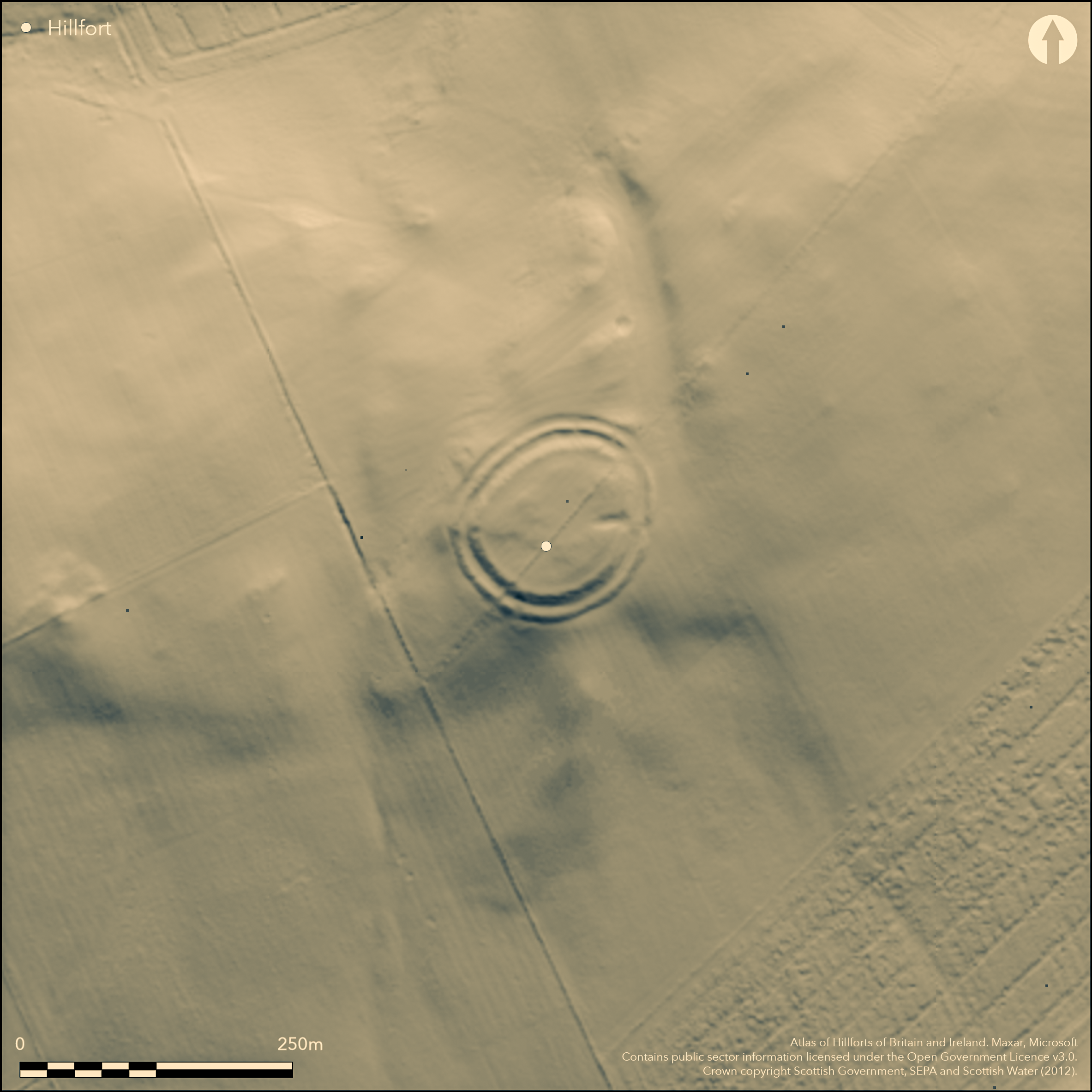
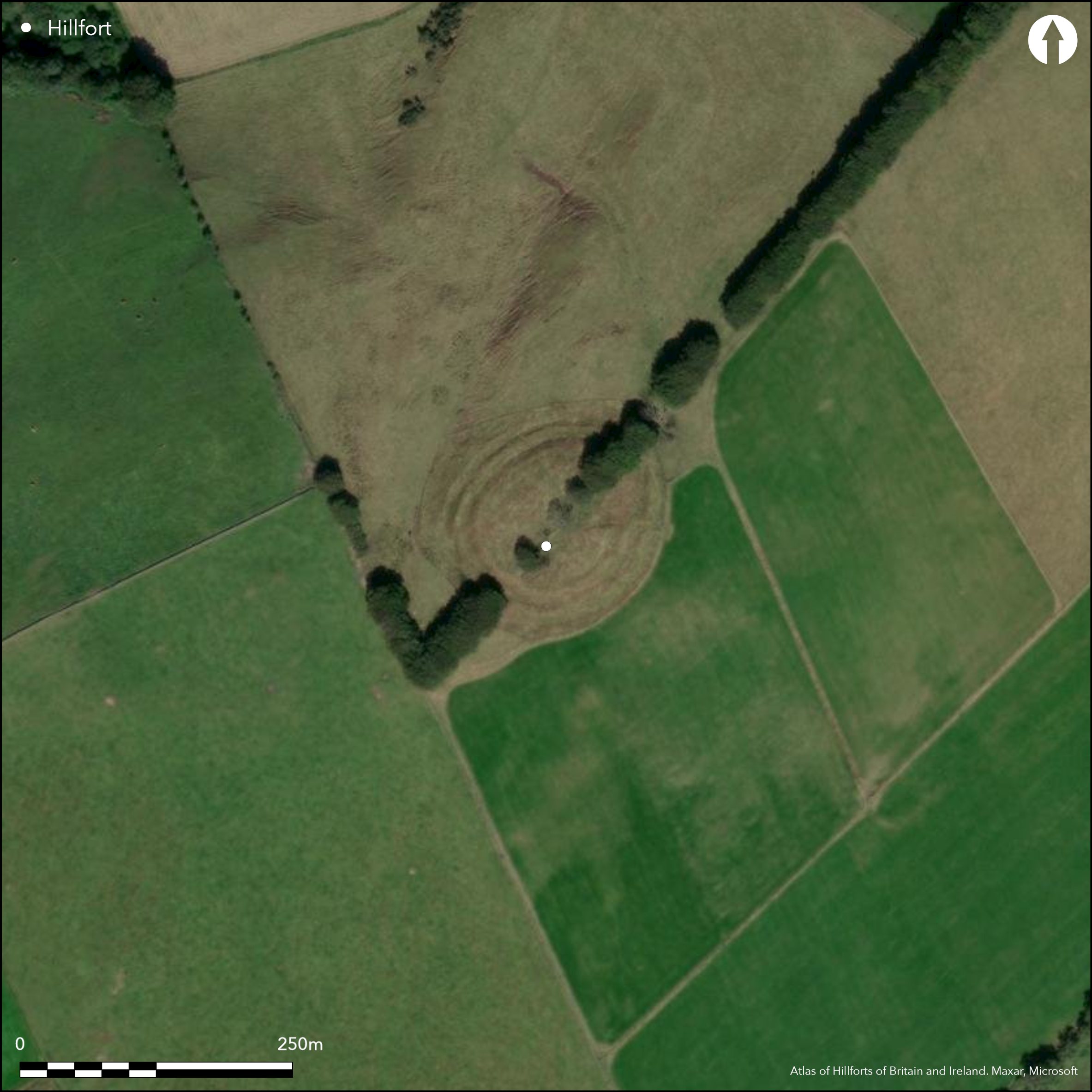
This fort is situated on the summit of Barr's Hill, a ridge aligned E and W and forming the northern terminal of the high ground to the E of Amisfield. Oval on plan, the fort measures 82m from NE to SW by 65m transversely within a band of defences 20m deep, where they are best preserved on the NW comprising twin ramparts and intermediate ditches, the outer accompanied by a counterscarp bank. Cultivation has taken its toll on the defences and while the innermost rampart forms a scarp standing 2.5m above the bottom of the inner ditch, around the SE half the outer ditch and its counterscarp bank are largely ploughed out. The entrance is on the E, where the entrance-way forms a deep hollow cutting through the innermost rampart as it rises into the interior. The Interior is featureless.
Citizen Science: ✓
Reliability of Data: Confirmed
Reliability of Interpretation: Confirmed
X: -394773 Y: 7388213 (EPSG: 3857)
Longitude: -3.5463032060855877 Latitude: 55.135525386762914 (EPSG:4326)
Country: Scotland
Current County or Unitary Authority: Dumfries & Galloway
Historic County: Dumfriesshire
Current Parish/Community/Council/Townland: Tinwald
None
| Extant | ✓ |
| Cropmark | ✗ |
| Likely Destroyed | ✗ |
None
| Woodland | ✗ |
| Commercial Forestry Plantation | ✗ |
| Parkland | ✗ |
| Pasture (Grazing) | ✓ |
| Arable | ✗ |
| Scrub/Bracken | ✗ |
| Bare Outcrop | ✗ |
| Heather/Moorland | ✗ |
| Heath | ✗ |
| Built-up | ✗ |
| Coastal Grassland | ✗ |
| Other | ✗ |
None
| Contour Fort | ✓ |
| Partial Contour Fort | ✗ |
| Promontory Fort | ✗ |
| Hillslope Fort | ✗ |
| Level Terrain Fort | ✗ |
| Marsh Fort | ✗ |
| Multiple Enclosure Fort | ✗ |
| Hilltop | ✓ |
| Coastal Promontory | ✗ |
| Inland Promontory | ✗ |
| Valley Bottom | ✗ |
| Knoll/Hillock/Outcrop | ✗ |
| Ridge | ✗ |
| Cliff/Plateau-edge/Scarp | ✗ |
| Hillslope | ✗ |
| Lowland | ✗ |
| Spur | ✗ |
Dominant Topographic Feature: None
| North | ✗ |
| Northeast | ✗ |
| East | ✗ |
| Southeast | ✗ |
| South | ✗ |
| Southwest | ✗ |
| West | ✗ |
| Northwest | ✗ |
| Level | ✓ |
Altitude: 210.0m
N/A
In the absence of excavation, there are neither stratified artefacts nor radiocarbon dates to provide a chronology for the defences.
Reliability: D - None
| Pre 1200BC | ✗ |
| 1200BC - 800BC | ✗ |
| 800BC - 400BC | ✗ |
| 400BC - AD50 | ✗ |
| AD50 - AD400 | ✗ |
| AD400 - AD 800 | ✗ |
| Post AD800 | ✗ |
| Unknown | ✓ |
| Pre Hillfort: | None |
| Post Hillfort: | Bisected by shelter belt and partly cultivated |
First depicted by William Crawford on his Map of Dumfries-shire (1804), it was surveyed in more detail in 1855 for the 1st edition OS 25-inch map (Dumfriesshire 1861, sheet 41.16). It was subsequently planned in 1912 during the preparation of the County Inventory for Dumfriesshire (RCAHMS 1920, 198-9, no.581, fig 144). This plan shows lengths of an additional outer ditch and counterscarp bank on the NW and NE, though these are not visible on either satellite imagery or RCAHMS oblique aerial photographs, which accounts for Richard Feachem's assertion of a fourth rampart (1963, 117). The fort was Scheduled in 1937 and re-surveyed by the OS at 1:2500 in 1963. It was photographed under light snow in 2001 by RCAHMS Aerial Survey Programme.
| 1st Identified Map Depiction (1804): | William Crawford's Map of Dumfries-shire (1804) |
| Other (1855): | Annotated Camp on the 1st edition OS 25-inch map (Dumfriesshire 1861, sheet 41.16) |
| Earthwork Survey (1912): | Plan and description (RCAHMS 1920, 198-9, no.581, fig 144; RCAHMS DFD 11/1) |
| Other (1937): | Scheduled |
| Other (1963): | Resurveyed at 1:2500 by the OS |
Partly cultivated and apparently featureless
None
| None | ✓ |
| Spring | ✗ |
| Stream | ✗ |
| Pool | ✗ |
| Flush | ✗ |
| Well | ✗ |
| Other | ✗ |
None
| No Known Features | ✓ |
| Round Stone Structures | ✗ |
| Rectangular Stone Structures | ✗ |
| Curvilinear Platforms | ✗ |
| Other Roundhouse Evidence | ✗ |
| Pits | ✗ |
| Quarry Hollows | ✗ |
| Other | ✗ |
None
| No Known Excavation | ✓ |
| Pits | ✗ |
| Postholes | ✗ |
| Roundhouses | ✗ |
| Rectangular Structures | ✗ |
| Roads/Tracks | ✗ |
| Quarry Hollows | ✗ |
| Other | ✗ |
| Nothing Found | ✗ |
None
| No Known Geophysics | ✓ |
| Pits | ✗ |
| Roundhouses | ✗ |
| Rectangular Structures | ✗ |
| Roads/Tracks | ✗ |
| Quarry Hollows | ✗ |
| Other | ✗ |
| Nothing Found | ✗ |
None
| No Known Finds | ✓ |
| Pottery | ✗ |
| Metal | ✗ |
| Metalworking | ✗ |
| Human Bones | ✗ |
| Animal Bones | ✗ |
| Lithics | ✗ |
| Environmental | ✗ |
| Other | ✗ |
NO APPARENT FEATURES
| APs Not Checked | ✗ |
| None | ✓ |
| Roundhouses | ✗ |
| Rectangular Structures | ✗ |
| Pits | ✗ |
| Postholes | ✗ |
| Roads/Tracks | ✗ |
| Other | ✗ |
See main summary
| 1: | None |
| 2: | None |
Guard Chambers: ✗
Chevaux de Frise: ✗
| 1. Simple Gap (East): | With entrance way formong a deep hollow where it penetrates the innermost rampart. |
Twin ramparts with external ditches
| Area 1: | 0.43ha. |
| Total: | 0.43ha. |
Total Footprint Area: 0.99ha.
None
| ✗ | None |
| ✓ | None |
| NE Quadrant: | 2 |
| SE Quadrant: | 2 |
| SW Quadrant: | 2 |
| NW Quadrant: | 2 |
| Total: | 2 |
| Partial Univallate | ✗ |
| Univallate | ✗ |
| Partial Bivallate | ✗ |
| Bivallate | ✓ |
| Partial Multivallate | ✗ |
| Multivallate | ✗ |
| Unknown | ✗ |
| Partial Univallate | ✗ |
| Univallate | ✗ |
| Partial Bivallate | ✗ |
| Bivallate | ✗ |
| Partial Multivallate | ✗ |
| Multivallate | ✗ |
None
| None | ✗ |
| Earthen Bank | ✓ |
| Stone Wall | ✗ |
| Rubble | ✗ |
| Wall-walk | ✗ |
| Evidence of Timber | ✗ |
| Vitrification | ✗ |
| Other Burning | ✗ |
| Palisade | ✗ |
| Counter Scarp Bank | ✓ |
| Berm | ✗ |
| Unfinished | ✗ |
| Other | ✗ |
None
| None | ✗ |
| Earthen Bank | ✗ |
| Stone Wall | ✗ |
| Murus Duplex | ✗ |
| Timber-framed | ✗ |
| Timber-laced | ✗ |
| Vitrification | ✗ |
| Other Burning | ✗ |
| Palisade | ✗ |
| Counter Scarp Bank | ✗ |
| Berm | ✗ |
| Unfinished | ✗ |
| No Known Excavation | ✓ |
| Other | ✗ |
| ✗ | None |
| ✓ | None |
Number of Ditches: 2
| ✗ | None |
Feachem, R (1963) A guide to prehistoric Scotland, London
RCAHMS (1920) The Royal Commission on the Ancient and Historical Monuments of Scotland. Seventh Report with Inventory of Monuments and Constructions in the County of Dumfries. HMSO; Edinburgh
Atlas of Hillforts:
Wikidata:
This work is licensed under CC BY-SA 4.0![]()
![]()
![]() and should be cited as:
and should be cited as:
Lock, Gary and Ralston, Ian. 2024. Atlas of Hillforts of Britain and Ireland. Available at: https://hillforts.arch.ox.ac.uk
Document Version 1.1