Satellite Imagery
Satellite Imagery
HER: Dumfries & Galloway MDG7323 (None)
NMR: NY 19 SW 12 (66953)
SM: 12708
NGR: NY 1426 9355
X: 314260 Y: 593550 (OSGB36)
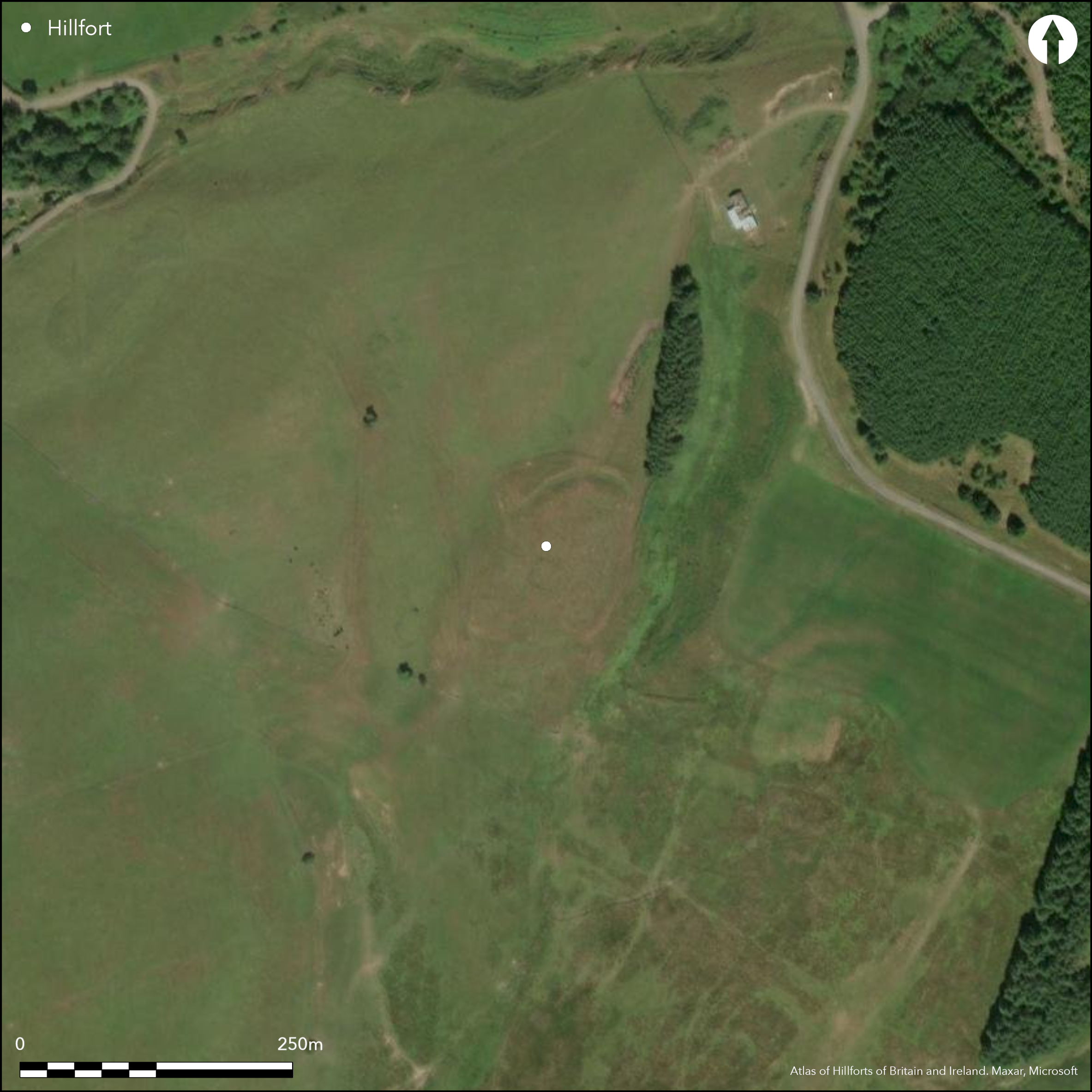
This fort, which is situated on a hillock at the foot of a spur of higher ground to the ENE, is overlain by a post-medieval farmstead. This occupies the whole of the interior and has obscured the character of the defences in the southern half of the fort and along its E side. Nevertheless, the outline of the defences can be broadly traced, enclosing a roughly oval area measuring about 82m from NNE to SSW by 70m transversely (0.42ha). Where best preserved, on the NW, they comprise an inner rampart some 6m thick by 1.2m high, with an external ditch 6m broad and a low counterscarp bank. The ditch has been largely ploughed out to the S of a field bank that crosses the defences on the W, while northwards it extends round to NE, where it disappears at the edge of a natural escarpment. At the S end the line of the rampart seems to turn inwards on both sides to form a deep re-entrant, but while this probably marks the position of the entrance, this part of the circuit has been heavily reduced and the rampart simply peters out to either side of a broad gap.
Citizen Science: ✗
Reliability of Data: Confirmed
Reliability of Interpretation: Confirmed
X: -372875 Y: 7406383 (EPSG: 3857)
Longitude: -3.349594743407973 Latitude: 55.22872050812946 (EPSG:4326)
Country: Scotland
Current County or Unitary Authority: Dumfries & Galloway
Historic County: Dumfriesshire
Current Parish/Community/Council/Townland: Wamphray
None
| Extant | ✓ |
| Cropmark | ✗ |
| Likely Destroyed | ✓ |
None
| Woodland | ✗ |
| Commercial Forestry Plantation | ✗ |
| Parkland | ✗ |
| Pasture (Grazing) | ✓ |
| Arable | ✗ |
| Scrub/Bracken | ✗ |
| Bare Outcrop | ✗ |
| Heather/Moorland | ✓ |
| Heath | ✗ |
| Built-up | ✗ |
| Coastal Grassland | ✗ |
| Other | ✗ |
None
| Contour Fort | ✓ |
| Partial Contour Fort | ✗ |
| Promontory Fort | ✗ |
| Hillslope Fort | ✗ |
| Level Terrain Fort | ✗ |
| Marsh Fort | ✗ |
| Multiple Enclosure Fort | ✗ |
| Hilltop | ✗ |
| Coastal Promontory | ✗ |
| Inland Promontory | ✗ |
| Valley Bottom | ✗ |
| Knoll/Hillock/Outcrop | ✓ |
| Ridge | ✗ |
| Cliff/Plateau-edge/Scarp | ✗ |
| Hillslope | ✗ |
| Lowland | ✗ |
| Spur | ✗ |
Dominant Topographic Feature: None
| North | ✗ |
| Northeast | ✗ |
| East | ✗ |
| Southeast | ✗ |
| South | ✗ |
| Southwest | ✗ |
| West | ✗ |
| Northwest | ✗ |
| Level | ✓ |
Altitude: 240.0m
N/A
In the absence of excavation, there are neither stratified artefacts nor radiocarbon dates to provide a chronology for the defences.
Reliability: D - None
| Pre 1200BC | ✗ |
| 1200BC - 800BC | ✗ |
| 800BC - 400BC | ✗ |
| 400BC - AD50 | ✗ |
| AD50 - AD400 | ✗ |
| AD400 - AD 800 | ✗ |
| Post AD800 | ✗ |
| Unknown | ✓ |
| Pre Hillfort: | None |
| Post Hillfort: | Overlain by post-medieval farmstead and field-banks |
First depicted in 1857 on the 1st edition OS 25-inch map (Dumfriesshire 1861, sheets 34.2 &34.6), it was visited in 1912 by Alexander Curle during the preparation of the County inventory for Dumfriesshire (RCAHMS 1920, 211, no.623). It was surveyed by George Jobey in 1968 during his fieldwork in eastern Dumfriesshire (Jobey 1971), and re-surveyed by the OS in 1972 at 1:2500 and revisited by them in 1978. A more detailed plan was drawn up by RCAHMS in 1990 (RCAHMS 1997, 232, fig 248). it was Scheduled in 2010
| 1st Identified Map Depiction (1857): | Annotated Fort on the 1st edition OS 25-inch map (Dumfriesshire 1861, sheets 34.2 &34.6) |
| Other (1912): | Description (RCAHMS 1920, 211, no.623) |
| Earthwork Survey (1968): | George Jobey (Copy in RCAHMS DFD 335/1 P/CO) |
| Other (1972): | Resurveyed at 1:2500 by the OS |
| Other (1978): | Surveyed at 1:10.000 by the OS |
| Earthwork Survey (1990): | Plan and description (RCAHMS 1997, 232, fig 248; RCAHMS DC32272 and SC382768) |
| Other (2010): | Scheduled |
Overlain by a postmedieval farmstead
None
| None | ✓ |
| Spring | ✗ |
| Stream | ✗ |
| Pool | ✗ |
| Flush | ✗ |
| Well | ✗ |
| Other | ✗ |
Buildings and enclosures of a post-medieval farmstead
| No Known Features | ✗ |
| Round Stone Structures | ✗ |
| Rectangular Stone Structures | ✓ |
| Curvilinear Platforms | ✗ |
| Other Roundhouse Evidence | ✗ |
| Pits | ✗ |
| Quarry Hollows | ✗ |
| Other | ✗ |
None
| No Known Excavation | ✓ |
| Pits | ✗ |
| Postholes | ✗ |
| Roundhouses | ✗ |
| Rectangular Structures | ✗ |
| Roads/Tracks | ✗ |
| Quarry Hollows | ✗ |
| Other | ✗ |
| Nothing Found | ✗ |
None
| No Known Geophysics | ✓ |
| Pits | ✗ |
| Roundhouses | ✗ |
| Rectangular Structures | ✗ |
| Roads/Tracks | ✗ |
| Quarry Hollows | ✗ |
| Other | ✗ |
| Nothing Found | ✗ |
None
| No Known Finds | ✓ |
| Pottery | ✗ |
| Metal | ✗ |
| Metalworking | ✗ |
| Human Bones | ✗ |
| Animal Bones | ✗ |
| Lithics | ✗ |
| Environmental | ✗ |
| Other | ✗ |
NO APPARENT FEATURES
| APs Not Checked | ✓ |
| None | ✗ |
| Roundhouses | ✗ |
| Rectangular Structures | ✗ |
| Pits | ✗ |
| Postholes | ✗ |
| Roads/Tracks | ✗ |
| Other | ✗ |
See main summary
| 1: | Large sectors overlain and obscured by post-medieval farmstead |
| 2: | Entrance almost certainly in the broad gap on SSW |
Guard Chambers: ✗
Chevaux de Frise: ✗
| 1. Other Forms (South): | Configuration unclear |
Twin rampart and medial ditch where best preserved on the NW
| Area 1: | 0.42ha. |
| Total: | 0.42ha. |
Total Footprint Area: 0.7ha.
None
| ✗ | None |
| ✓ | Probably but obscured by the overlying farmstead |
| NE Quadrant: | 1 |
| SE Quadrant: | 1 |
| SW Quadrant: | 1 |
| NW Quadrant: | 1 |
| Total: | 1 |
| Partial Univallate | ✗ |
| Univallate | ✓ |
| Partial Bivallate | ✗ |
| Bivallate | ✗ |
| Partial Multivallate | ✗ |
| Multivallate | ✗ |
| Unknown | ✗ |
| Partial Univallate | ✗ |
| Univallate | ✗ |
| Partial Bivallate | ✗ |
| Bivallate | ✗ |
| Partial Multivallate | ✗ |
| Multivallate | ✗ |
None
| None | ✗ |
| Earthen Bank | ✓ |
| Stone Wall | ✗ |
| Rubble | ✗ |
| Wall-walk | ✗ |
| Evidence of Timber | ✗ |
| Vitrification | ✗ |
| Other Burning | ✗ |
| Palisade | ✗ |
| Counter Scarp Bank | ✓ |
| Berm | ✗ |
| Unfinished | ✗ |
| Other | ✗ |
None
| None | ✗ |
| Earthen Bank | ✗ |
| Stone Wall | ✗ |
| Murus Duplex | ✗ |
| Timber-framed | ✗ |
| Timber-laced | ✗ |
| Vitrification | ✗ |
| Other Burning | ✗ |
| Palisade | ✗ |
| Counter Scarp Bank | ✗ |
| Berm | ✗ |
| Unfinished | ✗ |
| No Known Excavation | ✓ |
| Other | ✗ |
| ✗ | None |
| ✓ | Only visible on N and NW |
Number of Ditches: 1
| ✗ | None |
Jobey, G (1971) 'Early settlements in eastern Dumfriesshire'. Trans Dumfriesshire Galloway Natur Hist Antiq Soc, 3 Ser, 48 (1971), 78-105
RCAHMS (1920) The Royal Commission on the Ancient and Historical Monuments of Scotland. Seventh Report with Inventory of Monuments and Constructions in the County of Dumfries. HMSO: Edinburgh
RCAHMS (1997) Royal Commission on the Ancient and Historical Monuments of Scotland. Eastern Dumfriesshire: an archaeological landscape. HMSO: Edinburgh
Atlas of Hillforts:
Wikidata:
This work is licensed under CC BY-SA 4.0![]()
![]()
![]() and should be cited as:
and should be cited as:
Lock, Gary and Ralston, Ian. 2024. Atlas of Hillforts of Britain and Ireland. Available at: https://hillforts.arch.ox.ac.uk
Document Version 1.1