
LiDAR 1m DTM Hillshade
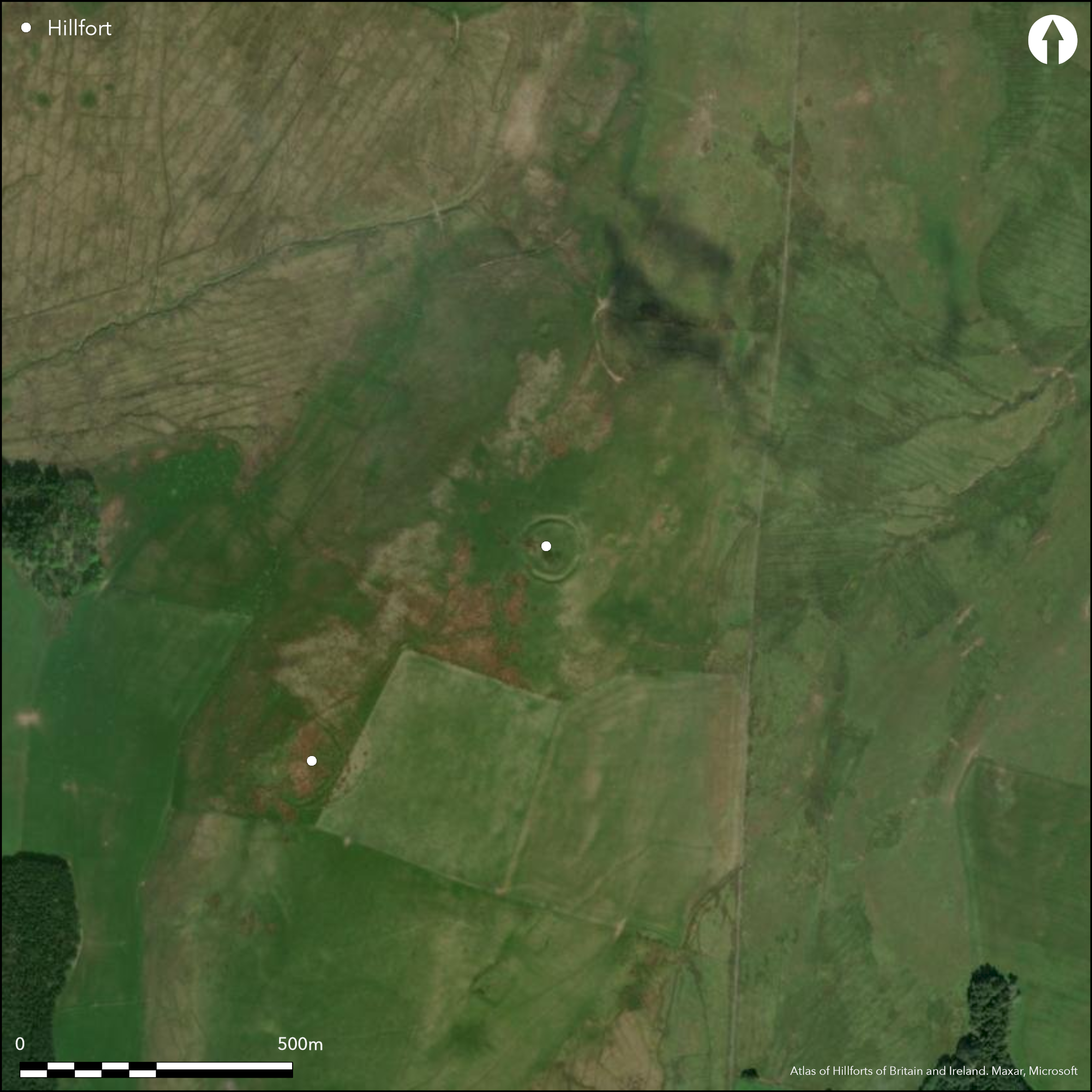
Satellite Imagery
LiDAR 1m DTM Hillshade
Satellite Imagery
Scroll left/right to view further images.
HER: Dumfries & Galloway MDG7350 (None)
NMR: NY 19 SW 9 (66973)
SM: 12660
NGR: NY 1310 9108
X: 313100 Y: 591080 (OSGB36)
Situated on the summit of the ridge known as Broomhillbank Hill, this fort is circular on plan and measures 49m in diameter within twin ramparts with a medial ditch. The inner and outer ramparts are up to 8m and 5m thick respectively and the inner is about 1m in height. The ditch between them is about 4m broad and there are also traces of an internal quarry scoop around the greater part of the circuit. There are entrances on the WNW and ESE, the latter mutilated by a later track which enters the ditch at this point and exits through the outer rampart on the NW. There are two well-defined round-houses within the interior, each of which measures about 11m in diameter over a shallow ditch.
Citizen Science: ✗
Reliability of Data: Confirmed
Reliability of Interpretation: Confirmed
X: -374820 Y: 7402014 (EPSG: 3857)
Longitude: -3.3670662785914165 Latitude: 55.20632833883412 (EPSG:4326)
Country: Scotland
Current County or Unitary Authority: Dumfries & Galloway
Historic County: Dumfriesshire
Current Parish/Community/Council/Townland: Applegarth
None
| Extant | ✓ |
| Cropmark | ✗ |
| Likely Destroyed | ✗ |
None
| Woodland | ✗ |
| Commercial Forestry Plantation | ✗ |
| Parkland | ✗ |
| Pasture (Grazing) | ✓ |
| Arable | ✗ |
| Scrub/Bracken | ✗ |
| Bare Outcrop | ✗ |
| Heather/Moorland | ✓ |
| Heath | ✗ |
| Built-up | ✗ |
| Coastal Grassland | ✗ |
| Other | ✗ |
None
| Contour Fort | ✓ |
| Partial Contour Fort | ✗ |
| Promontory Fort | ✗ |
| Hillslope Fort | ✗ |
| Level Terrain Fort | ✗ |
| Marsh Fort | ✗ |
| Multiple Enclosure Fort | ✗ |
| Hilltop | ✓ |
| Coastal Promontory | ✗ |
| Inland Promontory | ✗ |
| Valley Bottom | ✗ |
| Knoll/Hillock/Outcrop | ✗ |
| Ridge | ✗ |
| Cliff/Plateau-edge/Scarp | ✗ |
| Hillslope | ✗ |
| Lowland | ✗ |
| Spur | ✗ |
Dominant Topographic Feature: None
| North | ✗ |
| Northeast | ✗ |
| East | ✗ |
| Southeast | ✗ |
| South | ✗ |
| Southwest | ✗ |
| West | ✗ |
| Northwest | ✗ |
| Level | ✓ |
Altitude: 255.0m
N/A
In the absence of excavation, there are neither stratified artefacts nor radiocarbon dates to provide a chronology for the defences.
Reliability: D - None
| Pre 1200BC | ✗ |
| 1200BC - 800BC | ✗ |
| 800BC - 400BC | ✗ |
| 400BC - AD50 | ✗ |
| AD50 - AD400 | ✗ |
| AD400 - AD 800 | ✗ |
| Post AD800 | ✗ |
| Unknown | ✓ |
| Pre Hillfort: | None |
| Post Hillfort: | None |
First depicted in 1804 on William Crawford's Map of Dumfries-shire (1804), it was shown in more detail in 1857 on the 1st edition OS 25-inch map (Dumfriesshire 1861, sheet 34.9). The fort was described and sketch-planned about 1890 by David Christison (Christison 1891, 248-9, fig 25), and subsequently described by Alexander Curle in 1912 for the County Inventory of Dumfriesshire (RCAHMS 1920, 4, no.11). It was planned by George Jobey in 1969 (Jobey 1971, 87, fig 6) and re-surveyed by the OS at 1:2500 in 1971. RCAHMS returned to plan it in greater detail in 1990 (RCAHMS 1997, 127, fig 123) and it was Scheduled in 2010. The earthworks have been photographed from the air by CUCAP, the RCAHMS Aerial Survey Programme, and by Jane Brann of Dumfries and Galloway Council.
| 1st Identified Map Depiction (1804): | William Crawford |
| Other (1857): | Annotated Fort on the 1st edition OS 25-inch map (Dumfriesshire 1861, sheet 34.9) |
| Earthwork Survey (1890): | Description and sketch-plan by David Christison (1891, 248-9, fig 25) |
| Other (1912): | Description (RCAHMS 1920, 4, no.11) |
| Earthwork Survey (1969): | George Jobey (Copies in RCAHMS DFD 333/1-2 P/CO) |
| Other (1971): | Resurveyed at 1:2500 by the OS |
| Earthwork Survey (1990): | Plan and description (RCAHMS 1997, 127, fig 123; RCAHMS DC32360 and SC1346183 ) |
| Other (2010): | Scheduled |
Traces of at least two timber round-houses
None
| None | ✓ |
| Spring | ✗ |
| Stream | ✗ |
| Pool | ✗ |
| Flush | ✗ |
| Well | ✗ |
| Other | ✗ |
Ring-ditch houses
| No Known Features | ✗ |
| Round Stone Structures | ✗ |
| Rectangular Stone Structures | ✗ |
| Curvilinear Platforms | ✗ |
| Other Roundhouse Evidence | ✓ |
| Pits | ✗ |
| Quarry Hollows | ✗ |
| Other | ✗ |
None
| No Known Excavation | ✓ |
| Pits | ✗ |
| Postholes | ✗ |
| Roundhouses | ✗ |
| Rectangular Structures | ✗ |
| Roads/Tracks | ✗ |
| Quarry Hollows | ✗ |
| Other | ✗ |
| Nothing Found | ✗ |
None
| No Known Geophysics | ✓ |
| Pits | ✗ |
| Roundhouses | ✗ |
| Rectangular Structures | ✗ |
| Roads/Tracks | ✗ |
| Quarry Hollows | ✗ |
| Other | ✗ |
| Nothing Found | ✗ |
None
| No Known Finds | ✓ |
| Pottery | ✗ |
| Metal | ✗ |
| Metalworking | ✗ |
| Human Bones | ✗ |
| Animal Bones | ✗ |
| Lithics | ✗ |
| Environmental | ✗ |
| Other | ✗ |
None
| APs Not Checked | ✗ |
| None | ✗ |
| Roundhouses | ✓ |
| Rectangular Structures | ✗ |
| Pits | ✗ |
| Postholes | ✗ |
| Roads/Tracks | ✗ |
| Other | ✗ |
See main summary
| 2: | None |
| 2: | None |
Guard Chambers: ✗
Chevaux de Frise: ✗
| 1. Simple Gap (East): | None |
| 2. Simple Gap (West): | None |
Twin ramparts with a medial ditch
| Area 1: | 0.2ha. |
| Total: | 0.2ha. |
Total Footprint Area: 0.43ha.
None
| ✗ | None |
| ✓ | None |
| NE Quadrant: | 2 |
| SE Quadrant: | 2 |
| SW Quadrant: | 2 |
| NW Quadrant: | 2 |
| Total: | 2 |
| Partial Univallate | ✗ |
| Univallate | ✗ |
| Partial Bivallate | ✗ |
| Bivallate | ✓ |
| Partial Multivallate | ✗ |
| Multivallate | ✗ |
| Unknown | ✗ |
| Partial Univallate | ✗ |
| Univallate | ✗ |
| Partial Bivallate | ✗ |
| Bivallate | ✗ |
| Partial Multivallate | ✗ |
| Multivallate | ✗ |
None
| None | ✗ |
| Earthen Bank | ✓ |
| Stone Wall | ✗ |
| Rubble | ✗ |
| Wall-walk | ✗ |
| Evidence of Timber | ✗ |
| Vitrification | ✗ |
| Other Burning | ✗ |
| Palisade | ✗ |
| Counter Scarp Bank | ✗ |
| Berm | ✗ |
| Unfinished | ✗ |
| Other | ✗ |
None
| None | ✗ |
| Earthen Bank | ✗ |
| Stone Wall | ✗ |
| Murus Duplex | ✗ |
| Timber-framed | ✗ |
| Timber-laced | ✗ |
| Vitrification | ✗ |
| Other Burning | ✗ |
| Palisade | ✗ |
| Counter Scarp Bank | ✗ |
| Berm | ✗ |
| Unfinished | ✗ |
| No Known Excavation | ✓ |
| Other | ✗ |
| ✗ | None |
| ✓ | None |
Number of Ditches: 1
| ✗ | None |
Christison, D (1891) 'A general view of the forts, camps, and motes of Dumfriesshire, with a detailed description of those in Upper Annandale, and an introduction to the study of Scottish motes', Proc Soc Antiq Scot 25 (1890-91), 198-256
Feachem, R (1963) A guide to prehistoric Scotland, London (p 116)
Jobey, G (1971) 'Early settlements in eastern Dumfriesshire'. Trans Dumfriesshire Galloway Natur Hist Antiq Soc, 3 Ser, 48 (1971), 78-105
RCAHMS (1920) The Royal Commission on the Ancient and Historical Monuments of Scotland. Seventh Report with Inventory of Monuments and Constructions in the County of Dumfries. HMSO: Edinburgh
RCAHMS (1997) Royal Commission on the Ancient and Historical Monuments of Scotland. Eastern Dumfriesshire: an archaeological landscape. HMSO: Edinburgh
Atlas of Hillforts:
Wikidata:
This work is licensed under CC BY-SA 4.0![]()
![]()
![]() and should be cited as:
and should be cited as:
Lock, Gary and Ralston, Ian. 2024. Atlas of Hillforts of Britain and Ireland. Available at: https://hillforts.arch.ox.ac.uk
Document Version 1.1