LiDAR 1m DTM Hillshade

Satellite Imagery
LiDAR 1m DTM Hillshade
Satellite Imagery
Scroll left/right to view further images.
HER: Dumfries & Galloway MDG7555 (None)
NMR: NY 28 SW 6 (67226)
SM: 3963
NGR: NY 2380 8371
X: 323805 Y: 583719 (OSGB36)
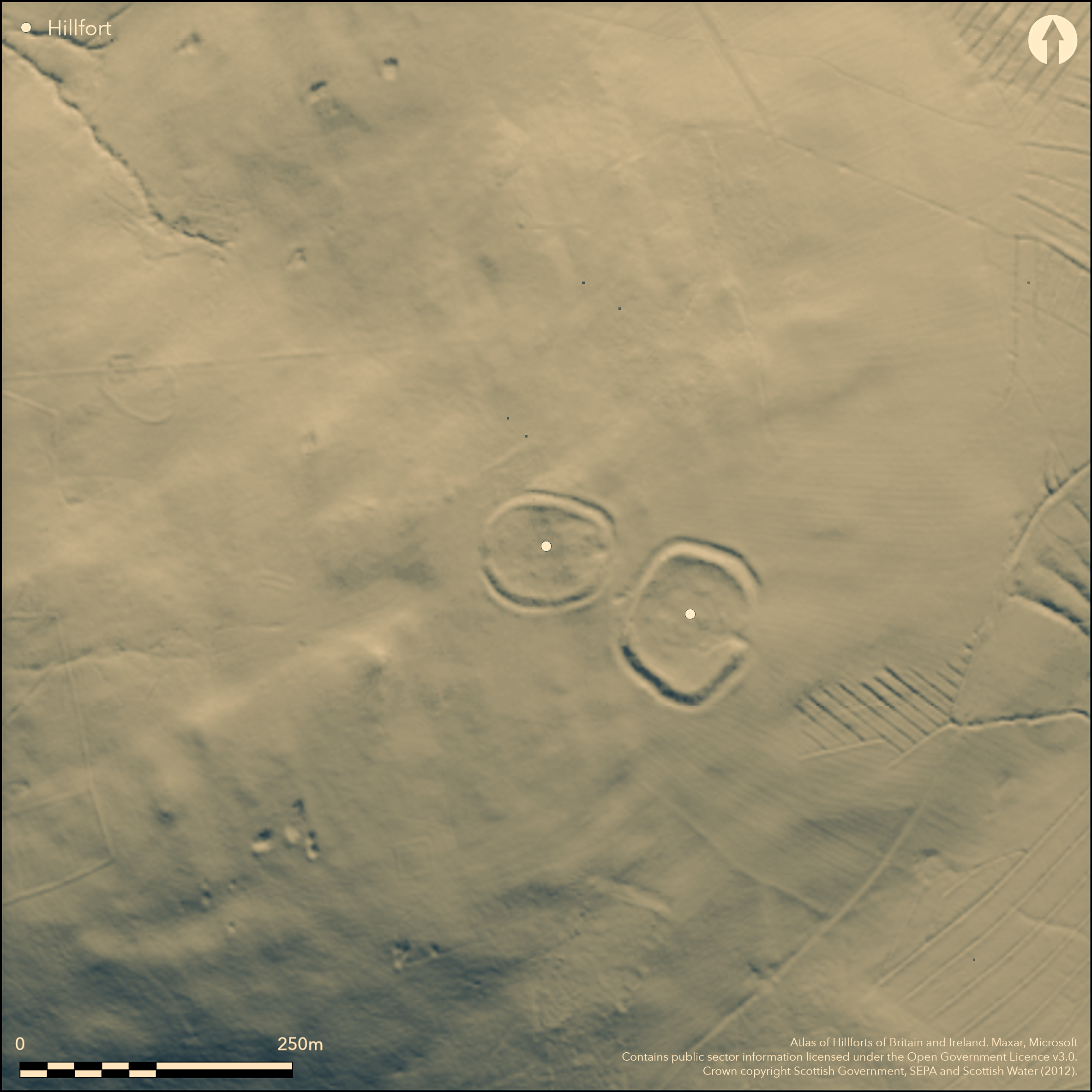
This fortified settlement is situated on the shoulder of the broad rounded summit of Newhall Hill, lying immediately NW of a second fortified settlement (Atlas No.1038) on the slope below the shoulder. Oval on plan, it measures 60m from E to W by 48m transversely within a rampart with a partly rock-cut external ditch and a low counterscarp bank, and there are entrances on the E and W respectively. The rampart is up to 5m in thickness, and while it is not particularly high internally, it stands some 1.5m above the bottom of the ditch, which is up to 5m in breadth by 1m in depth where it has been cut through rock on the N, but barely visible on the NW. In 1912 Alexander Curle noted stones set up on end in an exposure in the crest of the rampart on the S (RCAHMS 1920, 205-6, no.601), possibly indicating the presence of a palisade set into the top of the rampart. On the N, however, there are also traces of an earlier palisade trench, which loops out from beneath the counterscarp bank over a distance of about 25m and appears to have enclosed the low rise that forms the very summit of the hill, though no evidence of it can be seen within the featureless interior.
Citizen Science: ✗
Reliability of Data: Confirmed
Reliability of Interpretation: Confirmed
X: -355878 Y: 7389468 (EPSG: 3857)
Longitude: -3.1969105927809722 Latitude: 55.14196505214044 (EPSG:4326)
Country: Scotland
Current County or Unitary Authority: Dumfries & Galloway
Historic County: Dumfriesshire
Current Parish/Community/Council/Townland: Tundergarth
None
| Extant | ✓ |
| Cropmark | ✗ |
| Likely Destroyed | ✗ |
None
| Woodland | ✗ |
| Commercial Forestry Plantation | ✗ |
| Parkland | ✗ |
| Pasture (Grazing) | ✓ |
| Arable | ✗ |
| Scrub/Bracken | ✗ |
| Bare Outcrop | ✗ |
| Heather/Moorland | ✗ |
| Heath | ✗ |
| Built-up | ✗ |
| Coastal Grassland | ✗ |
| Other | ✗ |
None
| Contour Fort | ✓ |
| Partial Contour Fort | ✗ |
| Promontory Fort | ✗ |
| Hillslope Fort | ✗ |
| Level Terrain Fort | ✗ |
| Marsh Fort | ✗ |
| Multiple Enclosure Fort | ✗ |
| Hilltop | ✓ |
| Coastal Promontory | ✗ |
| Inland Promontory | ✗ |
| Valley Bottom | ✗ |
| Knoll/Hillock/Outcrop | ✗ |
| Ridge | ✗ |
| Cliff/Plateau-edge/Scarp | ✗ |
| Hillslope | ✗ |
| Lowland | ✗ |
| Spur | ✗ |
Dominant Topographic Feature: None
| North | ✗ |
| Northeast | ✗ |
| East | ✗ |
| Southeast | ✗ |
| South | ✗ |
| Southwest | ✗ |
| West | ✗ |
| Northwest | ✗ |
| Level | ✓ |
Altitude: 260.0m
N/A
In the absence of excavation, there are neither stratified artefacts nor radiocarbon dates to provide a chronology for the defences.
Reliability: D - None
| Pre 1200BC | ✗ |
| 1200BC - 800BC | ✗ |
| 800BC - 400BC | ✗ |
| 400BC - AD50 | ✗ |
| AD50 - AD400 | ✗ |
| AD400 - AD 800 | ✗ |
| Post AD800 | ✗ |
| Unknown | ✓ |
| Pre Hillfort: | Earlier palisaded enclosure |
| Post Hillfort: | None |
First depicted in 1857 on the 1st edition OS 25-inch map (Dumfriesshire 1862, sheets 44.10 & 44.14), it was described in 1912 by Alexander Curle during the preparation of the County Inventory for Dumfriesshire (RCAHMS 1920, 205-6, no.601). It was surveyed in late 1967 by George Jobey as part of his work in eastern Dumfriesshire (Jobey 1971), and resurveyed by the OS at 1:2500 in 1970, and revisited in 1979. It was Scheduled in 1977. The earlier palisade was first recognised when RCAHMS revisited the site in 1993 (RCAHMS 1997, 126).
| 1st Identified Map Depiction (1857): | Annotated Forts on the 1st edition OS 25-inch map (Dumfriesshire 1862, sheets 44.10 & 44.14) |
| Other (1912): | Description (RCAHMS 1920, 205-6, no.601) |
| Earthwork Survey (1967): | George Jobey (copies in RCAHMS DFD 351/1-4 P/CO) |
| Other (1970): | Resurveyed at 1:2500 by the OS |
| Other (1977): | Scheduled |
| Other (1979): | Surveyed at 1:10.000 by the OS |
| Other (1993): | Description by RCAHMS |
Featureless
None
| None | ✓ |
| Spring | ✗ |
| Stream | ✗ |
| Pool | ✗ |
| Flush | ✗ |
| Well | ✗ |
| Other | ✗ |
None
| No Known Features | ✓ |
| Round Stone Structures | ✗ |
| Rectangular Stone Structures | ✗ |
| Curvilinear Platforms | ✗ |
| Other Roundhouse Evidence | ✗ |
| Pits | ✗ |
| Quarry Hollows | ✗ |
| Other | ✗ |
None
| No Known Excavation | ✓ |
| Pits | ✗ |
| Postholes | ✗ |
| Roundhouses | ✗ |
| Rectangular Structures | ✗ |
| Roads/Tracks | ✗ |
| Quarry Hollows | ✗ |
| Other | ✗ |
| Nothing Found | ✗ |
None
| No Known Geophysics | ✓ |
| Pits | ✗ |
| Roundhouses | ✗ |
| Rectangular Structures | ✗ |
| Roads/Tracks | ✗ |
| Quarry Hollows | ✗ |
| Other | ✗ |
| Nothing Found | ✗ |
None
| No Known Finds | ✓ |
| Pottery | ✗ |
| Metal | ✗ |
| Metalworking | ✗ |
| Human Bones | ✗ |
| Animal Bones | ✗ |
| Lithics | ✗ |
| Environmental | ✗ |
| Other | ✗ |
NO APPARENT FEATURES
| APs Not Checked | ✗ |
| None | ✓ |
| Roundhouses | ✗ |
| Rectangular Structures | ✗ |
| Pits | ✗ |
| Postholes | ✗ |
| Roads/Tracks | ✗ |
| Other | ✗ |
See main summary
| 2: | None |
| 2: | None |
Guard Chambers: ✗
Chevaux de Frise: ✗
| 1. Simple Gap (East): | None |
| 2. Simple Gap (West): | None |
Single rampart and ditch with low counterscarp
| Area 1: | 0.23ha. |
| Total: | 0.23ha. |
Total Footprint Area: 0.4ha.
None
| ✓ | None |
| ✓ | None |
| NE Quadrant: | 1 |
| SE Quadrant: | 1 |
| SW Quadrant: | 1 |
| NW Quadrant: | 1 |
| Total: | 1 |
| Partial Univallate | ✗ |
| Univallate | ✓ |
| Partial Bivallate | ✗ |
| Bivallate | ✗ |
| Partial Multivallate | ✗ |
| Multivallate | ✗ |
| Unknown | ✗ |
| Partial Univallate | ✗ |
| Univallate | ✗ |
| Partial Bivallate | ✗ |
| Bivallate | ✗ |
| Partial Multivallate | ✗ |
| Multivallate | ✗ |
Earlier palisade
| None | ✗ |
| Earthen Bank | ✓ |
| Stone Wall | ✗ |
| Rubble | ✗ |
| Wall-walk | ✗ |
| Evidence of Timber | ✗ |
| Vitrification | ✗ |
| Other Burning | ✗ |
| Palisade | ✓ |
| Counter Scarp Bank | ✓ |
| Berm | ✗ |
| Unfinished | ✗ |
| Other | ✗ |
None
| None | ✗ |
| Earthen Bank | ✗ |
| Stone Wall | ✗ |
| Murus Duplex | ✗ |
| Timber-framed | ✗ |
| Timber-laced | ✗ |
| Vitrification | ✗ |
| Other Burning | ✗ |
| Palisade | ✗ |
| Counter Scarp Bank | ✗ |
| Berm | ✗ |
| Unfinished | ✗ |
| No Known Excavation | ✓ |
| Other | ✗ |
| ✗ | None |
| ✓ | None |
Number of Ditches: 1
| ✗ | None |
Jobey, G (1971) 'Early settlements in eastern Dumfriesshire'. Trans Dumfriesshire Galloway Natur Hist Antiq Soc, 3 Ser, 48 (1971), 78-105
RCAHMS (1920) The Royal Commission on the Ancient and Historical Monuments of Scotland. Seventh Report with Inventory of Monuments and Constructions in the County of Dumfries. HMSO: Edinburgh
RCAHMS (1997) Royal Commission on the Ancient and Historical Monuments of Scotland. Eastern Dumfriesshire: an archaeological landscape. HMSO: Edinburgh
Atlas of Hillforts:
Wikidata:
This work is licensed under CC BY-SA 4.0![]()
![]()
![]() and should be cited as:
and should be cited as:
Lock, Gary and Ralston, Ian. 2024. Atlas of Hillforts of Britain and Ireland. Available at: https://hillforts.arch.ox.ac.uk
Document Version 1.1