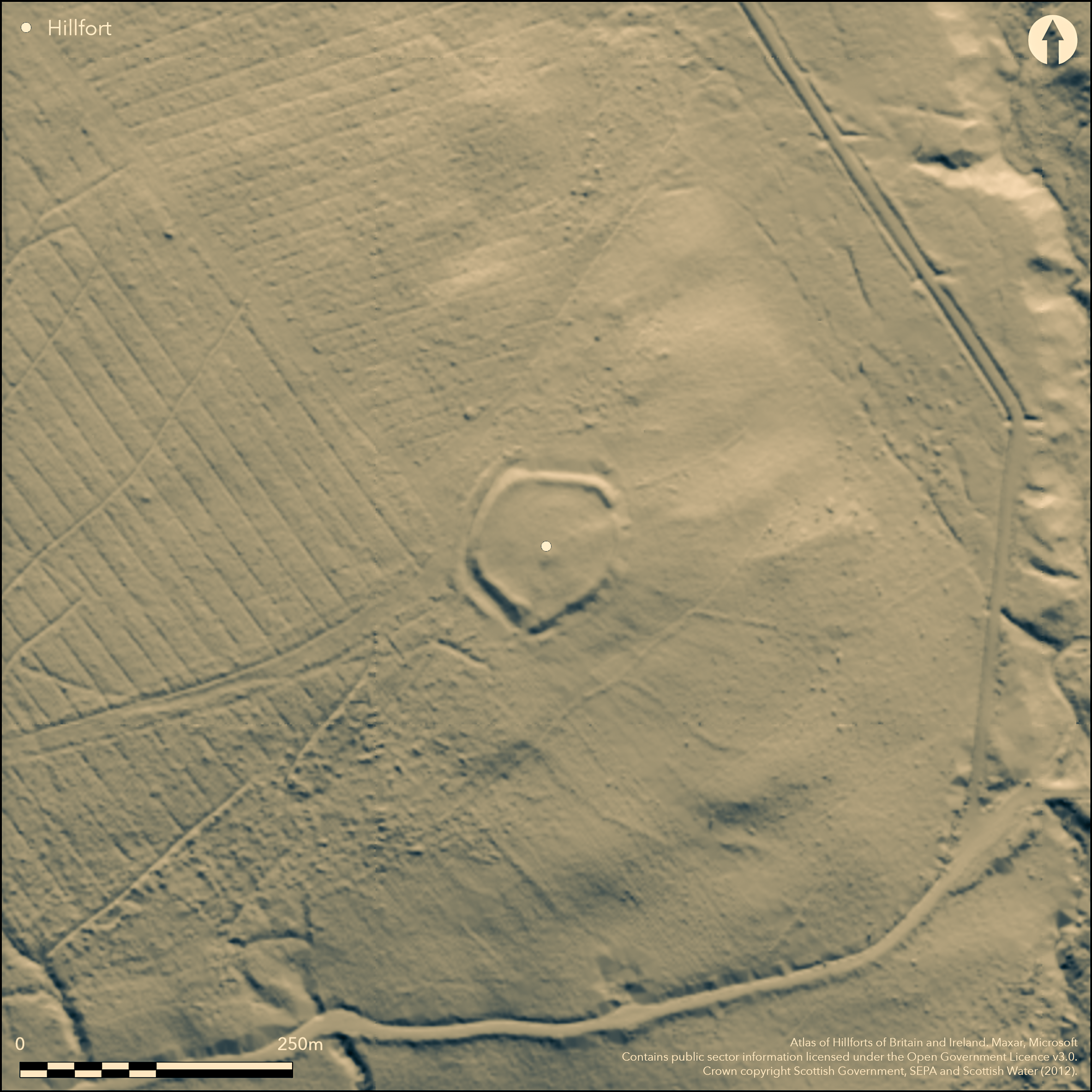
LiDAR 1m DTM Hillshade
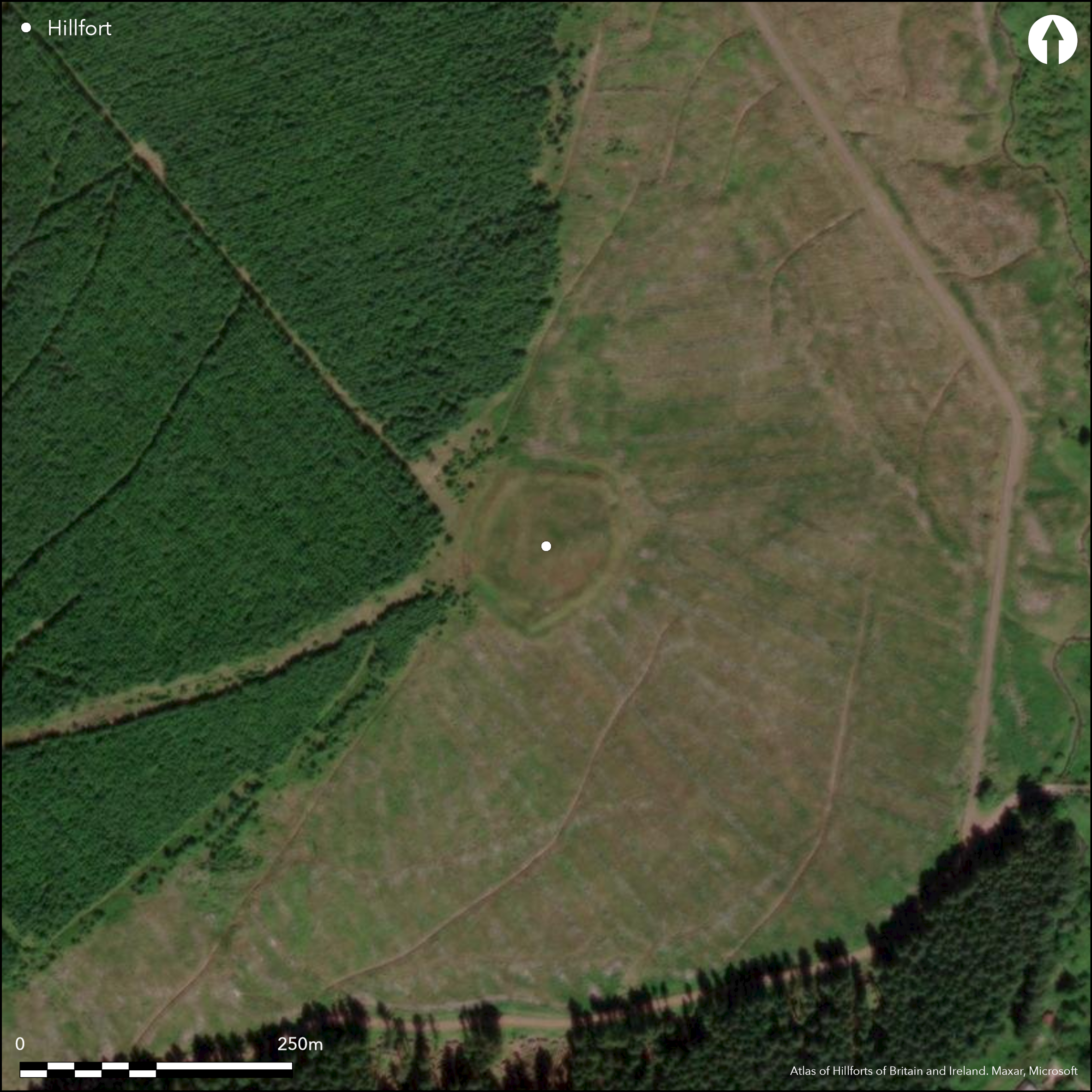
Satellite Imagery
LiDAR 1m DTM Hillshade
Satellite Imagery
Scroll left/right to view further images.
HER: Dumfries & Galloway MDG7632 (None)
NMR: NY 29 SE 10 (67304)
SM: 4333
NGR: NY 2648 9276
X: 326489 Y: 592760 (OSGB36)
This fortified settlement is situated on the gently sloping SE flank of Bank Head Hill, just above the point where the ground falls away more steeply to the Bankhead Burn. Subcircular on plan, with marked angles on the N and W, it measures about 65m in diameter (0.35ha) within twin ramparts with a medial ditch. The inner rampart is up to 6m in thickness on the NW, uphill side, where it stands 2.4m high above the bottom of the ditch, which is itself about 6m in breadth. The entrance is on the ENE, opening into a shallow hollow within the interior, and George Jobey's plan (1971, 90, fig 10) suggests the presence of two shallow house platforms cut into the slope at the back of the interior on the NW. A second gap in the defences on the SSW may be more recent, possibly relating to when it was incorporated into a post-medieval field-system, now largely obliterated by forestry on the surrounding slopes; traces of one field bank can be seen crossing the ditch on the N, while another apparently crowns the inner rampart on the NW and SW, probably accounting for the 'suggestion of stonework on its sharp narrow crest' observed by Alexander Curle in 1912 (RCAHMS 1920, 214, no.634) .
Citizen Science: ✗
Reliability of Data: Confirmed
Reliability of Interpretation: Confirmed
X: -351454 Y: 7405383 (EPSG: 3857)
Longitude: -3.1571642952685623 Latitude: 55.22359769589901 (EPSG:4326)
Country: Scotland
Current County or Unitary Authority: Dumfries & Galloway
Historic County: Dumfriesshire
Current Parish/Community/Council/Townland: Westerkirk
None
| Extant | ✓ |
| Cropmark | ✗ |
| Likely Destroyed | ✗ |
Clearing in a forestry plantation
| Woodland | ✗ |
| Commercial Forestry Plantation | ✓ |
| Parkland | ✗ |
| Pasture (Grazing) | ✗ |
| Arable | ✗ |
| Scrub/Bracken | ✗ |
| Bare Outcrop | ✗ |
| Heather/Moorland | ✓ |
| Heath | ✗ |
| Built-up | ✗ |
| Coastal Grassland | ✗ |
| Other | ✗ |
None
| Contour Fort | ✗ |
| Partial Contour Fort | ✗ |
| Promontory Fort | ✗ |
| Hillslope Fort | ✓ |
| Level Terrain Fort | ✗ |
| Marsh Fort | ✗ |
| Multiple Enclosure Fort | ✗ |
| Hilltop | ✗ |
| Coastal Promontory | ✗ |
| Inland Promontory | ✗ |
| Valley Bottom | ✗ |
| Knoll/Hillock/Outcrop | ✗ |
| Ridge | ✗ |
| Cliff/Plateau-edge/Scarp | ✗ |
| Hillslope | ✓ |
| Lowland | ✗ |
| Spur | ✗ |
Dominant Topographic Feature: None
| North | ✗ |
| Northeast | ✗ |
| East | ✗ |
| Southeast | ✓ |
| South | ✗ |
| Southwest | ✗ |
| West | ✗ |
| Northwest | ✗ |
| Level | ✗ |
Altitude: 213.0m
N/A
In the absence of excavation, there are neither stratified artefacts nor radiocarbon dates to provide a chronology for the defences.
Reliability: D - None
| Pre 1200BC | ✗ |
| 1200BC - 800BC | ✗ |
| 800BC - 400BC | ✗ |
| 400BC - AD50 | ✗ |
| AD50 - AD400 | ✗ |
| AD400 - AD 800 | ✗ |
| Post AD800 | ✗ |
| Unknown | ✓ |
| Pre Hillfort: | None |
| Post Hillfort: | Overlain by post-medieval field-banks |
First depicted in 1804 on William Crawford's Map of Dumfriesshire, in 1857 it was surveyed for the 1st edition OS 25-inch map (Dumfiresshire 1862, sheet 35.7), and in 1912 visited by Alexander Curle during the preparation of the County Inventory for Dumfriesshire (RCAHMS 1920, 214, no.634), it was revisited by RCAHMS in 1955 and later again in 1980. George Jobey surveyed the earthworks in the late 1960s, and the OS resurveyed at 1:2500 in 1973, revisiting in 1978. It was first Scheduled in 1981 and re-Scheduled with a larger area in 2010.
| 1st Identified Map Depiction (1804): | Depicted on William Crawford's Map of Dumfriesshire (1804) |
| Other (1857): | Annotated Fort on the 1st edition OS 25-inch map (Dumfiresshire 1862, sheet 35.7) |
| Other (1912): | Description (RCAHMS 1920, 214, no.634) |
| Other (1955): | Description for RCAHMS Survey of Marginal Lands |
| Earthwork Survey (1971): | George Jobey (Copies in RCAHMS DFD 268/1-3 P/CO) |
| Other (1973): | Resurveyed at 1:2500 by the OS |
| Other (1978): | Surveyed at 1:10.000 by the OS |
| Other (1980): | Description by RCAHMS |
| Other (1981): | Scheduled |
| Other (2010): | Re-Scheduled |
Two shallow scoops in the slope on the NW side of the interior are probably house platforms
None
| None | ✓ |
| Spring | ✗ |
| Stream | ✗ |
| Pool | ✗ |
| Flush | ✗ |
| Well | ✗ |
| Other | ✗ |
None
| No Known Features | ✗ |
| Round Stone Structures | ✗ |
| Rectangular Stone Structures | ✗ |
| Curvilinear Platforms | ✓ |
| Other Roundhouse Evidence | ✗ |
| Pits | ✗ |
| Quarry Hollows | ✗ |
| Other | ✗ |
None
| No Known Excavation | ✓ |
| Pits | ✗ |
| Postholes | ✗ |
| Roundhouses | ✗ |
| Rectangular Structures | ✗ |
| Roads/Tracks | ✗ |
| Quarry Hollows | ✗ |
| Other | ✗ |
| Nothing Found | ✗ |
None
| No Known Geophysics | ✓ |
| Pits | ✗ |
| Roundhouses | ✗ |
| Rectangular Structures | ✗ |
| Roads/Tracks | ✗ |
| Quarry Hollows | ✗ |
| Other | ✗ |
| Nothing Found | ✗ |
None
| No Known Finds | ✓ |
| Pottery | ✗ |
| Metal | ✗ |
| Metalworking | ✗ |
| Human Bones | ✗ |
| Animal Bones | ✗ |
| Lithics | ✗ |
| Environmental | ✗ |
| Other | ✗ |
NO APPARENT FEATURES
| APs Not Checked | ✗ |
| None | ✓ |
| Roundhouses | ✗ |
| Rectangular Structures | ✗ |
| Pits | ✗ |
| Postholes | ✗ |
| Roads/Tracks | ✗ |
| Other | ✗ |
See main summary
| 2: | The OS thought the gap on the SSW was caused by an old trackway |
| 2: | None |
Guard Chambers: ✗
Chevaux de Frise: ✗
| 1. Simple Gap (North east): | None |
Rampart with ditch and intermittent counterscarp bank
| Area 1: | 0.35ha. |
| Total: | 0.35ha. |
Total Footprint Area: 0.7ha.
None
| ✗ | None |
| ✓ | None |
| NE Quadrant: | 1 |
| SE Quadrant: | 1 |
| SW Quadrant: | 1 |
| NW Quadrant: | 1 |
| Total: | 1 |
| Partial Univallate | ✗ |
| Univallate | ✓ |
| Partial Bivallate | ✗ |
| Bivallate | ✗ |
| Partial Multivallate | ✗ |
| Multivallate | ✗ |
| Unknown | ✗ |
| Partial Univallate | ✗ |
| Univallate | ✗ |
| Partial Bivallate | ✗ |
| Bivallate | ✗ |
| Partial Multivallate | ✗ |
| Multivallate | ✗ |
None
| None | ✗ |
| Earthen Bank | ✓ |
| Stone Wall | ✗ |
| Rubble | ✗ |
| Wall-walk | ✗ |
| Evidence of Timber | ✗ |
| Vitrification | ✗ |
| Other Burning | ✗ |
| Palisade | ✗ |
| Counter Scarp Bank | ✓ |
| Berm | ✗ |
| Unfinished | ✗ |
| Other | ✗ |
None
| None | ✗ |
| Earthen Bank | ✗ |
| Stone Wall | ✗ |
| Murus Duplex | ✗ |
| Timber-framed | ✗ |
| Timber-laced | ✗ |
| Vitrification | ✗ |
| Other Burning | ✗ |
| Palisade | ✗ |
| Counter Scarp Bank | ✗ |
| Berm | ✗ |
| Unfinished | ✗ |
| No Known Excavation | ✓ |
| Other | ✗ |
| ✗ | None |
| ✓ | None |
Number of Ditches: 1
| ✗ | None |
Jobey, G (1971) 'Early settlements in eastern Dumfriesshire'. Trans Dumfriesshire Galloway Natur Hist Antiq Soc, 3 Ser, 48 (1971), 78-105
RCAHMS (1920) The Royal Commission on the Ancient and Historical Monuments of Scotland. Seventh Report with Inventory of Monuments and Constructions in the County of Dumfries. HMSO: Edinburgh
Atlas of Hillforts:
Wikidata:
This work is licensed under CC BY-SA 4.0![]()
![]()
![]() and should be cited as:
and should be cited as:
Lock, Gary and Ralston, Ian. 2024. Atlas of Hillforts of Britain and Ireland. Available at: https://hillforts.arch.ox.ac.uk
Document Version 1.1