LiDAR 1m DTM Hillshade
Satellite Imagery
LiDAR 1m DTM Hillshade
Satellite Imagery
Scroll left/right to view further images.
HER: Dumfries & Galloway MDG7700 (None)
NMR: NY 29 SE 8 (67373)
SM: 647
NGR: NY 2558 9052
X: 325580 Y: 590520 (OSGB36)
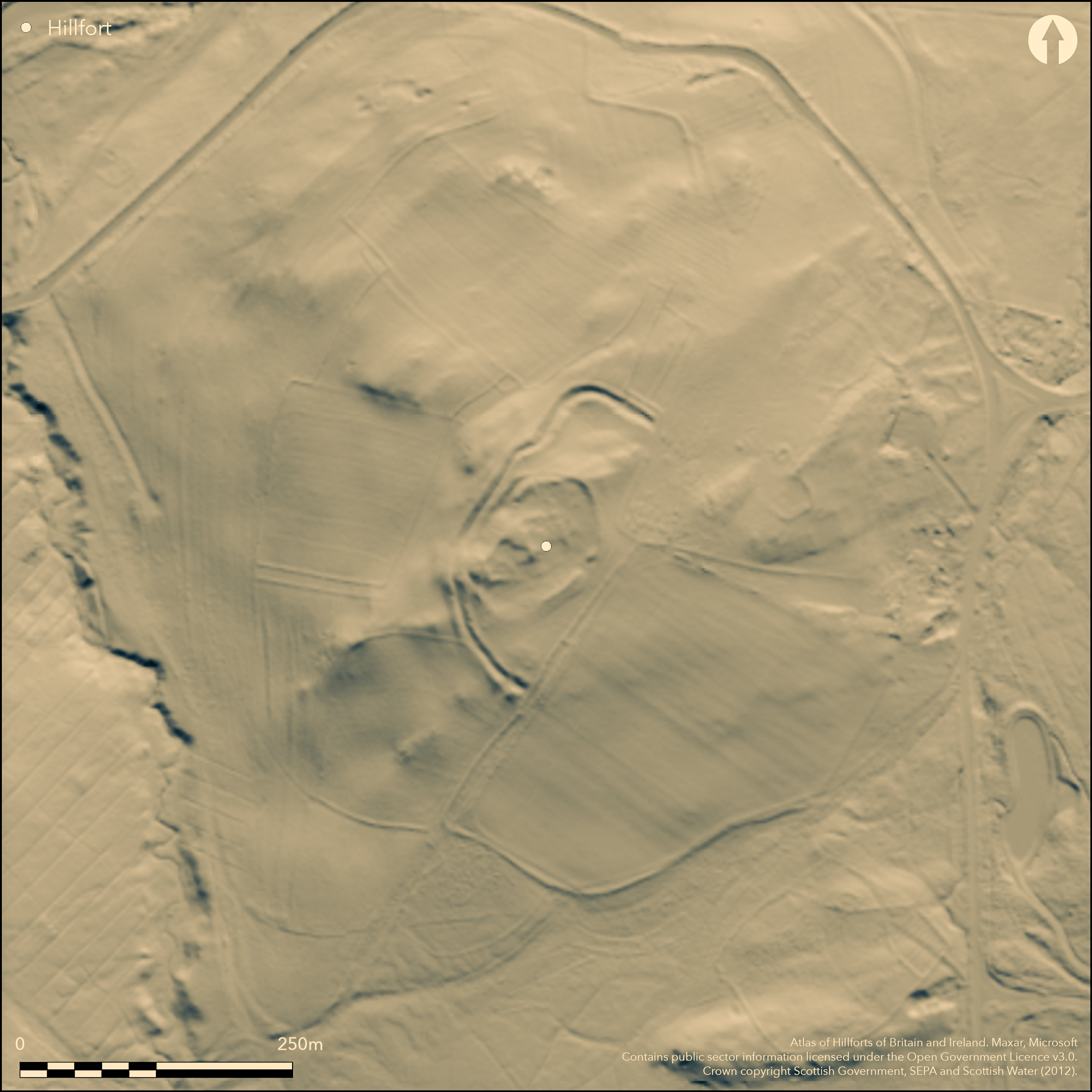
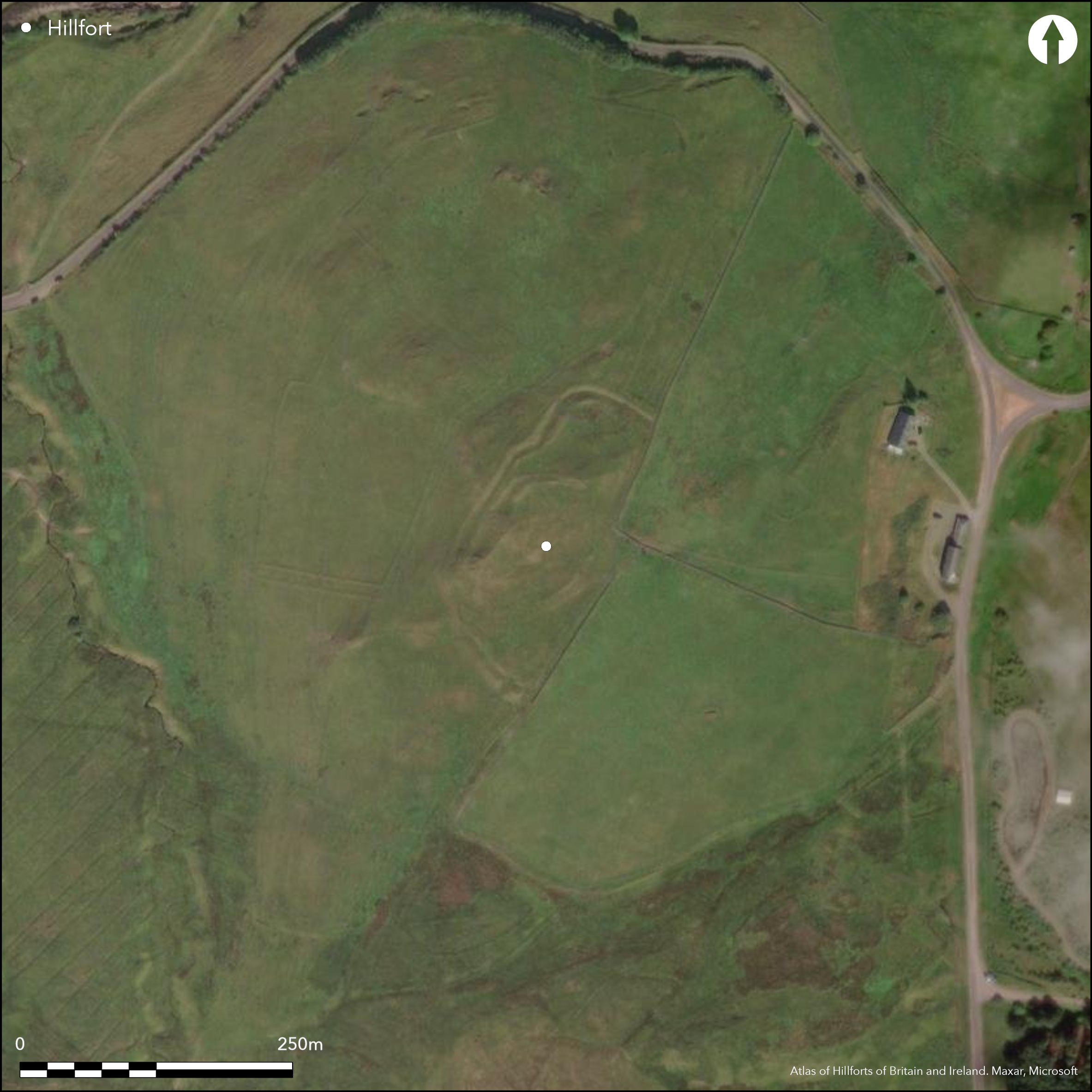
This fort is situated on Camp Hill and comprises a complex sequence of univallate fortifications occupying the hillock forming the summit, and a much larger outer enclosure contouring around a shoulder at a lower level. The earliest of the ramparts probably enclosed an area measuring about 78m from NNE to SSW by 50m transversely (0.34ha), though its course is largely masked around the SE half of the circuit by the latest, phase 3, line, which includes an entrance on the ESE. This rampart takes in a rather smaller area of about 0.26ha, but on the W overrides yet another line of vallation (phase 2). Now fragmentary, particularly where it is overlain by house platforms within the interior, this last encloses no more than 0.1ha on the summit, but was apparently accompanied by an external ditch, which can be seen cut into the rear of the surviving sector of the phase 1 rampart at the foot of the summit hillock on the W. Within the interior the stances of no fewer than 35 round-houses can be seen, mainly comprising platforms but including several with ring-grooves. None can be assigned to a specific phase, but their construction has virtually obliterated the line of the phase 2 rampart within the interior, while several others have been cut back into the phase 3 rampart. Whether this implies a phase of post-defensive open settlement, or possibly that the larger outer enclosure was itself a free-standing line of defence, is not known. The outer enclosure, which had been virtually ploughed out on the NE and SE by the middle of the 19th century, takes in an area measuring 143m from NNE to SSW by 114m transversely (1.3ha) within twin banks with a medial ditch about 5m in breadth; The position of its entrance is unknown, a break on the SSW being relatively modern.
Citizen Science: ✗
Reliability of Data: Confirmed
Reliability of Interpretation: Confirmed
X: -352979 Y: 7401430 (EPSG: 3857)
Longitude: -3.1708599346317725 Latitude: 55.20333687975176 (EPSG:4326)
Country: Scotland
Current County or Unitary Authority: Dumfries & Galloway
Historic County: Dumfriesshire
Current Parish/Community/Council/Townland: Westerkirk
None
| Extant | ✓ |
| Cropmark | ✗ |
| Likely Destroyed | ✓ |
None
| Woodland | ✗ |
| Commercial Forestry Plantation | ✗ |
| Parkland | ✗ |
| Pasture (Grazing) | ✓ |
| Arable | ✗ |
| Scrub/Bracken | ✗ |
| Bare Outcrop | ✗ |
| Heather/Moorland | ✗ |
| Heath | ✗ |
| Built-up | ✗ |
| Coastal Grassland | ✗ |
| Other | ✗ |
None
| Contour Fort | ✓ |
| Partial Contour Fort | ✗ |
| Promontory Fort | ✗ |
| Hillslope Fort | ✗ |
| Level Terrain Fort | ✗ |
| Marsh Fort | ✗ |
| Multiple Enclosure Fort | ✓ |
| Hilltop | ✓ |
| Coastal Promontory | ✗ |
| Inland Promontory | ✗ |
| Valley Bottom | ✗ |
| Knoll/Hillock/Outcrop | ✗ |
| Ridge | ✗ |
| Cliff/Plateau-edge/Scarp | ✗ |
| Hillslope | ✗ |
| Lowland | ✗ |
| Spur | ✗ |
Dominant Topographic Feature: None
| North | ✗ |
| Northeast | ✗ |
| East | ✗ |
| Southeast | ✗ |
| South | ✗ |
| Southwest | ✗ |
| West | ✗ |
| Northwest | ✗ |
| Level | ✓ |
Altitude: 235.0m
N/A
In the absence of excavation, there are neither stratified artefacts nor radiocarbon dates to provide a chronology for the defences.
Reliability: D - None
| Pre 1200BC | ✗ |
| 1200BC - 800BC | ✗ |
| 800BC - 400BC | ✗ |
| 400BC - AD50 | ✗ |
| AD50 - AD400 | ✗ |
| AD400 - AD 800 | ✗ |
| Post AD800 | ✗ |
| Unknown | ✓ |
| Pre Hillfort: | None |
| Post Hillfort: | Elements ploughed down in the post-medieval period, and a rectangular building platform has been inserted into the interior |
First depicted in 1804 on William Crawford's map of Dumfriesshire, in 1857 it was surveyed for the 1st edition OS 25-inch map (Dumfriesshire 1862, sheet 35.10). The fort was described in 1912 by Alexander Curle during the preparation of the County Inventory for Dumfriesshire (RCAHMS 1920, 216-7, no.640). It was first Scheduled in 1937 (and re-Scheduled in 2010) and in 1955 revisited by RCAHMS investigators, who suggested it comprised a citadel with an outer ward, though while Kenneth Steer suspected an early medieval date, Richard Feachem variously saw no reason to think that it was not all Iron Age in date (Feachem 1965, 180-2), or that perhaps the inner enclosure was an early medieval insertion into a large Iron Age fort (Feachem 1963, 115). George Jobey adapted a copy of the OS 1:10,560 map to draw up a plan in the late 1960s (Jobey 1971, 83, fig 4), and it was resurveyed at 1:2500 by the OS in 1973, and revisited in 1978. RCAHMS drew upa new plan in 1993 (RCAHMS 1997, 81, fig 74). It was photographed from the air by CUCAP in 1972 and RCAHMS in 1996.
| 1st Identified Map Depiction (1804): | William Crawford. Map of Dumfriesshire (1804) |
| Other (1857): | Annotated Fort on the 1st edition OS 25-inch map (Dumfriesshire 1862, sheet 35.10) |
| Other (1912): | Description (RCAHMS 1920, 216-7, no.640) |
| Other (1937): | Scheduled |
| Other (1955): | Description during RCAHMS Survey of Marginal Lands |
| Earthwork Survey (1971): | George Jobey (Copy in RCAHMS DFD 267/1-3 P/CO) |
| Other (1973): | Resurveyed at 1:2500 by the OS |
| Other (1978): | Surveyed at 1:10.000 by the OS |
| Earthwork Survey (1993): | Plan and description initially surveyed 1991 (RCAHMS 1997, 81, fig 74; RCAHMS DC32431 & SC 1352379; DC32536 & SC372195 ) |
| Other (2010): | Re-Scheduled |
The sites of at least 35 timber round houses, comprising platforms and ring-grooves, can be seen within the interior; there is also one rectangular platform
None
| None | ✓ |
| Spring | ✗ |
| Stream | ✗ |
| Pool | ✗ |
| Flush | ✗ |
| Well | ✗ |
| Other | ✗ |
Rectangular platform. Ring-grooves
| No Known Features | ✗ |
| Round Stone Structures | ✗ |
| Rectangular Stone Structures | ✗ |
| Curvilinear Platforms | ✓ |
| Other Roundhouse Evidence | ✓ |
| Pits | ✗ |
| Quarry Hollows | ✗ |
| Other | ✓ |
None
| No Known Excavation | ✓ |
| Pits | ✗ |
| Postholes | ✗ |
| Roundhouses | ✗ |
| Rectangular Structures | ✗ |
| Roads/Tracks | ✗ |
| Quarry Hollows | ✗ |
| Other | ✗ |
| Nothing Found | ✗ |
None
| No Known Geophysics | ✓ |
| Pits | ✗ |
| Roundhouses | ✗ |
| Rectangular Structures | ✗ |
| Roads/Tracks | ✗ |
| Quarry Hollows | ✗ |
| Other | ✗ |
| Nothing Found | ✗ |
None
| No Known Finds | ✓ |
| Pottery | ✗ |
| Metal | ✗ |
| Metalworking | ✗ |
| Human Bones | ✗ |
| Animal Bones | ✗ |
| Lithics | ✗ |
| Environmental | ✗ |
| Other | ✗ |
None
| APs Not Checked | ✗ |
| None | ✗ |
| Roundhouses | ✓ |
| Rectangular Structures | ✓ |
| Pits | ✗ |
| Postholes | ✗ |
| Roads/Tracks | ✗ |
| Other | ✗ |
See main summary
| 3: | Ploughed down on the S and minor recent breaks in the NW sector |
| 2: | Single entrance visible in the final phase defences on the ESE |
Guard Chambers: ✗
Chevaux de Frise: ✗
| 1. Simple Gap (South east): | None |
Compex sequence of univallate perimeters, with large outer enclosure or annexe
| Area 1: | 0.26ha. |
| Area 2: | 0.34ha. |
| Area 3: | 1.3ha. |
| Total: | 1.3ha. |
Total Footprint Area: 1.7ha.
None
| ✓ | None |
| ✓ | None |
| NE Quadrant: | 1 |
| SE Quadrant: | 1 |
| SW Quadrant: | 1 |
| NW Quadrant: | 1 |
| Total: | 1 |
| Partial Univallate | ✗ |
| Univallate | ✓ |
| Partial Bivallate | ✗ |
| Bivallate | ✗ |
| Partial Multivallate | ✗ |
| Multivallate | ✗ |
| Unknown | ✗ |
| Partial Univallate | ✗ |
| Univallate | ✗ |
| Partial Bivallate | ✗ |
| Bivallate | ✓ |
| Partial Multivallate | ✗ |
| Multivallate | ✗ |
Essentially univallate in all phases, but the outer enclosure, nominally an annexe, has a counterscarp bank
| None | ✗ |
| Earthen Bank | ✓ |
| Stone Wall | ✗ |
| Rubble | ✗ |
| Wall-walk | ✗ |
| Evidence of Timber | ✗ |
| Vitrification | ✗ |
| Other Burning | ✗ |
| Palisade | ✗ |
| Counter Scarp Bank | ✓ |
| Berm | ✗ |
| Unfinished | ✗ |
| Other | ✗ |
None
| None | ✗ |
| Earthen Bank | ✗ |
| Stone Wall | ✗ |
| Murus Duplex | ✗ |
| Timber-framed | ✗ |
| Timber-laced | ✗ |
| Vitrification | ✗ |
| Other Burning | ✗ |
| Palisade | ✗ |
| Counter Scarp Bank | ✗ |
| Berm | ✗ |
| Unfinished | ✗ |
| No Known Excavation | ✓ |
| Other | ✗ |
| ✗ | None |
| ✓ | Only in the annexe enclosure, which comprises twin banks with a medial ditch. |
Number of Ditches: 1
| ✓ | In contrast to the threefold sequence of univallate enclosures on the summit of the hill, an outer enclosure bounded by twin banks with a medial ditch takes in an overall area of 1.3ha. Although the inner of the two banks adopts the line of the phase 1 rampart along the NW flank of the fort, its precise position in the sequence is unknown; nor is it known whether it was originally conceived as an annexe or a free-standing fortification. |
Feachem, R (1963b) A guide to prehistoric Scotland. Batsford: London
Feachem, R (1965) The North Britons: the prehistory of a Border people. Hutchinson: London
Jobey, G (1971) 'Early settlements in eastern Dumfriesshire'. Trans Dumfriesshire Galloway Natur Hist Antiq Soc, 3 Ser, 48 (1971), 78-105
RCAHMS (1920) The Royal Commission on the Ancient and Historical Monuments of Scotland. Seventh Report with Inventory of Monuments and Constructions in the County of Dumfries. HMSO: Edinburgh
RCAHMS (1997) Eastern Dumfriesshire: an archaeological landscape. HMSO: Edinburgh
Atlas of Hillforts:
Wikidata:
This work is licensed under CC BY-SA 4.0![]()
![]()
![]() and should be cited as:
and should be cited as:
Lock, Gary and Ralston, Ian. 2024. Atlas of Hillforts of Britain and Ireland. Available at: https://hillforts.arch.ox.ac.uk
Document Version 1.1