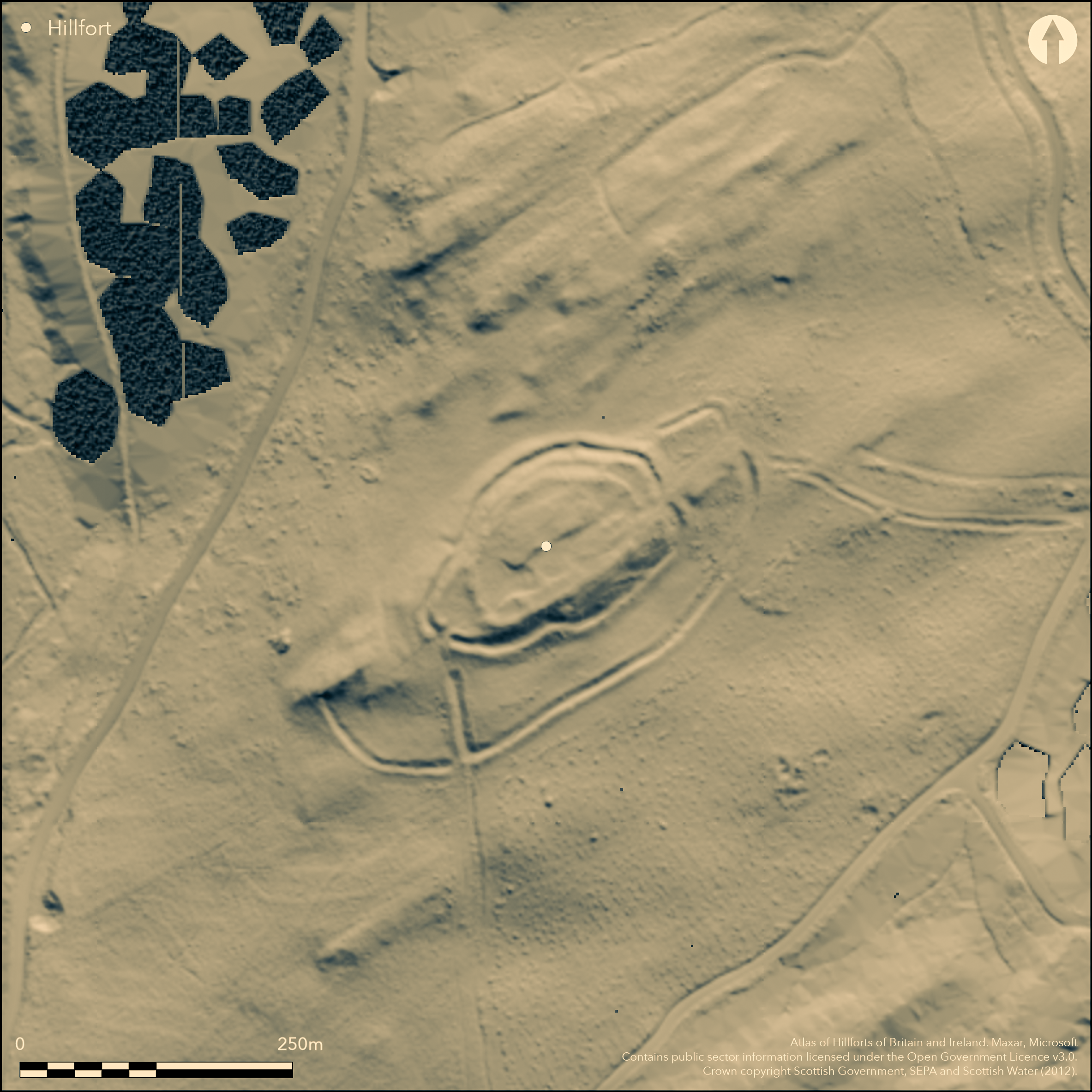
LiDAR 1m DTM Hillshade

Satellite Imagery
LiDAR 1m DTM Hillshade
Satellite Imagery
Scroll left/right to view further images.
HER: Dumfries & Galloway MDG7703 (None)
NMR: NY 29 SW 10 (67376)
SM: 651
NGR: NY 2419 9285
X: 324190 Y: 592850 (OSGB36)
This fort, which crowns the summit of Castle O'er Hill, displays evidence of at least two major phases of fortification and has a large annexe on its SE side. In its first phase it was an irregular oval on plan, measuring a maximum of 125m from ENE to WSW by 60m transversely (0.6ha) within twin ramparts with a medial ditch, which have been deployed to enhance the natural topography, particularly on the precipitous SE flank, where the inner rampart follows the crest of the slope, and the ditch and outer rampart the foot, and even the apparently natural sectors of the escarpment between them have probably been modified and steepened. In its second phase, the core of the interior was reduced to an area measuring about 105m from ENE to WSW by 52m transversely (0.4ha) within a single rampart, though the earlier defences at the WSW end were also adapted to form a hornwork around the entrance; there is no evidence of a similar embellishment of the second entrance at the ENE end, but this has been mutilated by the construction of stances for later round-houses, and indeed more recent stone-robbing. No fewer than 29 round-house stances can be seen within the interior, some represented by levelled platforms, others by ring-grooves, in one of the latter comprising no less than three concentric lines. Some of these stances intercut and represent a sequence of occupation, while the platforms apparently overlying the ramparts at the ENE end suggest a final phase of open settlement. The annexe is probably an addition to the fort, enclosing an area of 0.5ha within twin banks with a medial ditch up to 6m in breadth; while an entrance has been left between the annexe and the fort defences at the WSW end, on the ENE its inner bank appears to ride up onto the outer rampart of the phase 1 fort. In plan, it is clearly conceived in conjunction with the linear earthworks that run up to the fort from the N and E, while an evaluation trench dug about 1985 by Roger Mercer demonstrated that a third linear earthwork on the S was constructed after the annexe. Five radiocarbon dates from this and other trenches relate to occupation and use of the fort and annexe during the Roman Iron Age.
Citizen Science: ✗
Reliability of Data: Confirmed
Reliability of Interpretation: Confirmed
X: -355479 Y: 7405473 (EPSG: 3857)
Longitude: -3.193321212366522 Latitude: 55.22405822781211 (EPSG:4326)
Country: Scotland
Current County or Unitary Authority: Dumfries & Galloway
Historic County: Dumfriesshire
Current Parish/Community/Council/Townland: Eskdalemuir
None
| Extant | ✓ |
| Cropmark | ✗ |
| Likely Destroyed | ✗ |
Clearing in forestry
| Woodland | ✗ |
| Commercial Forestry Plantation | ✓ |
| Parkland | ✗ |
| Pasture (Grazing) | ✓ |
| Arable | ✗ |
| Scrub/Bracken | ✗ |
| Bare Outcrop | ✗ |
| Heather/Moorland | ✓ |
| Heath | ✗ |
| Built-up | ✗ |
| Coastal Grassland | ✗ |
| Other | ✗ |
None
| Contour Fort | ✓ |
| Partial Contour Fort | ✗ |
| Promontory Fort | ✗ |
| Hillslope Fort | ✗ |
| Level Terrain Fort | ✗ |
| Marsh Fort | ✗ |
| Multiple Enclosure Fort | ✗ |
| Hilltop | ✓ |
| Coastal Promontory | ✗ |
| Inland Promontory | ✗ |
| Valley Bottom | ✗ |
| Knoll/Hillock/Outcrop | ✗ |
| Ridge | ✗ |
| Cliff/Plateau-edge/Scarp | ✗ |
| Hillslope | ✗ |
| Lowland | ✗ |
| Spur | ✗ |
Dominant Topographic Feature: None
| North | ✗ |
| Northeast | ✗ |
| East | ✗ |
| Southeast | ✗ |
| South | ✗ |
| Southwest | ✗ |
| West | ✗ |
| Northwest | ✗ |
| Level | ✓ |
Altitude: 265.0m
N/A
Five radiocarbon dates, but they may all relate to a late phase of occupation in what is almost certainly a complex and longer sequence.
Reliability: C - Low
| Pre 1200BC | ✗ |
| 1200BC - 800BC | ✗ |
| 800BC - 400BC | ✗ |
| 400BC - AD50 | ✗ |
| AD50 - AD400 | ✓ |
| AD400 - AD 800 | ✗ |
| Post AD800 | ✗ |
| Unknown | ✗ |
| Pre Hillfort: | None |
| Post Hillfort: | None |
| Artefactual: | None |
| C14: | None |
Although it does not appear on Roy's Map (1747-55), William Roy drew up a plan and profiles of the fort for inclusion in his volume on Military Antiquities of the Romans in North Britain (Roy 1793, pl xxvi). Otherwise it was first depicted on William Crawford's Map of Dumfriesshire (1804). The depiction surveyed in 1857 on the 1st edition OS 25-inch map (Dumfriesshire 1862, sheet 35.6) was revised in more detail in 1898 (Dumfriesshire 1899, sheet 35.6), and this latter depiction evidently provided the basis for a plan drawn up in 1912 to accompany the description in the County Inventory for Dumfriesshire (RCAHMS 1920, 71-3, no.177, fig 58). A previous plan drawn by David Christison in the course of excavations carried out by Richard Bell about 1896 (Christison 1898, 159-62, fig 57; Bell 1895; Bell 1905) is a plainly sketch and lacks the metrical accuracy of the OS map. George Jobey drew up a plan in the late 1960's based upon the 1:10,560 OS depiction (Jobey 1971, 82, fig 3) and the OS revised the 1:2500 depiction in 1973, revisiting in 1978. RCAHMS drew up a new plan at 1:1000 in 1980 and evaluation trenches were excavated by Roger Mercer about 1985 (Mercer 1985). RCAHMS returned to prepare a more detailed survey in 1993. It was Scheduled in 1969 and re-scheduled in 2010. Most recently the Forestry Commission have commissioned an aerial survey with a microcopter to create an orthorectified composite vertical aerial photograph and provide images from which Rubicon Heritage have created a contoured surface model of the fort.
| Earthwork Survey (1793): | Carried out by William Roy before 1793 (Roy 1793, pl xxvi) |
| 1st Identified Map Depiction (1804): | William Crawford, Map of Dumfries-shire (1804; see also Stat Acct, xii, 1794, 614) |
| Other (1857): | Annotated Fort on the 1st edition OS 25-inch map (Dumfriesshire 1862, sheet 35.6) |
| Earthwork Survey (1896): | Description and plan (Christison 1898, 159-62, fig 57) |
| Excavation (1896): | Richard Bell (Bell 1905) |
| Earthwork Survey (1912): | Description and plan (RCAHMS DFD 16/1-2) |
| Other (1969): | Scheduled |
| Earthwork Survey (1971): | George Jobey (Copies in RCAHMS DFD 266/1-2 P/CO) |
| Other (1973): | Resurveyed at 1:2500 by the OS |
| Other (1978): | Surveyed at 1:10.000 by the OS |
| Earthwork Survey (1980): | 1:1000 (RCAHMS DFD 266/3 ) |
| Excavation (1985): | Roger Mercer (forthcoming) |
| Earthwork Survey (1993): | Plan and description (RCAHMS 1997, 80, fig 73; RCAHMS DC32458 & SC1354839; DC32541 & SC381981) |
| Other (2010): | Re-Scheduled |
| Earthwork Survey (2015): | Rubicon Heritage on behalf of the Forestry Commission |
At least 29 round-house stances visible
Spring within the annexe on the SE
| None | ✓ |
| Spring | ✗ |
| Stream | ✗ |
| Pool | ✗ |
| Flush | ✗ |
| Well | ✗ |
| Other | ✗ |
Ring-grooves
| No Known Features | ✗ |
| Round Stone Structures | ✗ |
| Rectangular Stone Structures | ✗ |
| Curvilinear Platforms | ✓ |
| Other Roundhouse Evidence | ✓ |
| Pits | ✗ |
| Quarry Hollows | ✗ |
| Other | ✗ |
None
| No Known Excavation | ✓ |
| Pits | ✗ |
| Postholes | ✗ |
| Roundhouses | ✗ |
| Rectangular Structures | ✗ |
| Roads/Tracks | ✗ |
| Quarry Hollows | ✗ |
| Other | ✗ |
| Nothing Found | ✗ |
None
| No Known Geophysics | ✓ |
| Pits | ✗ |
| Roundhouses | ✗ |
| Rectangular Structures | ✗ |
| Roads/Tracks | ✗ |
| Quarry Hollows | ✗ |
| Other | ✗ |
| Nothing Found | ✗ |
None
| No Known Finds | ✓ |
| Pottery | ✗ |
| Metal | ✗ |
| Metalworking | ✗ |
| Human Bones | ✗ |
| Animal Bones | ✗ |
| Lithics | ✗ |
| Environmental | ✗ |
| Other | ✗ |
None
| APs Not Checked | ✗ |
| None | ✗ |
| Roundhouses | ✓ |
| Rectangular Structures | ✗ |
| Pits | ✗ |
| Postholes | ✗ |
| Roads/Tracks | ✗ |
| Other | ✗ |
See main summary
| 2: | None |
| 2: | SW entrance entred in two separate phases |
Guard Chambers: ✗
Chevaux de Frise: ✗
| 1. Simple Gap (North east): | None |
| 2. Hornwork (South west): | None |
| 2. Passage-way/Corridor (South west): | Ramparts return around the terminals of the ditch |
Stone-faced ramparts and ditches
| Area 1: | 0.6ha. |
| Area 2: | 0.4ha. |
| Area 3: | 1.2ha. |
| Total: | 1.2ha. |
Total Footprint Area: 2.2ha.
None
| ✓ | Overall includes the annexe; the overall core is 1.2ha |
| ✓ | Excludes the annexe perimeter |
| NE Quadrant: | 3 |
| SE Quadrant: | 2 |
| SW Quadrant: | 3 |
| NW Quadrant: | 3 |
| Total: | 3 |
| Partial Univallate | ✗ |
| Univallate | ✗ |
| Partial Bivallate | ✓ |
| Bivallate | ✗ |
| Partial Multivallate | ✓ |
| Multivallate | ✗ |
| Unknown | ✗ |
| Partial Univallate | ✗ |
| Univallate | ✓ |
| Partial Bivallate | ✓ |
| Bivallate | ✗ |
| Partial Multivallate | ✗ |
| Multivallate | ✗ |
The annexe also has twin ramparts with a medial ditch
| None | ✗ |
| Earthen Bank | ✓ |
| Stone Wall | ✗ |
| Rubble | ✓ |
| Wall-walk | ✗ |
| Evidence of Timber | ✗ |
| Vitrification | ✗ |
| Other Burning | ✗ |
| Palisade | ✗ |
| Counter Scarp Bank | ✗ |
| Berm | ✗ |
| Unfinished | ✗ |
| Other | ✗ |
Short lengths of timber work identified in Roger Mercer's evaluation trench at the WSW entrance. Packing stones for another palisade are visible in one of the linear earthwork. Ditches. Carbonised post found by Bell
| None | ✗ |
| Earthen Bank | ✗ |
| Stone Wall | ✓ |
| Murus Duplex | ✗ |
| Timber-framed | ✗ |
| Timber-laced | ✗ |
| Vitrification | ✗ |
| Other Burning | ✓ |
| Palisade | ✓ |
| Counter Scarp Bank | ✗ |
| Berm | ✗ |
| Unfinished | ✗ |
| No Known Excavation | ✗ |
| Other | ✓ |
| ✗ | None |
| ✓ | Annexe also has a ditch |
Number of Ditches: 1
| ✓ | The annexe encloses an area of 0.5ha within twin banks with a substantial medial ditch up to 6m in breadth against the outer defences of the fort on the SE. Its angular returns to the defences on the ENE and WSW, not only show that it is conceived as an addition, but the configuration of the angle at the WSW end to leave an entrance at the junction with a linear earthwork that approaches the fort from the N and swings round its SW end, clearly shows that the annexe was designed as part of the system of landscape enclosures that has been identified around the fort. At this entrance the tops of packing stones marking the line of a palisade can be seen protruding through the turf on the crest of the linear earthwork. A second linear earthwork that approaches the angle of the annexe at this entrance from the S, is cut through it and a radiocarbon date from the primary silts of the annexe ditch indicate its use in the Roman Iron Age. A third linear earthwork approaches the annexe from the ESE, where the broad entrance left between its terminal and the outer bank of the annexe was subsequently blocked with a short length of bank and ditch. There is also a broad entrance into the annexe on the ENE. |
Bell, R (1895) My Strange Pets and Other Memories of Country Life. Edinburgh
Bell, R (1905) 'Forts and their connecting trenches in Eskdalemuir'. Trans Dumfriesshire Galloway Natur Hist Antiq Soc, 2 Ser, 17 (1904-5), 76-85
Christison, D (1898) Early fortifications in Scotland: motes, camps and forts: the Rhind lectures in archaeology for 1894. Blackwood & Sons: Edinburgh
Feachem, R (1963) A guide to prehistoric Scotland. Batsford: London (p 115-16)
Jobey, G (1971) 'Early settlements in eastern Dumfriesshire'. Trans Dumfriesshire Galloway Natur Hist Antiq Soc, 3 Ser, 48 (1971), 78-105
Mercer, R J (198a) 'Over Rig excavation and field survey, Eskdalemuir, Dumfriesshire, south-west Scotland', Univ Edinburgh Dept Archaeol Annu Rep 31, 19-22
RCAHMS (1920) The Royal Commission on the Ancient and Historical Monuments of Scotland. Seventh Report with Inventory of Monuments and Constructions in the County of Dumfries. HMSO: Edinburgh
RCAHMS (1997) Eastern Dumfriesshire: an archaeological landscape. HMSO: Edinburgh
Roy, W (1793) The military antiquities of the Romans in Britain, London
Atlas of Hillforts:
Wikidata:
This work is licensed under CC BY-SA 4.0![]()
![]()
![]() and should be cited as:
and should be cited as:
Lock, Gary and Ralston, Ian. 2024. Atlas of Hillforts of Britain and Ireland. Available at: https://hillforts.arch.ox.ac.uk
Document Version 1.1