
LiDAR 1m DTM Hillshade
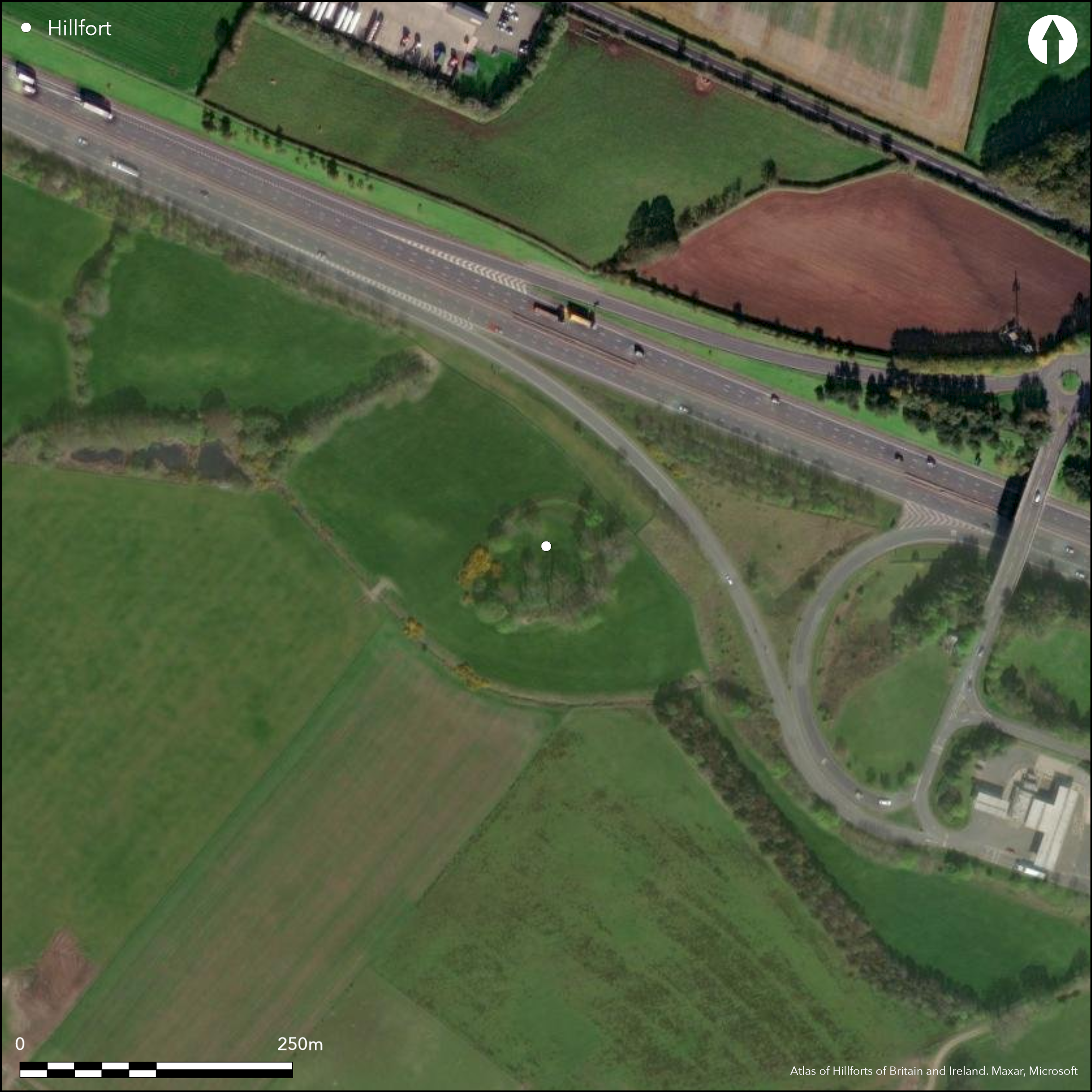
Satellite Imagery
LiDAR 1m DTM Hillshade
Satellite Imagery
Scroll left/right to view further images.
HER: Dumfries & Galloway MDG7759 (None)
NMR: NY 36 NW 18 (67433)
SM: 11994
NGR: NY 3031 6889
X: 330310 Y: 568890 (OSGB36)
This fort or fortified settlement is situated on a low hill immediately WNW of the Gretna motorway service area. Oval on plan, it measures 54m from NE to SW by 42m transversely within twin ramparts with a medial ditch, and the entrance is on the NW. A second gap in the defences on the E is thought to be where a relatively modern track has crossed the fort and the only other feature visible within the interior is probably a relatively recent mound some 6m across. During the 19th century the enclosure was planted with trees and the defences are heavily reduced; the counterscarp rampart is capped by the old plantation bank which was probably accompanied by an external ditch.
Citizen Science: ✗
Reliability of Data: Confirmed
Reliability of Interpretation: Confirmed
X: -344116 Y: 7363747 (EPSG: 3857)
Longitude: -3.091246719220455 Latitude: 55.0096918012528 (EPSG:4326)
Country: Scotland
Current County or Unitary Authority: Dumfries & Galloway
Historic County: Dumfriesshire
Current Parish/Community/Council/Townland: Gretna
None
| Extant | ✓ |
| Cropmark | ✗ |
| Likely Destroyed | ✗ |
None
| Woodland | ✓ |
| Commercial Forestry Plantation | ✗ |
| Parkland | ✗ |
| Pasture (Grazing) | ✓ |
| Arable | ✗ |
| Scrub/Bracken | ✗ |
| Bare Outcrop | ✗ |
| Heather/Moorland | ✗ |
| Heath | ✗ |
| Built-up | ✗ |
| Coastal Grassland | ✗ |
| Other | ✗ |
None
| Contour Fort | ✓ |
| Partial Contour Fort | ✗ |
| Promontory Fort | ✗ |
| Hillslope Fort | ✗ |
| Level Terrain Fort | ✗ |
| Marsh Fort | ✗ |
| Multiple Enclosure Fort | ✗ |
| Hilltop | ✓ |
| Coastal Promontory | ✗ |
| Inland Promontory | ✗ |
| Valley Bottom | ✗ |
| Knoll/Hillock/Outcrop | ✗ |
| Ridge | ✗ |
| Cliff/Plateau-edge/Scarp | ✗ |
| Hillslope | ✗ |
| Lowland | ✗ |
| Spur | ✗ |
Dominant Topographic Feature: None
| North | ✗ |
| Northeast | ✗ |
| East | ✗ |
| Southeast | ✗ |
| South | ✗ |
| Southwest | ✗ |
| West | ✗ |
| Northwest | ✗ |
| Level | ✓ |
Altitude: 30.0m
N/A
In the absence of excavation, there are neither stratified artefacts nor radiocarbon dates to provide a chronology for the defences.
Reliability: D - None
| Pre 1200BC | ✗ |
| 1200BC - 800BC | ✗ |
| 800BC - 400BC | ✗ |
| 400BC - AD50 | ✗ |
| AD50 - AD400 | ✗ |
| AD400 - AD 800 | ✗ |
| Post AD800 | ✗ |
| Unknown | ✓ |
| Pre Hillfort: | None |
| Post Hillfort: | Incorporated into a plantation and cut by a later trackway |
First noted in a parish account probably dating from the 2nd quarter of the 18th century, it is also noted by the local minister in the Statistical Account (13, 1794, 272n), it is shown in 1857 on the 1st edition OS 25-inch map (Dumfriesshire 1862, sheet 63.4). Subsequently visited in 1912 by Alexander Curle during the preparation of the County Inventory for Dumfriesshire (RCAHMS 1920, 92, no.261), it was resurveyed at 1:2500 by the OS in 1970, and revisited in 1973. It was also revisited by RCAHMS in 1980, and Scheduled in 2007.
| 1st Identified Written Reference (1744): | 1721-44 Macfarlane, i, 385 |
| Other (1794): | Noted Statistical Account (13, 1794, 272n) |
| 1st Identified Map Depiction (1857): | Annotated Fort on the 1st edition OS 25-inch map (Dumfriesshire 1862, sheet 63.4) |
| Other (1912): | Description (RCAHMS 1920, 92, no.261) |
| Other (1970): | Resurveyed at 1:2500 by the OS |
| Other (1973): | Visited by the OS |
| Other (1980): | Description by RCAHMS |
| Other (2007): | Scheduled |
| Other (2007): | Scheduled |
Featureless apart from an old trackway and a later mound
None
| None | ✓ |
| Spring | ✗ |
| Stream | ✗ |
| Pool | ✗ |
| Flush | ✗ |
| Well | ✗ |
| Other | ✗ |
None
| No Known Features | ✓ |
| Round Stone Structures | ✗ |
| Rectangular Stone Structures | ✗ |
| Curvilinear Platforms | ✗ |
| Other Roundhouse Evidence | ✗ |
| Pits | ✗ |
| Quarry Hollows | ✗ |
| Other | ✗ |
None
| No Known Excavation | ✓ |
| Pits | ✗ |
| Postholes | ✗ |
| Roundhouses | ✗ |
| Rectangular Structures | ✗ |
| Roads/Tracks | ✗ |
| Quarry Hollows | ✗ |
| Other | ✗ |
| Nothing Found | ✗ |
None
| No Known Geophysics | ✓ |
| Pits | ✗ |
| Roundhouses | ✗ |
| Rectangular Structures | ✗ |
| Roads/Tracks | ✗ |
| Quarry Hollows | ✗ |
| Other | ✗ |
| Nothing Found | ✗ |
None
| No Known Finds | ✓ |
| Pottery | ✗ |
| Metal | ✗ |
| Metalworking | ✗ |
| Human Bones | ✗ |
| Animal Bones | ✗ |
| Lithics | ✗ |
| Environmental | ✗ |
| Other | ✗ |
NO APPARENT FEATURES
| APs Not Checked | ✗ |
| None | ✓ |
| Roundhouses | ✗ |
| Rectangular Structures | ✗ |
| Pits | ✗ |
| Postholes | ✗ |
| Roads/Tracks | ✗ |
| Other | ✗ |
See main summary
| 2: | None |
| 2: | None |
Guard Chambers: ✗
Chevaux de Frise: ✗
| 1. Simple Gap (North west): | None |
Twin ramparts with a medial ditch
| Area 1: | 0.18ha. |
| Total: | 0.18ha. |
Total Footprint Area: 0.44ha.
None
| ✗ | None |
| ✓ | None |
| NE Quadrant: | 2 |
| SE Quadrant: | 2 |
| SW Quadrant: | 2 |
| NW Quadrant: | 2 |
| Total: | 2 |
| Partial Univallate | ✗ |
| Univallate | ✗ |
| Partial Bivallate | ✗ |
| Bivallate | ✓ |
| Partial Multivallate | ✗ |
| Multivallate | ✗ |
| Unknown | ✗ |
| Partial Univallate | ✗ |
| Univallate | ✗ |
| Partial Bivallate | ✗ |
| Bivallate | ✗ |
| Partial Multivallate | ✗ |
| Multivallate | ✗ |
None
| None | ✗ |
| Earthen Bank | ✓ |
| Stone Wall | ✗ |
| Rubble | ✗ |
| Wall-walk | ✗ |
| Evidence of Timber | ✗ |
| Vitrification | ✗ |
| Other Burning | ✗ |
| Palisade | ✗ |
| Counter Scarp Bank | ✗ |
| Berm | ✗ |
| Unfinished | ✗ |
| Other | ✗ |
None
| None | ✗ |
| Earthen Bank | ✗ |
| Stone Wall | ✗ |
| Murus Duplex | ✗ |
| Timber-framed | ✗ |
| Timber-laced | ✗ |
| Vitrification | ✗ |
| Other Burning | ✗ |
| Palisade | ✗ |
| Counter Scarp Bank | ✗ |
| Berm | ✗ |
| Unfinished | ✗ |
| No Known Excavation | ✓ |
| Other | ✗ |
| ✗ | None |
| ✓ | None |
Number of Ditches: 1
| ✗ | None |
Macfarlane, W (1906-8) Geographical collections relating to Scotland. (Mitchell, A and Clark, J T (eds) 3v Edinburgh
RCAHMS (1920) The Royal Commission on the Ancient and Historical Monuments of Scotland. Seventh Report with Inventory of Monuments and Constructions in the County of Dumfries. HMSO: Edinburgh
Statistical Account (1791-9) The statistical account of Scotland, drawn up from the communications of the ministers of the different parishes. Sinclair, J (ed). Edinburgh
Atlas of Hillforts:
Wikidata:
This work is licensed under CC BY-SA 4.0![]()
![]()
![]() and should be cited as:
and should be cited as:
Lock, Gary and Ralston, Ian. 2024. Atlas of Hillforts of Britain and Ireland. Available at: https://hillforts.arch.ox.ac.uk
Document Version 1.1