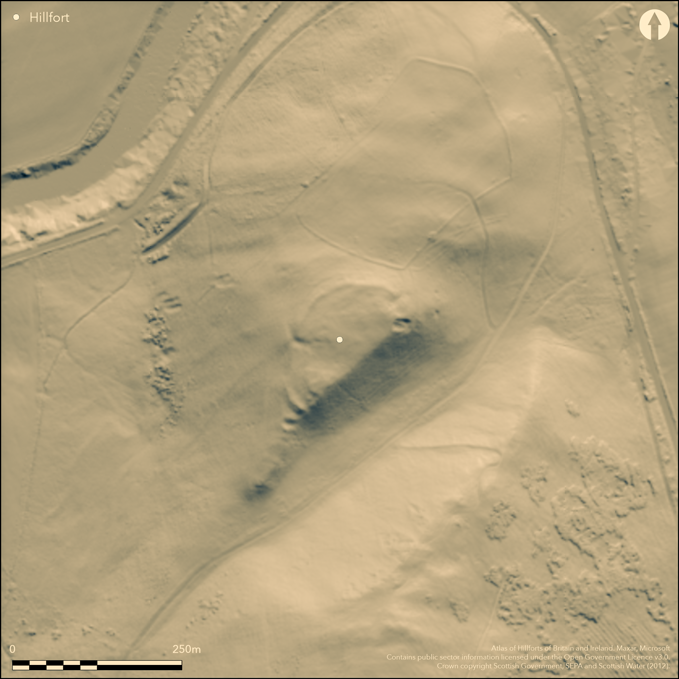
LiDAR 1m DTM Hillshade

Satellite Imagery
LiDAR 1m DTM Hillshade
Satellite Imagery
Scroll left/right to view further images.
HER: Dumfries & Galloway MDG7953 (None)
NMR: NY 38 NW 9 (67650)
SM: 12745
NGR: NY 3383 8816
X: 333830 Y: 588160 (OSGB36)
This fort is D-shaped on plan, backing onto the steep escarpment that forms the SE flank of this low hill projecting N into the valley of the Esk. Little evidence of a rampart can be detected along the crest of this slope, but for much of the rest of the circuit the rampart has been reduced by robbing to a stony scarp from which a small patch of vitrifaction protrudes through the turf on the N. The best preserved sector is at the SW end, where the rampart forms a bank 5m in thickness by 0.7m in height, and is accompanied by two outer banks with a medial ditch, which cut across the narrow spine of the ridge. There are two entrances, one a simple gap in the rampart at the NE end, and the other on the W, where the scarp of the rampart turns deeply inwards to either side; both are approached by hollowed trackways. The interior measures 120m from NE to SW along the chord formed by the edge of the escarpment by a maximum of 60m transversely (0.58ha) and contains evidence of at least sixteen house platforms cut into the slope around the northern and western flanks; the largest measures 7m in diameter.
Citizen Science: ✗
Reliability of Data: Confirmed
Reliability of Interpretation: Confirmed
X: -338490 Y: 7397524 (EPSG: 3857)
Longitude: -3.0407043168082137 Latitude: 55.18330844792661 (EPSG:4326)
Country: Scotland
Current County or Unitary Authority: Dumfries & Galloway
Historic County: Dumfriesshire
Current Parish/Community/Council/Townland: Westerkirk
None
| Extant | ✓ |
| Cropmark | ✗ |
| Likely Destroyed | ✗ |
None
| Woodland | ✗ |
| Commercial Forestry Plantation | ✗ |
| Parkland | ✗ |
| Pasture (Grazing) | ✓ |
| Arable | ✗ |
| Scrub/Bracken | ✗ |
| Bare Outcrop | ✗ |
| Heather/Moorland | ✓ |
| Heath | ✗ |
| Built-up | ✗ |
| Coastal Grassland | ✗ |
| Other | ✗ |
None
| Contour Fort | ✓ |
| Partial Contour Fort | ✗ |
| Promontory Fort | ✗ |
| Hillslope Fort | ✗ |
| Level Terrain Fort | ✗ |
| Marsh Fort | ✗ |
| Multiple Enclosure Fort | ✗ |
| Hilltop | ✓ |
| Coastal Promontory | ✗ |
| Inland Promontory | ✗ |
| Valley Bottom | ✗ |
| Knoll/Hillock/Outcrop | ✗ |
| Ridge | ✗ |
| Cliff/Plateau-edge/Scarp | ✗ |
| Hillslope | ✗ |
| Lowland | ✗ |
| Spur | ✗ |
Dominant Topographic Feature: None
| North | ✗ |
| Northeast | ✗ |
| East | ✗ |
| Southeast | ✗ |
| South | ✗ |
| Southwest | ✗ |
| West | ✗ |
| Northwest | ✗ |
| Level | ✓ |
Altitude: 185.0m
N/A
In the absence of excavation, there are neither stratified artefacts nor radiocarbon dates to provide a chronology for the defences.
Reliability: D - None
| Pre 1200BC | ✗ |
| 1200BC - 800BC | ✗ |
| 800BC - 400BC | ✗ |
| 400BC - AD50 | ✗ |
| AD50 - AD400 | ✗ |
| AD400 - AD 800 | ✗ |
| Post AD800 | ✗ |
| Unknown | ✓ |
| Pre Hillfort: | None |
| Post Hillfort: | Quarrying at the NE end and heavy stone robbing along the rampart |
Assuming that William Crawford's Map of Dumfries-shire (1804) shows the nearby fort on the summit of Craig Hill, rather than the fort below it on Little Hill, this fort apparently escapes detection until the RCAHMS Survey of Marginal Lands about 1955. It was subsequently surveyed by George Jobey in 1969 (Jobey 1971, 84, fig 5). The OS visited in 1979, and the RCAHMS again in 1980, when the vitrifaction was first observed, carrying out a new survey in 1992. It was Scheduled in 1986, and re-Scheduled with a larger area in 2010.
| Other (1955): | Discovered by RCAHMS Survey of Marginal Lands |
| Earthwork Survey (1969): | George Jobey (copies in RCAHMS DFD 278/1-2 P/CO) |
| Other (1979): | Surveyed at 1:10.000 by the OS |
| Other (1980): | Description by RCAHMS |
| Other (1986): | Scheduled |
| Earthwork Survey (1992): | Plan and description (RCAHMS 1997, 131, fig 126; RCAHMS DC32451 & SC1352946; Item DC32628) |
| Other (2010): | Re-Scheduled |
At least sixteen house platforms are visible within the interior.
None
| None | ✓ |
| Spring | ✗ |
| Stream | ✗ |
| Pool | ✗ |
| Flush | ✗ |
| Well | ✗ |
| Other | ✗ |
None
| No Known Features | ✗ |
| Round Stone Structures | ✗ |
| Rectangular Stone Structures | ✗ |
| Curvilinear Platforms | ✓ |
| Other Roundhouse Evidence | ✗ |
| Pits | ✗ |
| Quarry Hollows | ✗ |
| Other | ✗ |
None
| No Known Excavation | ✓ |
| Pits | ✗ |
| Postholes | ✗ |
| Roundhouses | ✗ |
| Rectangular Structures | ✗ |
| Roads/Tracks | ✗ |
| Quarry Hollows | ✗ |
| Other | ✗ |
| Nothing Found | ✗ |
None
| No Known Geophysics | ✓ |
| Pits | ✗ |
| Roundhouses | ✗ |
| Rectangular Structures | ✗ |
| Roads/Tracks | ✗ |
| Quarry Hollows | ✗ |
| Other | ✗ |
| Nothing Found | ✗ |
None
| No Known Finds | ✓ |
| Pottery | ✗ |
| Metal | ✗ |
| Metalworking | ✗ |
| Human Bones | ✗ |
| Animal Bones | ✗ |
| Lithics | ✗ |
| Environmental | ✗ |
| Other | ✗ |
None
| APs Not Checked | ✗ |
| None | ✗ |
| Roundhouses | ✓ |
| Rectangular Structures | ✗ |
| Pits | ✗ |
| Postholes | ✗ |
| Roads/Tracks | ✗ |
| Other | ✗ |
See main summary
| 2: | None |
| 2: | None |
Guard Chambers: ✗
Chevaux de Frise: ✗
| 1. Hollow Way (North east): | None |
| 1. Simple Gap (North east): | None |
| 2. In-turned (West): | Apparently a deep inturn, though possibly simply a rock-cut passage rather than a rampart inturn |
| 2. Hollow Way (West): | None |
Single rampart for most of the circuit, with minor outwork at the SW end
| Area 1: | 0.58ha. |
| Total: | 0.58ha. |
Total Footprint Area: 0.7ha.
None
| ✗ | None |
| ✗ | None |
| NE Quadrant: | 1 |
| SE Quadrant: | 0 |
| SW Quadrant: | 2 |
| NW Quadrant: | 1 |
| Total: | 2 |
| Partial Univallate | ✓ |
| Univallate | ✗ |
| Partial Bivallate | ✓ |
| Bivallate | ✗ |
| Partial Multivallate | ✗ |
| Multivallate | ✗ |
| Unknown | ✗ |
| Partial Univallate | ✗ |
| Univallate | ✗ |
| Partial Bivallate | ✗ |
| Bivallate | ✗ |
| Partial Multivallate | ✗ |
| Multivallate | ✗ |
Counterscarp rampart associated with the short lengths of rampart and ditch across the rocky spine on the SW
| None | ✗ |
| Earthen Bank | ✓ |
| Stone Wall | ✗ |
| Rubble | ✓ |
| Wall-walk | ✗ |
| Evidence of Timber | ✗ |
| Vitrification | ✓ |
| Other Burning | ✗ |
| Palisade | ✗ |
| Counter Scarp Bank | ✓ |
| Berm | ✗ |
| Unfinished | ✗ |
| Other | ✗ |
None
| None | ✗ |
| Earthen Bank | ✗ |
| Stone Wall | ✗ |
| Murus Duplex | ✗ |
| Timber-framed | ✗ |
| Timber-laced | ✗ |
| Vitrification | ✗ |
| Other Burning | ✗ |
| Palisade | ✗ |
| Counter Scarp Bank | ✗ |
| Berm | ✗ |
| Unfinished | ✗ |
| No Known Excavation | ✓ |
| Other | ✗ |
| ✗ | None |
| ✓ | Short ditch across the spine of the ridge on the SW |
Number of Ditches: 1
| ✗ | None |
Jobey, G (1971) 'Early settlements in eastern Dumfriesshire'. Trans Dumfriesshire Galloway Natur Hist Antiq Soc, 3 Ser, 48 (1971), 78-105
RCAHMS (1997) Eastern Dumfriesshire: an archaeological landscape. HMSO: Edinburgh
Atlas of Hillforts:
Wikidata:
This work is licensed under CC BY-SA 4.0![]()
![]()
![]() and should be cited as:
and should be cited as:
Lock, Gary and Ralston, Ian. 2024. Atlas of Hillforts of Britain and Ireland. Available at: https://hillforts.arch.ox.ac.uk
Document Version 1.1