Satellite Imagery
Satellite Imagery
HER: Scottish Borders 67896 (None)
NMR: NY 48 SE 7 (67896)
SM: 1690
NGR: NY 4906 8436
X: 349060 Y: 584360 (OSGB36)
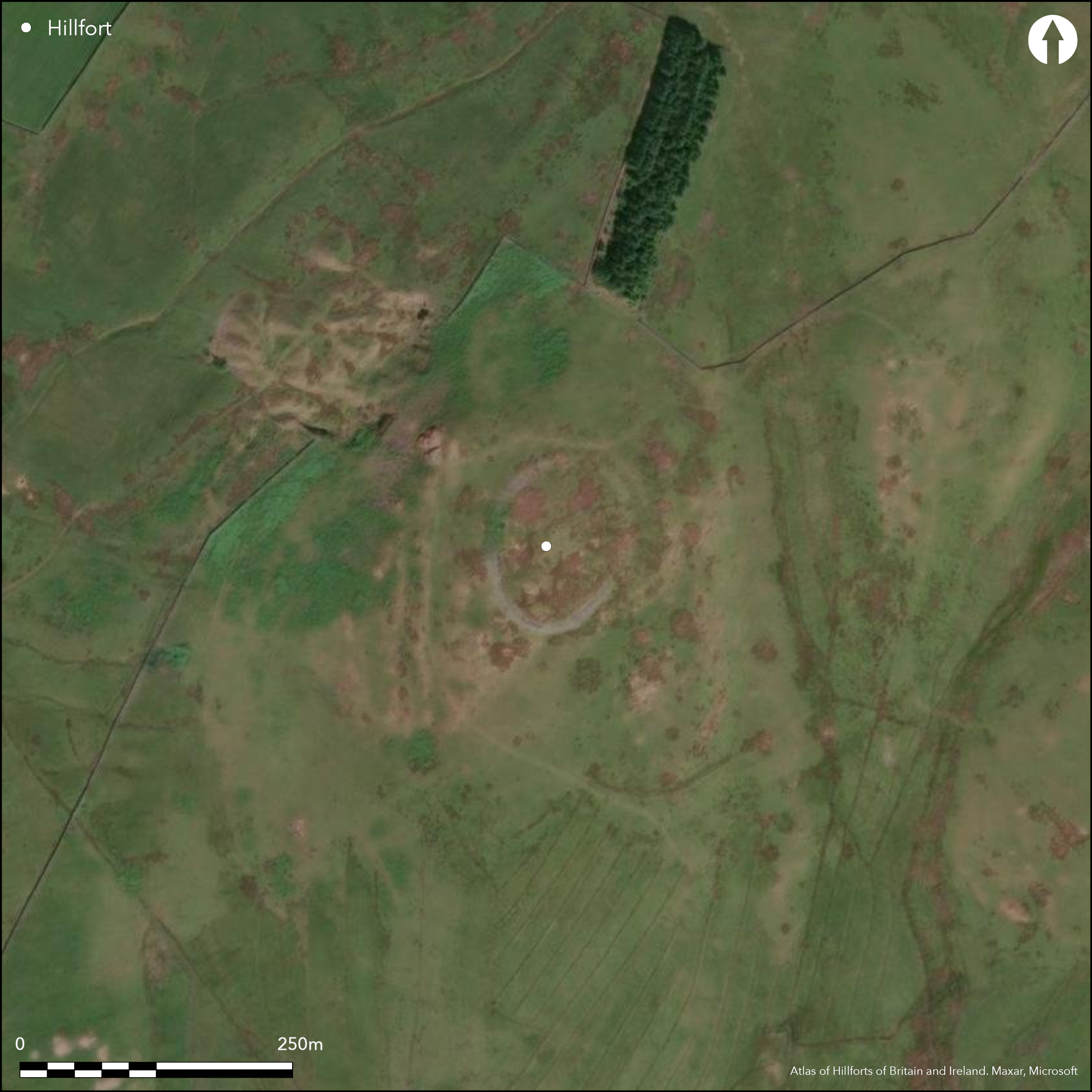
This fort is situated on the summit of Carby Hill and its wall was heavily robbed of stones in the 1820s. Nevertheless, it is oval on plan and measures about 86m from NNE to SSW by 68m transversely (0.48ha) within a band of rubble spread up to 8m in thickness on the S. The wall probably measured in the order of 3m in thickness, though the only evidence of either face is a short run of the outer on the SE; a later field wall extending around its inner margin may mask the line of the inner face. Four gaps in the line of the wall have been noted, one on the SW, another on the NNW and two on the E; that on the SW has the appearance of being original and the status of the others is uncertain. Within the interior the stone footings of at least six round-houses can be seen; they measure in the order of 7m in internal diameter and one appears to have a concentric bank around it.
Citizen Science: ✗
Reliability of Data: Confirmed
Reliability of Interpretation: Confirmed
X: -311791 Y: 7391222 (EPSG: 3857)
Longitude: -2.800869757651093 Latitude: 55.1509709338487 (EPSG:4326)
Country: Scotland
Current County or Unitary Authority: Scottish Borders
Historic County: Roxburghshire
Current Parish/Community/Council/Townland: Castleton
None
| Extant | ✓ |
| Cropmark | ✗ |
| Likely Destroyed | ✗ |
None
| Woodland | ✗ |
| Commercial Forestry Plantation | ✗ |
| Parkland | ✗ |
| Pasture (Grazing) | ✓ |
| Arable | ✗ |
| Scrub/Bracken | ✗ |
| Bare Outcrop | ✗ |
| Heather/Moorland | ✓ |
| Heath | ✗ |
| Built-up | ✗ |
| Coastal Grassland | ✗ |
| Other | ✗ |
None
| Contour Fort | ✓ |
| Partial Contour Fort | ✗ |
| Promontory Fort | ✗ |
| Hillslope Fort | ✗ |
| Level Terrain Fort | ✗ |
| Marsh Fort | ✗ |
| Multiple Enclosure Fort | ✗ |
| Hilltop | ✓ |
| Coastal Promontory | ✗ |
| Inland Promontory | ✗ |
| Valley Bottom | ✗ |
| Knoll/Hillock/Outcrop | ✗ |
| Ridge | ✗ |
| Cliff/Plateau-edge/Scarp | ✗ |
| Hillslope | ✗ |
| Lowland | ✗ |
| Spur | ✗ |
Dominant Topographic Feature: None
| North | ✗ |
| Northeast | ✗ |
| East | ✗ |
| Southeast | ✗ |
| South | ✗ |
| Southwest | ✗ |
| West | ✗ |
| Northwest | ✗ |
| Level | ✓ |
Altitude: 260.0m
N/A
In the absence of excavation, there are neither stratified artefacts nor radiocarbon dates to provide a chronology for the defences.
Reliability: D - None
| Pre 1200BC | ✗ |
| 1200BC - 800BC | ✗ |
| 800BC - 400BC | ✗ |
| 400BC - AD50 | ✗ |
| AD50 - AD400 | ✗ |
| AD400 - AD 800 | ✗ |
| Post AD800 | ✗ |
| Unknown | ✓ |
| Pre Hillfort: | None |
| Post Hillfort: | Heavy stone robbing; also overlain by a drystone field enclosure and by the foundations of four piers for a forest fire watch-tower. |
This fort is first depicted in 1858 on the 1st edition OS 25-inch map (Roxburghshire 1863, sheet 45.15) and shortly after in 1865 described by The Rev John Maughan, who noted that large quantities of stone were robbed from the rampart to build field walls some 40 years before; he also claimed to have observed twelve round-houses within the interior (Maughan 1866, 103-5). It was surveyed by RCAHMS in 1949 (RCAHMS 1956, 90, no.96, fig 129) and in 1963 Richard Feachem, in line with contemporary thought, suggested that the round-houses visible in the interior were likely to belong to a secondary Roman Iron Age occupation (1963, 154); while they may be secondary, this chronology is no longer secure. It was Scheduled 1958. The OS visited the site in 1979.
| 1st Identified Map Depiction (1858): | Annotated Fort on the 1st edition OS 25-inch map (Roxburghshire 1863, sheet 45.15) |
| Other (1865): | Description (Maughan 1866, 103-5) |
| Earthwork Survey (1949): | Plan and description (RCAHMS 1956, 90, no.96, fig 129; RCAHMS RXD 89/2) |
| Other (1958): | Scheduled |
| Other (1979): | Surveyed at 1:10.000 by the OS |
Stone footings of at least six round-houses
None
| None | ✓ |
| Spring | ✗ |
| Stream | ✗ |
| Pool | ✗ |
| Flush | ✗ |
| Well | ✗ |
| Other | ✗ |
None
| No Known Features | ✗ |
| Round Stone Structures | ✓ |
| Rectangular Stone Structures | ✗ |
| Curvilinear Platforms | ✗ |
| Other Roundhouse Evidence | ✗ |
| Pits | ✗ |
| Quarry Hollows | ✗ |
| Other | ✗ |
None
| No Known Excavation | ✓ |
| Pits | ✗ |
| Postholes | ✗ |
| Roundhouses | ✗ |
| Rectangular Structures | ✗ |
| Roads/Tracks | ✗ |
| Quarry Hollows | ✗ |
| Other | ✗ |
| Nothing Found | ✗ |
None
| No Known Geophysics | ✓ |
| Pits | ✗ |
| Roundhouses | ✗ |
| Rectangular Structures | ✗ |
| Roads/Tracks | ✗ |
| Quarry Hollows | ✗ |
| Other | ✗ |
| Nothing Found | ✗ |
None
| No Known Finds | ✓ |
| Pottery | ✗ |
| Metal | ✗ |
| Metalworking | ✗ |
| Human Bones | ✗ |
| Animal Bones | ✗ |
| Lithics | ✗ |
| Environmental | ✗ |
| Other | ✗ |
None
| APs Not Checked | ✗ |
| None | ✗ |
| Roundhouses | ✓ |
| Rectangular Structures | ✗ |
| Pits | ✗ |
| Postholes | ✗ |
| Roads/Tracks | ✗ |
| Other | ✗ |
See main summary
| 4: | None |
| 2: | None |
Guard Chambers: ✗
Chevaux de Frise: ✗
| 1. Simple Gap (East): | None |
| 2. Simple Gap (East): | None |
| 3. Simple Gap (South west): | None |
| 4. Simple Gap (North west): | None |
Single stone rampart
| Area 1: | 0.48ha. |
| Total: | 0.48ha. |
Total Footprint Area: 0.55ha.
None
| ✗ | None |
| ✓ | None |
| NE Quadrant: | 1 |
| SE Quadrant: | 1 |
| SW Quadrant: | 1 |
| NW Quadrant: | 1 |
| Total: | 1 |
| Partial Univallate | ✗ |
| Univallate | ✓ |
| Partial Bivallate | ✗ |
| Bivallate | ✗ |
| Partial Multivallate | ✗ |
| Multivallate | ✗ |
| Unknown | ✗ |
| Partial Univallate | ✗ |
| Univallate | ✗ |
| Partial Bivallate | ✗ |
| Bivallate | ✗ |
| Partial Multivallate | ✗ |
| Multivallate | ✗ |
None
| None | ✗ |
| Earthen Bank | ✗ |
| Stone Wall | ✓ |
| Rubble | ✗ |
| Wall-walk | ✗ |
| Evidence of Timber | ✗ |
| Vitrification | ✗ |
| Other Burning | ✗ |
| Palisade | ✗ |
| Counter Scarp Bank | ✗ |
| Berm | ✗ |
| Unfinished | ✗ |
| Other | ✗ |
None
| None | ✗ |
| Earthen Bank | ✗ |
| Stone Wall | ✗ |
| Murus Duplex | ✗ |
| Timber-framed | ✗ |
| Timber-laced | ✗ |
| Vitrification | ✗ |
| Other Burning | ✗ |
| Palisade | ✗ |
| Counter Scarp Bank | ✗ |
| Berm | ✗ |
| Unfinished | ✗ |
| No Known Excavation | ✓ |
| Other | ✗ |
| ✗ | None |
| ✗ | None |
Number of Ditches: None
| ✗ | None |
Feachem, R (1963) A guide to prehistoric Scotland. Batsford: London (p 154)
Maughan, J (1866) 'Notice of the fort on Cairby Hill, and other antiquities in Liddlesdale,in a letter to Mr Stuart, Sec. S.A. Scot'. Proc Soc Antiq Scot 6 (1864-66), 103-7
RCAHMS (1956) The Royal Commission on the Ancient and Historical Monuments of Scotland. An inventory of the ancient and historical monuments of Roxburghshire: with the fourteenth report of the Commission, 2v. HMSO: Edinburgh
Atlas of Hillforts:
Wikidata:
This work is licensed under CC BY-SA 4.0![]()
![]()
![]() and should be cited as:
and should be cited as:
Lock, Gary and Ralston, Ian. 2024. Atlas of Hillforts of Britain and Ireland. Available at: https://hillforts.arch.ox.ac.uk
Document Version 1.1