Satellite Imagery
Satellite Imagery
HER: The West of Scotland Archaeology Service 4780 (None)
NMR: NS 03 SW 4 (40197)
SM: 4710
NGR: NS 0464 3384
X: 204640 Y: 633840 (OSGB36)
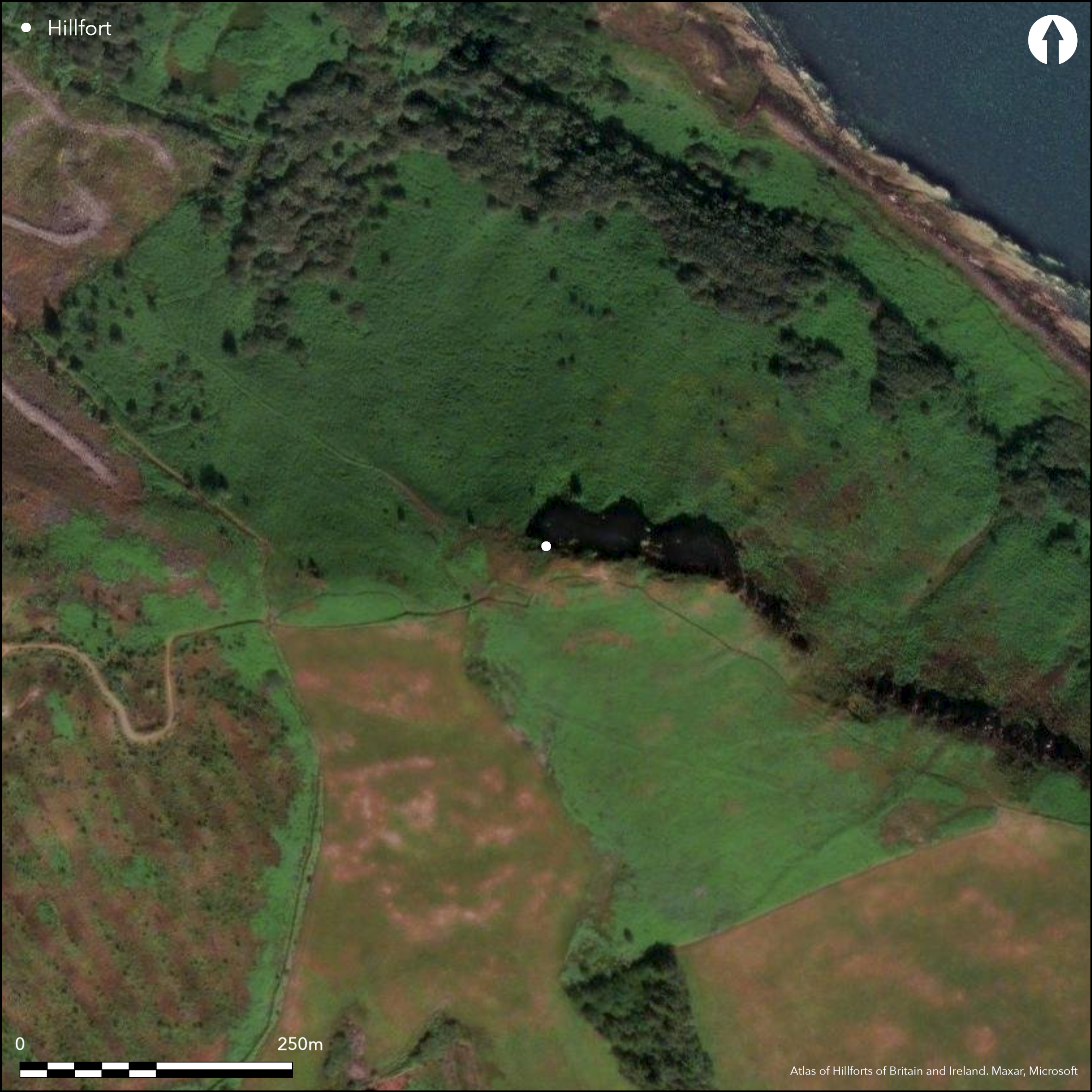
This small fort occupies the summit of a hillock on the eastern spur of the Clauchlands Hills, where the ground falls away precipitously on the NE to the rocky shore 160m below. Oval on plan, it measures 30m from E to W by no more than 10m transversely (0.02ha) within a grass-grown rampart only 0.6m in height and spread some 3m in maximum thickness. The position of the entrance is unknown, but the OS suggest it is probably on the E, opening onto a terrace measuring about 14m by 10m, which has been levelled into the slope below the rampart. This side, which is also the easiest line of approach, has been provided with an outwork lying beyond the terrace and comprising a ditch some 6m in breadth by 0.8m in depth. The interior of the fort is featureless.
Citizen Science: ✗
Reliability of Data: Confirmed
Reliability of Interpretation: Confirmed
X: -567649 Y: 7471127 (EPSG: 3857)
Longitude: -5.099278898554737 Latitude: 55.55902787188289 (EPSG:4326)
Country: Scotland
Current County or Unitary Authority: North Ayrshire
Historic County: Buteshire
Current Parish/Community/Council/Townland: Kilbride
None
| Extant | ✓ |
| Cropmark | ✗ |
| Likely Destroyed | ✗ |
None
| Woodland | ✗ |
| Commercial Forestry Plantation | ✗ |
| Parkland | ✗ |
| Pasture (Grazing) | ✗ |
| Arable | ✗ |
| Scrub/Bracken | ✓ |
| Bare Outcrop | ✗ |
| Heather/Moorland | ✓ |
| Heath | ✗ |
| Built-up | ✗ |
| Coastal Grassland | ✗ |
| Other | ✗ |
None
| Contour Fort | ✓ |
| Partial Contour Fort | ✗ |
| Promontory Fort | ✗ |
| Hillslope Fort | ✗ |
| Level Terrain Fort | ✗ |
| Marsh Fort | ✗ |
| Multiple Enclosure Fort | ✗ |
| Hilltop | ✓ |
| Coastal Promontory | ✗ |
| Inland Promontory | ✗ |
| Valley Bottom | ✗ |
| Knoll/Hillock/Outcrop | ✗ |
| Ridge | ✗ |
| Cliff/Plateau-edge/Scarp | ✗ |
| Hillslope | ✗ |
| Lowland | ✗ |
| Spur | ✗ |
Dominant Topographic Feature: None
| North | ✗ |
| Northeast | ✗ |
| East | ✗ |
| Southeast | ✗ |
| South | ✗ |
| Southwest | ✗ |
| West | ✗ |
| Northwest | ✗ |
| Level | ✓ |
Altitude: 163.0m
N/A
In the absence of excavation, there are neither stratified artefacts nor radiocarbon dates to provide a chronology for the defences.
Reliability: D - None
| Pre 1200BC | ✗ |
| 1200BC - 800BC | ✗ |
| 800BC - 400BC | ✗ |
| 400BC - AD50 | ✗ |
| AD50 - AD400 | ✗ |
| AD400 - AD 800 | ✗ |
| Post AD800 | ✗ |
| Unknown | ✓ |
| Pre Hillfort: | None |
| Post Hillfort: | None |
First depicted on the map of Buteshire in John Thomson's Atlas of Scotland (1832), it is shown in greater detail on the 1st edition OS 25-inch map (Argyll and Bute 1869, sheet 250.1). Noted in 1807 by J Headrick, who suggested that it was a vitirfied fort (1807, 64), and later by J McArthur (1873, 77), it was also described by James Balfour, who dismissed the earlier suggestions that the wall was vitrified (1910, 181). It was visited by the OS in 1977 and Scheduled in 1989.
| 1st Identified Written Reference (1807): | Noted (Headrick 1807, 64) |
| 1st Identified Map Depiction (1832): | John Thomson's Atlas of Scotland (1832) |
| Other (1864): | Annotated Fort on the 1st edition OS 25-inch map (Argyll and Bute 1869, sheet 250.1) |
| Other (1873): | Noted (McArthur 1873, 77) |
| Other (1910): | Described by James Balfour (1910, 181) |
| Other (1977): | Surveyed at 1:10.000 by the OS |
| Other (1989): | Scheduled |
Featureless
None
| None | ✓ |
| Spring | ✗ |
| Stream | ✗ |
| Pool | ✗ |
| Flush | ✗ |
| Well | ✗ |
| Other | ✗ |
None
| No Known Features | ✓ |
| Round Stone Structures | ✗ |
| Rectangular Stone Structures | ✗ |
| Curvilinear Platforms | ✗ |
| Other Roundhouse Evidence | ✗ |
| Pits | ✗ |
| Quarry Hollows | ✗ |
| Other | ✗ |
None
| No Known Excavation | ✓ |
| Pits | ✗ |
| Postholes | ✗ |
| Roundhouses | ✗ |
| Rectangular Structures | ✗ |
| Roads/Tracks | ✗ |
| Quarry Hollows | ✗ |
| Other | ✗ |
| Nothing Found | ✗ |
None
| No Known Geophysics | ✓ |
| Pits | ✗ |
| Roundhouses | ✗ |
| Rectangular Structures | ✗ |
| Roads/Tracks | ✗ |
| Quarry Hollows | ✗ |
| Other | ✗ |
| Nothing Found | ✗ |
None
| No Known Finds | ✓ |
| Pottery | ✗ |
| Metal | ✗ |
| Metalworking | ✗ |
| Human Bones | ✗ |
| Animal Bones | ✗ |
| Lithics | ✗ |
| Environmental | ✗ |
| Other | ✗ |
NO APPARENT FEATURES
| APs Not Checked | ✓ |
| None | ✗ |
| Roundhouses | ✗ |
| Rectangular Structures | ✗ |
| Pits | ✗ |
| Postholes | ✗ |
| Roads/Tracks | ✗ |
| Other | ✗ |
See main summary
| 0: | None |
| 2: | OS suggest it is on the E |
Guard Chambers: ✗
Chevaux de Frise: ✗
single ruinous wall with an outwork on the ESE
| Area 1: | 0.02ha. |
| Total: | 0.02ha. |
Total Footprint Area: Noneha.
None
| ✗ | None |
| ✓ | None |
| NE Quadrant: | 1 |
| SE Quadrant: | 2 |
| SW Quadrant: | 1 |
| NW Quadrant: | 1 |
| Total: | 2 |
| Partial Univallate | ✓ |
| Univallate | ✗ |
| Partial Bivallate | ✓ |
| Bivallate | ✗ |
| Partial Multivallate | ✗ |
| Multivallate | ✗ |
| Unknown | ✗ |
| Partial Univallate | ✗ |
| Univallate | ✗ |
| Partial Bivallate | ✗ |
| Bivallate | ✗ |
| Partial Multivallate | ✗ |
| Multivallate | ✗ |
Described by the OS as an earth and stone bank, but almost certainly the remains of a faced wall. Antiquarian claims that the wall was vitrified were dismissed by Balfour
| None | ✗ |
| Earthen Bank | ✓ |
| Stone Wall | ✓ |
| Rubble | ✗ |
| Wall-walk | ✗ |
| Evidence of Timber | ✗ |
| Vitrification | ✗ |
| Other Burning | ✗ |
| Palisade | ✗ |
| Counter Scarp Bank | ✗ |
| Berm | ✗ |
| Unfinished | ✗ |
| Other | ✗ |
None
| None | ✗ |
| Earthen Bank | ✗ |
| Stone Wall | ✗ |
| Murus Duplex | ✗ |
| Timber-framed | ✗ |
| Timber-laced | ✗ |
| Vitrification | ✗ |
| Other Burning | ✗ |
| Palisade | ✗ |
| Counter Scarp Bank | ✗ |
| Berm | ✗ |
| Unfinished | ✗ |
| No Known Excavation | ✓ |
| Other | ✗ |
| ✗ | None |
| ✓ | Outwork on the ESE |
Number of Ditches: 1
| ✗ | None |
Balfour, J A (ed.) (1910) The book of Arran, vol.1. Glasgow
Headrick, J (1807) View of the mineralogy, agriculture, manufactures and fisheries of the island of Arran, with notices of antiquities and suggestions for improving the agriculture and fisheries of the highlands and islands of Scotland, Edinburgh
McArthur, J (1873) The antiquities of Arran with a historical sketch of the island embracing an account of the Sudreyjar under the Norsemen, Edinburgh
McLellan, R (1970) Isle of Arran (p 79)
Atlas of Hillforts:
Wikidata:
This work is licensed under CC BY-SA 4.0![]()
![]()
![]() and should be cited as:
and should be cited as:
Lock, Gary and Ralston, Ian. 2024. Atlas of Hillforts of Britain and Ireland. Available at: https://hillforts.arch.ox.ac.uk
Document Version 1.1