Satellite Imagery
Satellite Imagery
HER: The West of Scotland Archaeology Service 4802 (None)
NMR: NS 04 NW 7 (40220)
SM: 412
NGR: NS 0018 4738
X: 200180 Y: 647380 (OSGB36)
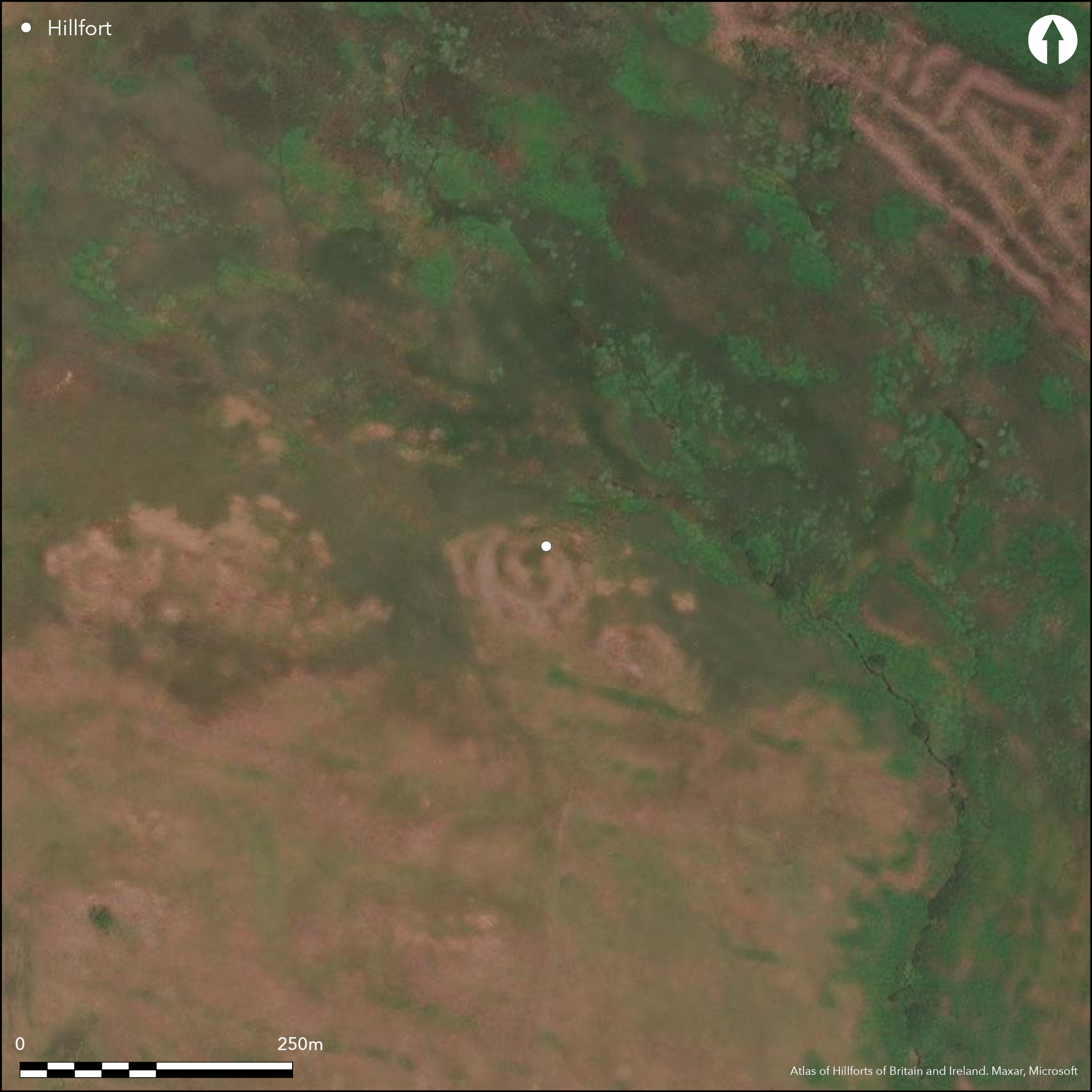
This fort occupies a rocky hillock that rises up on the S side of a burn gully on the SE flank of Torr Reamhar, one of the hills forming the N side of North Glen Sannox. Oval on plan, it measures about 35m from NW to SE by 30m transversely (0.08ha) within a tumbled stone wall 0.4m in height and spread 5m in maximum thickness. A few outer facing-stones are visible on the S, and lining the entrance on the SE, which is 3m wide. The rocky interior is featureless, but what is probably a relatively modern shelter built within the ruins of the wall on the W was mistaken by James Balfour as an ancient structure. In addition to the inner wall enclosing the summit, there are outer walls forming annexes on the NW and SE respectively. The latter provides additional protection to the entrance, comprising a crescent of wall some 2.5m thick by up to 0.8m high set about 9m in front of the inner rampart and also pierced by an entrance. The annexe on the NW forms a rather larger enclosure, measuring about 30m from NE to SW by 20m transversely (0.04ha) within a ruined wall spread 3m in htickness and 0.3m in height; no evidence of an entrance has been noted in this annexe.
Citizen Science: ✗
Reliability of Data: Confirmed
Reliability of Interpretation: Confirmed
X: -576602 Y: 7494717 (EPSG: 3857)
Longitude: -5.1797050776200875 Latitude: 55.67869644700946 (EPSG:4326)
Country: Scotland
Current County or Unitary Authority: North Ayrshire
Historic County: Buteshire
Current Parish/Community/Council/Townland: Kilbride
None
| Extant | ✓ |
| Cropmark | ✗ |
| Likely Destroyed | ✗ |
None
| Woodland | ✗ |
| Commercial Forestry Plantation | ✗ |
| Parkland | ✗ |
| Pasture (Grazing) | ✓ |
| Arable | ✗ |
| Scrub/Bracken | ✗ |
| Bare Outcrop | ✗ |
| Heather/Moorland | ✓ |
| Heath | ✗ |
| Built-up | ✗ |
| Coastal Grassland | ✗ |
| Other | ✗ |
None
| Contour Fort | ✓ |
| Partial Contour Fort | ✗ |
| Promontory Fort | ✗ |
| Hillslope Fort | ✗ |
| Level Terrain Fort | ✗ |
| Marsh Fort | ✗ |
| Multiple Enclosure Fort | ✗ |
| Hilltop | ✗ |
| Coastal Promontory | ✗ |
| Inland Promontory | ✗ |
| Valley Bottom | ✗ |
| Knoll/Hillock/Outcrop | ✓ |
| Ridge | ✗ |
| Cliff/Plateau-edge/Scarp | ✗ |
| Hillslope | ✗ |
| Lowland | ✗ |
| Spur | ✓ |
Dominant Topographic Feature: None
| North | ✗ |
| Northeast | ✗ |
| East | ✗ |
| Southeast | ✗ |
| South | ✗ |
| Southwest | ✗ |
| West | ✗ |
| Northwest | ✗ |
| Level | ✓ |
Altitude: 195.0m
N/A
In the absence of excavation, there are neither stratified artefacts nor radiocarbon dates to provide a chronology for the defences.
Reliability: D - None
| Pre 1200BC | ✗ |
| 1200BC - 800BC | ✗ |
| 800BC - 400BC | ✗ |
| 400BC - AD50 | ✗ |
| AD50 - AD400 | ✗ |
| AD400 - AD 800 | ✗ |
| Post AD800 | ✗ |
| Unknown | ✓ |
| Pre Hillfort: | None |
| Post Hillfort: | None |
First depicted in 1864 on the 1st edition OS 6-inch map (Argyll and Bute 1869, sheet 238), it was described by James Balfour about 1910 (1910, 175). It was visited by the OS in 1977 and Scheduled in 1953.
| 1st Identified Map Depiction (1864): | Annotated Fort on the 1st edition OS 6-inch map (Argyll and Bute 1869, sheet 238) |
| Other (1910): | Description by James Balfour (Balfour 1910, 175) |
| Other (1953): | Scheduled |
| Other (1977): | Surveyed at 1:10.000 by the OS |
Featureless and largely outcrop
None
| None | ✓ |
| Spring | ✗ |
| Stream | ✗ |
| Pool | ✗ |
| Flush | ✗ |
| Well | ✗ |
| Other | ✗ |
None
| No Known Features | ✓ |
| Round Stone Structures | ✗ |
| Rectangular Stone Structures | ✗ |
| Curvilinear Platforms | ✗ |
| Other Roundhouse Evidence | ✗ |
| Pits | ✗ |
| Quarry Hollows | ✗ |
| Other | ✗ |
None
| No Known Excavation | ✓ |
| Pits | ✗ |
| Postholes | ✗ |
| Roundhouses | ✗ |
| Rectangular Structures | ✗ |
| Roads/Tracks | ✗ |
| Quarry Hollows | ✗ |
| Other | ✗ |
| Nothing Found | ✗ |
None
| No Known Geophysics | ✓ |
| Pits | ✗ |
| Roundhouses | ✗ |
| Rectangular Structures | ✗ |
| Roads/Tracks | ✗ |
| Quarry Hollows | ✗ |
| Other | ✗ |
| Nothing Found | ✗ |
None
| No Known Finds | ✓ |
| Pottery | ✗ |
| Metal | ✗ |
| Metalworking | ✗ |
| Human Bones | ✗ |
| Animal Bones | ✗ |
| Lithics | ✗ |
| Environmental | ✗ |
| Other | ✗ |
NO APPARENT FEATURES
| APs Not Checked | ✗ |
| None | ✓ |
| Roundhouses | ✗ |
| Rectangular Structures | ✗ |
| Pits | ✗ |
| Postholes | ✗ |
| Roads/Tracks | ✗ |
| Other | ✗ |
See main summary
| 1: | None |
| 2: | None |
Guard Chambers: ✗
Chevaux de Frise: ✗
| 1. Simple Gap (South east): | Some facing remains in place |
Single wall with outworks enclosing annexes
| Area 1: | 0.08ha. |
| Total: | 0.08ha. |
Total Footprint Area: 0.25ha.
None
| ✗ | None |
| ✓ | While the annexe on the SE forms an outwork to the inner wall, that on the NW may represent an independent enclosure |
| NE Quadrant: | 1 |
| SE Quadrant: | 2 |
| SW Quadrant: | 1 |
| NW Quadrant: | 1 |
| Total: | 2 |
| Partial Univallate | ✓ |
| Univallate | ✗ |
| Partial Bivallate | ✓ |
| Bivallate | ✗ |
| Partial Multivallate | ✗ |
| Multivallate | ✗ |
| Unknown | ✗ |
| Partial Univallate | ✗ |
| Univallate | ✗ |
| Partial Bivallate | ✗ |
| Bivallate | ✗ |
| Partial Multivallate | ✗ |
| Multivallate | ✗ |
None
| None | ✗ |
| Earthen Bank | ✗ |
| Stone Wall | ✓ |
| Rubble | ✗ |
| Wall-walk | ✗ |
| Evidence of Timber | ✗ |
| Vitrification | ✗ |
| Other Burning | ✗ |
| Palisade | ✗ |
| Counter Scarp Bank | ✗ |
| Berm | ✗ |
| Unfinished | ✗ |
| Other | ✗ |
None
| None | ✗ |
| Earthen Bank | ✗ |
| Stone Wall | ✗ |
| Murus Duplex | ✗ |
| Timber-framed | ✗ |
| Timber-laced | ✗ |
| Vitrification | ✗ |
| Other Burning | ✗ |
| Palisade | ✗ |
| Counter Scarp Bank | ✗ |
| Berm | ✗ |
| Unfinished | ✗ |
| No Known Excavation | ✓ |
| Other | ✗ |
| ✗ | None |
| ✗ | None |
Number of Ditches: None
| ✓ | Outworks enclose annexes on the NW and SE, the latter providing additional protection to the entrance and the former an enclosure of about 0.04ha. the relationship between this larger annexe and the inner fort is unknown and it conceivably represents an independent enclosure. |
Balfour, J A (ed.) (1910) The book of Arran, vol.1. Glasgow
Atlas of Hillforts:
Wikidata:
This work is licensed under CC BY-SA 4.0![]()
![]()
![]() and should be cited as:
and should be cited as:
Lock, Gary and Ralston, Ian. 2024. Atlas of Hillforts of Britain and Ireland. Available at: https://hillforts.arch.ox.ac.uk
Document Version 1.1