LiDAR 1m DTM Hillshade
Satellite Imagery
LiDAR 1m DTM Hillshade
Satellite Imagery
Scroll left/right to view further images.
HER: The West of Scotland Archaeology Service 5211 (None)
NMR: NS 15 NE 7 (40633)
SM: None
NGR: NS 1819 5796
X: 218244 Y: 657987 (OSGB36)
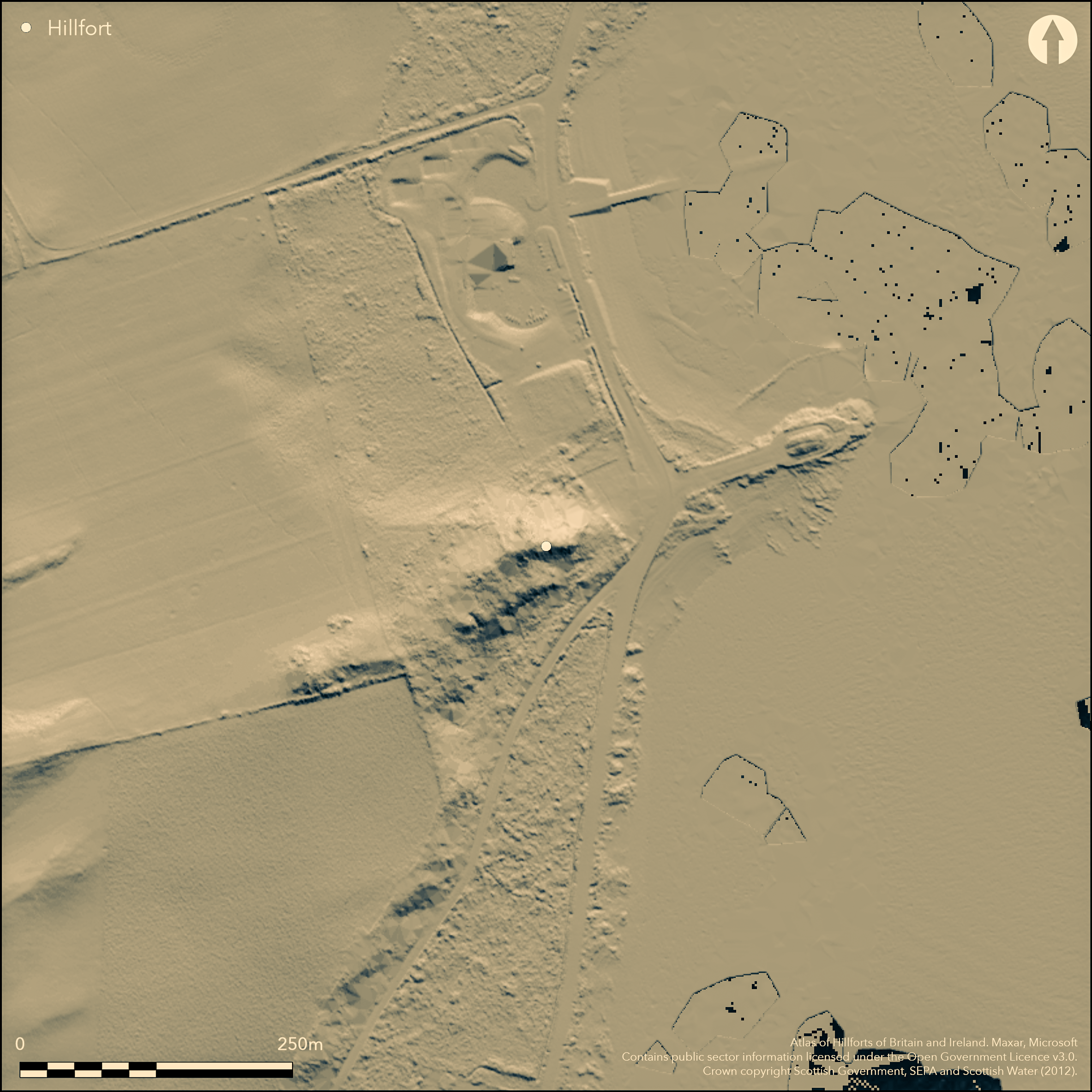
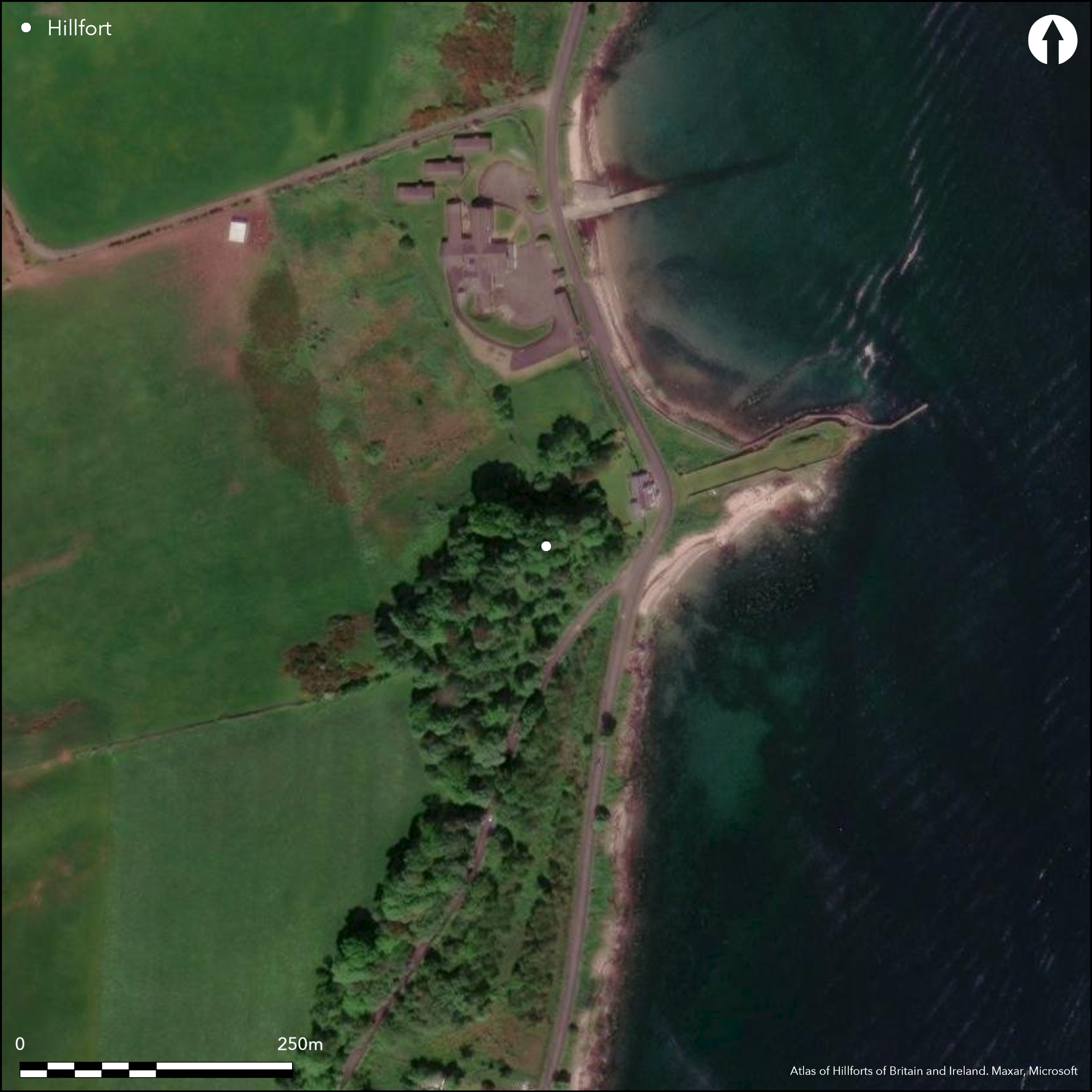
This fort occupies a promontory formed by the old shoreline overlooking the jetty at Downcraig Ferry. The general axis of the promontory lies NE and SW, terminating on the NE on Down Craig itself, a hillock that projects out towards the pier as a narrow spine. The defences lie on the lower ground to the SW of the hillock, comprising a single rampart with an external ditch and traces of a counterscarp bank, which have been drawn across the neck of the promontory in a shallow arc. Despite William Keddie's description of pieces of vitrifaction in 1861 (Keddie 1867, 238-9), in 2014 no trace of vitrifaction could be seen in the remains of a trench that has been dug across the defences relatively recently. The interior measures about 40m from NE to SW by a maximum of 32m transversely (0.06ha) immediately to the rear of the inner rampart. The interior is featureless and there is nothing to indicate the position of the entrance.
Citizen Science: ✓
Reliability of Data: Confirmed
Reliability of Interpretation: Confirmed
X: -545452 Y: 7514938 (EPSG: 3857)
Longitude: -4.899880608625258 Latitude: 55.780981954021726 (EPSG:4326)
Country: Scotland
Current County or Unitary Authority: North Ayrshire
Historic County: Buteshire
Current Parish/Community/Council/Townland: Cumbrae
None
| Extant | ✓ |
| Cropmark | ✗ |
| Likely Destroyed | ✗ |
None
| Woodland | ✓ |
| Commercial Forestry Plantation | ✗ |
| Parkland | ✗ |
| Pasture (Grazing) | ✗ |
| Arable | ✗ |
| Scrub/Bracken | ✓ |
| Bare Outcrop | ✗ |
| Heather/Moorland | ✗ |
| Heath | ✗ |
| Built-up | ✗ |
| Coastal Grassland | ✗ |
| Other | ✗ |
Although not tide-washed, this is in effect and origin a coastal promontory
| Contour Fort | ✗ |
| Partial Contour Fort | ✗ |
| Promontory Fort | ✓ |
| Hillslope Fort | ✗ |
| Level Terrain Fort | ✗ |
| Marsh Fort | ✗ |
| Multiple Enclosure Fort | ✗ |
| Hilltop | ✗ |
| Coastal Promontory | ✓ |
| Inland Promontory | ✗ |
| Valley Bottom | ✗ |
| Knoll/Hillock/Outcrop | ✗ |
| Ridge | ✗ |
| Cliff/Plateau-edge/Scarp | ✗ |
| Hillslope | ✗ |
| Lowland | ✗ |
| Spur | ✗ |
Dominant Topographic Feature: None
| North | ✗ |
| Northeast | ✗ |
| East | ✗ |
| Southeast | ✗ |
| South | ✗ |
| Southwest | ✗ |
| West | ✗ |
| Northwest | ✗ |
| Level | ✓ |
Altitude: 15.0m
N/A
In the absence of excavation, there are neither stratified artefacts nor radiocarbon dates to provide a chronology for the defences.
Reliability: D - None
| Pre 1200BC | ✗ |
| 1200BC - 800BC | ✗ |
| 800BC - 400BC | ✗ |
| 400BC - AD50 | ✗ |
| AD50 - AD400 | ✗ |
| AD400 - AD 800 | ✗ |
| Post AD800 | ✗ |
| Unknown | ✓ |
| Pre Hillfort: | None |
| Post Hillfort: | None |
Surveyed as a topographical feature in 1856 for the 1st edition OS 25-inch map (Argyll and Bute 1869, sheet 246.6), it is first referred to about 1867 by William Keddie as a vitrified fort (1867, 238-9), appearing in many lists of vitrified forts thereafter (Christison 1898, 196, no.44; Childe 1946, 136, no.52; Cotton 1954, 72). Even in Keddie's day, it seems the defences were largely hidden by trees and undergrowth, and it is first depicted in 1964 as a rampart and ditch 1:2500 by the OS, who could find no trace of vitrifaction. Most recently John Lumley has provided a detailed record of the remains for the Atlas Project; visible exposures of the banks appeared earthen.
| 1st Identified Written Reference (1861): | Identified as vitrified fort by William Keddie (1868, 238-9) |
| 1st Identified Map Depiction (1964): | Surveyed at 1:2500 by the OS |
| Earthwork Survey (2014): | John Lumley |
Featureless under woodland and dense undergrowth
None
| None | ✓ |
| Spring | ✗ |
| Stream | ✗ |
| Pool | ✗ |
| Flush | ✗ |
| Well | ✗ |
| Other | ✗ |
None
| No Known Features | ✓ |
| Round Stone Structures | ✗ |
| Rectangular Stone Structures | ✗ |
| Curvilinear Platforms | ✗ |
| Other Roundhouse Evidence | ✗ |
| Pits | ✗ |
| Quarry Hollows | ✗ |
| Other | ✗ |
None
| No Known Excavation | ✓ |
| Pits | ✗ |
| Postholes | ✗ |
| Roundhouses | ✗ |
| Rectangular Structures | ✗ |
| Roads/Tracks | ✗ |
| Quarry Hollows | ✗ |
| Other | ✗ |
| Nothing Found | ✗ |
None
| No Known Geophysics | ✓ |
| Pits | ✗ |
| Roundhouses | ✗ |
| Rectangular Structures | ✗ |
| Roads/Tracks | ✗ |
| Quarry Hollows | ✗ |
| Other | ✗ |
| Nothing Found | ✗ |
None
| No Known Finds | ✓ |
| Pottery | ✗ |
| Metal | ✗ |
| Metalworking | ✗ |
| Human Bones | ✗ |
| Animal Bones | ✗ |
| Lithics | ✗ |
| Environmental | ✗ |
| Other | ✗ |
NO APPARENT FEATURES; under woodland
| APs Not Checked | ✗ |
| None | ✓ |
| Roundhouses | ✗ |
| Rectangular Structures | ✗ |
| Pits | ✗ |
| Postholes | ✗ |
| Roads/Tracks | ✗ |
| Other | ✗ |
None known
| 0: | None |
| 2: | Not known |
Guard Chambers: ✗
Chevaux de Frise: ✗
Rampart and ditch with possible counterscarp bank drawn across a promontory
| Area 1: | 0.06ha. |
| Total: | 0.06ha. |
Total Footprint Area: Noneha.
None
| ✗ | None |
| ✗ | None |
| NE Quadrant: | 0 |
| SE Quadrant: | 0 |
| SW Quadrant: | 1 |
| NW Quadrant: | 0 |
| Total: | 1 |
| Partial Univallate | ✓ |
| Univallate | ✗ |
| Partial Bivallate | ✗ |
| Bivallate | ✗ |
| Partial Multivallate | ✗ |
| Multivallate | ✗ |
| Unknown | ✗ |
| Partial Univallate | ✗ |
| Univallate | ✗ |
| Partial Bivallate | ✗ |
| Bivallate | ✗ |
| Partial Multivallate | ✗ |
| Multivallate | ✗ |
Vitrifaction was observed by William Keddie in 1861, and while none has been found since, he was familiar with vitrifaction from other sites and describes it in convincing detail
| None | ✗ |
| Earthen Bank | ✓ |
| Stone Wall | ✗ |
| Rubble | ✗ |
| Wall-walk | ✗ |
| Evidence of Timber | ✗ |
| Vitrification | ✓ |
| Other Burning | ✗ |
| Palisade | ✗ |
| Counter Scarp Bank | ✓ |
| Berm | ✗ |
| Unfinished | ✗ |
| Other | ✗ |
None
| None | ✗ |
| Earthen Bank | ✗ |
| Stone Wall | ✗ |
| Murus Duplex | ✗ |
| Timber-framed | ✗ |
| Timber-laced | ✗ |
| Vitrification | ✗ |
| Other Burning | ✗ |
| Palisade | ✗ |
| Counter Scarp Bank | ✗ |
| Berm | ✗ |
| Unfinished | ✗ |
| No Known Excavation | ✓ |
| Other | ✗ |
| ✗ | None |
| ✓ | None |
Number of Ditches: 1
| ✗ | None |
Childe, V G (1946) Scotland before the Scots: being the Rhind lectures 1944, London
Christison, D (1898) Early fortifications in Scotland: motes, camps and forts: the Rhind lectures in archaeology for 1894, Edinburgh
Cotton, M A (1954) 'British camps with timber-laced ramparts', Archaeol J, vol.111
Keddie, W (1868) 'On the remains of a vitrified fort, or site, in the island of Cumbrae, with notes on the vitrifies forts of Berigonium, Glen Nevis, Craig Phadrick, Portencross, and Bute., Trans Glasgow Archaeol Soc 1 (1867)
Atlas of Hillforts:
Wikidata:
This work is licensed under CC BY-SA 4.0![]()
![]()
![]() and should be cited as:
and should be cited as:
Lock, Gary and Ralston, Ian. 2024. Atlas of Hillforts of Britain and Ireland. Available at: https://hillforts.arch.ox.ac.uk
Document Version 1.1