LiDAR 1m DTM Hillshade
Satellite Imagery
LiDAR 1m DTM Hillshade
Satellite Imagery
Scroll left/right to view further images.
HER: The West of Scotland Archaeology Service 5407 (None)
NMR: NS 20 NE 6 (40829)
SM: 2176
NGR: NS 2986 0738
X: 229860 Y: 607380 (OSGB36)
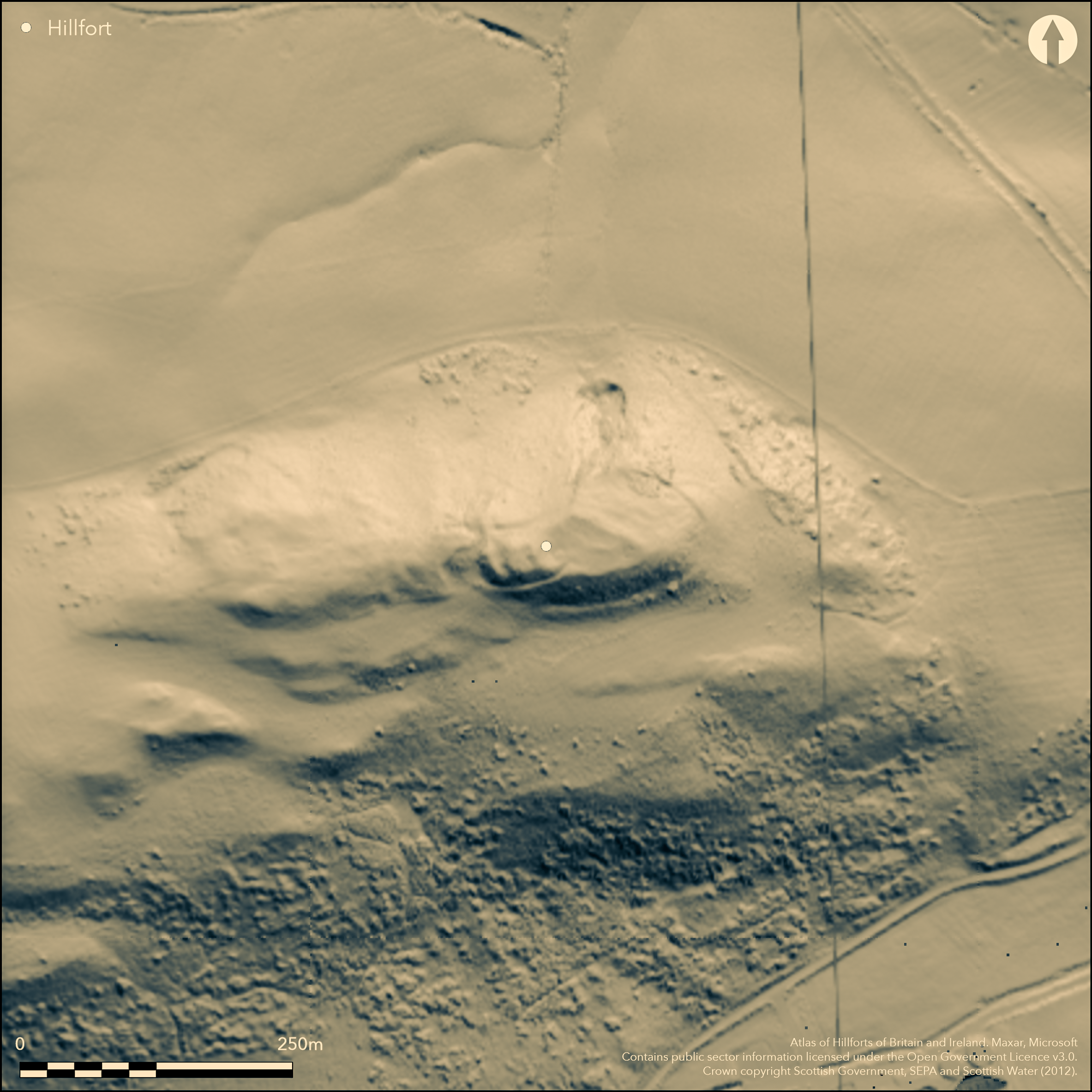
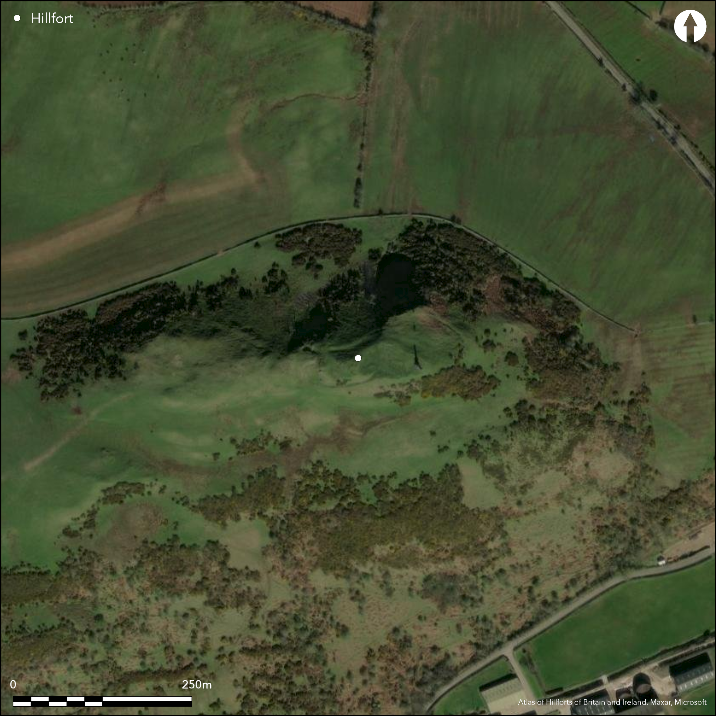
This fort is situated on the E end of a prominent ridge that rises out of the undulating landscape S of Maybole. Oval on plan, it measures about 46m from E to W by 23m transversely (0.08ha) within what has evidently been a heavily vitrified wall or rampart, though it has been extensively robbed on the W and SE, and is partly overlain by the monument to Sir Charles Fergusson of Kilkerran. Additional defence on the W is provided by two outer ramparts with external ditches, which cut across the spine of the ridge. The entrance is probably on the WSW, where a terraced trackway passes along the slope below the terminals of the two outer ramparts to approach a gap in the inner wall.
Citizen Science: ✓
Reliability of Data: Confirmed
Reliability of Interpretation: Confirmed
X: -521391 Y: 7426370 (EPSG: 3857)
Longitude: -4.683730588278108 Latitude: 55.33098409981624 (EPSG:4326)
Country: Scotland
Current County or Unitary Authority: South Ayrshire
Historic County: Ayrshire
Current Parish/Community/Council/Townland: Maybole
None
| Extant | ✓ |
| Cropmark | ✗ |
| Likely Destroyed | ✗ |
None
| Woodland | ✗ |
| Commercial Forestry Plantation | ✗ |
| Parkland | ✗ |
| Pasture (Grazing) | ✓ |
| Arable | ✗ |
| Scrub/Bracken | ✗ |
| Bare Outcrop | ✗ |
| Heather/Moorland | ✗ |
| Heath | ✗ |
| Built-up | ✗ |
| Coastal Grassland | ✗ |
| Other | ✗ |
None
| Contour Fort | ✓ |
| Partial Contour Fort | ✗ |
| Promontory Fort | ✗ |
| Hillslope Fort | ✗ |
| Level Terrain Fort | ✗ |
| Marsh Fort | ✗ |
| Multiple Enclosure Fort | ✗ |
| Hilltop | ✓ |
| Coastal Promontory | ✗ |
| Inland Promontory | ✗ |
| Valley Bottom | ✗ |
| Knoll/Hillock/Outcrop | ✗ |
| Ridge | ✗ |
| Cliff/Plateau-edge/Scarp | ✗ |
| Hillslope | ✗ |
| Lowland | ✗ |
| Spur | ✗ |
Dominant Topographic Feature: None
| North | ✗ |
| Northeast | ✗ |
| East | ✗ |
| Southeast | ✗ |
| South | ✗ |
| Southwest | ✗ |
| West | ✗ |
| Northwest | ✗ |
| Level | ✓ |
Altitude: 170.0m
N/A
In the absence of excavation, there are neither stratified artefacts nor radiocarbon dates to provide a chronology for the defences.
Reliability: D - None
| Pre 1200BC | ✗ |
| 1200BC - 800BC | ✗ |
| 800BC - 400BC | ✗ |
| 400BC - AD50 | ✗ |
| AD50 - AD400 | ✗ |
| AD400 - AD 800 | ✗ |
| Post AD800 | ✗ |
| Unknown | ✓ |
| Pre Hillfort: | None |
| Post Hillfort: | None |
First depicted in 1857 on the 1st edition OS 25-inch map (Ayrshire 1859, sheet 44.12), this fort was included unvisited in David Christison's survey of Ayrshire (1893, 396), but at about the same date noted in some detail by John Smith (1895, 178-9). It was then noted in 1942 for the RCAHMS Emergency Surveys by Angus Graham and Gordon Childe, who observed that the slightly odd configuration of the inner wall and the outer defences on the W might indicate that they belong to separate periods of construction (Childe and Graham 1943, 39-40). The fort was revisited by RCAHMS in 1953 during the Survey of Marginal Lands, and was resurveyed at 1:2500 by the OS in 1967, and again in 1977. RCAHMS revisited in 1982, and also took oblique aerial photographs in 1994. It was Scheduled in 1961.
| 1st Identified Map Depiction (1857): | Named in Gothic type on the 1st edition OS 25-inch map (Ayrshire 1859, sheet 44.12) |
| Other (1895): | Description, John Smith (1895, 178-9) |
| Other (1942): | Description by Angus Graham and Gordon Childe for RCAHMS wartime Emergency Surveys (Childe and Graham 1943, 39-40) |
| Other (1953): | Description during RCAHMS Survey of Marginal Lands |
| Other (1961): | Scheduled |
| Other (1967): | Resurveyed at 1:2500 by the OS |
| Other (1977): | Revised at 1:2500 by the OS |
| Other (1982): | Description by RCAHMS |
| Other (1983): | Visited by the Hill-Fort Study Group |
Featureless
None
| None | ✓ |
| Spring | ✗ |
| Stream | ✗ |
| Pool | ✗ |
| Flush | ✗ |
| Well | ✗ |
| Other | ✗ |
None
| No Known Features | ✓ |
| Round Stone Structures | ✗ |
| Rectangular Stone Structures | ✗ |
| Curvilinear Platforms | ✗ |
| Other Roundhouse Evidence | ✗ |
| Pits | ✗ |
| Quarry Hollows | ✗ |
| Other | ✗ |
None
| No Known Excavation | ✓ |
| Pits | ✗ |
| Postholes | ✗ |
| Roundhouses | ✗ |
| Rectangular Structures | ✗ |
| Roads/Tracks | ✗ |
| Quarry Hollows | ✗ |
| Other | ✗ |
| Nothing Found | ✗ |
None
| No Known Geophysics | ✓ |
| Pits | ✗ |
| Roundhouses | ✗ |
| Rectangular Structures | ✗ |
| Roads/Tracks | ✗ |
| Quarry Hollows | ✗ |
| Other | ✗ |
| Nothing Found | ✗ |
None
| No Known Finds | ✓ |
| Pottery | ✗ |
| Metal | ✗ |
| Metalworking | ✗ |
| Human Bones | ✗ |
| Animal Bones | ✗ |
| Lithics | ✗ |
| Environmental | ✗ |
| Other | ✗ |
NO APPARENT FEATURES
| APs Not Checked | ✗ |
| None | ✓ |
| Roundhouses | ✗ |
| Rectangular Structures | ✗ |
| Pits | ✗ |
| Postholes | ✗ |
| Roads/Tracks | ✗ |
| Other | ✗ |
See main summary
| 1: | Heavy robbing in large sectors of the inner wall |
| 2: | None |
Guard Chambers: ✗
Chevaux de Frise: ✗
| 1. Simple Gap (South west): | None |
One continuous wall and two outer ramparts and ditches on the most accessible side
| Area 1: | 0.07ha. |
| Total: | 0.07ha. |
Total Footprint Area: 0.2ha.
None
| ✗ | None |
| ✓ | None |
| NE Quadrant: | 1 |
| SE Quadrant: | 1 |
| SW Quadrant: | 3 |
| NW Quadrant: | 1 |
| Total: | 3 |
| Partial Univallate | ✓ |
| Univallate | ✗ |
| Partial Bivallate | ✗ |
| Bivallate | ✗ |
| Partial Multivallate | ✓ |
| Multivallate | ✗ |
| Unknown | ✗ |
| Partial Univallate | ✗ |
| Univallate | ✗ |
| Partial Bivallate | ✗ |
| Bivallate | ✗ |
| Partial Multivallate | ✗ |
| Multivallate | ✗ |
None
| None | ✗ |
| Earthen Bank | ✓ |
| Stone Wall | ✗ |
| Rubble | ✓ |
| Wall-walk | ✗ |
| Evidence of Timber | ✗ |
| Vitrification | ✓ |
| Other Burning | ✗ |
| Palisade | ✗ |
| Counter Scarp Bank | ✗ |
| Berm | ✗ |
| Unfinished | ✗ |
| Other | ✗ |
None
| None | ✗ |
| Earthen Bank | ✗ |
| Stone Wall | ✗ |
| Murus Duplex | ✗ |
| Timber-framed | ✗ |
| Timber-laced | ✗ |
| Vitrification | ✗ |
| Other Burning | ✗ |
| Palisade | ✗ |
| Counter Scarp Bank | ✗ |
| Berm | ✗ |
| Unfinished | ✗ |
| No Known Excavation | ✓ |
| Other | ✗ |
| ✗ | None |
| ✓ | On one side |
Number of Ditches: 2
| ✗ | None |
Childe and Graham, V G and A (1943) 'Some notable prehistoric and medieval monuments recently examined by The Royal Commission on Ancient and Historical Monuments of Scotland', Proc Soc Antiq Scot 77 (1943), 31-49
Christison, D (1893) 'The Prehistoric Forts of Ayrshire'. Proc Soc Antiq Scot 27 (1892-93), 381-405.
Feachem, R (1963) A guide to prehistoric Scotland. Batsford: London (p 109-10)
Smith, J (1895) Prehistoric Man in Ayrshire. London.
Atlas of Hillforts:
Wikidata:
This work is licensed under CC BY-SA 4.0![]()
![]()
![]() and should be cited as:
and should be cited as:
Lock, Gary and Ralston, Ian. 2024. Atlas of Hillforts of Britain and Ireland. Available at: https://hillforts.arch.ox.ac.uk
Document Version 1.1