LiDAR 1m DTM Hillshade
Satellite Imagery
LiDAR 1m DTM Hillshade
Satellite Imagery
Scroll left/right to view further images.
HER: The West of Scotland Archaeology Service 5574 (None)
NMR: NS 24 NW 10 (40997)
SM: None
NGR: NS 2031 4715
X: 220310 Y: 647150 (OSGB36)
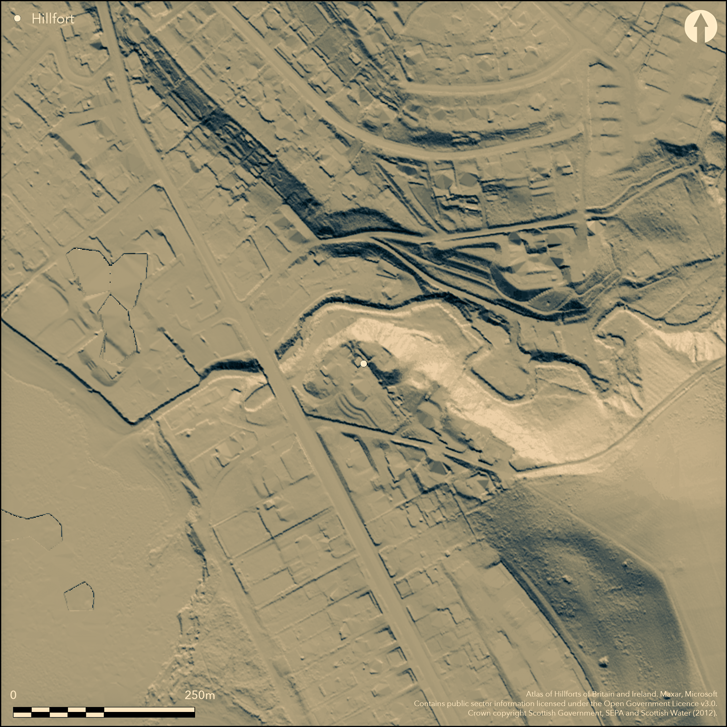
This small fort occupies a steep-sided hillock that forms the NW extremity of a promontory on the S bank of the Kilbride Burn not far above the point where it debouches onto the shore. The construction of a large house in the late 1880s or early 1890s has bitten back into the SW flank of the fort, and the surrounding area has also been subjected to varying degrees of landscaping to create a garden. Thus the top of the hillock has been levelled to form a lawn, emphasising the height of the rampart surviving at its SE end, which is about 3m in thickness and stands to height of about 3m internally; it falls away externally here into a shallow hollow separating the hillock from the spine of the promontory. Elsewhere the ground drops steeply on all sides, and while the rampart can be seen to turn back along the NE flank, nothing of it is visible elsewhere. According to a plan drawn up by Robert Munro following the excavations of 1880, two walls were found along the SW flank of the knoll, each 'about 5 or 6 feet thick, and only a few yards apart', but in view of the scale of the rampart at the SE end it is possible that these were no more than the inner and outer faces of the same thick wall, which came together at the NW end. From his plan, the interior measures about 30m from NW to SE by 12m transversely (0.03ha) and in its SE end they found a substantial stone structure with a paved floor. Most of the finds, which included a rotary quern several pieces of worked shale and artefacts of iron, bronze and glass, a bronze stud and several sherds of Roman wares, came from within this structure. Evidently domestic, it is unclear whether it represent the remains of a round-house or, possibly a more substantial dun inserted into an earlier fortification.
Citizen Science: ✓
Reliability of Data: Confirmed
Reliability of Interpretation: Confirmed
X: -540997 Y: 7495864 (EPSG: 3857)
Longitude: -4.8598578339229075 Latitude: 55.68450256390989 (EPSG:4326)
Country: Scotland
Current County or Unitary Authority: North Ayrshire
Historic County: Ayrshire
Current Parish/Community/Council/Townland: West Kilbride
None
| Extant | ✓ |
| Cropmark | ✗ |
| Likely Destroyed | ✓ |
Garden ground
| Woodland | ✓ |
| Commercial Forestry Plantation | ✗ |
| Parkland | ✗ |
| Pasture (Grazing) | ✗ |
| Arable | ✗ |
| Scrub/Bracken | ✗ |
| Bare Outcrop | ✗ |
| Heather/Moorland | ✗ |
| Heath | ✗ |
| Built-up | ✓ |
| Coastal Grassland | ✗ |
| Other | ✗ |
None
| Contour Fort | ✗ |
| Partial Contour Fort | ✗ |
| Promontory Fort | ✓ |
| Hillslope Fort | ✗ |
| Level Terrain Fort | ✗ |
| Marsh Fort | ✗ |
| Multiple Enclosure Fort | ✗ |
| Hilltop | ✗ |
| Coastal Promontory | ✗ |
| Inland Promontory | ✓ |
| Valley Bottom | ✗ |
| Knoll/Hillock/Outcrop | ✗ |
| Ridge | ✗ |
| Cliff/Plateau-edge/Scarp | ✗ |
| Hillslope | ✗ |
| Lowland | ✗ |
| Spur | ✗ |
Dominant Topographic Feature: None
| North | ✗ |
| Northeast | ✗ |
| East | ✗ |
| Southeast | ✗ |
| South | ✗ |
| Southwest | ✗ |
| West | ✗ |
| Northwest | ✗ |
| Level | ✓ |
Altitude: 15.0m
N/A
The finds recovered here do not necessarily relate to the construction of defences
Reliability: C - Low
| Pre 1200BC | ✗ |
| 1200BC - 800BC | ✗ |
| 800BC - 400BC | ✗ |
| 400BC - AD50 | ✗ |
| AD50 - AD400 | ✓ |
| AD400 - AD 800 | ✗ |
| Post AD800 | ✗ |
| Unknown | ✗ |
| Pre Hillfort: | None |
| Post Hillfort: | None |
| Artefactual: | Roman good |
First noted in the New Statistical Account in 1837 (NSA 5, Ayrshire, 257-8), it is depicted on the 1st edition OS 25-inch map (Ayrshire 1858, sheet 10.12), and in 1880 was selected for excavation by the Ayrshire and Wigtownshire Archaeological Association (Munro 1882, 60). It was subsequently visited in the early 1890s by David Christison (1893, 397) and John Smith (1895, 7-8). It was visited in 1952 by RCAHMS as part of the Survey of Marginal Lands and by the OS in 1956, 1964 and 1982. A watching brief was carried out in 2010 (Turner 2010).
| 1st Identified Written Reference (1837): | Noted (NSA 5, Ayrshire, 257-8) |
| 1st Identified Map Depiction (1858): | Annotated Fort on the 1st edition OS 25-inch map (Ayrshire 1858, sheet 10.12) |
| Excavation (1880): | Party from the Ayrshire and Wigtownshire Archaeological Association with a gang of workmen (Munro 1882) |
| Other (1893): | Description by David Christison (1893, 397) |
| Other (1895): | Description by John Smith (1895, 7-8) |
| Other (1952): | Description during RCAHMS Survey of Marginal Lands |
| Other (1956): | Visited by the OS |
| Other (1964): | Resurveyed at 1:2500 by the OS |
| Other (1982): | Visited by the OS |
| Excavation (2010): | Turner 2010 |
Now featureless, but evidently partly occupied by a substantial structure
None
| None | ✓ |
| Spring | ✗ |
| Stream | ✗ |
| Pool | ✗ |
| Flush | ✗ |
| Well | ✗ |
| Other | ✗ |
None
| No Known Features | ✓ |
| Round Stone Structures | ✗ |
| Rectangular Stone Structures | ✗ |
| Curvilinear Platforms | ✗ |
| Other Roundhouse Evidence | ✗ |
| Pits | ✗ |
| Quarry Hollows | ✗ |
| Other | ✗ |
Paving and structural remains found in an antiquarian excavation.
| No Known Excavation | ✗ |
| Pits | ✗ |
| Postholes | ✗ |
| Roundhouses | ✗ |
| Rectangular Structures | ✗ |
| Roads/Tracks | ✗ |
| Quarry Hollows | ✗ |
| Other | ✓ |
| Nothing Found | ✗ |
None
| No Known Geophysics | ✓ |
| Pits | ✗ |
| Roundhouses | ✗ |
| Rectangular Structures | ✗ |
| Roads/Tracks | ✗ |
| Quarry Hollows | ✗ |
| Other | ✗ |
| Nothing Found | ✗ |
None
| No Known Finds | ✗ |
| Pottery | ✗ |
| Metal | ✓ |
| Metalworking | ✗ |
| Human Bones | ✗ |
| Animal Bones | ✗ |
| Lithics | ✗ |
| Environmental | ✗ |
| Other | ✓ |
NO APPARENT FEATURES; obscured by trees
| APs Not Checked | ✗ |
| None | ✓ |
| Roundhouses | ✗ |
| Rectangular Structures | ✗ |
| Pits | ✗ |
| Postholes | ✗ |
| Roads/Tracks | ✗ |
| Other | ✗ |
See main summary
| 0: | Extensively demolished |
| 2: | None reliably recorded |
Guard Chambers: ✗
Chevaux de Frise: ✗
One or two wallls
| Area 1: | 0.03ha. |
| Total: | 0.03ha. |
Total Footprint Area: Noneha.
None
| ✗ | None |
| ✗ | None |
| NE Quadrant: | 0 |
| SE Quadrant: | 1 |
| SW Quadrant: | 1 |
| NW Quadrant: | 0 |
| Total: | 1 |
| Partial Univallate | ✓ |
| Univallate | ✗ |
| Partial Bivallate | ✗ |
| Bivallate | ✗ |
| Partial Multivallate | ✗ |
| Multivallate | ✗ |
| Unknown | ✗ |
| Partial Univallate | ✗ |
| Univallate | ✗ |
| Partial Bivallate | ✗ |
| Bivallate | ✗ |
| Partial Multivallate | ✗ |
| Multivallate | ✗ |
None
| None | ✗ |
| Earthen Bank | ✗ |
| Stone Wall | ✗ |
| Rubble | ✓ |
| Wall-walk | ✗ |
| Evidence of Timber | ✗ |
| Vitrification | ✗ |
| Other Burning | ✗ |
| Palisade | ✗ |
| Counter Scarp Bank | ✗ |
| Berm | ✗ |
| Unfinished | ✗ |
| Other | ✗ |
No clear record of the walls
| None | ✗ |
| Earthen Bank | ✗ |
| Stone Wall | ✓ |
| Murus Duplex | ✗ |
| Timber-framed | ✗ |
| Timber-laced | ✗ |
| Vitrification | ✗ |
| Other Burning | ✗ |
| Palisade | ✗ |
| Counter Scarp Bank | ✗ |
| Berm | ✗ |
| Unfinished | ✗ |
| No Known Excavation | ✗ |
| Other | ✗ |
| ✗ | None |
| ✗ | Probably a natural hollow on the SE |
Number of Ditches: None
| ✗ | None |
Christison, D (1893) 'The Prehistoric Forts of Ayrshire'. Proc Soc Antiq Scot 27 (1892-93), 381-405.
Munro, R (1882e) 'Notice of excavations made on an ancient "fort" at Seamill, Ayrshire', Archaeol Hist Collect Ayr Wigton 3 (1882), 59-65
NSA (1834-1845) The new statistical account of Scotland by the ministers of the respective parishes under the superintendence of a committee of the society for the benefit of the sons and daughters of the clergy, 15v Edinburgh
Smith, J (1895) Prehistoric Man in Ayrshire. London.
Turner, L (2010g) '56a Ardrossan Road, Seamill, North Ayrshire (West Kilbride parish), watching brief', Discovery Excav Scot, New ser, 11 (2010), 118
Atlas of Hillforts:
Wikidata:
This work is licensed under CC BY-SA 4.0![]()
![]()
![]() and should be cited as:
and should be cited as:
Lock, Gary and Ralston, Ian. 2024. Atlas of Hillforts of Britain and Ireland. Available at: https://hillforts.arch.ox.ac.uk
Document Version 1.1