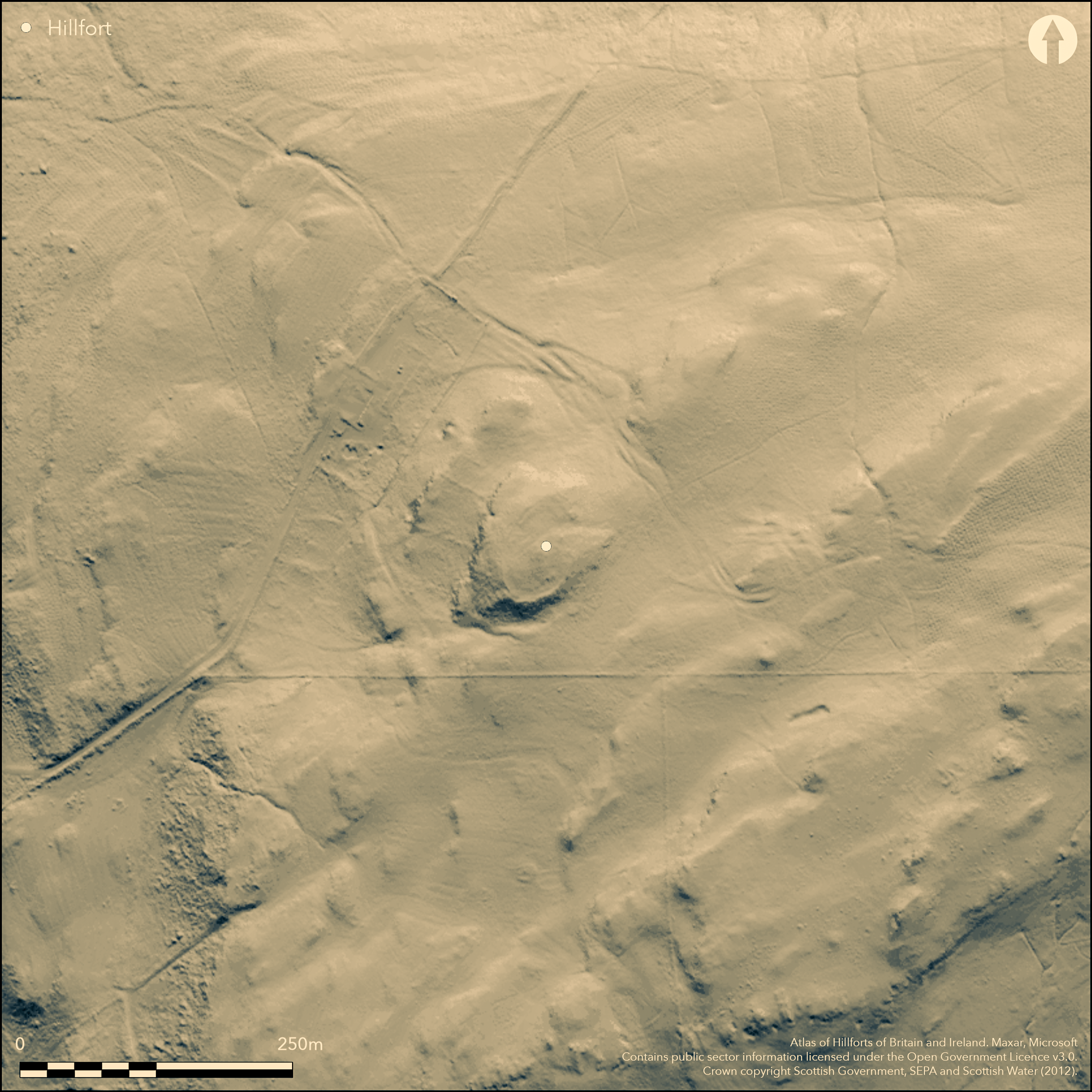
LiDAR 1m DTM Hillshade

Satellite Imagery
LiDAR 1m DTM Hillshade
Satellite Imagery
Scroll left/right to view further images.
HER: The West of Scotland Archaeology Service 5741 (None)
NMR: NS 25 NW 2 (41166)
SM: 10390
NGR: NS 2156 5880
X: 221565 Y: 658800 (OSGB36)
This fort is situated on a steep-sided hillock on the hillside dropping down to Largs on the S side of Gogo Glen. Oval on plan, it measures about 50m from NNE to SSW by 33m transversely (0.13ha) within a heavily robbed rampart, which forms a bank about 2m in thickness and 1m in external height around the S, but elsewhere is marked by little more than a robbing scar. The entrance is on the NE, opening onto a natural gully in this flank of the hillock. The rocky interior is featureless. An external ditch noted by most investigators at the foot of the hillock on the S is almost certainly a misidentification of a hollowed trackway that can be seen climbing the slope on this side of the fort, while others are braided into a complex pattern on the northern flank.
Citizen Science: ✓
Reliability of Data: Confirmed
Reliability of Interpretation: Confirmed
X: -539625 Y: 7516628 (EPSG: 3857)
Longitude: -4.847529819392664 Latitude: 55.789514814152135 (EPSG:4326)
Country: Scotland
Current County or Unitary Authority: North Ayrshire
Historic County: Ayrshire
Current Parish/Community/Council/Townland: Largs
None
| Extant | ✓ |
| Cropmark | ✗ |
| Likely Destroyed | ✗ |
None
| Woodland | ✗ |
| Commercial Forestry Plantation | ✗ |
| Parkland | ✗ |
| Pasture (Grazing) | ✓ |
| Arable | ✗ |
| Scrub/Bracken | ✗ |
| Bare Outcrop | ✗ |
| Heather/Moorland | ✓ |
| Heath | ✗ |
| Built-up | ✗ |
| Coastal Grassland | ✗ |
| Other | ✗ |
None
| Contour Fort | ✓ |
| Partial Contour Fort | ✗ |
| Promontory Fort | ✗ |
| Hillslope Fort | ✗ |
| Level Terrain Fort | ✗ |
| Marsh Fort | ✗ |
| Multiple Enclosure Fort | ✗ |
| Hilltop | ✗ |
| Coastal Promontory | ✗ |
| Inland Promontory | ✗ |
| Valley Bottom | ✗ |
| Knoll/Hillock/Outcrop | ✓ |
| Ridge | ✗ |
| Cliff/Plateau-edge/Scarp | ✗ |
| Hillslope | ✗ |
| Lowland | ✗ |
| Spur | ✗ |
Dominant Topographic Feature: None
| North | ✗ |
| Northeast | ✗ |
| East | ✗ |
| Southeast | ✗ |
| South | ✗ |
| Southwest | ✗ |
| West | ✗ |
| Northwest | ✗ |
| Level | ✓ |
Altitude: 180.0m
N/A
In the absence of excavation, there are neither stratified artefacts nor radiocarbon dates to provide a chronology for the defences.
Reliability: D - None
| Pre 1200BC | ✗ |
| 1200BC - 800BC | ✗ |
| 800BC - 400BC | ✗ |
| 400BC - AD50 | ✗ |
| AD50 - AD400 | ✗ |
| AD400 - AD 800 | ✗ |
| Post AD800 | ✗ |
| Unknown | ✓ |
| Pre Hillfort: | None |
| Post Hillfort: | None |
First depicted in 1855 (Ayrshire 1857, sheet 3.12), it was visited by both David Christison and John Smith in the early 1890s (Christison 1893, 401; Smith 1895, 4). It was subsequently visited in 1942 as part of the RCAHMS Emergency Surveys, and again in 1952 for the Survey of Marginal Lands. The OS revised the 1:2500 survey in 1964, and revisited in 1983. It was Scheduled in 2002.
| 1st Identified Map Depiction (1855): | Named in Gothic type on the 1st edition OS 25-inch map (Ayrshire 1860, sheet 16.1) |
| Other (1891): | Description by David Christison (1893, 401) |
| Other (1895): | Description by John Smith (1895, 4) |
| Other (1942): | Visiterd by Angus Graham and Gordon Childe for the RCAHMS wartime Emergency Surveys |
| Other (1952): | Description for RCAHMS Survey of Marginal Lands |
| Other (1964): | Surveyed at 1:2500 by the OS |
| Other (1983): | Visited by the OS |
| Other (2002): | Scheduled |
Featureless
None
| None | ✓ |
| Spring | ✗ |
| Stream | ✗ |
| Pool | ✗ |
| Flush | ✗ |
| Well | ✗ |
| Other | ✗ |
None
| No Known Features | ✓ |
| Round Stone Structures | ✗ |
| Rectangular Stone Structures | ✗ |
| Curvilinear Platforms | ✗ |
| Other Roundhouse Evidence | ✗ |
| Pits | ✗ |
| Quarry Hollows | ✗ |
| Other | ✗ |
None
| No Known Excavation | ✓ |
| Pits | ✗ |
| Postholes | ✗ |
| Roundhouses | ✗ |
| Rectangular Structures | ✗ |
| Roads/Tracks | ✗ |
| Quarry Hollows | ✗ |
| Other | ✗ |
| Nothing Found | ✗ |
None
| No Known Geophysics | ✓ |
| Pits | ✗ |
| Roundhouses | ✗ |
| Rectangular Structures | ✗ |
| Roads/Tracks | ✗ |
| Quarry Hollows | ✗ |
| Other | ✗ |
| Nothing Found | ✗ |
None
| No Known Finds | ✓ |
| Pottery | ✗ |
| Metal | ✗ |
| Metalworking | ✗ |
| Human Bones | ✗ |
| Animal Bones | ✗ |
| Lithics | ✗ |
| Environmental | ✗ |
| Other | ✗ |
NO APPARENT FEATURES
| APs Not Checked | ✗ |
| None | ✓ |
| Roundhouses | ✗ |
| Rectangular Structures | ✗ |
| Pits | ✗ |
| Postholes | ✗ |
| Roads/Tracks | ✗ |
| Other | ✗ |
See main summary
| 1: | None |
| 2: | None |
Guard Chambers: ✗
Chevaux de Frise: ✗
| 1. Simple Gap (North east): | Hollowed approach via a gully. |
Single rampart
| Area 1: | 0.13ha. |
| Total: | 0.13ha. |
Total Footprint Area: Noneha.
None
| ✗ | None |
| ✓ | None |
| NE Quadrant: | 1 |
| SE Quadrant: | 1 |
| SW Quadrant: | 1 |
| NW Quadrant: | 1 |
| Total: | 1 |
| Partial Univallate | ✗ |
| Univallate | ✓ |
| Partial Bivallate | ✗ |
| Bivallate | ✗ |
| Partial Multivallate | ✗ |
| Multivallate | ✗ |
| Unknown | ✗ |
| Partial Univallate | ✗ |
| Univallate | ✗ |
| Partial Bivallate | ✗ |
| Bivallate | ✗ |
| Partial Multivallate | ✗ |
| Multivallate | ✗ |
Grass-grown rubble bank
| None | ✗ |
| Earthen Bank | ✗ |
| Stone Wall | ✗ |
| Rubble | ✓ |
| Wall-walk | ✗ |
| Evidence of Timber | ✗ |
| Vitrification | ✗ |
| Other Burning | ✗ |
| Palisade | ✗ |
| Counter Scarp Bank | ✗ |
| Berm | ✗ |
| Unfinished | ✗ |
| Other | ✗ |
None
| None | ✗ |
| Earthen Bank | ✗ |
| Stone Wall | ✗ |
| Murus Duplex | ✗ |
| Timber-framed | ✗ |
| Timber-laced | ✗ |
| Vitrification | ✗ |
| Other Burning | ✗ |
| Palisade | ✗ |
| Counter Scarp Bank | ✗ |
| Berm | ✗ |
| Unfinished | ✗ |
| No Known Excavation | ✓ |
| Other | ✗ |
| ✗ | None |
| ✗ | None |
Number of Ditches: None
| ✗ | None |
Christison, D (1893) 'The prehistoric forts of Ayrshire'. Proc Soc Antiq Scot 27, 381-405
Smith, J (1895) Prehistoric man in Ayrshire. London
Atlas of Hillforts:
Wikidata:
This work is licensed under CC BY-SA 4.0![]()
![]()
![]() and should be cited as:
and should be cited as:
Lock, Gary and Ralston, Ian. 2024. Atlas of Hillforts of Britain and Ireland. Available at: https://hillforts.arch.ox.ac.uk
Document Version 1.1