LiDAR 1m DTM Hillshade
Satellite Imagery
LiDAR 1m DTM Hillshade
Satellite Imagery
Scroll left/right to view further images.
HER: The West of Scotland Archaeology Service 6556 (None)
NMR: NS 33 SE 5 (41985)
SM: 306
NGR: NS 3592 3276
X: 235920 Y: 632760 (OSGB36)
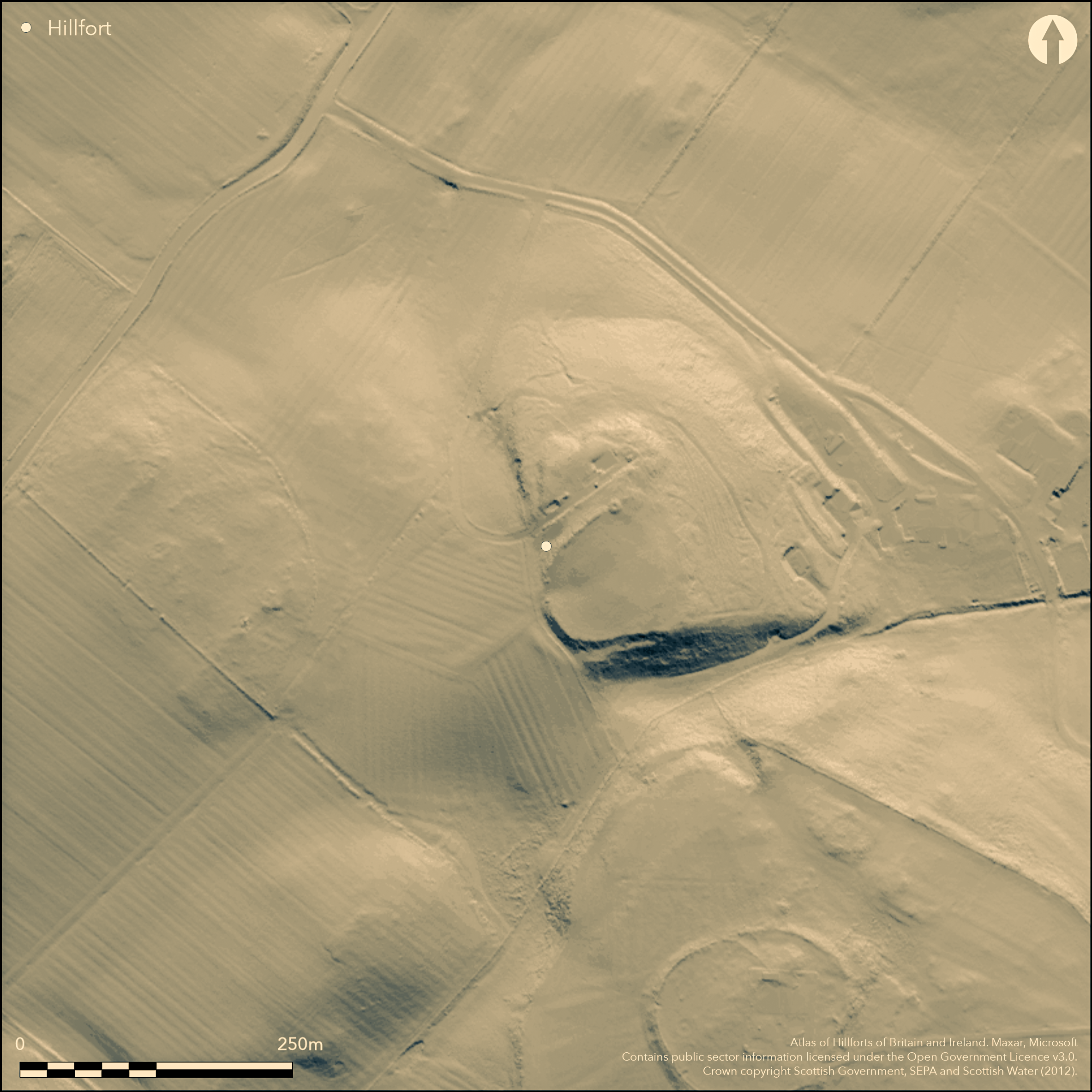
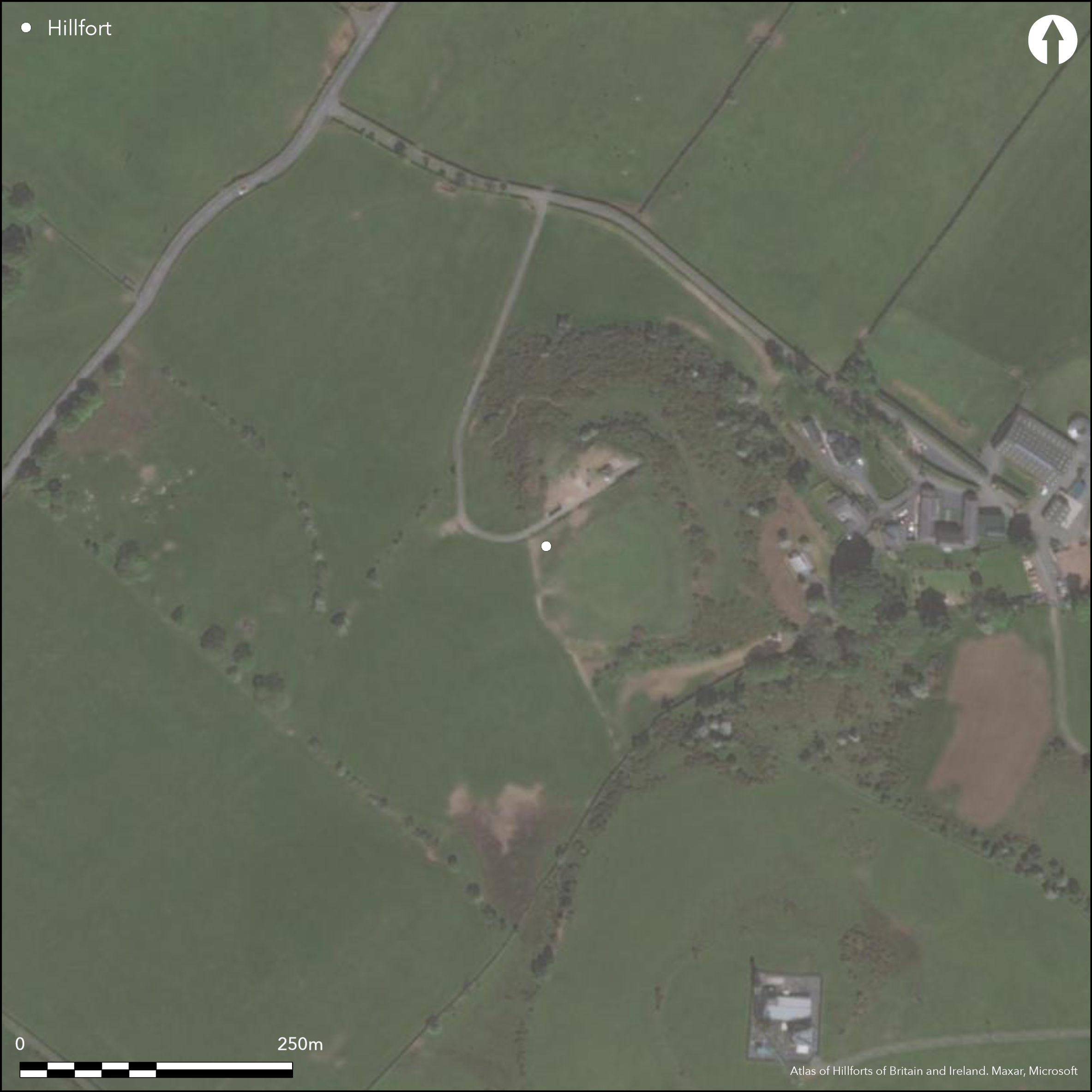
The remains of this fort are situated on the summit of Wardlaw Hill, but its defences are heavily reduced by cultivation, so much so that the precise course of the eastern half is unknown. Nevertheless, the interior is probably oval on plan, measuring up to 95m from NE to SW by 60m transversely within a rampart up to 4.5m in thickness by 0.6m in height. This is best preserved on the NW, but can be traced as a scarp some 2.5m in height around the SW quarter, where there is also evidence of a ditch 4.5m in breadth and a counterscarp rampart 5m in thickness by 0.5m in height. The interior is featureless and the position of the entrance is unknown. A trial excavation on the NW in 1985 demonstrated that the rampart is constructed of earth and stone and overlies an earlier bank, which was already heavily denuded and spread at the time of the rampart's construction (Halpin 1992, 121-6). The earlier bank seems to have been constructed of material stripped from the surfaces both inside and outside its line, whereas the later rampart had a core of large stones and boulders. The excavator suggested that two narrow, stone-lined trenches set about 2m apart immediately within the interior may have held upright timbers revetting the rampart, but while these were apparently cut through deposits washed off the earlier bank there is no compelling evidence to relate them to the structure of the rampart, nor indeed that they held timberwork.
Citizen Science: ✓
Reliability of Data: Confirmed
Reliability of Interpretation: Confirmed
X: -512434 Y: 7471489 (EPSG: 3857)
Longitude: -4.603274108139964 Latitude: 55.56086621777508 (EPSG:4326)
Country: Scotland
Current County or Unitary Authority: South Ayrshire
Historic County: Ayrshire
Current Parish/Community/Council/Townland: Dundonald
None
| Extant | ✓ |
| Cropmark | ✗ |
| Likely Destroyed | ✓ |
None
| Woodland | ✗ |
| Commercial Forestry Plantation | ✗ |
| Parkland | ✗ |
| Pasture (Grazing) | ✓ |
| Arable | ✗ |
| Scrub/Bracken | ✗ |
| Bare Outcrop | ✗ |
| Heather/Moorland | ✗ |
| Heath | ✗ |
| Built-up | ✗ |
| Coastal Grassland | ✗ |
| Other | ✗ |
None
| Contour Fort | ✓ |
| Partial Contour Fort | ✗ |
| Promontory Fort | ✗ |
| Hillslope Fort | ✗ |
| Level Terrain Fort | ✗ |
| Marsh Fort | ✗ |
| Multiple Enclosure Fort | ✗ |
| Hilltop | ✓ |
| Coastal Promontory | ✗ |
| Inland Promontory | ✗ |
| Valley Bottom | ✗ |
| Knoll/Hillock/Outcrop | ✗ |
| Ridge | ✗ |
| Cliff/Plateau-edge/Scarp | ✗ |
| Hillslope | ✗ |
| Lowland | ✗ |
| Spur | ✗ |
Dominant Topographic Feature: None
| North | ✗ |
| Northeast | ✗ |
| East | ✗ |
| Southeast | ✗ |
| South | ✗ |
| Southwest | ✗ |
| West | ✗ |
| Northwest | ✗ |
| Level | ✓ |
Altitude: 145.0m
N/A
No dating evidence was recovered for the defences
Reliability: D - None
| Pre 1200BC | ✗ |
| 1200BC - 800BC | ✗ |
| 800BC - 400BC | ✗ |
| 400BC - AD50 | ✗ |
| AD50 - AD400 | ✗ |
| AD400 - AD 800 | ✗ |
| Post AD800 | ✗ |
| Unknown | ✓ |
| Pre Hillfort: | Pit cut into the land surface beneath the earlier bank |
| Post Hillfort: | Ploughed down |
First depicted in 1857 on the 1st edition OS 25-inch map (Ayrshire 1860, sheet 22.11), it was described in the early 1890s by both David Christison (Christison 1893, 393, pl vi fig 2) and John Smith (Smith 1895, 120-1). RCAHMS visited the fort in 1952 during its survey of Marginal Lands and it was Scheduled in 1953. The OS visited in 1954 and revised the 1:2500 depiction in 1982. RCAHMS revisited it in 1985 and in the same year an evaluation trench was excavated across the defences on the NW (Halpin 1992).
| 1st Identified Map Depiction (1857): | Annotated Intrenchment on the 1st edition OS 25-inch map (Ayrshire 1860, sheet 22.11) |
| Earthwork Survey (1891): | Sketch-plan and description (Christison 1893, 390 fig 2, 393) |
| Other (1895): | Description by John Smith (1895, 120-1) |
| Other (1952): | Description during RCAHMS Survey of Marginal Lands |
| Other (1953): | Scheduled |
| Other (1954): | Visited by the OS |
| Other (1982): | Revised at 1:2500 by the OS |
| Excavation (1985): | Evaluation (Halpin 1992) |
| Other (1985): | Description by RCAHMS |
Featureless
None
| None | ✓ |
| Spring | ✗ |
| Stream | ✗ |
| Pool | ✗ |
| Flush | ✗ |
| Well | ✗ |
| Other | ✗ |
None
| No Known Features | ✓ |
| Round Stone Structures | ✗ |
| Rectangular Stone Structures | ✗ |
| Curvilinear Platforms | ✗ |
| Other Roundhouse Evidence | ✗ |
| Pits | ✗ |
| Quarry Hollows | ✗ |
| Other | ✗ |
None
| No Known Excavation | ✗ |
| Pits | ✗ |
| Postholes | ✗ |
| Roundhouses | ✗ |
| Rectangular Structures | ✗ |
| Roads/Tracks | ✗ |
| Quarry Hollows | ✗ |
| Other | ✗ |
| Nothing Found | ✓ |
None
| No Known Geophysics | ✓ |
| Pits | ✗ |
| Roundhouses | ✗ |
| Rectangular Structures | ✗ |
| Roads/Tracks | ✗ |
| Quarry Hollows | ✗ |
| Other | ✗ |
| Nothing Found | ✗ |
None
| No Known Finds | ✓ |
| Pottery | ✗ |
| Metal | ✗ |
| Metalworking | ✗ |
| Human Bones | ✗ |
| Animal Bones | ✗ |
| Lithics | ✗ |
| Environmental | ✗ |
| Other | ✗ |
NO APPARENT FEATURES
| APs Not Checked | ✗ |
| None | ✓ |
| Roundhouses | ✗ |
| Rectangular Structures | ✗ |
| Pits | ✗ |
| Postholes | ✗ |
| Roads/Tracks | ✗ |
| Other | ✗ |
None known
| 0: | Large sectors ploughed down |
| 2: | No entrance known |
Guard Chambers: ✗
Chevaux de Frise: ✗
Twin ramparts with a medial ditch on the SW, but only one rampart elsewhere. Rampart shown to have been constructed in at least two phases
| Area 1: | 0.4ha. |
| Total: | 0.4ha. |
Total Footprint Area: Noneha.
None
| ✓ | None |
| ✓ | None |
| NE Quadrant: | 1 |
| SE Quadrant: | 1 |
| SW Quadrant: | 2 |
| NW Quadrant: | 1 |
| Total: | 2 |
| Partial Univallate | ✓ |
| Univallate | ✗ |
| Partial Bivallate | ✓ |
| Bivallate | ✗ |
| Partial Multivallate | ✗ |
| Multivallate | ✗ |
| Unknown | ✗ |
| Partial Univallate | ✗ |
| Univallate | ✗ |
| Partial Bivallate | ✗ |
| Bivallate | ✗ |
| Partial Multivallate | ✗ |
| Multivallate | ✗ |
None
| None | ✗ |
| Earthen Bank | ✓ |
| Stone Wall | ✗ |
| Rubble | ✗ |
| Wall-walk | ✗ |
| Evidence of Timber | ✗ |
| Vitrification | ✗ |
| Other Burning | ✗ |
| Palisade | ✗ |
| Counter Scarp Bank | ✗ |
| Berm | ✗ |
| Unfinished | ✗ |
| Other | ✗ |
Stone-lined trenches immediately within the line of the rampart were interpreted as palisade trenches or revetments, but in the case of the outer the timbers would have been of the order of 0.6m in thickness, a scale otherwise unknown in the timberwork of Scottish hillforts. Stratigraphically they possibly represent much later activity, perhaps even the result of post-medieval agriculture. Rampart has two phases - earther bank, then rubble core.
| None | ✗ |
| Earthen Bank | ✓ |
| Stone Wall | ✗ |
| Murus Duplex | ✗ |
| Timber-framed | ✗ |
| Timber-laced | ✗ |
| Vitrification | ✗ |
| Other Burning | ✗ |
| Palisade | ✗ |
| Counter Scarp Bank | ✗ |
| Berm | ✗ |
| Unfinished | ✗ |
| No Known Excavation | ✗ |
| Other | ✓ |
| ✗ | None |
| ✓ | None |
Number of Ditches: 1
| ✗ | None |
Christison, D (1893) 'The Prehistoric Forts of Ayrshire'. Proc Soc Antiq Scot 27 (1892-93), 381-405.
Feachem, R (1963) A guide to prehistoric Scotland. Batsford: London (p 110)
Halpin E 1992 'Harpercroft and Wardlaw hill', in Rideout, J S, Owen, O A, & Halpin, E (eds) 'Hillforts of southern Scotland'. Edinburgh, pp.121-6
Smith, J (1895) Prehistoric Man in Ayrshire. London.
Atlas of Hillforts:
Wikidata:
This work is licensed under CC BY-SA 4.0![]()
![]()
![]() and should be cited as:
and should be cited as:
Lock, Gary and Ralston, Ian. 2024. Atlas of Hillforts of Britain and Ireland. Available at: https://hillforts.arch.ox.ac.uk
Document Version 1.1