Satellite Imagery
Satellite Imagery
HER: The West of Scotland Archaeology Service 6557 (None)
NMR: NS 33 SE 6 (41986)
SM: 307
NGR: NS 3600 3252
X: 236000 Y: 632520 (OSGB36)
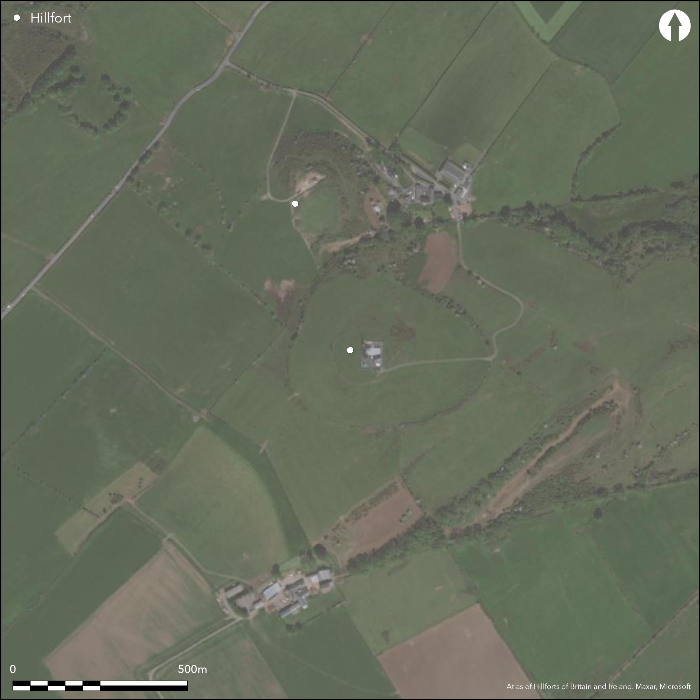
This fort comprises an inner and outer enclosure taking in the whole of the summit of the hilltop immediately S of Wardlaw Hill. Slightly oval on plan, the inner enclosure measures 105m from E to W by 90m transversely (0.7ha) within a rampart that follows a natural shoulder around most of the summit area to form a stony scarp about 1.6m in height; the crest of the rampart has itself provided the line for a later stone dyke. The outer enclosure follows a similar natural feature everywhere except on the SW, enclosing an area measuring about 320m from E to W by 260m transversely (6.5ha). The circuits of both ramparts are heavily denuded, with several large gaps, particularly where the track servicing the radio-station approaches from the E. Work in advance of the modernisation of the radio-station in 1985 recorded profiles across the inner rampart, which measures about 5m in thickness by 0.5m in height, and excavated an area within the interior, identifying the arcs of several shallow ditches, though their date and purpose were not determined (Halpin 1992). Finds included a small assemblage of pottery (mainly from one vessel) and five fragments of at least three shale bracelets and several pieces of unworked shale.
Citizen Science: ✓
Reliability of Data: Confirmed
Reliability of Interpretation: Confirmed
X: -512277 Y: 7471070 (EPSG: 3857)
Longitude: -4.60186460295015 Latitude: 55.558738841066685 (EPSG:4326)
Country: Scotland
Current County or Unitary Authority: South Ayrshire
Historic County: Ayrshire
Current Parish/Community/Council/Townland: Dundonald
None
| Extant | ✓ |
| Cropmark | ✗ |
| Likely Destroyed | ✓ |
None
| Woodland | ✗ |
| Commercial Forestry Plantation | ✗ |
| Parkland | ✗ |
| Pasture (Grazing) | ✓ |
| Arable | ✓ |
| Scrub/Bracken | ✗ |
| Bare Outcrop | ✗ |
| Heather/Moorland | ✗ |
| Heath | ✗ |
| Built-up | ✓ |
| Coastal Grassland | ✗ |
| Other | ✗ |
None
| Contour Fort | ✓ |
| Partial Contour Fort | ✗ |
| Promontory Fort | ✗ |
| Hillslope Fort | ✗ |
| Level Terrain Fort | ✗ |
| Marsh Fort | ✗ |
| Multiple Enclosure Fort | ✓ |
| Hilltop | ✓ |
| Coastal Promontory | ✗ |
| Inland Promontory | ✗ |
| Valley Bottom | ✗ |
| Knoll/Hillock/Outcrop | ✗ |
| Ridge | ✗ |
| Cliff/Plateau-edge/Scarp | ✗ |
| Hillslope | ✗ |
| Lowland | ✗ |
| Spur | ✗ |
Dominant Topographic Feature: None
| North | ✗ |
| Northeast | ✗ |
| East | ✗ |
| Southeast | ✗ |
| South | ✗ |
| Southwest | ✗ |
| West | ✗ |
| Northwest | ✗ |
| Level | ✓ |
Altitude: 145.0m
N/A
Small assemblage of pottery (mainly from one vessel) and five fragments from at least three shale bracelets and several pieces of unworked shale is not chronologically distinctive
Reliability: D - None
| Pre 1200BC | ✗ |
| 1200BC - 800BC | ✗ |
| 800BC - 400BC | ✗ |
| 400BC - AD50 | ✗ |
| AD50 - AD400 | ✗ |
| AD400 - AD 800 | ✗ |
| Post AD800 | ✗ |
| Unknown | ✓ |
| Pre Hillfort: | None |
| Post Hillfort: | Ploughed down |
| Artefactual: | None |
First depicted on Andrew Armstrong's 'A New Map of Ayrshire' (1775), it appears in John Thomson's Atlas as a Roman Camp (1828), and the inner enclosure was subsequently shown on the 1st edition OS 25-inch map (Ayrshire 1860, sheet 22.11). In the early 1890s both David Christison and John Smith visited the fort (Christison 1893, 390, pl vi fig 1; Smith 1895, 121). It was described and the inner enclosure planned by RCAHMS in 1953 and part of an unfinished quernstone was donated to the National Museum of Antiquities of Scotland in 1955-6 (Proc Soc Antiq Scot 89, 460, no.28). The OS visited in 1954 and revised the 1:2500 depiction in 1982. RCAHMS revisited in 1985, and in the same year a trial excavation was carried out ahead of the modernisation of the radio station within the interior (Halpin 1992). A watching brief was maintained during the relaying of cables to station in 1992 in an existing trench traversing both ramparts on the E (CFA 1992). It was Scheduled in 1993.
| 1st Identified Map Depiction (1775): | Andrew Armstrong's 'A New Map of Ayrshire' (1775) |
| Other (1857): | Annotated Camp on the 1st edition OS 25-inch map (Ayrshire 1860, sheet 22.11) |
| Earthwork Survey (1891): | Sketch-plan and description by David Christison (1893, 390, pl vi fig 1) |
| Other (1895): | Description by John Smith (1895, 121) |
| Earthwork Survey (1953): | Plan and description during RCAHMS Survey of Marginal Lands (RCAHMS AYD 13/2 & DP 147615) |
| Other (1954): | Visited by the OS |
| Other (1982): | Revised at 1:2500 by the OS |
| Other (1983): | Visited by the Hill-Fort Study Group |
| Excavation (1985): | Halpin 1992 |
| Other (1985): | Description by RCAHMS |
| Excavation (1992): | Watching brief (CFA 1992) |
| Other (1993): | Scheduled |
Featureless on the surface, but several tight arcs of shallow ditches were observed in excavation and elements of the walls of several round-houses within the inner enclosure
None
| None | ✓ |
| Spring | ✗ |
| Stream | ✗ |
| Pool | ✗ |
| Flush | ✗ |
| Well | ✗ |
| Other | ✗ |
None
| No Known Features | ✓ |
| Round Stone Structures | ✗ |
| Rectangular Stone Structures | ✗ |
| Curvilinear Platforms | ✗ |
| Other Roundhouse Evidence | ✗ |
| Pits | ✗ |
| Quarry Hollows | ✗ |
| Other | ✗ |
Purpose of the ditches is unknown
| No Known Excavation | ✗ |
| Pits | ✗ |
| Postholes | ✗ |
| Roundhouses | ✓ |
| Rectangular Structures | ✗ |
| Roads/Tracks | ✗ |
| Quarry Hollows | ✗ |
| Other | ✓ |
| Nothing Found | ✗ |
None
| No Known Geophysics | ✓ |
| Pits | ✗ |
| Roundhouses | ✗ |
| Rectangular Structures | ✗ |
| Roads/Tracks | ✗ |
| Quarry Hollows | ✗ |
| Other | ✗ |
| Nothing Found | ✗ |
Small assemblage of pottery (mainly from one vessel) and five fragments from at least three shale bracelet and several fragments of unworked shale
| No Known Finds | ✗ |
| Pottery | ✓ |
| Metal | ✗ |
| Metalworking | ✗ |
| Human Bones | ✗ |
| Animal Bones | ✗ |
| Lithics | ✓ |
| Environmental | ✗ |
| Other | ✗ |
NO APPARENT FEATURES
| APs Not Checked | ✗ |
| None | ✓ |
| Roundhouses | ✗ |
| Rectangular Structures | ✗ |
| Pits | ✗ |
| Postholes | ✗ |
| Roads/Tracks | ✗ |
| Other | ✗ |
None known
| 0: | Heavily mutilated in several sectors |
| 2: | None recorded |
Guard Chambers: ✗
Chevaux de Frise: ✗
Two independent circuits forming an inner enclosure of 0.7ha within a large outer enclosure of 0.65ha
| Area 1: | 0.7ha. |
| Area 2: | 6.5ha. |
| Total: | 6.5ha. |
Total Footprint Area: 6.7ha.
None
| ✗ | None |
| ✓ | Univallate inner and outer circuits |
| NE Quadrant: | 2 |
| SE Quadrant: | 2 |
| SW Quadrant: | 2 |
| NW Quadrant: | 2 |
| Total: | 2 |
| Partial Univallate | ✗ |
| Univallate | ✗ |
| Partial Bivallate | ✗ |
| Bivallate | ✓ |
| Partial Multivallate | ✗ |
| Multivallate | ✗ |
| Unknown | ✗ |
| Partial Univallate | ✗ |
| Univallate | ✓ |
| Partial Bivallate | ✗ |
| Bivallate | ✗ |
| Partial Multivallate | ✗ |
| Multivallate | ✗ |
None
| None | ✗ |
| Earthen Bank | ✓ |
| Stone Wall | ✓ |
| Rubble | ✗ |
| Wall-walk | ✗ |
| Evidence of Timber | ✗ |
| Vitrification | ✗ |
| Other Burning | ✗ |
| Palisade | ✗ |
| Counter Scarp Bank | ✗ |
| Berm | ✗ |
| Unfinished | ✗ |
| Other | ✗ |
None
| None | ✗ |
| Earthen Bank | ✓ |
| Stone Wall | ✓ |
| Murus Duplex | ✗ |
| Timber-framed | ✗ |
| Timber-laced | ✗ |
| Vitrification | ✗ |
| Other Burning | ✗ |
| Palisade | ✗ |
| Counter Scarp Bank | ✗ |
| Berm | ✗ |
| Unfinished | ✗ |
| No Known Excavation | ✗ |
| Other | ✗ |
| ✗ | None |
| ✗ | None |
Number of Ditches: None
| ✓ | While the outer enclosure might be considered an annexe of some 6.5ha, it is more likely to represent the remains of a freestanding fortification. |
CFA (1992) 'Harpercrofts, Wardlaw Hill (Dundonald parish): fort'. Disc Exc Scot 1992, 64
Christison, D (1893) 'The Prehistoric Forts of Ayrshire'. Proc Soc Antiq Scot 27 (1892-93), 381-405.
Feachem, R (1963) A guide to prehistoric Scotland. Batsford: London (p 110)
Halpin E 1992 'Harpercroft and Wardlaw hill', in Rideout, J S, Owen, O A, & Halpin, E (eds) 'Hillforts of southern Scotland'. Edinburgh, pp.121-6
Smith, J (1895) Prehistoric Man in Ayrshire. London.
Atlas of Hillforts:
Wikidata:
This work is licensed under CC BY-SA 4.0![]()
![]()
![]() and should be cited as:
and should be cited as:
Lock, Gary and Ralston, Ian. 2024. Atlas of Hillforts of Britain and Ireland. Available at: https://hillforts.arch.ox.ac.uk
Document Version 1.1