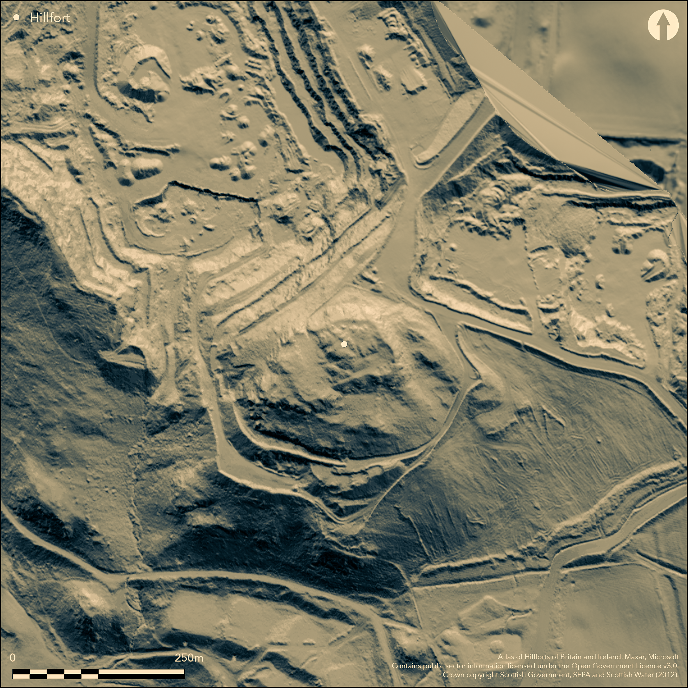
LiDAR 1m DTM Hillshade

Satellite Imagery
LiDAR 1m DTM Hillshade
Satellite Imagery
Scroll left/right to view further images.
HER: The West of Scotland Archaeology Service 7938 (None)
NMR: NS 47 SW 6 (43388)
SM: 2908
NGR: NS 4348 7440
X: 243480 Y: 674400 (OSGB36)
This fort is situated on the summit of Sheep Hill, a steep-sided spur above the N bank of the River Clyde that falls away steeply on all sides except the NE. The defences comprise three elements: a small oval enclosure occupying the rocky boss that forms the summit; an irregular enclosure taking in additional ground on the S and W; and an outer rampart enclosing a triangular terrace on the S. Excavations by Euan MacKie 1966-8 demonstrated that the enclosure on the summit, which measures no more than 40m from E to W by 27m transversely (0.08ha) internally, was the primary fortification, with a heavily vitrified timber-laced rampart. The rampart of the larger enclosure below it incorporated numerous pieces of vitrified stone and was evidently a seconday construction, enclosing an irregular area measuring about 82m from E to W by 45m transversely (0.38ha), to which the triangular annexe on the S is presumably appended. In its second phase, the fort had entrances on the N and S respectively, the former utilising a steep gully through the rock faces, and the latter across a gentler slope leading up from the annexe on the S, which has an entrance in its E side. Finds from deposits that had built up on a layer of rubble against the second phase rampart on the SE included a blue glass ring and fragments of finished and unfinished shale bracelets, as well as pieces of raw material (MacKie 1976, 212). At two points this rampart was found to also overlie earlier occupation deposits, a midden on the SE side of the fort yielding numerous sherds of pottery and eight fragments of moulds, including one for casting a Late Bronze Age axe (MacKie 1976, 212-13). Despite the vitrification of one of the sherds in the top of this midden, there is no reason to attribute a Late Bronze Age date to the small timber-laced fort on the summit.
Citizen Science: ✗
Reliability of Data: Confirmed
Reliability of Interpretation: Confirmed
X: -501762 Y: 7545913 (EPSG: 3857)
Longitude: -4.507403710926039 Latitude: 55.937142357956915 (EPSG:4326)
Country: Scotland
Current County or Unitary Authority: West Dunbartonshire
Historic County: Dunbartonshire
Current Parish/Community/Council/Townland: Old Kilpatrick
None
| Extant | ✓ |
| Cropmark | ✗ |
| Likely Destroyed | ✗ |
None
| Woodland | ✗ |
| Commercial Forestry Plantation | ✗ |
| Parkland | ✗ |
| Pasture (Grazing) | ✓ |
| Arable | ✗ |
| Scrub/Bracken | ✗ |
| Bare Outcrop | ✗ |
| Heather/Moorland | ✓ |
| Heath | ✗ |
| Built-up | ✗ |
| Coastal Grassland | ✗ |
| Other | ✗ |
None
| Contour Fort | ✓ |
| Partial Contour Fort | ✗ |
| Promontory Fort | ✗ |
| Hillslope Fort | ✗ |
| Level Terrain Fort | ✗ |
| Marsh Fort | ✗ |
| Multiple Enclosure Fort | ✓ |
| Hilltop | ✓ |
| Coastal Promontory | ✗ |
| Inland Promontory | ✗ |
| Valley Bottom | ✗ |
| Knoll/Hillock/Outcrop | ✗ |
| Ridge | ✗ |
| Cliff/Plateau-edge/Scarp | ✗ |
| Hillslope | ✗ |
| Lowland | ✗ |
| Spur | ✗ |
Dominant Topographic Feature: None
| North | ✗ |
| Northeast | ✗ |
| East | ✗ |
| Southeast | ✗ |
| South | ✗ |
| Southwest | ✗ |
| West | ✗ |
| Northwest | ✗ |
| Level | ✓ |
Altitude: 150.0m
N/A
No clear dating evidence for the sequence of fortifications
Reliability: C - Low
| Pre 1200BC | ✗ |
| 1200BC - 800BC | ✓ |
| 800BC - 400BC | ✗ |
| 400BC - AD50 | ✓ |
| AD50 - AD400 | ✗ |
| AD400 - AD 800 | ✗ |
| Post AD800 | ✗ |
| Unknown | ✗ |
| Pre Hillfort: | None |
| Post Hillfort: | None |
| Artefactual: | LBA moulds from under the second phase wall and a glass ring-bead from above. |
The first recognition of the fort on Sheep Hill comes with an excavation mounted by the Helensburgh Natural History and Antiquarian Society in 1893 (Bruce 1893, 319), and it appears shortly after on the 2nd edition OS 25-inch map (Dunbartonshire 1898, sheet 22.7). It was surveyed in 1955 by RCAHMS during the Survey of Marginal Lands, and resurveyed at 1:2500 in 1963. It was excavated by Euan MacKie 1966-9 (1976) and Scheduled in 1970. RCAHMS revisited in 1977
| Excavation (1893): | No record (Bruce 1893, 319) |
| 1st Identified Map Depiction (1896): | Annotated Fort on the 2nd edition OS 25-inch map (Dunbartonshire 1898, sheet 22.7) |
| Earthwork Survey (1955): | Plan and description during RCAHMS Survey of Marginal Lands (RCAHMS DBD 5/1-3; DP148470, DP148471 & SC1320522) |
| Other (1963): | Resurveyed at 1:2500 by the OS |
| Excavation (1966): | Euan MacKie (1966; 1976) |
| Excavation (1967): | Euan MacKie (1967; 1976) |
| Excavation (1968): | Euan MacKie (1968; 1976) |
| Excavation (1969): | Euan MacKie (1969; 1976) |
| Other (1970): | Scheduled |
| Other (1977): | Description by RCAHMS |
Featureless
None
| None | ✓ |
| Spring | ✗ |
| Stream | ✗ |
| Pool | ✗ |
| Flush | ✗ |
| Well | ✗ |
| Other | ✗ |
None
| No Known Features | ✓ |
| Round Stone Structures | ✗ |
| Rectangular Stone Structures | ✗ |
| Curvilinear Platforms | ✗ |
| Other Roundhouse Evidence | ✗ |
| Pits | ✗ |
| Quarry Hollows | ✗ |
| Other | ✗ |
Midden deposits
| No Known Excavation | ✗ |
| Pits | ✗ |
| Postholes | ✗ |
| Roundhouses | ✗ |
| Rectangular Structures | ✗ |
| Roads/Tracks | ✗ |
| Quarry Hollows | ✗ |
| Other | ✓ |
| Nothing Found | ✗ |
None
| No Known Geophysics | ✓ |
| Pits | ✗ |
| Roundhouses | ✗ |
| Rectangular Structures | ✗ |
| Roads/Tracks | ✗ |
| Quarry Hollows | ✗ |
| Other | ✗ |
| Nothing Found | ✗ |
Finds from deposits that had built up on a layer of rubble against the second phase rampart included a blue glass ring and fragments of finished and unfinished shale bracelets, as well as pieces of raw material, while in the midden below the rampart there were numerous sherds of pottery a eight fragments from bronze moulds, including the blade of an axe
| No Known Finds | ✗ |
| Pottery | ✓ |
| Metal | ✗ |
| Metalworking | ✓ |
| Human Bones | ✗ |
| Animal Bones | ✗ |
| Lithics | ✓ |
| Environmental | ✗ |
| Other | ✓ |
NO APPARENT FEATURES
| APs Not Checked | ✗ |
| None | ✓ |
| Roundhouses | ✗ |
| Rectangular Structures | ✗ |
| Pits | ✗ |
| Postholes | ✗ |
| Roads/Tracks | ✗ |
| Other | ✗ |
See main summary
| 2: | Circuit is fragmentary |
| 2: | None |
Guard Chambers: ✗
Chevaux de Frise: ✗
| 1. In-turned (North): | According to MacKie, to either side of the gully |
| 2. Simple Gap (South): | None |
Two successive ramparts, the inner little more than a dun on the summit
| Area 1: | 0.38ha. |
| Total: | 0.38ha. |
Total Footprint Area: 0.6ha.
None
| ✓ | Second phase given as the fort measurements |
| ✓ | The second phase fort is detailed here |
| NE Quadrant: | 1 |
| SE Quadrant: | 1 |
| SW Quadrant: | 1 |
| NW Quadrant: | 1 |
| Total: | 1 |
| Partial Univallate | ✗ |
| Univallate | ✓ |
| Partial Bivallate | ✗ |
| Bivallate | ✗ |
| Partial Multivallate | ✗ |
| Multivallate | ✗ |
| Unknown | ✗ |
| Partial Univallate | ✗ |
| Univallate | ✓ |
| Partial Bivallate | ✗ |
| Bivallate | ✗ |
| Partial Multivallate | ✗ |
| Multivallate | ✗ |
Vitrifaction belongs to the earlier and smaller fortification on the summit
| None | ✗ |
| Earthen Bank | ✗ |
| Stone Wall | ✓ |
| Rubble | ✗ |
| Wall-walk | ✗ |
| Evidence of Timber | ✗ |
| Vitrification | ✓ |
| Other Burning | ✗ |
| Palisade | ✗ |
| Counter Scarp Bank | ✗ |
| Berm | ✗ |
| Unfinished | ✗ |
| Other | ✗ |
None
| None | ✗ |
| Earthen Bank | ✗ |
| Stone Wall | ✓ |
| Murus Duplex | ✗ |
| Timber-framed | ✗ |
| Timber-laced | ✗ |
| Vitrification | ✓ |
| Other Burning | ✗ |
| Palisade | ✗ |
| Counter Scarp Bank | ✗ |
| Berm | ✗ |
| Unfinished | ✗ |
| No Known Excavation | ✗ |
| Other | ✗ |
| ✗ | None |
| ✗ | None |
Number of Ditches: None
| ✓ | There is a small triangular annexe (0.13ha) on the south, through which access to the fort from this side passes. |
Bruce, J (1893) The history of the parish of West or Old Kilpatrick and of the church and certain lands in the parish of East or New Kilpatrick. Glasgow
Feachem, R W (1963) Guide to Prehistoric Scotland. Batsford: London (p 118-19)
MacKie, E 1966 'Sheep hill vitrified fort'. Disc Exc Scot 1966, 24-5
MacKie, E 1967 'Sheep hill vitrified fort'. Disc Exc Scot 1967, 25
MacKie, E 1968 'Sheep hill vitrified fort'. Disc Exc Scot 1968, 20
MacKie, E 1969 'Sheep hill vitrified fort'. Disc Exc Scot 1969, 22
MacKie, E W (1976) 'The vitrified forts of Scotland', in Harding, D W (ed) Hillforts: later prehistoric earthworks in Britain and Ireland. Academic Press: London, New York & San Francisco, 205-35
Atlas of Hillforts:
Wikidata:
This work is licensed under CC BY-SA 4.0![]()
![]()
![]() and should be cited as:
and should be cited as:
Lock, Gary and Ralston, Ian. 2024. Atlas of Hillforts of Britain and Ireland. Available at: https://hillforts.arch.ox.ac.uk
Document Version 1.1