LiDAR 1m DTM Hillshade
Satellite Imagery
LiDAR 1m DTM Hillshade
Satellite Imagery
Scroll left/right to view further images.
HER: The West of Scotland Archaeology Service 8264 (None)
NMR: NS 54 NW 1 (43771)
SM: 12882
NGR: NS 5468 4895
X: 254684 Y: 648955 (OSGB36)
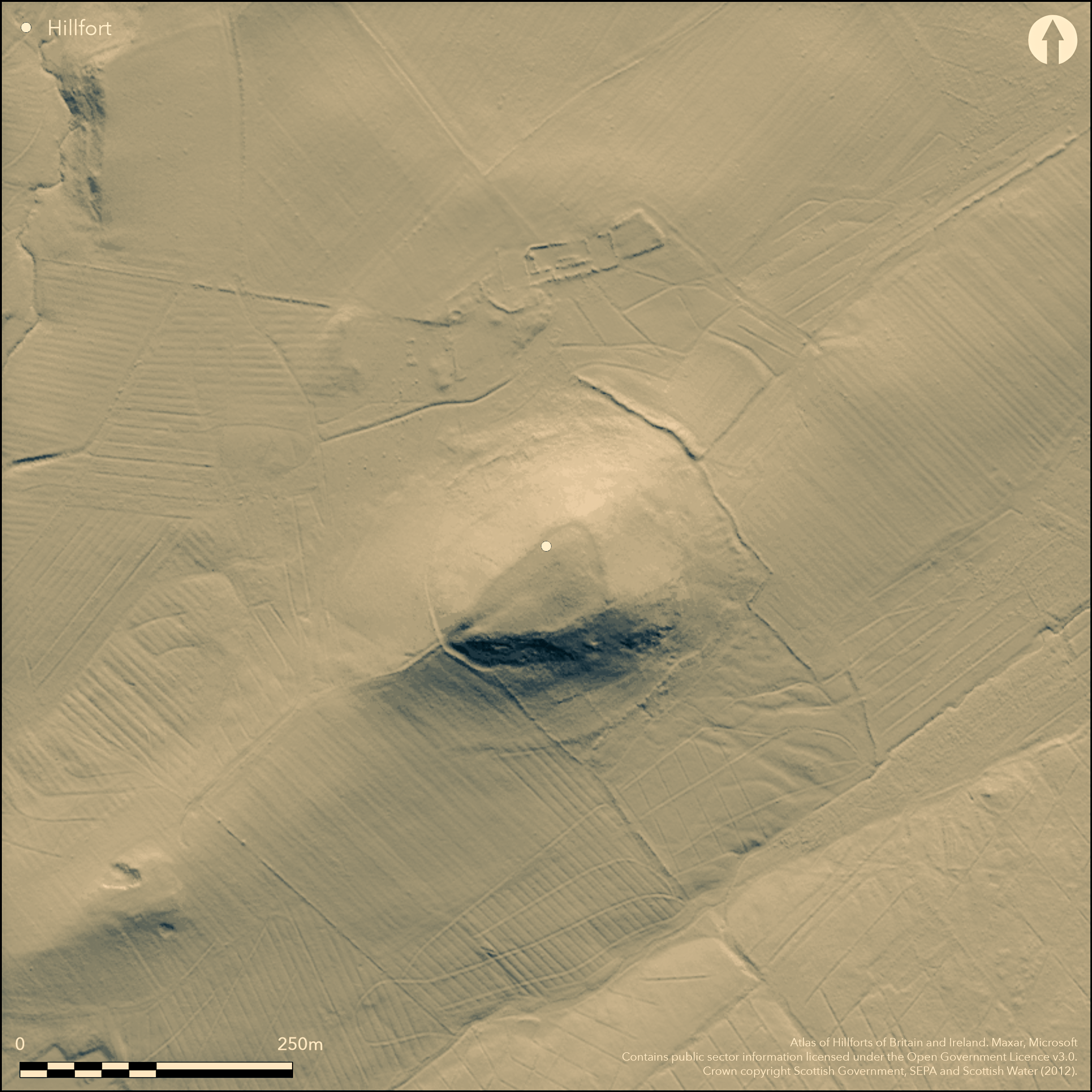
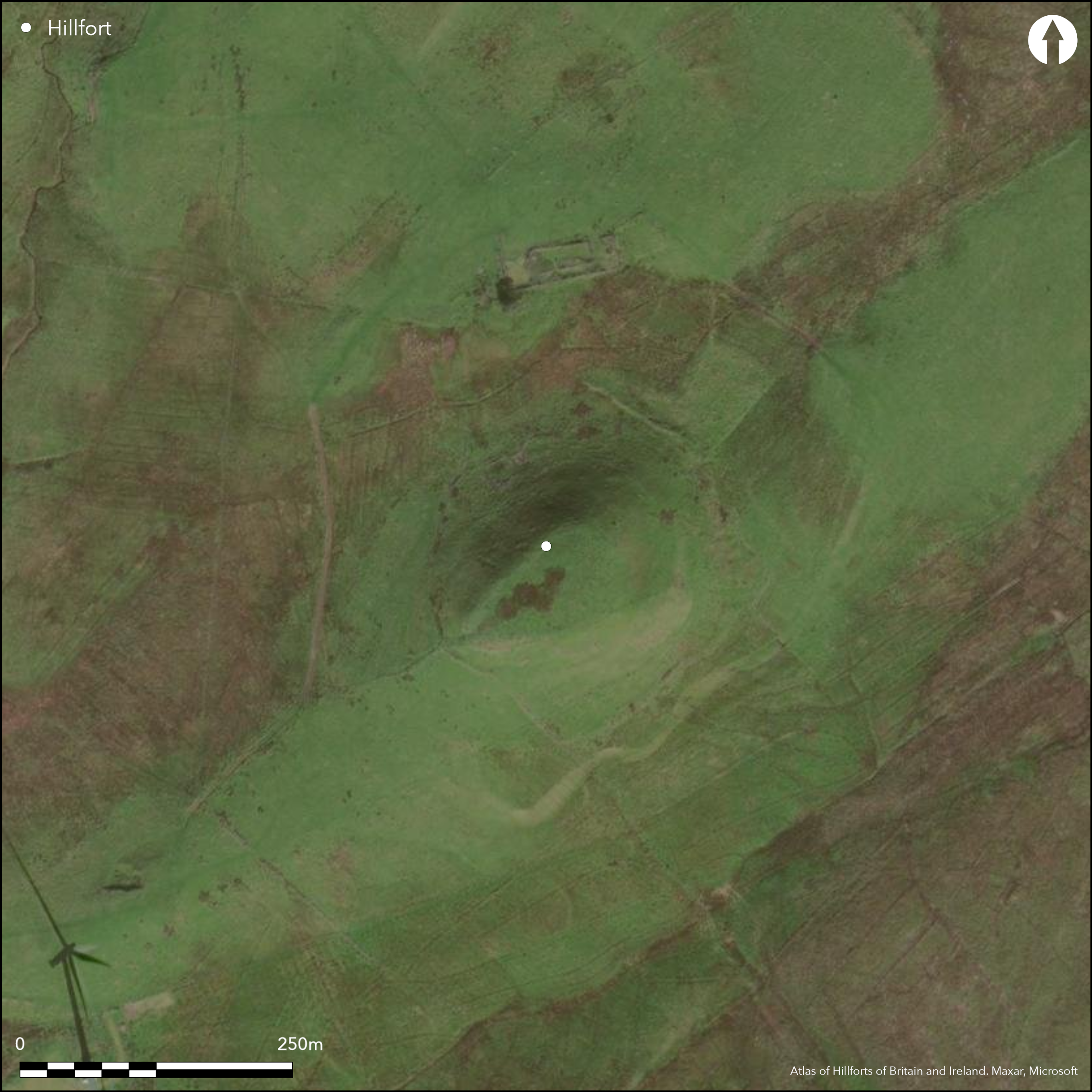
This fort comprises an inner and outer enclosure, the former taking in the summit of Dunwan Hill, and the latter a much larger area extending down the slope. Roughly triangular on plan, the interior of the inner enclosure measures about 74m from NE to SW by a maximum of 45m transversely (0.27ha), its extent defined by the lip of the summit area, but with evidence of a substantial stone rampart up to on the E and S flanks, now largely reduced to little more than a line of outer facing stones some 3.5m below the lip. A well-defined entrance can be seen at the apex of the SW end, with a hollowed track dropping down the slope below, while within the interior there are traces of two timber round-houses, each defined by a shallow groove about 0.6m in breadth. On the SW, where the outer rampart is overlain by a later stone dyke, the outer defences comprise a low stony bank with an internal ditch some 3m broad, but elsewhere little more than a scarp or terrace can be traced round the foot of the hill, enclosing an oval area measuring about 130m from NE to SW by 90m transversely (0.94ha); terminals to the ditch to either side of the bottom of the hollowed trackway dropping down from the inner entrance suggest that there was also an entrance in the outer defences on the SW. While the OS in 1955 suggested that this outer enclosure was possibly associated with later farming enclosures around the hill, as Richard Feachem observed, it appears a convincing if unusual enclosure on aerial photographs, and he also speculated that there was perhaps yet another rampart amongst the field banks about 20m beyond it.
Citizen Science: ✓
Reliability of Data: Confirmed
Reliability of Interpretation: Confirmed
X: -480298 Y: 7501339 (EPSG: 3857)
Longitude: -4.314592961909418 Latitude: 55.71222196376207 (EPSG:4326)
Country: Scotland
Current County or Unitary Authority: East Renfrewshire
Historic County: Renfrewshire
Current Parish/Community/Council/Townland: Eaglesham
None
| Extant | ✓ |
| Cropmark | ✗ |
| Likely Destroyed | ✗ |
None
| Woodland | ✗ |
| Commercial Forestry Plantation | ✗ |
| Parkland | ✗ |
| Pasture (Grazing) | ✓ |
| Arable | ✗ |
| Scrub/Bracken | ✗ |
| Bare Outcrop | ✗ |
| Heather/Moorland | ✓ |
| Heath | ✗ |
| Built-up | ✗ |
| Coastal Grassland | ✗ |
| Other | ✗ |
None
| Contour Fort | ✓ |
| Partial Contour Fort | ✗ |
| Promontory Fort | ✗ |
| Hillslope Fort | ✗ |
| Level Terrain Fort | ✗ |
| Marsh Fort | ✗ |
| Multiple Enclosure Fort | ✓ |
| Hilltop | ✓ |
| Coastal Promontory | ✗ |
| Inland Promontory | ✗ |
| Valley Bottom | ✗ |
| Knoll/Hillock/Outcrop | ✗ |
| Ridge | ✗ |
| Cliff/Plateau-edge/Scarp | ✗ |
| Hillslope | ✗ |
| Lowland | ✗ |
| Spur | ✗ |
Dominant Topographic Feature: None
| North | ✗ |
| Northeast | ✗ |
| East | ✗ |
| Southeast | ✗ |
| South | ✗ |
| Southwest | ✗ |
| West | ✗ |
| Northwest | ✗ |
| Level | ✓ |
Altitude: 295.0m
N/A
In the absence of excavation, there are neither stratified artefacts nor radiocarbon dates to provide a chronology for the defences.
Reliability: D - None
| Pre 1200BC | ✗ |
| 1200BC - 800BC | ✗ |
| 800BC - 400BC | ✗ |
| 400BC - AD50 | ✗ |
| AD50 - AD400 | ✗ |
| AD400 - AD 800 | ✗ |
| Post AD800 | ✗ |
| Unknown | ✓ |
| Pre Hillfort: | None |
| Post Hillfort: | Overlain by post-medieval field banks |
First identified and surveyed in 1954 by the RCAHMS Survey of Marginal Lands (Feachem 1963, 148), it was visited the following year by the OS and surveyed at 1:2500 in 1966. It was photographed from the air by John Dewar in 1971, and more recently in 2005 surveyed by ACFA (Hunter and Hunter 2005). It was Scheduled in 2011. In 2013 John Lumley prepared a record of the fort on behalf of the Hillfort Atlas Project.
| Earthwork Survey (1954): | Plan and description during RCAHMS Survey of Marginal Lands (Feachem 1963, 148; RCAHMS DC31550 & DP149888 |
| 1st Identified Map Depiction (1966): | Surveyed at 1:2500 by the OS |
| Earthwork Survey (2005): | (Hunter and Hunter 2005; RCAHMS MS 2611) |
| Other (2011): | Scheduled |
| Other (2013): | John Lumley for the Hillfort Atlas Project |
Two round-houses occur within the inner enclosure; the outer enclosure is featureless.
None
| None | ✓ |
| Spring | ✗ |
| Stream | ✗ |
| Pool | ✗ |
| Flush | ✗ |
| Well | ✗ |
| Other | ✗ |
Ring-grooves
| No Known Features | ✗ |
| Round Stone Structures | ✗ |
| Rectangular Stone Structures | ✗ |
| Curvilinear Platforms | ✗ |
| Other Roundhouse Evidence | ✓ |
| Pits | ✗ |
| Quarry Hollows | ✗ |
| Other | ✗ |
None
| No Known Excavation | ✓ |
| Pits | ✗ |
| Postholes | ✗ |
| Roundhouses | ✗ |
| Rectangular Structures | ✗ |
| Roads/Tracks | ✗ |
| Quarry Hollows | ✗ |
| Other | ✗ |
| Nothing Found | ✗ |
None
| No Known Geophysics | ✓ |
| Pits | ✗ |
| Roundhouses | ✗ |
| Rectangular Structures | ✗ |
| Roads/Tracks | ✗ |
| Quarry Hollows | ✗ |
| Other | ✗ |
| Nothing Found | ✗ |
None
| No Known Finds | ✓ |
| Pottery | ✗ |
| Metal | ✗ |
| Metalworking | ✗ |
| Human Bones | ✗ |
| Animal Bones | ✗ |
| Lithics | ✗ |
| Environmental | ✗ |
| Other | ✗ |
None
| APs Not Checked | ✗ |
| None | ✗ |
| Roundhouses | ✓ |
| Rectangular Structures | ✗ |
| Pits | ✗ |
| Postholes | ✗ |
| Roads/Tracks | ✗ |
| Other | ✗ |
See main summary
| 1: | Large parts of the circuit are barely visible |
| 2: | None |
Guard Chambers: ✗
Chevaux de Frise: ✗
| 1. Simple Gap (South west): | Terminals to the ditches of the outer defence either side of the hollowed trackway on the SW |
Two ramparts, though possibly representing two separate schemes of defence.
| Area 1: | 0.27ha. |
| Area 2: | 0.94ha. |
| Total: | 0.94ha. |
Total Footprint Area: 1.0ha.
None
| ✗ | None |
| ✓ | The two ramparts may represent separate schemes of defence, while Feachem speculates there may be a third, outer line |
| NE Quadrant: | 2 |
| SE Quadrant: | 2 |
| SW Quadrant: | 2 |
| NW Quadrant: | 2 |
| Total: | 2 |
| Partial Univallate | ✗ |
| Univallate | ✗ |
| Partial Bivallate | ✗ |
| Bivallate | ✓ |
| Partial Multivallate | ✗ |
| Multivallate | ✗ |
| Unknown | ✗ |
| Partial Univallate | ✗ |
| Univallate | ✓ |
| Partial Bivallate | ✗ |
| Bivallate | ✗ |
| Partial Multivallate | ✗ |
| Multivallate | ✗ |
None
| None | ✗ |
| Earthen Bank | ✓ |
| Stone Wall | ✓ |
| Rubble | ✗ |
| Wall-walk | ✗ |
| Evidence of Timber | ✗ |
| Vitrification | ✗ |
| Other Burning | ✗ |
| Palisade | ✗ |
| Counter Scarp Bank | ✗ |
| Berm | ✗ |
| Unfinished | ✗ |
| Other | ✗ |
None
| None | ✗ |
| Earthen Bank | ✗ |
| Stone Wall | ✗ |
| Murus Duplex | ✗ |
| Timber-framed | ✗ |
| Timber-laced | ✗ |
| Vitrification | ✗ |
| Other Burning | ✗ |
| Palisade | ✗ |
| Counter Scarp Bank | ✗ |
| Berm | ✗ |
| Unfinished | ✗ |
| No Known Excavation | ✓ |
| Other | ✗ |
| ✗ | None |
| ✓ | Outer enclosure has internal ditch on the SW |
Number of Ditches: 1
| ✓ | The outer rampart encloses an area of 0.94ha, but there is no evidence that this enclosure is dependent on the inner rampart and it may represent a separate scheme of defence. |
Feachem, R (1963) A guide to prehistoric Scotland. Batsford: London
Hunter and Hunter, R and S (2005) 'Farm survey (Eaglesham parish), survey' Disc Exc Scot 6 (2005), 58
Atlas of Hillforts:
Wikidata:
This work is licensed under CC BY-SA 4.0![]()
![]()
![]() and should be cited as:
and should be cited as:
Lock, Gary and Ralston, Ian. 2024. Atlas of Hillforts of Britain and Ireland. Available at: https://hillforts.arch.ox.ac.uk
Document Version 1.1