
LiDAR 1m DTM Hillshade
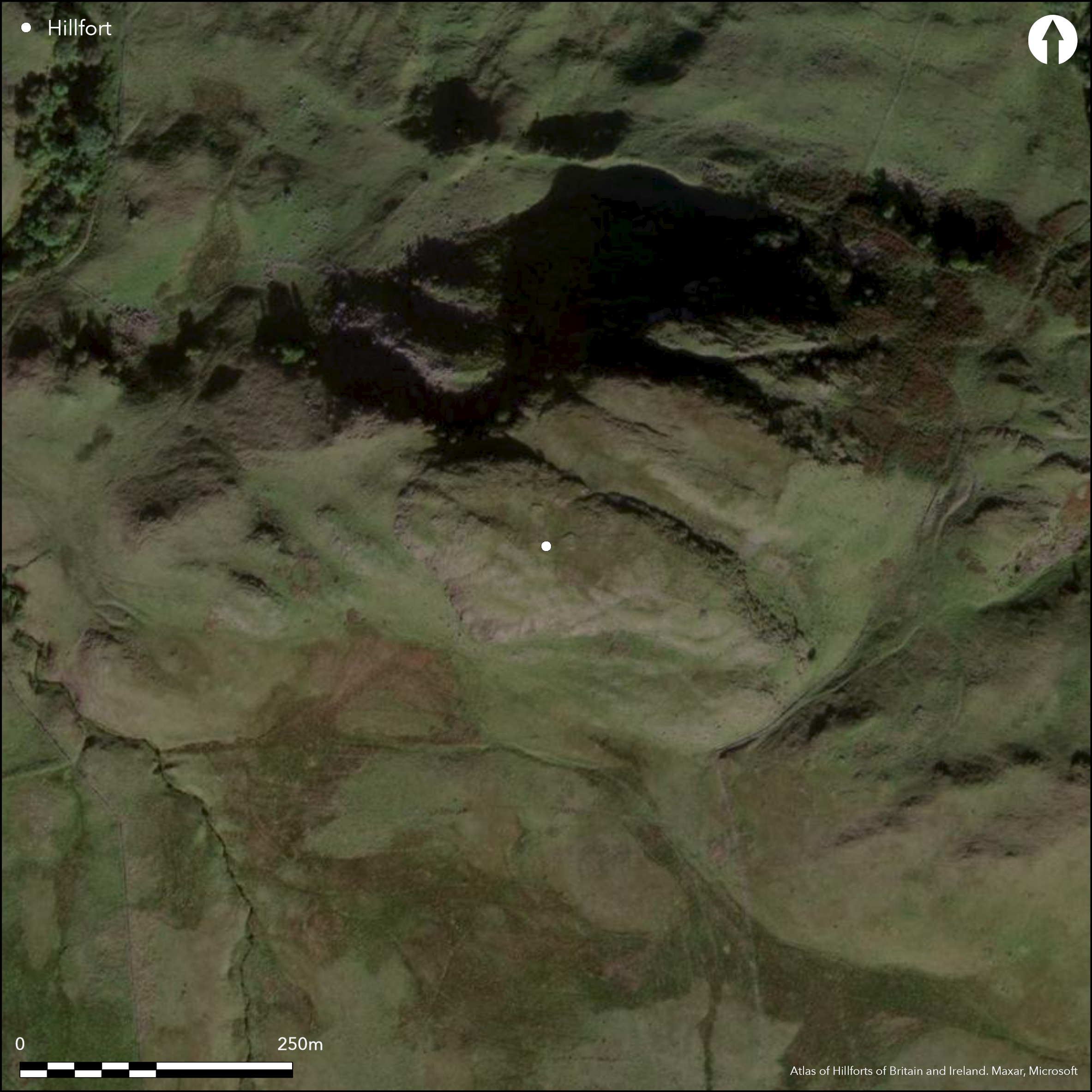
Satellite Imagery
LiDAR 1m DTM Hillshade
Satellite Imagery
Scroll left/right to view further images.
HER: Stirling 617 (None)
NMR: NS 68 NW 10 (45294)
SM: 2575
NGR: NS 6050 8647
X: 260500 Y: 686470 (OSGB36)
This fort occupies the rock-girt summit of Dunmore, the hill overlooking Fintry from the WSW. Oblong on plan, it measures about 158m from ESE to WNW by 45m transversely (0.55ha) within a ruined wall about 3.5m in thickness, though this disappears along the SW margin of the summit and elsewhere is largely reduced to a band of rubble with a few outer facing-stones visible a little below the crest of the rocky slope. An outer rampart can be seen on the SE, detaching itself from the main wall and following a natural crest about 3m lower down the slope, and there is a further outwork crossing the gully at the foot of the summit ridge on the E and extending along the E face of a lower terrace, combining with the topography of the outcrops elsewhere to form an annexe measuring about 130m from ESE to WNW by 65m transversely (0.8ha). The main entrance to the fort is on the N, where a gully drops down into the annexe, and there is also a narrow gap in the annexe wall in the bottom of the gully on the ESE. What may be a second entrance on the S descends via a narrow crevice to a lower terrace flanking this side of the fort, extending along which there are traces of a narrow wall of unknown date or purpose; at one point this wall is overlain by the stone footing of a rectangular building.
Citizen Science: ✓
Reliability of Data: Confirmed
Reliability of Interpretation: Confirmed
X: -472154 Y: 7568525 (EPSG: 3857)
Longitude: -4.241431381291686 Latitude: 56.050748717824035 (EPSG:4326)
Country: Scotland
Current County or Unitary Authority: Stirling
Historic County: Stirlingshire
Current Parish/Community/Council/Townland: Fintry
None
| Extant | ✓ |
| Cropmark | ✗ |
| Likely Destroyed | ✗ |
None
| Woodland | ✗ |
| Commercial Forestry Plantation | ✗ |
| Parkland | ✗ |
| Pasture (Grazing) | ✓ |
| Arable | ✗ |
| Scrub/Bracken | ✗ |
| Bare Outcrop | ✗ |
| Heather/Moorland | ✓ |
| Heath | ✗ |
| Built-up | ✗ |
| Coastal Grassland | ✗ |
| Other | ✗ |
None
| Contour Fort | ✓ |
| Partial Contour Fort | ✗ |
| Promontory Fort | ✗ |
| Hillslope Fort | ✗ |
| Level Terrain Fort | ✗ |
| Marsh Fort | ✗ |
| Multiple Enclosure Fort | ✓ |
| Hilltop | ✓ |
| Coastal Promontory | ✗ |
| Inland Promontory | ✗ |
| Valley Bottom | ✗ |
| Knoll/Hillock/Outcrop | ✗ |
| Ridge | ✗ |
| Cliff/Plateau-edge/Scarp | ✗ |
| Hillslope | ✗ |
| Lowland | ✗ |
| Spur | ✗ |
Dominant Topographic Feature: None
| North | ✗ |
| Northeast | ✗ |
| East | ✗ |
| Southeast | ✗ |
| South | ✗ |
| Southwest | ✗ |
| West | ✗ |
| Northwest | ✗ |
| Level | ✓ |
Altitude: 340.0m
N/A
In the absence of excavation, there are neither stratified artefacts nor radiocarbon dates to provide a chronology for the defences.
Reliability: D - None
| Pre 1200BC | ✗ |
| 1200BC - 800BC | ✗ |
| 800BC - 400BC | ✗ |
| 400BC - AD50 | ✗ |
| AD50 - AD400 | ✗ |
| AD400 - AD 800 | ✗ |
| Post AD800 | ✗ |
| Unknown | ✓ |
| Pre Hillfort: | None |
| Post Hillfort: | Rectangular hut overlying minor wall on the S, and a marker cairn |
Identified by RCAHMS in 1953 during the Survey of Marginal Lands and carried over into the preparation of the County Inventory for Stirlingshire (RCAHMS 1963, 76-8, no.77, fig 16), it was visited by the OS in 1957 and 1975, and revisited by RCAHMS in 1978. It was Scheduled in 1966.
| Earthwork Survey (1953): | Plan and description during RCAHMS Survey of Marginal Lands (RCAHMS 1963, 76-8, no.77, fig 16; RCAHMS STD 22/1-4; DP023971) |
| Other (1957): | Visited by the OS |
| Other (1966): | Scheduled |
| 1st Identified Map Depiction (1975): | 1:10,000 map |
| Other (1975): | Surveyed at 1:10.000 by the OS |
| Other (1978): | Description by RCAHMS |
Featureless apart from the marker cairn at the ESE end
None
| None | ✓ |
| Spring | ✗ |
| Stream | ✗ |
| Pool | ✗ |
| Flush | ✗ |
| Well | ✗ |
| Other | ✗ |
None
| No Known Features | ✓ |
| Round Stone Structures | ✗ |
| Rectangular Stone Structures | ✗ |
| Curvilinear Platforms | ✗ |
| Other Roundhouse Evidence | ✗ |
| Pits | ✗ |
| Quarry Hollows | ✗ |
| Other | ✗ |
None
| No Known Excavation | ✓ |
| Pits | ✗ |
| Postholes | ✗ |
| Roundhouses | ✗ |
| Rectangular Structures | ✗ |
| Roads/Tracks | ✗ |
| Quarry Hollows | ✗ |
| Other | ✗ |
| Nothing Found | ✗ |
None
| No Known Geophysics | ✓ |
| Pits | ✗ |
| Roundhouses | ✗ |
| Rectangular Structures | ✗ |
| Roads/Tracks | ✗ |
| Quarry Hollows | ✗ |
| Other | ✗ |
| Nothing Found | ✗ |
None
| No Known Finds | ✓ |
| Pottery | ✗ |
| Metal | ✗ |
| Metalworking | ✗ |
| Human Bones | ✗ |
| Animal Bones | ✗ |
| Lithics | ✗ |
| Environmental | ✗ |
| Other | ✗ |
NO APPARENT FEATURES
| APs Not Checked | ✗ |
| None | ✓ |
| Roundhouses | ✗ |
| Rectangular Structures | ✗ |
| Pits | ✗ |
| Postholes | ✗ |
| Roads/Tracks | ✗ |
| Other | ✗ |
See main summary
| 2: | None |
| 2: | None |
Guard Chambers: ✗
Chevaux de Frise: ✗
| 1. Simple Gap (North): | None |
| 2. Simple Gap (South): | None |
Single rampart
| Area 1: | 0.55ha. |
| Area 2: | 1.35ha. |
| Total: | 1.35ha. |
Total Footprint Area: 1.6ha.
None
| ✗ | Annex not necessarily different in date |
| ✗ | None |
| NE Quadrant: | 1 |
| SE Quadrant: | 2 |
| SW Quadrant: | 0 |
| NW Quadrant: | 1 |
| Total: | 2 |
| Partial Univallate | ✓ |
| Univallate | ✗ |
| Partial Bivallate | ✓ |
| Bivallate | ✗ |
| Partial Multivallate | ✗ |
| Multivallate | ✗ |
| Unknown | ✗ |
| Partial Univallate | ✓ |
| Univallate | ✗ |
| Partial Bivallate | ✗ |
| Bivallate | ✗ |
| Partial Multivallate | ✗ |
| Multivallate | ✗ |
None
| None | ✗ |
| Earthen Bank | ✗ |
| Stone Wall | ✓ |
| Rubble | ✗ |
| Wall-walk | ✗ |
| Evidence of Timber | ✗ |
| Vitrification | ✗ |
| Other Burning | ✗ |
| Palisade | ✗ |
| Counter Scarp Bank | ✗ |
| Berm | ✗ |
| Unfinished | ✗ |
| Other | ✗ |
None
| None | ✗ |
| Earthen Bank | ✗ |
| Stone Wall | ✗ |
| Murus Duplex | ✗ |
| Timber-framed | ✗ |
| Timber-laced | ✗ |
| Vitrification | ✗ |
| Other Burning | ✗ |
| Palisade | ✗ |
| Counter Scarp Bank | ✗ |
| Berm | ✗ |
| Unfinished | ✗ |
| No Known Excavation | ✓ |
| Other | ✗ |
| ✗ | None |
| ✗ | None |
Number of Ditches: None
| ✓ | A length of wall fronting the E flank of a rocky terrace below the N flank of the fort, controls access to this area and thus forms an annexe below the fort, measuring about 130m from ESE to WNW by 65m transversely (0.8ha). The main entrance to the fort opens into this annexe, and there is probably a gap in its wall in the bottom of a natural gully on the E. |
RCAHMS (1963) The Royal Commission on the Ancient and Historical Monuments of Scotland. Stirlingshire: an inventory of the ancient monuments, 2v. HMSO: Edinburgh
Atlas of Hillforts:
Wikidata:
This work is licensed under CC BY-SA 4.0![]()
![]()
![]() and should be cited as:
and should be cited as:
Lock, Gary and Ralston, Ian. 2024. Atlas of Hillforts of Britain and Ireland. Available at: https://hillforts.arch.ox.ac.uk
Document Version 1.1