Satellite Imagery
Satellite Imagery
HER: Stirling 1221.01 (None)
NMR: NS 89 NW 14 (47117)
SM: 2182
NGR: NS 8324 9736
X: 283240 Y: 697360 (OSGB36)
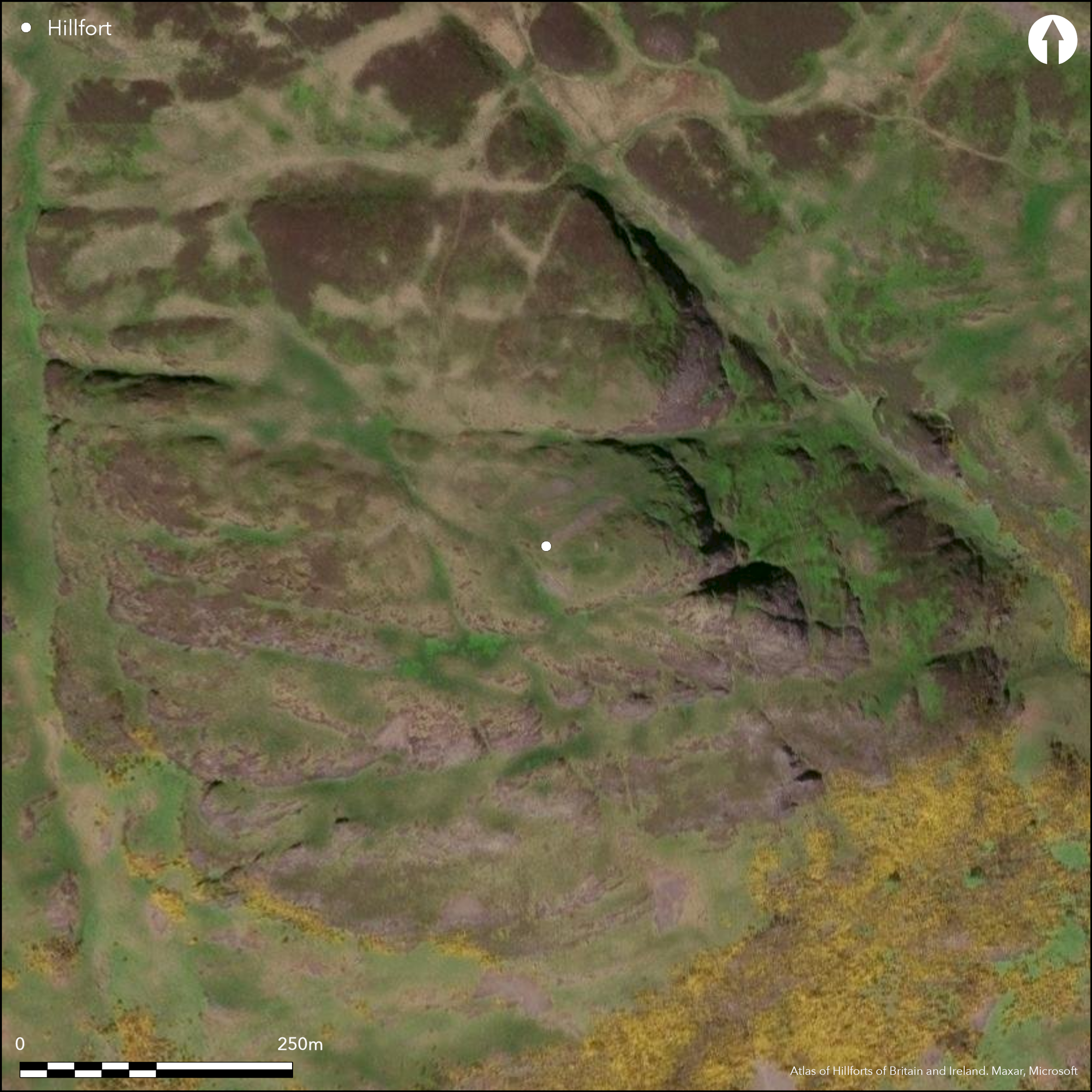
This fort is situated on a subsidiary spur to the SW of the summit of Dumyat, utilising the topography to create what is in effect a promontory fort defended on the NE, SE and SW by cliffs and steep slopes falling away from its crest at 335m OD down virtually to sea level. The defences comprise two main elements: an oval enclosure on the summit; and two ramparts cutting off the only accessible line of approach from the W. The inner enclosure measures 27m from E to W by 16m transversely (0.03ha) within a band of rubble spread some 4.5m in thickness. The outer defences enclose a much bigger area measuring about 95m from E to W by 50m transversely (0.4ha); spread up to 5.5m in thickness, they return and unite to either side of the entrance on the W. The date and purpose of several other walls reduced to rickles of stones within the interior, and forming external enclosures to either side of the entrance, are unknown. In 1952 RCAHMS investigators found several pieces of vitrified stone in the inner of the two outer ramparts, but in 1978 only a single piece was located, and this came from the wall of the inner enclosure. While the chronological relationship between these two elements is not known, it is likely that the inner enclosure has been inserted into the interior of an earlier fort. This is one of two forts (see Atlas No.1492) that stand on hills bearing a placename derived from the ancient tribal grouping of the Maeatae (Watson 1926, 59, 100).
Citizen Science: ✗
Reliability of Data: Confirmed
Reliability of Interpretation: Confirmed
X: -432066 Y: 7589260 (EPSG: 3857)
Longitude: -3.881317007660158 Latitude: 56.15462913905709 (EPSG:4326)
Country: Scotland
Current County or Unitary Authority: Stirling
Historic County: Stirlingshire
Current Parish/Community/Council/Townland: Logie
None
| Extant | ✓ |
| Cropmark | ✗ |
| Likely Destroyed | ✗ |
None
| Woodland | ✗ |
| Commercial Forestry Plantation | ✗ |
| Parkland | ✗ |
| Pasture (Grazing) | ✓ |
| Arable | ✗ |
| Scrub/Bracken | ✗ |
| Bare Outcrop | ✗ |
| Heather/Moorland | ✓ |
| Heath | ✗ |
| Built-up | ✗ |
| Coastal Grassland | ✗ |
| Other | ✗ |
None
| Contour Fort | ✗ |
| Partial Contour Fort | ✗ |
| Promontory Fort | ✓ |
| Hillslope Fort | ✗ |
| Level Terrain Fort | ✗ |
| Marsh Fort | ✗ |
| Multiple Enclosure Fort | ✗ |
| Hilltop | ✓ |
| Coastal Promontory | ✗ |
| Inland Promontory | ✓ |
| Valley Bottom | ✗ |
| Knoll/Hillock/Outcrop | ✗ |
| Ridge | ✗ |
| Cliff/Plateau-edge/Scarp | ✗ |
| Hillslope | ✗ |
| Lowland | ✗ |
| Spur | ✓ |
Dominant Topographic Feature: None
| North | ✗ |
| Northeast | ✗ |
| East | ✗ |
| Southeast | ✗ |
| South | ✗ |
| Southwest | ✗ |
| West | ✗ |
| Northwest | ✗ |
| Level | ✓ |
Altitude: 374.0m
N/A
In the absence of excavation, there are neither stratified artefacts nor radiocarbon dates to provide a chronology for the defences.
Reliability: D - None
| Pre 1200BC | ✗ |
| 1200BC - 800BC | ✗ |
| 800BC - 400BC | ✗ |
| 400BC - AD50 | ✗ |
| AD50 - AD400 | ✗ |
| AD400 - AD 800 | ✗ |
| Post AD800 | ✗ |
| Unknown | ✓ |
| Pre Hillfort: | None |
| Post Hillfort: | Probably the insertion of the dun |
Despite the spur being named Castle Law, this fort does not appear on the early editions of the OS maps and apparently escapes notice until the RCAHMS Survey of Marginal Lands (Feachem 1955, 77; 1963, 157), prior to its inclusion in the County Inventory for Stirlingshire (RCAHMS 1963, 69-71, no.68, fig 7). W J Watson, however, correlated its placename with the ancient tribal grouping of the Maeatae (Watson 1926, 59). It was visited by the OS in 1974 and revisited by RCAHMS in 1978. It was Scheduled in 1996. Murray Cook is planning to carry out an evaluation and survey here.
| Earthwork Survey (1952): | Plan and description during RCAHMS Survey of Marginal Lands (RCAHMS 1963, 69-71, no.68, fig 7; RCAHMS STD 19/1-3) |
| Other (1974): | Surveyed at 1:10.000 by the OS |
| Other (1978): | Description by RCAHMS |
| Other (1996): | Scheduled |
Dun stands on the highest point of the interior
None
| None | ✓ |
| Spring | ✗ |
| Stream | ✗ |
| Pool | ✗ |
| Flush | ✗ |
| Well | ✗ |
| Other | ✗ |
Dun
| No Known Features | ✗ |
| Round Stone Structures | ✗ |
| Rectangular Stone Structures | ✗ |
| Curvilinear Platforms | ✗ |
| Other Roundhouse Evidence | ✗ |
| Pits | ✗ |
| Quarry Hollows | ✗ |
| Other | ✓ |
None
| No Known Excavation | ✓ |
| Pits | ✗ |
| Postholes | ✗ |
| Roundhouses | ✗ |
| Rectangular Structures | ✗ |
| Roads/Tracks | ✗ |
| Quarry Hollows | ✗ |
| Other | ✗ |
| Nothing Found | ✗ |
None
| No Known Geophysics | ✓ |
| Pits | ✗ |
| Roundhouses | ✗ |
| Rectangular Structures | ✗ |
| Roads/Tracks | ✗ |
| Quarry Hollows | ✗ |
| Other | ✗ |
| Nothing Found | ✗ |
None
| No Known Finds | ✓ |
| Pottery | ✗ |
| Metal | ✗ |
| Metalworking | ✗ |
| Human Bones | ✗ |
| Animal Bones | ✗ |
| Lithics | ✗ |
| Environmental | ✗ |
| Other | ✗ |
NO APPARENT FEATURES
| APs Not Checked | ✗ |
| None | ✓ |
| Roundhouses | ✗ |
| Rectangular Structures | ✗ |
| Pits | ✗ |
| Postholes | ✗ |
| Roads/Tracks | ✗ |
| Other | ✗ |
See main summary
| 1: | None |
| 2: | None |
Guard Chambers: ✗
Chevaux de Frise: ✗
| 1. Passage-way/Corridor (West): | None |
The two ramparts cutting off the summit of a spur are assumed here to be the defences of the fort
| Area 1: | 0.4ha. |
| Total: | 0.4ha. |
Total Footprint Area: 0.57ha.
None
| ✗ | None |
| ✗ | None |
| NE Quadrant: | 0 |
| SE Quadrant: | 0 |
| SW Quadrant: | 2 |
| NW Quadrant: | 2 |
| Total: | 2 |
| Partial Univallate | ✗ |
| Univallate | ✗ |
| Partial Bivallate | ✓ |
| Bivallate | ✗ |
| Partial Multivallate | ✗ |
| Multivallate | ✗ |
| Unknown | ✗ |
| Partial Univallate | ✗ |
| Univallate | ✗ |
| Partial Bivallate | ✗ |
| Bivallate | ✗ |
| Partial Multivallate | ✗ |
| Multivallate | ✗ |
None
| None | ✗ |
| Earthen Bank | ✗ |
| Stone Wall | ✓ |
| Rubble | ✗ |
| Wall-walk | ✗ |
| Evidence of Timber | ✗ |
| Vitrification | ✓ |
| Other Burning | ✗ |
| Palisade | ✗ |
| Counter Scarp Bank | ✗ |
| Berm | ✗ |
| Unfinished | ✗ |
| Other | ✗ |
None
| None | ✗ |
| Earthen Bank | ✗ |
| Stone Wall | ✗ |
| Murus Duplex | ✗ |
| Timber-framed | ✗ |
| Timber-laced | ✗ |
| Vitrification | ✗ |
| Other Burning | ✗ |
| Palisade | ✗ |
| Counter Scarp Bank | ✗ |
| Berm | ✗ |
| Unfinished | ✗ |
| No Known Excavation | ✓ |
| Other | ✗ |
| ✗ | None |
| ✗ | None |
Number of Ditches: None
| ✗ | None |
Feachem, R W (1955) 'Fortifications', in Wainwright, F T (ed) The Problem of the Picts. Edinburgh
Feachem, R W (1963) Guide to Prehistoric Scotland. Batsford: Edinburgh
RCAHMS (1963) The Royal Commission on the Ancient and Historical Monuments of Scotland. Stirlingshire: an inventory of the ancient monuments, 2v Edinburgh
Watson, W J (1926) The history of the Celtic place-names of Scotland: being the Rhind lectures on archaeology (expanded) delivered in 1916. Edinburgh
Atlas of Hillforts:
Wikidata:
This work is licensed under CC BY-SA 4.0![]()
![]()
![]() and should be cited as:
and should be cited as:
Lock, Gary and Ralston, Ian. 2024. Atlas of Hillforts of Britain and Ireland. Available at: https://hillforts.arch.ox.ac.uk
Document Version 1.1