Satellite Imagery
Satellite Imagery
HER: The West of Scotland Archaeology Service 10512 (None)
NMR: NS 92 SW 2 (47427)
SM: 264
NGR: NS 9445 2379
X: 294450 Y: 623790 (OSGB36)
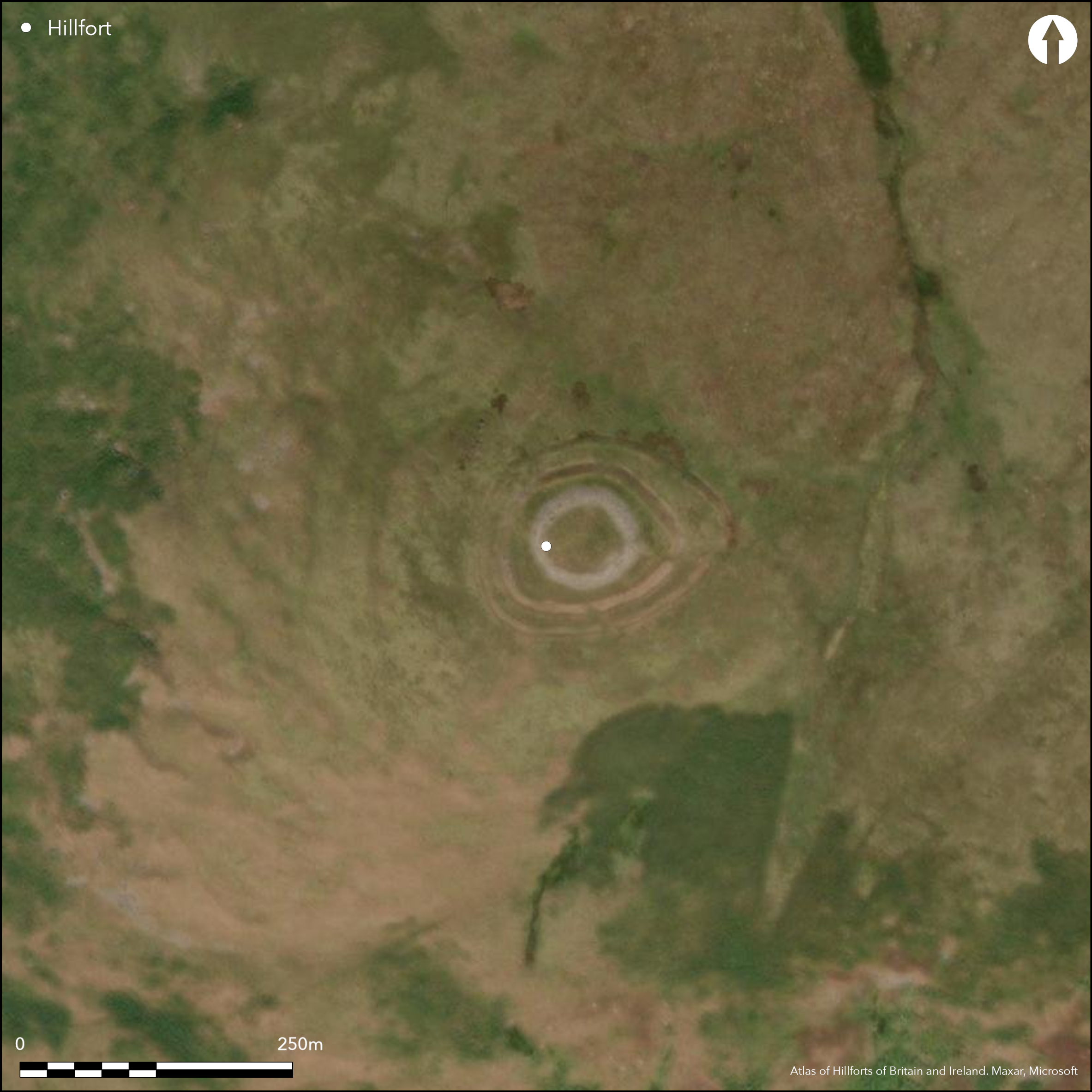
Situated on the summit of Arbory Hill, which is itself the W spur of the ridge of higher hills to the E, this is one of the higher forts in Scotland. Its defences reveal at least three phases of construction, in which an inner stone-walled enclosure has been inserted into the interior of a larger bi-vallate fort, which has itself replaced an earlier palisaded enclosure. The inner enclosure, which is roughly circular and measures 43m in internal diameter (0.14ha), was defended by a substantial wall, now spread up to 9.8m but probably originally in the order of 3m in thickness, and has entrances on the E and SW. This occupies the centre of the earlier fort, the interior of which measures 82m from E to W by 69m transversely (0.42ha). The earlier defences comprise two stone ramparts, each with an external ditch accompanied in places by a counterscarp bank; the inner of these ramparts forms a bank about 5.2m in thickness, standing no more than 0.8m in height internally, but up to 3m above the bottom of the ditch. The two lines are roughly concentric about 5m apart around the southern half of the circuit, but diverge to 8m on the NW, and as much as 20m on the ENE, to form the outer terminal of the staggered entrance in the outer rampart on the E. This is one of five entrances that penetrate both ramparts, the others being on the S, W, WNW and N respectively, but whereas the inner and outer gaps of those in the NW quadrant are roughly opposed, on the E and S the gaps are offset to expose the righthand side of approaching traffic; while these latter may be an expression of defensive architecture, they may also hint that the inner and outer ramparts of the outer circuits are not contemporary, the outer enclosing an overall area of 0.88ha. The evidence of the earlier timber perimeter is most clearly seen at the E entrance, where a minor outward deviation in the line of the inner rampart to create a slight stagger at the gap has revealed the line of the earlier palisade trench, which is otherwise mainly buried beneath the rampart round the rest of the circuit. Within the outer ramparts there are traces of the stances of at least seven timber round-houses, three of which had internal ring-ditches and lie within the inner enclosure.
Citizen Science: ✗
Reliability of Data: Confirmed
Reliability of Interpretation: Confirmed
X: -408803 Y: 7458828 (EPSG: 3857)
Longitude: -3.6723417686052 Latitude: 55.496495155937815 (EPSG:4326)
Country: Scotland
Current County or Unitary Authority: South Lanarkshire
Historic County: Lanarkshire
Current Parish/Community/Council/Townland: Lamington And Wandel
None
| Extant | ✓ |
| Cropmark | ✗ |
| Likely Destroyed | ✗ |
None
| Woodland | ✗ |
| Commercial Forestry Plantation | ✗ |
| Parkland | ✗ |
| Pasture (Grazing) | ✓ |
| Arable | ✗ |
| Scrub/Bracken | ✗ |
| Bare Outcrop | ✗ |
| Heather/Moorland | ✓ |
| Heath | ✗ |
| Built-up | ✗ |
| Coastal Grassland | ✗ |
| Other | ✗ |
None
| Contour Fort | ✓ |
| Partial Contour Fort | ✗ |
| Promontory Fort | ✗ |
| Hillslope Fort | ✗ |
| Level Terrain Fort | ✗ |
| Marsh Fort | ✗ |
| Multiple Enclosure Fort | ✓ |
| Hilltop | ✓ |
| Coastal Promontory | ✗ |
| Inland Promontory | ✗ |
| Valley Bottom | ✗ |
| Knoll/Hillock/Outcrop | ✗ |
| Ridge | ✗ |
| Cliff/Plateau-edge/Scarp | ✗ |
| Hillslope | ✗ |
| Lowland | ✗ |
| Spur | ✗ |
Dominant Topographic Feature: None
| North | ✗ |
| Northeast | ✗ |
| East | ✗ |
| Southeast | ✗ |
| South | ✗ |
| Southwest | ✗ |
| West | ✗ |
| Northwest | ✗ |
| Level | ✓ |
Altitude: 425.0m
N/A
In the absence of excavation, there are neither stratified artefacts nor radiocarbon dates to provide a chronology for the defences.
Reliability: D - None
| Pre 1200BC | ✗ |
| 1200BC - 800BC | ✗ |
| 800BC - 400BC | ✗ |
| 400BC - AD50 | ✗ |
| AD50 - AD400 | ✗ |
| AD400 - AD 800 | ✗ |
| Post AD800 | ✗ |
| Unknown | ✓ |
| Pre Hillfort: | None |
| Post Hillfort: | Stone-walled enclosure inserted into interior. Also overlain by rectangular hut and there are numerous small structures built into the inner wall, probably all of relatively recent date. |
First depicted in 1773 on Charles Ross's A map of the Shire of Lanark (1773), and thereafter on William Forrest's map of The County of Lanark from an Actual Survey (1816), it appears in slightly more detail on the 1st edition OS 6-inch map (Lanarkshire 1864, sheet 43). In 1889 it was sketch-planned by David Christison (Christison 1890, 302-4, fig 6). A chert scraper was found here in 1931 (Proc Soc Antiq Scot 66, 1931-2, 18). In 1959, the fort was surveyed by RCAHMS and in 1963 and 1975 revisited during the preparation of the County Inventory for Lanarkshire (RCAHMS 1978, 90-1, no.213, fig 45). It was visited by the OS in 1978. A prominent hill in Clydesdale adjacent to Roman monuments, it has been regularly photographed from the air, by CUCAP in 1945, 1949 and 1968, and by RCAHMS in 1976, 1980, 1982, 1985, 2000, 2003 and 2006. The palisades, along with adjacent cord rig, were first identified from photographs taken under snow in 1980. It was Scheduled in 1967
| 1st Identified Map Depiction (1773): | Charles Ross's A map of the Shire of Lanark (1773) |
| Other (1816): | William Forrest's map of The County of Lanark from an Actual Survey (1816) |
| Other (1859): | Annotated Camp on the 1st edition OS 6-inch map (Lanarkshire 1864, sheet 43) |
| Earthwork Survey (1889): | Sketch-plan and description by David Christison (1890, 302-4, fig 6) |
| Earthwork Survey (1959): | Plan and description during RCAHMS Survey of Marginal Lands (RCAHMS LAD 126/1-2) |
| Other (1963): | Visited by RCAHMS |
| Other (1967): | Scheduled |
| Other (1975): | Plan and description (RCAHMS 1978, 90-1, no.213, fig 45) |
| Other (1978): | Surveyed at 1:10.000 by the OS |
Within the outer ramparts there are traces of the stances of at least seven timber round-houses, three of which had internal ring-ditches and lie within the inner enclosure.
None
| None | ✓ |
| Spring | ✗ |
| Stream | ✗ |
| Pool | ✗ |
| Flush | ✗ |
| Well | ✗ |
| Other | ✗ |
Ring-ditch houses
| No Known Features | ✗ |
| Round Stone Structures | ✗ |
| Rectangular Stone Structures | ✗ |
| Curvilinear Platforms | ✓ |
| Other Roundhouse Evidence | ✓ |
| Pits | ✗ |
| Quarry Hollows | ✗ |
| Other | ✗ |
None
| No Known Excavation | ✓ |
| Pits | ✗ |
| Postholes | ✗ |
| Roundhouses | ✗ |
| Rectangular Structures | ✗ |
| Roads/Tracks | ✗ |
| Quarry Hollows | ✗ |
| Other | ✗ |
| Nothing Found | ✗ |
None
| No Known Geophysics | ✓ |
| Pits | ✗ |
| Roundhouses | ✗ |
| Rectangular Structures | ✗ |
| Roads/Tracks | ✗ |
| Quarry Hollows | ✗ |
| Other | ✗ |
| Nothing Found | ✗ |
Chert scraper was found here in 1931
| No Known Finds | ✗ |
| Pottery | ✗ |
| Metal | ✗ |
| Metalworking | ✗ |
| Human Bones | ✗ |
| Animal Bones | ✗ |
| Lithics | ✓ |
| Environmental | ✗ |
| Other | ✗ |
None
| APs Not Checked | ✗ |
| None | ✗ |
| Roundhouses | ✓ |
| Rectangular Structures | ✗ |
| Pits | ✗ |
| Postholes | ✗ |
| Roads/Tracks | ✗ |
| Other | ✗ |
See main summary
| 5: | In the outer circuits |
| 2: | None |
Guard Chambers: ✗
Chevaux de Frise: ✗
| 1. Simple Gap (North): | None |
| 2. Oblique (East): | Markedly staggered terminals in the outer, to expose the visitor's left side, and staggered gaps to expose right side |
| 3. Oblique (South): | Oblique approach exposing the right side |
| 3. Simple Gap (South): | Opposed rampart terminals |
| 4. Simple Gap (West): | Opposed rampart terminals |
| 5. Simple Gap (North west): | Opposed rampart terminals |
Twin ramparts and ditches with counterscarp banks; the inner enclosure is regarded here as a later insertion to an earlier fort
| Area 1: | 0.14ha. |
| Area 2: | 0.42ha. |
| Area 3: | 0.88ha. |
| Total: | 0.88ha. |
Total Footprint Area: 1.1ha.
None
| ✗ | None |
| ✓ | None |
| NE Quadrant: | 3 |
| SE Quadrant: | 3 |
| SW Quadrant: | 3 |
| NW Quadrant: | 3 |
| Total: | 3 |
| Partial Univallate | ✗ |
| Univallate | ✗ |
| Partial Bivallate | ✗ |
| Bivallate | ✗ |
| Partial Multivallate | ✗ |
| Multivallate | ✓ |
| Unknown | ✗ |
| Partial Univallate | ✗ |
| Univallate | ✓ |
| Partial Bivallate | ✗ |
| Bivallate | ✓ |
| Partial Multivallate | ✗ |
| Multivallate | ✗ |
None
| None | ✗ |
| Earthen Bank | ✓ |
| Stone Wall | ✓ |
| Rubble | ✗ |
| Wall-walk | ✗ |
| Evidence of Timber | ✗ |
| Vitrification | ✗ |
| Other Burning | ✗ |
| Palisade | ✓ |
| Counter Scarp Bank | ✓ |
| Berm | ✗ |
| Unfinished | ✗ |
| Other | ✗ |
None
| None | ✗ |
| Earthen Bank | ✗ |
| Stone Wall | ✗ |
| Murus Duplex | ✗ |
| Timber-framed | ✗ |
| Timber-laced | ✗ |
| Vitrification | ✗ |
| Other Burning | ✗ |
| Palisade | ✗ |
| Counter Scarp Bank | ✗ |
| Berm | ✗ |
| Unfinished | ✗ |
| No Known Excavation | ✓ |
| Other | ✗ |
| ✗ | None |
| ✓ | None |
Number of Ditches: 2
| ✗ | The expansion of the area between the ramparts here might be regarded as an annexe, but it might equally be related to the architectural configuration of the entrance here, opening onto the easiest line of approach, or indeed to the ramparts representing different periods of construction. |
Christison, D (1890) 'Forts, camps, and motes of the Upper Ward of Lanarkshire'. Proc Soc Antiq Scot 24 (1889-90), 281-352
Feachem, R (1963) A guide to prehistoric Scotland. Batsford: London (p 134)
RCAHMS (1978) The Royal Commission on the Ancient and Historical Monuments of Scotland. Lanarkshire: an inventory of the prehistoric and Roman monuments. HMSO: Edinburgh
Atlas of Hillforts:
Wikidata:
This work is licensed under CC BY-SA 4.0

 and should be cited as:
Lock, Gary and Ralston, Ian. 2024. Atlas of Hillforts of Britain and Ireland. Available at: https://hillforts.arch.ox.ac.uk
Document Version 1.1