Satellite Imagery
Satellite Imagery
HER: The West of Scotland Archaeology Service 10442 (None)
NMR: NS 92 NE 3 (47357)
SM: None
NGR: NS 9655 2702
X: 296550 Y: 627025 (OSGB36)
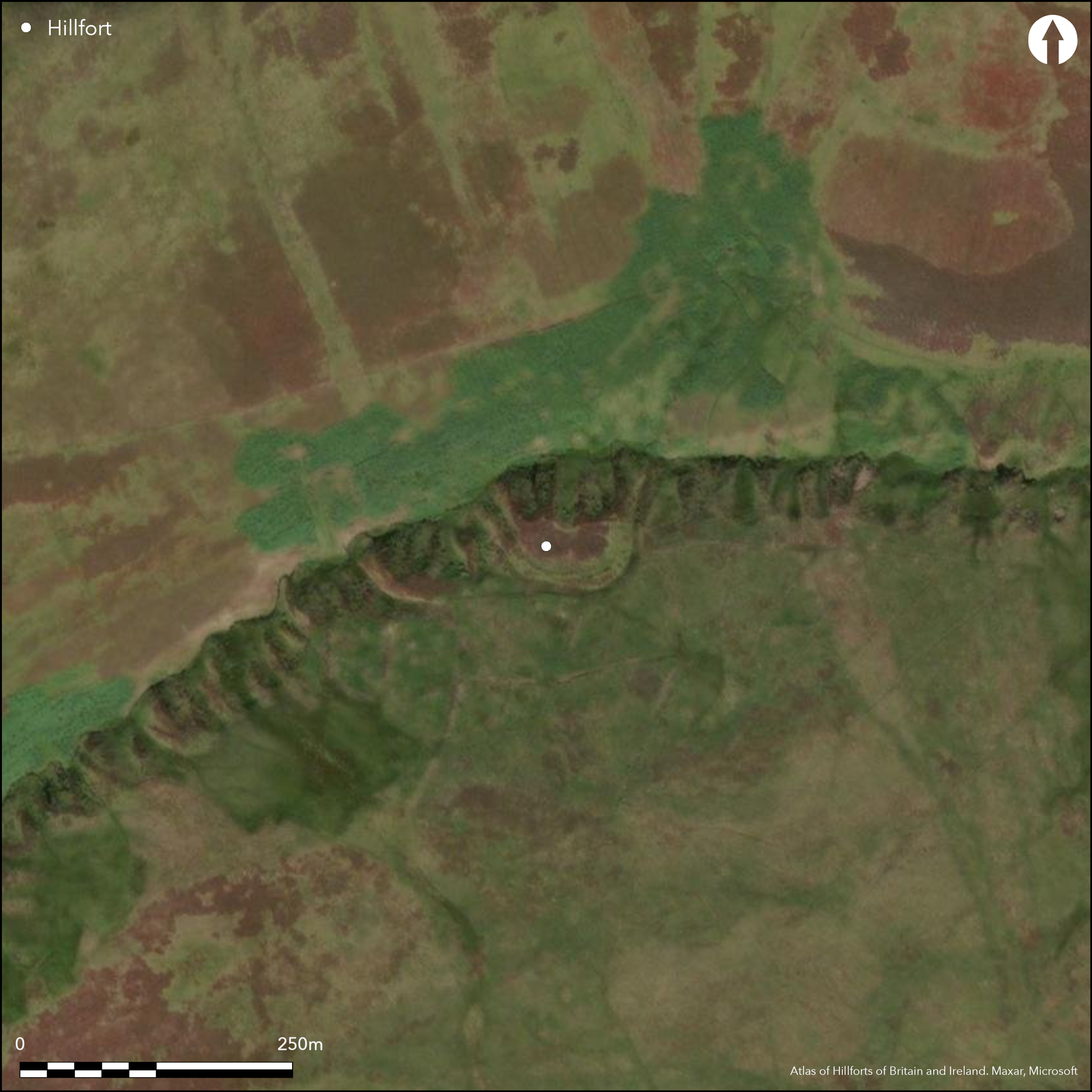
This small fortification utilises the steep S bank of the Shiel Burn, which here flows through a gorge some 20m deep, to provide protection along its N flank. Elsewhere, drawn in a broad D-shaped arc, there is an earthen rampart measuring up to 9m in thickness by 1.5m in internal height, with an external ditch up to 6m in breadth; a low counterscarp bank can be seen on the SW. The interior measures 52m from E to W by 27m transversely (0.12ha) and the entrance is probably on the E, where the rampart terminates short of the edge of the gully. Apart from a later turf-bank, which follows the line of the rampart and extends along the lip of the gorge, the interior is featureless.
Citizen Science: ✗
Reliability of Data: Confirmed
Reliability of Interpretation: Confirmed
X: -405239 Y: 7464629 (EPSG: 3857)
Longitude: -3.6403235633960116 Latitude: 55.52600091903553 (EPSG:4326)
Country: Scotland
Current County or Unitary Authority: South Lanarkshire
Historic County: Lanarkshire
Current Parish/Community/Council/Townland: Lamington And Wandel
None
| Extant | ✓ |
| Cropmark | ✗ |
| Likely Destroyed | ✗ |
None
| Woodland | ✗ |
| Commercial Forestry Plantation | ✗ |
| Parkland | ✗ |
| Pasture (Grazing) | ✓ |
| Arable | ✗ |
| Scrub/Bracken | ✗ |
| Bare Outcrop | ✗ |
| Heather/Moorland | ✓ |
| Heath | ✗ |
| Built-up | ✗ |
| Coastal Grassland | ✗ |
| Other | ✗ |
In effect the edge of the gorge here forms a shallow promontory.
| Contour Fort | ✗ |
| Partial Contour Fort | ✗ |
| Promontory Fort | ✗ |
| Hillslope Fort | ✓ |
| Level Terrain Fort | ✗ |
| Marsh Fort | ✗ |
| Multiple Enclosure Fort | ✗ |
| Hilltop | ✗ |
| Coastal Promontory | ✗ |
| Inland Promontory | ✗ |
| Valley Bottom | ✗ |
| Knoll/Hillock/Outcrop | ✗ |
| Ridge | ✗ |
| Cliff/Plateau-edge/Scarp | ✓ |
| Hillslope | ✓ |
| Lowland | ✗ |
| Spur | ✗ |
Dominant Topographic Feature: None
| North | ✗ |
| Northeast | ✗ |
| East | ✗ |
| Southeast | ✗ |
| South | ✗ |
| Southwest | ✗ |
| West | ✗ |
| Northwest | ✓ |
| Level | ✗ |
Altitude: 305.0m
N/A
In the absence of excavation, there are neither stratified artefacts nor radiocarbon dates to provide a chronology for the defences.
Reliability: D - None
| Pre 1200BC | ✗ |
| 1200BC - 800BC | ✗ |
| 800BC - 400BC | ✗ |
| 400BC - AD50 | ✗ |
| AD50 - AD400 | ✗ |
| AD400 - AD 800 | ✗ |
| Post AD800 | ✗ |
| Unknown | ✓ |
| Pre Hillfort: | None |
| Post Hillfort: | Overlain by post-medieval turf-banked enclosure |
First depicted as a 'Camp' on William Forest's map of The County of Lanark from Actual Survey (1816), it is shown in more detail in 1859 on the 1st edition OS 25-inch map (Lanarkshire 1864, sheet 43.6), it was visited and sketch-planned by David Christison in 1889 (Christison 1890, 304-6, fig 8). It was visited by the OS in 1955 and 1973, and by RCAHMS in 1963, who prepared a plan in 1970 for the County Inventory of Lanarkshire (RCAHMS 1978, 154, no.317, fig 100).
| 1st Identified Map Depiction (1816): | William Forest's map of The County of Lanark from Actual Survey (1816) |
| Other (1859): | Annotated Camp on the 1st edition OS 25-inch map (Lanarkshire 1864, sheet 43.6) |
| Earthwork Survey (1889): | Sketch-plan and description by David Christison (1890, 304-6, fig 8) |
| Other (1955): | Visited by the OS |
| Other (1963): | Visited by RCAHMS |
| Earthwork Survey (1970): | Plan and description (RCAHMS 1978, 154, no.317, fig 100; RCAHMS LAD 166/1-2) |
| Other (1973): | Visited by the OS |
Featureless apart from the post-medieval turf-banked enclosure
None
| None | ✓ |
| Spring | ✗ |
| Stream | ✗ |
| Pool | ✗ |
| Flush | ✗ |
| Well | ✗ |
| Other | ✗ |
None
| No Known Features | ✓ |
| Round Stone Structures | ✗ |
| Rectangular Stone Structures | ✗ |
| Curvilinear Platforms | ✗ |
| Other Roundhouse Evidence | ✗ |
| Pits | ✗ |
| Quarry Hollows | ✗ |
| Other | ✗ |
None
| No Known Excavation | ✓ |
| Pits | ✗ |
| Postholes | ✗ |
| Roundhouses | ✗ |
| Rectangular Structures | ✗ |
| Roads/Tracks | ✗ |
| Quarry Hollows | ✗ |
| Other | ✗ |
| Nothing Found | ✗ |
None
| No Known Geophysics | ✓ |
| Pits | ✗ |
| Roundhouses | ✗ |
| Rectangular Structures | ✗ |
| Roads/Tracks | ✗ |
| Quarry Hollows | ✗ |
| Other | ✗ |
| Nothing Found | ✗ |
None
| No Known Finds | ✓ |
| Pottery | ✗ |
| Metal | ✗ |
| Metalworking | ✗ |
| Human Bones | ✗ |
| Animal Bones | ✗ |
| Lithics | ✗ |
| Environmental | ✗ |
| Other | ✗ |
NO APPARENT FEATURES
| APs Not Checked | ✗ |
| None | ✓ |
| Roundhouses | ✗ |
| Rectangular Structures | ✗ |
| Pits | ✗ |
| Postholes | ✗ |
| Roads/Tracks | ✗ |
| Other | ✗ |
See main summary
| 1: | None |
| 2: | None |
Guard Chambers: ✗
Chevaux de Frise: ✗
| 1. Simple Gap (East): | None |
Single rampart and ditch, with traces of a counterscarp bank, cutting off what is in effect a shallow promontory
| Area 1: | 0.12ha. |
| Total: | 0.12ha. |
Total Footprint Area: 0.24ha.
None
| ✗ | None |
| ✗ | None |
| NE Quadrant: | 0 |
| SE Quadrant: | 1 |
| SW Quadrant: | 1 |
| NW Quadrant: | 0 |
| Total: | 1 |
| Partial Univallate | ✓ |
| Univallate | ✗ |
| Partial Bivallate | ✗ |
| Bivallate | ✗ |
| Partial Multivallate | ✗ |
| Multivallate | ✗ |
| Unknown | ✗ |
| Partial Univallate | ✗ |
| Univallate | ✗ |
| Partial Bivallate | ✗ |
| Bivallate | ✗ |
| Partial Multivallate | ✗ |
| Multivallate | ✗ |
None
| None | ✗ |
| Earthen Bank | ✓ |
| Stone Wall | ✗ |
| Rubble | ✗ |
| Wall-walk | ✗ |
| Evidence of Timber | ✗ |
| Vitrification | ✗ |
| Other Burning | ✗ |
| Palisade | ✗ |
| Counter Scarp Bank | ✓ |
| Berm | ✗ |
| Unfinished | ✗ |
| Other | ✗ |
None
| None | ✗ |
| Earthen Bank | ✗ |
| Stone Wall | ✗ |
| Murus Duplex | ✗ |
| Timber-framed | ✗ |
| Timber-laced | ✗ |
| Vitrification | ✗ |
| Other Burning | ✗ |
| Palisade | ✗ |
| Counter Scarp Bank | ✗ |
| Berm | ✗ |
| Unfinished | ✗ |
| No Known Excavation | ✓ |
| Other | ✗ |
| ✗ | None |
| ✓ | None |
Number of Ditches: 1
| ✗ | None |
Christison, D (1890) 'Forts, camps, and motes of the Upper Ward of Lanarkshire'. Proc Soc Antiq Scot 24 (1889-90), 281-352
RCAHMS (1978) The Royal Commission on the Ancient and Historical Monuments of Scotland. Lanarkshire: an inventory of the prehistoric and Roman monuments. HMSO: Edinburgh
Atlas of Hillforts:
Wikidata:
This work is licensed under CC BY-SA 4.0![]()
![]()
![]() and should be cited as:
and should be cited as:
Lock, Gary and Ralston, Ian. 2024. Atlas of Hillforts of Britain and Ireland. Available at: https://hillforts.arch.ox.ac.uk
Document Version 1.1