
LiDAR 1m DTM Hillshade
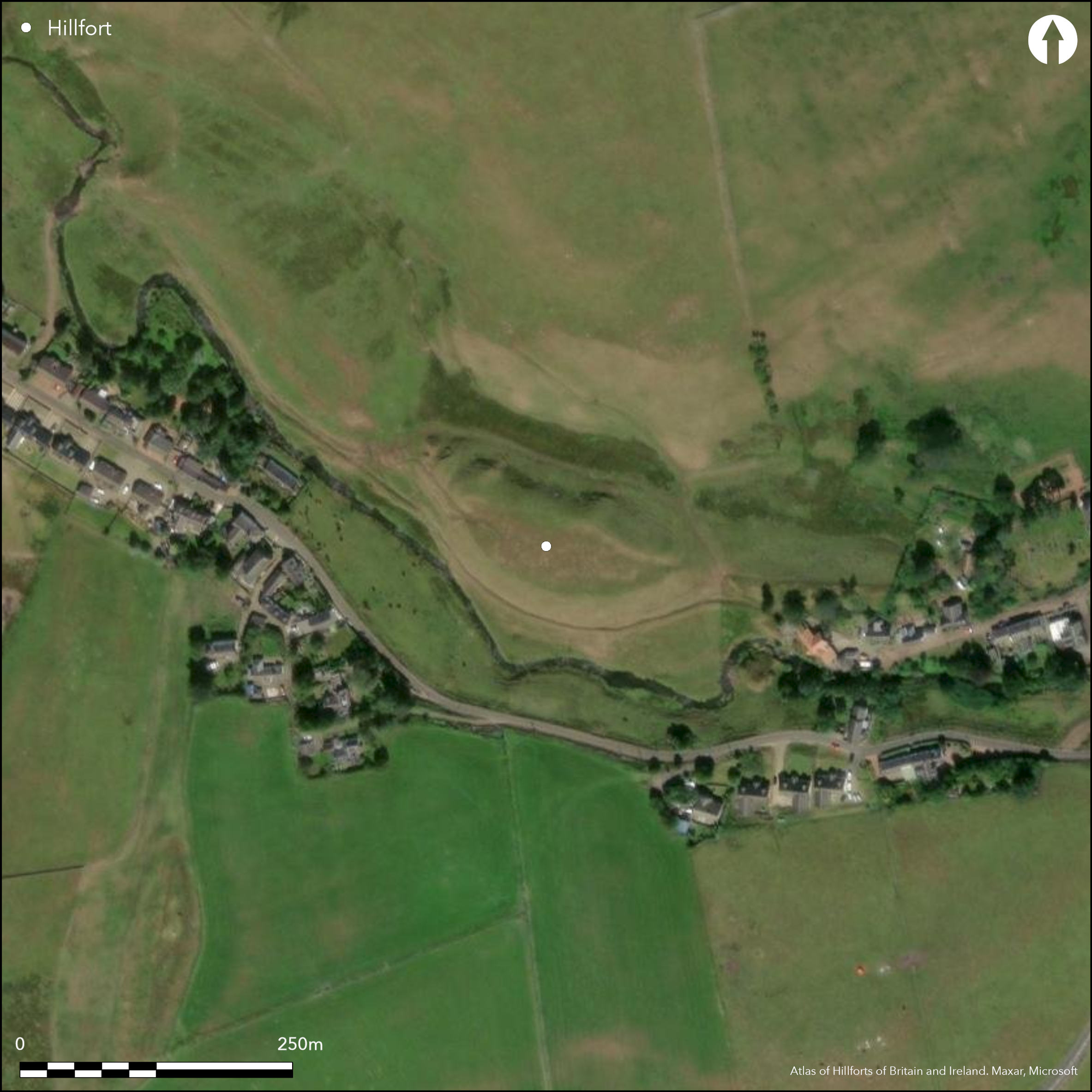
Satellite Imagery
LiDAR 1m DTM Hillshade
Satellite Imagery
Scroll left/right to view further images.
HER: The West of Scotland Archaeology Service 10449 (None)
NMR: NS 92 NW 1 (47364)
SM: 2596
NGR: NS 9425 2871
X: 294250 Y: 628710 (OSGB36)
What may be the remains of a fort is situated in Roberton village on a steep-sided hillock that is formed between the N bank of the Roberton Burn and a glacial outwash channel. Roughly D-shaped on plan, it measures about 110m from ESE to WNW along the chord by a maximum of 37m transversely (0.3ha) within a heavily degraded rampart, which at the WNW end is apparently accompanied by two rock-cut ditches cutting across the spine of the hillock. There are entrances at both ends, that on the WNW now blocked by the bank of a rectilinear enclosure that is probably associated with a rectangular building at the foot of the slope. Another old field-bank can be seen traversing the WNW end of the interior, which has probably been cultivated.
Citizen Science: ✗
Reliability of Data: Confirmed
Reliability of Interpretation: Confirmed
X: -409365 Y: 7467509 (EPSG: 3857)
Longitude: -3.6773852160374467 Latitude: 55.54064197514389 (EPSG:4326)
Country: Scotland
Current County or Unitary Authority: South Lanarkshire
Historic County: Lanarkshire
Current Parish/Community/Council/Townland: Wiston And Roberton
None
| Extant | ✓ |
| Cropmark | ✗ |
| Likely Destroyed | ✗ |
None
| Woodland | ✗ |
| Commercial Forestry Plantation | ✗ |
| Parkland | ✗ |
| Pasture (Grazing) | ✓ |
| Arable | ✗ |
| Scrub/Bracken | ✗ |
| Bare Outcrop | ✗ |
| Heather/Moorland | ✓ |
| Heath | ✗ |
| Built-up | ✗ |
| Coastal Grassland | ✗ |
| Other | ✗ |
None
| Contour Fort | ✓ |
| Partial Contour Fort | ✗ |
| Promontory Fort | ✗ |
| Hillslope Fort | ✗ |
| Level Terrain Fort | ✗ |
| Marsh Fort | ✗ |
| Multiple Enclosure Fort | ✗ |
| Hilltop | ✗ |
| Coastal Promontory | ✗ |
| Inland Promontory | ✗ |
| Valley Bottom | ✓ |
| Knoll/Hillock/Outcrop | ✗ |
| Ridge | ✗ |
| Cliff/Plateau-edge/Scarp | ✗ |
| Hillslope | ✗ |
| Lowland | ✗ |
| Spur | ✗ |
Dominant Topographic Feature: None
| North | ✗ |
| Northeast | ✗ |
| East | ✗ |
| Southeast | ✗ |
| South | ✗ |
| Southwest | ✗ |
| West | ✗ |
| Northwest | ✗ |
| Level | ✓ |
Altitude: 230.0m
N/A
In the absence of excavation, there are neither stratified artefacts nor radiocarbon dates to provide a chronology for the defences.
Reliability: D - None
| Pre 1200BC | ✗ |
| 1200BC - 800BC | ✗ |
| 800BC - 400BC | ✗ |
| 400BC - AD50 | ✗ |
| AD50 - AD400 | ✗ |
| AD400 - AD 800 | ✗ |
| Post AD800 | ✗ |
| Unknown | ✓ |
| Pre Hillfort: | None |
| Post Hillfort: | Overlain by post medieval enclosures and probably ploughed |
First depicted on the 1st edition OS 25-inch map (Lanarkshire 1859, sheets 43.1-2), it was described in 1942 during the RCAHMS Emergency Surveys, but subsequently omitted from the prehistoric volume of the County Inventory for Lanarkshire on the grounds that the earthworks were probably medieval. It was visited in 1952 during the survey of the route of the Roman Road (Radford et al 1953, 33), when it was described as 'a small fort of the sub-Roman or early medieval period', one of the authors subsequently speculating that the occupants of the Roberton Motte probably moved here to establish a manor, the main evidence simply being the site of a medieval chapel here and the presence of a mill (Reid 1957, 141-2). While there is no disputing the proximity of the church and village, there is no immutable evidence that these are castle earthworks, and the topographical characteristics of the site are such that it is as likely to have been fortified in earlier periods. It was visited by the OS in 1955 and resurveyed at 1:2500 in 1978; it was Scheduled in 1967.
| 1st Identified Map Depiction (1859): | Named in Gothic type on the 1st edition OS 25-inch map (Lanarkshire 1859, sheets 43.1-2) |
| Other (1942): | Description by Angus Graham and Gordon Childe for the RCAHMS wartime Emergency Surveys |
| Other (1952): | Visited (Radford et al 1953, 33) |
| Other (1955): | Visited by the OS |
| Other (1967): | Scheduled |
| Other (1978): | Resurveyed at 1:2500 by the OS |
Probably ploughed and no coherent features can be seen.
None
| None | ✓ |
| Spring | ✗ |
| Stream | ✗ |
| Pool | ✗ |
| Flush | ✗ |
| Well | ✗ |
| Other | ✗ |
None
| No Known Features | ✓ |
| Round Stone Structures | ✗ |
| Rectangular Stone Structures | ✗ |
| Curvilinear Platforms | ✗ |
| Other Roundhouse Evidence | ✗ |
| Pits | ✗ |
| Quarry Hollows | ✗ |
| Other | ✗ |
None
| No Known Excavation | ✓ |
| Pits | ✗ |
| Postholes | ✗ |
| Roundhouses | ✗ |
| Rectangular Structures | ✗ |
| Roads/Tracks | ✗ |
| Quarry Hollows | ✗ |
| Other | ✗ |
| Nothing Found | ✗ |
None
| No Known Geophysics | ✓ |
| Pits | ✗ |
| Roundhouses | ✗ |
| Rectangular Structures | ✗ |
| Roads/Tracks | ✗ |
| Quarry Hollows | ✗ |
| Other | ✗ |
| Nothing Found | ✗ |
None
| No Known Finds | ✓ |
| Pottery | ✗ |
| Metal | ✗ |
| Metalworking | ✗ |
| Human Bones | ✗ |
| Animal Bones | ✗ |
| Lithics | ✗ |
| Environmental | ✗ |
| Other | ✗ |
NO APPARENT FEATURES
| APs Not Checked | ✗ |
| None | ✓ |
| Roundhouses | ✗ |
| Rectangular Structures | ✗ |
| Pits | ✗ |
| Postholes | ✗ |
| Roads/Tracks | ✗ |
| Other | ✗ |
See main summary
| 2: | None |
| 2: | None |
Guard Chambers: ✗
Chevaux de Frise: ✗
| 1. Simple Gap (East): | None |
| 2. Simple Gap (West): | Too mutilated to discern its character |
Single rampart of earth and stones, accompanied by ditches at one end
| Area 1: | 0.3ha. |
| Total: | 0.3ha. |
Total Footprint Area: Noneha.
None
| ✗ | None |
| ✓ | None |
| NE Quadrant: | 1 |
| SE Quadrant: | 1 |
| SW Quadrant: | 1 |
| NW Quadrant: | 1 |
| Total: | 1 |
| Partial Univallate | ✗ |
| Univallate | ✓ |
| Partial Bivallate | ✗ |
| Bivallate | ✗ |
| Partial Multivallate | ✗ |
| Multivallate | ✗ |
| Unknown | ✗ |
| Partial Univallate | ✗ |
| Univallate | ✗ |
| Partial Bivallate | ✗ |
| Bivallate | ✗ |
| Partial Multivallate | ✗ |
| Multivallate | ✗ |
None
| None | ✗ |
| Earthen Bank | ✓ |
| Stone Wall | ✗ |
| Rubble | ✗ |
| Wall-walk | ✗ |
| Evidence of Timber | ✗ |
| Vitrification | ✗ |
| Other Burning | ✗ |
| Palisade | ✗ |
| Counter Scarp Bank | ✗ |
| Berm | ✗ |
| Unfinished | ✗ |
| Other | ✗ |
None
| None | ✗ |
| Earthen Bank | ✗ |
| Stone Wall | ✗ |
| Murus Duplex | ✗ |
| Timber-framed | ✗ |
| Timber-laced | ✗ |
| Vitrification | ✗ |
| Other Burning | ✗ |
| Palisade | ✗ |
| Counter Scarp Bank | ✗ |
| Berm | ✗ |
| Unfinished | ✗ |
| No Known Excavation | ✓ |
| Other | ✗ |
| ✗ | None |
| ✓ | At the WNW end, but otherwise invisible elsewhere on the circuit. |
Number of Ditches: 2
| ✗ | None |
Radford, C A R, Reid, R C, Robertson, J and Truckell, A E (1953) 'Roman Roads in SW Scotland. (4) From Castledykes (Corbiehall) to Crawford'. Trans Dumfriesshire Galloway Natur Hist Antiq Soc, 3 Ser, 31 (1952-3), 30-4
Reid, R C (1957) 'Castledykes, Roberton'. Trans Dumfriesshire Galloway Natur Hist Antiq Soc, 3 Ser, 35 (1956-7), 141-2
Atlas of Hillforts:
Wikidata:
This work is licensed under CC BY-SA 4.0![]()
![]()
![]() and should be cited as:
and should be cited as:
Lock, Gary and Ralston, Ian. 2024. Atlas of Hillforts of Britain and Ireland. Available at: https://hillforts.arch.ox.ac.uk
Document Version 1.1