Satellite Imagery
Satellite Imagery
HER: The West of Scotland Archaeology Service 10501 (None)
NMR: NS 92 SW 1 (47416)
SM: 2606
NGR: NS 9085 2392
X: 290850 Y: 623920 (OSGB36)
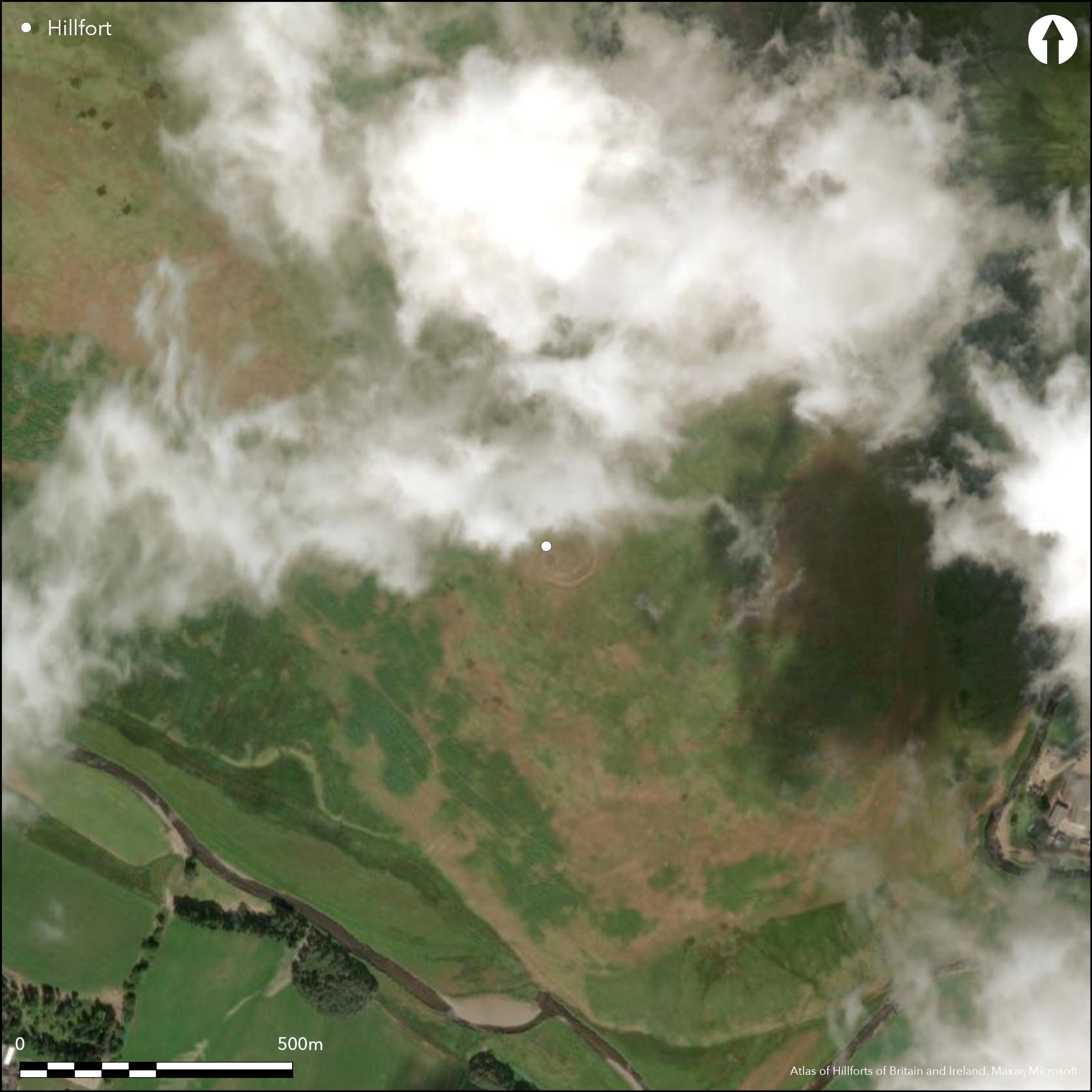
This fort, which is situated on the crest of the SE spur of Black Hill, displays evidence of at least three periods of construction, the latest of which is probably the stone-built inner enclosure. Roughly circular on plan, this measures about 38m from NE to SW by 35m transversely (0.1ha) within a wall reduced to a mound of rubble up to 6m in thickness, and there is a well defined entrance aligned on a gap in the earlier circuit on the NE. The latter takes in an area measuring 64m from E to W by 58m transversely (0.29ha) and has a second entrance on the NW; this has no corresponding gap in the inner wall, thus implying that the inner wall is later. In the opinion of the RCAHMS investigators who surveyed the fort in 1975, however, the rampart of the outer circuit, which measures 7.3m in thickness and up to 0.8m in internal height, is capped with the remains of a substantial stone wall; this they associated with the inner enclosure. Whether this is correct must await further work, but there is no doubt that the outer line is accompanied by an internal quarry around most of its circuit, and an external ditch, which presumably provided all the materials for its construction. On the NW and SE, there is also a counterscarp bank, in the latter sector overlying an earlier palisade trench that can be seen looping out from beneath it. A single house platform can be seen within the inner enclosure, which is also overlain by a 19th century sheepfold.
Citizen Science: ✗
Reliability of Data: Confirmed
Reliability of Interpretation: Confirmed
X: -415149 Y: 7458902 (EPSG: 3857)
Longitude: -3.729350209398253 Latitude: 55.496871536077954 (EPSG:4326)
Country: Scotland
Current County or Unitary Authority: South Lanarkshire
Historic County: Lanarkshire
Current Parish/Community/Council/Townland: Crawfordjohn
None
| Extant | ✓ |
| Cropmark | ✗ |
| Likely Destroyed | ✗ |
None
| Woodland | ✗ |
| Commercial Forestry Plantation | ✗ |
| Parkland | ✗ |
| Pasture (Grazing) | ✓ |
| Arable | ✓ |
| Scrub/Bracken | ✗ |
| Bare Outcrop | ✗ |
| Heather/Moorland | ✗ |
| Heath | ✗ |
| Built-up | ✗ |
| Coastal Grassland | ✗ |
| Other | ✗ |
None
| Contour Fort | ✓ |
| Partial Contour Fort | ✗ |
| Promontory Fort | ✗ |
| Hillslope Fort | ✗ |
| Level Terrain Fort | ✗ |
| Marsh Fort | ✗ |
| Multiple Enclosure Fort | ✗ |
| Hilltop | ✓ |
| Coastal Promontory | ✗ |
| Inland Promontory | ✗ |
| Valley Bottom | ✗ |
| Knoll/Hillock/Outcrop | ✗ |
| Ridge | ✗ |
| Cliff/Plateau-edge/Scarp | ✗ |
| Hillslope | ✗ |
| Lowland | ✗ |
| Spur | ✓ |
Dominant Topographic Feature: None
| North | ✗ |
| Northeast | ✗ |
| East | ✗ |
| Southeast | ✗ |
| South | ✗ |
| Southwest | ✗ |
| West | ✗ |
| Northwest | ✗ |
| Level | ✓ |
Altitude: 335.0m
N/A
In the absence of excavation, there are neither stratified artefacts nor radiocarbon dates to provide a chronology for the defences.
Reliability: D - None
| Pre 1200BC | ✗ |
| 1200BC - 800BC | ✗ |
| 800BC - 400BC | ✗ |
| 400BC - AD50 | ✗ |
| AD50 - AD400 | ✗ |
| AD400 - AD 800 | ✗ |
| Post AD800 | ✗ |
| Unknown | ✓ |
| Pre Hillfort: | Palisade overlain by counterscarp rampart of phase I fort |
| Post Hillfort: | 19th century sheepfold built within the interior |
First annotated 'Encampt.' on Charles Ross's Map of the Shire of Lanark (1773), it also appears on William Forrest's map of The County of Lanark from an Actual Survey (1816), and is depicted as a single perimeter on the 1st edition OS 25-inch map (Lanarkshire 1863, sheet 42.16). It was sketch-planned and described by David Christison in 1889 (Christison 1890, 317-19, fig 17). It was first visited by RCAHMS in 1942 as part of the Emergency Survey programme, and again in 1963 for inclusion in the County Inventory for Lanarkshire (RCAHMS 1978, 92-4, no.216, fig 47), before it was planned in 1975. It was visited by the OS in 1978, but the palisade was only identified as the result of informal fieldwork by SH to examine traces of cord rig in the vicinity in the 1980s; it was revisited by RCAHMS in 1996. The palisade is clearly visible on some of the aerial photographs taken by RCAHMS in 1981, 1996 and 2006. The fort was Scheduled in 1967.
| 1st Identified Map Depiction (1773): | Charles Ross, Map of the Shire of Lanark (1773) |
| Other (1816): | William Forrest's map of The County of Lanark from an Actual Survey (1816) |
| Other (1858): | Annotated Camp on the 1st edition OS 25-inch map (Lanarkshire 1863, sheet 42.16) |
| Earthwork Survey (1889): | Sketch plan and description by David Christison (1890, 317-19, fig 17) |
| Other (1942): | Description by Angus Graham and Gordon Childe for the RCAHMS wartime Emergency Surveys |
| Other (1963): | Visited by RCAHMS |
| Other (1967): | Scheduled |
| Earthwork Survey (1975): | Plan and description (RCAHMS 1978, 92-4, no.216, fig 47; RCAHMS LAD 128/1-2) |
| Other (1978): | Surveyed at 1:10.000 by the OS |
| Other (1996): | Description by RCAHMS |
Single house platform within inner enclosure
None
| None | ✓ |
| Spring | ✗ |
| Stream | ✗ |
| Pool | ✗ |
| Flush | ✗ |
| Well | ✗ |
| Other | ✗ |
None
| No Known Features | ✗ |
| Round Stone Structures | ✗ |
| Rectangular Stone Structures | ✗ |
| Curvilinear Platforms | ✓ |
| Other Roundhouse Evidence | ✗ |
| Pits | ✗ |
| Quarry Hollows | ✓ |
| Other | ✗ |
None
| No Known Excavation | ✓ |
| Pits | ✗ |
| Postholes | ✗ |
| Roundhouses | ✗ |
| Rectangular Structures | ✗ |
| Roads/Tracks | ✗ |
| Quarry Hollows | ✗ |
| Other | ✗ |
| Nothing Found | ✗ |
None
| No Known Geophysics | ✓ |
| Pits | ✗ |
| Roundhouses | ✗ |
| Rectangular Structures | ✗ |
| Roads/Tracks | ✗ |
| Quarry Hollows | ✗ |
| Other | ✗ |
| Nothing Found | ✗ |
None
| No Known Finds | ✓ |
| Pottery | ✗ |
| Metal | ✗ |
| Metalworking | ✗ |
| Human Bones | ✗ |
| Animal Bones | ✗ |
| Lithics | ✗ |
| Environmental | ✗ |
| Other | ✗ |
None
| APs Not Checked | ✗ |
| None | ✗ |
| Roundhouses | ✓ |
| Rectangular Structures | ✗ |
| Pits | ✗ |
| Postholes | ✗ |
| Roads/Tracks | ✗ |
| Other | ✗ |
See main summary
| 2: | None |
| 2: | None |
Guard Chambers: ✗
Chevaux de Frise: ✗
| 1. Simple Gap (North east): | None |
| 2. Simple Gap (North west): | None |
For the purposes of the Atlas, the outer line is treated as the fort, and the inner enclosure is omitted from these fields
| Area 1: | 0.3ha. |
| Total: | 0.3ha. |
Total Footprint Area: 0.5ha.
None
| ✓ | None |
| ✓ | This omits the small inner enclosure |
| NE Quadrant: | 1 |
| SE Quadrant: | 1 |
| SW Quadrant: | 1 |
| NW Quadrant: | 1 |
| Total: | 1 |
| Partial Univallate | ✗ |
| Univallate | ✓ |
| Partial Bivallate | ✗ |
| Bivallate | ✗ |
| Partial Multivallate | ✗ |
| Multivallate | ✗ |
| Unknown | ✗ |
| Partial Univallate | ✗ |
| Univallate | ✗ |
| Partial Bivallate | ✗ |
| Bivallate | ✗ |
| Partial Multivallate | ✗ |
| Multivallate | ✗ |
Grass-grown rubble bank; counterscarp bank overlies earlier palisade trench
| None | ✗ |
| Earthen Bank | ✗ |
| Stone Wall | ✗ |
| Rubble | ✓ |
| Wall-walk | ✗ |
| Evidence of Timber | ✗ |
| Vitrification | ✗ |
| Other Burning | ✗ |
| Palisade | ✓ |
| Counter Scarp Bank | ✓ |
| Berm | ✗ |
| Unfinished | ✗ |
| Other | ✗ |
None
| None | ✗ |
| Earthen Bank | ✗ |
| Stone Wall | ✗ |
| Murus Duplex | ✗ |
| Timber-framed | ✗ |
| Timber-laced | ✗ |
| Vitrification | ✗ |
| Other Burning | ✗ |
| Palisade | ✗ |
| Counter Scarp Bank | ✗ |
| Berm | ✗ |
| Unfinished | ✗ |
| No Known Excavation | ✓ |
| Other | ✗ |
| ✗ | None |
| ✓ | None |
Number of Ditches: 1
| ✗ | None |
Christison, D (1890) 'Forts, camps, and motes of the Upper Ward of Lanarkshire'. Proc Soc Antiq Scot 24 (1889-90), 281-352
Feachem, R (1963) A guide to prehistoric Scotland. Batsford: London (p 134)
RCAHMS (1978) The Royal Commission on the Ancient and Historical Monuments of Scotland. Lanarkshire: an inventory of the prehistoric and Roman monuments. HMSO: Edinburgh
Atlas of Hillforts:
Wikidata:
This work is licensed under CC BY-SA 4.0![]()
![]()
![]() and should be cited as:
and should be cited as:
Lock, Gary and Ralston, Ian. 2024. Atlas of Hillforts of Britain and Ireland. Available at: https://hillforts.arch.ox.ac.uk
Document Version 1.1