Satellite Imagery
Satellite Imagery
HER: The West of Scotland Archaeology Service 10509 (None)
NMR: NS 92 SW 17 (47424)
SM: 2614
NGR: NS 9355 2188
X: 293550 Y: 621880 (OSGB36)
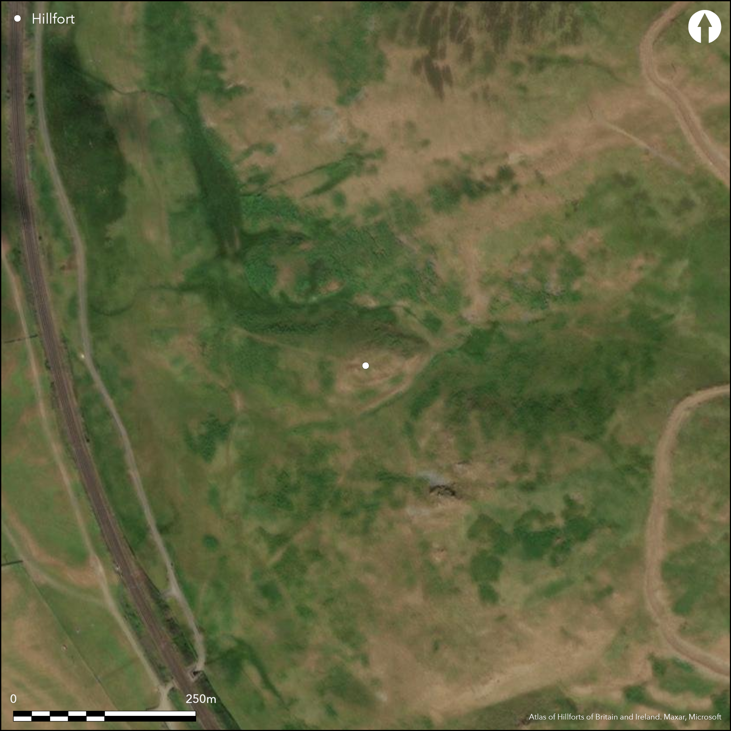
This small fortification occupies a steep-sided hillock formed between deep natural gullies on the SW flank of Castle Hill. Oval on plan, it measures 39m from E to W by 20m transversely (0.06ha) within a thick wall reduced to a band of rubble extending along the lip of the hillock. The entrance is on the W, at the lower end of the interior, which drops quite steeply and contains evidence of at least three house platforms. The natural strength of the location has been further enhanced by the digging of a ditch into the bottom of the gullies at the foot of the hillock on the S and NE to create an outwork with a stone revetted rampart; the latter can be traced as a low scarp around the N and W, its stature and two broad gaps contributing to the suggestion by RCAHMS investigators that it was perhaps unfinished.
Citizen Science: ✗
Reliability of Data: Confirmed
Reliability of Interpretation: Confirmed
X: -410307 Y: 7455419 (EPSG: 3857)
Longitude: -3.6858484626197447 Latitude: 55.47914474096954 (EPSG:4326)
Country: Scotland
Current County or Unitary Authority: South Lanarkshire
Historic County: Lanarkshire
Current Parish/Community/Council/Townland: Crawford
None
| Extant | ✓ |
| Cropmark | ✗ |
| Likely Destroyed | ✗ |
None
| Woodland | ✗ |
| Commercial Forestry Plantation | ✗ |
| Parkland | ✗ |
| Pasture (Grazing) | ✓ |
| Arable | ✗ |
| Scrub/Bracken | ✗ |
| Bare Outcrop | ✗ |
| Heather/Moorland | ✓ |
| Heath | ✗ |
| Built-up | ✗ |
| Coastal Grassland | ✗ |
| Other | ✗ |
None
| Contour Fort | ✓ |
| Partial Contour Fort | ✗ |
| Promontory Fort | ✗ |
| Hillslope Fort | ✗ |
| Level Terrain Fort | ✗ |
| Marsh Fort | ✗ |
| Multiple Enclosure Fort | ✗ |
| Hilltop | ✗ |
| Coastal Promontory | ✗ |
| Inland Promontory | ✗ |
| Valley Bottom | ✗ |
| Knoll/Hillock/Outcrop | ✓ |
| Ridge | ✗ |
| Cliff/Plateau-edge/Scarp | ✗ |
| Hillslope | ✗ |
| Lowland | ✗ |
| Spur | ✗ |
Dominant Topographic Feature: None
| North | ✗ |
| Northeast | ✗ |
| East | ✗ |
| Southeast | ✗ |
| South | ✗ |
| Southwest | ✗ |
| West | ✗ |
| Northwest | ✗ |
| Level | ✓ |
Altitude: 290.0m
N/A
In the absence of excavation, there are neither stratified artefacts nor radiocarbon dates to provide a chronology for the defences.
Reliability: D - None
| Pre 1200BC | ✗ |
| 1200BC - 800BC | ✗ |
| 800BC - 400BC | ✗ |
| 400BC - AD50 | ✗ |
| AD50 - AD400 | ✗ |
| AD400 - AD 800 | ✗ |
| Post AD800 | ✗ |
| Unknown | ✓ |
| Pre Hillfort: | None |
| Post Hillfort: | None |
Certainly depicted on William Forrest's map of The County of Lanark from an Actual Survey (1816), and possibly on Charles Ross's A map of the shire of Lanark (1773), it is depicted in more detail on the 1st edition OS 25-inch map (Lanarkshire 1864, sheet 47.1). It was sketch-planned and described by David Christison in 1889 (Christison 1890, 299, fig 4). The fort was visited by the OS in 1959, and resurveyed at 1:2500 in 1978. RCAHMS planned the site in 1961 and revisited in 1975 during the preparation of the County Inventory for Lanarkshire (RCAHMS 1978, 97, no.223, fig 52). It was Scheduled in 1993. It was photographed by RCAHMS Aerial Survey Programme in 1985.
| 1st Identified Map Depiction (1816): | William Forrest, A map of The County of Lanark from an Actual Survey (1816) |
| Other (1859): | Annotated Camp on the 1st edition OS 25-inch map (Lanarkshire 1864, sheet 47.1) |
| Earthwork Survey (1889): | Sketch-plan and description by David Christison (1890, 299, fig 4) |
| Other (1959): | Visited by the OS |
| Earthwork Survey (1961): | Plan (RCAHMS 1978, 97, no.223, fig 52; RCAHMS LAD 132/1-2) |
| Other (1975): | Earlier plan and description reviewed (RCAHMS 1978, 97, no.223, fig 52) |
| Other (1978): | Resurveyed at 1:2500 by the OS |
| Other (1993): | Scheduled |
| Other (2015): | Visit by D Cowley of RCAHMS |
Traces of at least three house platforms. Recent visit by D Cowley observes at least one platform that appears to overlie the rampart
None
| None | ✓ |
| Spring | ✗ |
| Stream | ✗ |
| Pool | ✗ |
| Flush | ✗ |
| Well | ✗ |
| Other | ✗ |
None
| No Known Features | ✗ |
| Round Stone Structures | ✗ |
| Rectangular Stone Structures | ✗ |
| Curvilinear Platforms | ✓ |
| Other Roundhouse Evidence | ✗ |
| Pits | ✗ |
| Quarry Hollows | ✗ |
| Other | ✗ |
None
| No Known Excavation | ✓ |
| Pits | ✗ |
| Postholes | ✗ |
| Roundhouses | ✗ |
| Rectangular Structures | ✗ |
| Roads/Tracks | ✗ |
| Quarry Hollows | ✗ |
| Other | ✗ |
| Nothing Found | ✗ |
None
| No Known Geophysics | ✓ |
| Pits | ✗ |
| Roundhouses | ✗ |
| Rectangular Structures | ✗ |
| Roads/Tracks | ✗ |
| Quarry Hollows | ✗ |
| Other | ✗ |
| Nothing Found | ✗ |
None
| No Known Finds | ✓ |
| Pottery | ✗ |
| Metal | ✗ |
| Metalworking | ✗ |
| Human Bones | ✗ |
| Animal Bones | ✗ |
| Lithics | ✗ |
| Environmental | ✗ |
| Other | ✗ |
None
| APs Not Checked | ✗ |
| None | ✗ |
| Roundhouses | ✓ |
| Rectangular Structures | ✗ |
| Pits | ✗ |
| Postholes | ✗ |
| Roads/Tracks | ✗ |
| Other | ✗ |
See main summary
| 1: | None |
| 2: | None |
Guard Chambers: ✗
Chevaux de Frise: ✗
| 1. Simple Gap (West): | None |
Single inner rampart, with eccentric outer
| Area 1: | 0.06ha. |
| Total: | 0.06ha. |
Total Footprint Area: 0.27ha.
None
| ✗ | None |
| ✓ | None |
| NE Quadrant: | 2 |
| SE Quadrant: | 2 |
| SW Quadrant: | 2 |
| NW Quadrant: | 2 |
| Total: | 2 |
| Partial Univallate | ✗ |
| Univallate | ✗ |
| Partial Bivallate | ✗ |
| Bivallate | ✓ |
| Partial Multivallate | ✗ |
| Multivallate | ✗ |
| Unknown | ✗ |
| Partial Univallate | ✗ |
| Univallate | ✗ |
| Partial Bivallate | ✗ |
| Bivallate | ✗ |
| Partial Multivallate | ✗ |
| Multivallate | ✗ |
RCAHMS suggest the outer work ins unfinished, but here is no hard evidence that this is the case.
| None | ✗ |
| Earthen Bank | ✗ |
| Stone Wall | ✓ |
| Rubble | ✓ |
| Wall-walk | ✗ |
| Evidence of Timber | ✗ |
| Vitrification | ✗ |
| Other Burning | ✗ |
| Palisade | ✗ |
| Counter Scarp Bank | ✗ |
| Berm | ✗ |
| Unfinished | ✓ |
| Other | ✗ |
None
| None | ✗ |
| Earthen Bank | ✗ |
| Stone Wall | ✗ |
| Murus Duplex | ✗ |
| Timber-framed | ✗ |
| Timber-laced | ✗ |
| Vitrification | ✗ |
| Other Burning | ✗ |
| Palisade | ✗ |
| Counter Scarp Bank | ✗ |
| Berm | ✗ |
| Unfinished | ✗ |
| No Known Excavation | ✓ |
| Other | ✗ |
| ✗ | None |
| ✓ | Outwork |
Number of Ditches: 1
| ✗ | None |
Christison, D (1890) 'Forts, camps, and motes of the Upper Ward of Lanarkshire'. Proc Soc Antiq Scot 24 (1889-90), 281-352
RCAHMS (1978) The Royal Commission on the Ancient and Historical Monuments of Scotland. Lanarkshire: an inventory of the prehistoric and Roman monuments. HMSO: Edinburgh
Atlas of Hillforts:
Wikidata:
This work is licensed under CC BY-SA 4.0![]()
![]()
![]() and should be cited as:
and should be cited as:
Lock, Gary and Ralston, Ian. 2024. Atlas of Hillforts of Britain and Ireland. Available at: https://hillforts.arch.ox.ac.uk
Document Version 1.1