LiDAR 1m DTM Hillshade
Satellite Imagery
LiDAR 1m DTM Hillshade
Satellite Imagery
Scroll left/right to view further images.
HER: The West of Scotland Archaeology Service 10548 (None)
NMR: NS 93 NE 1 (47463)
SM: 2598
NGR: NS 9532 3953
X: 295320 Y: 639530 (OSGB36)
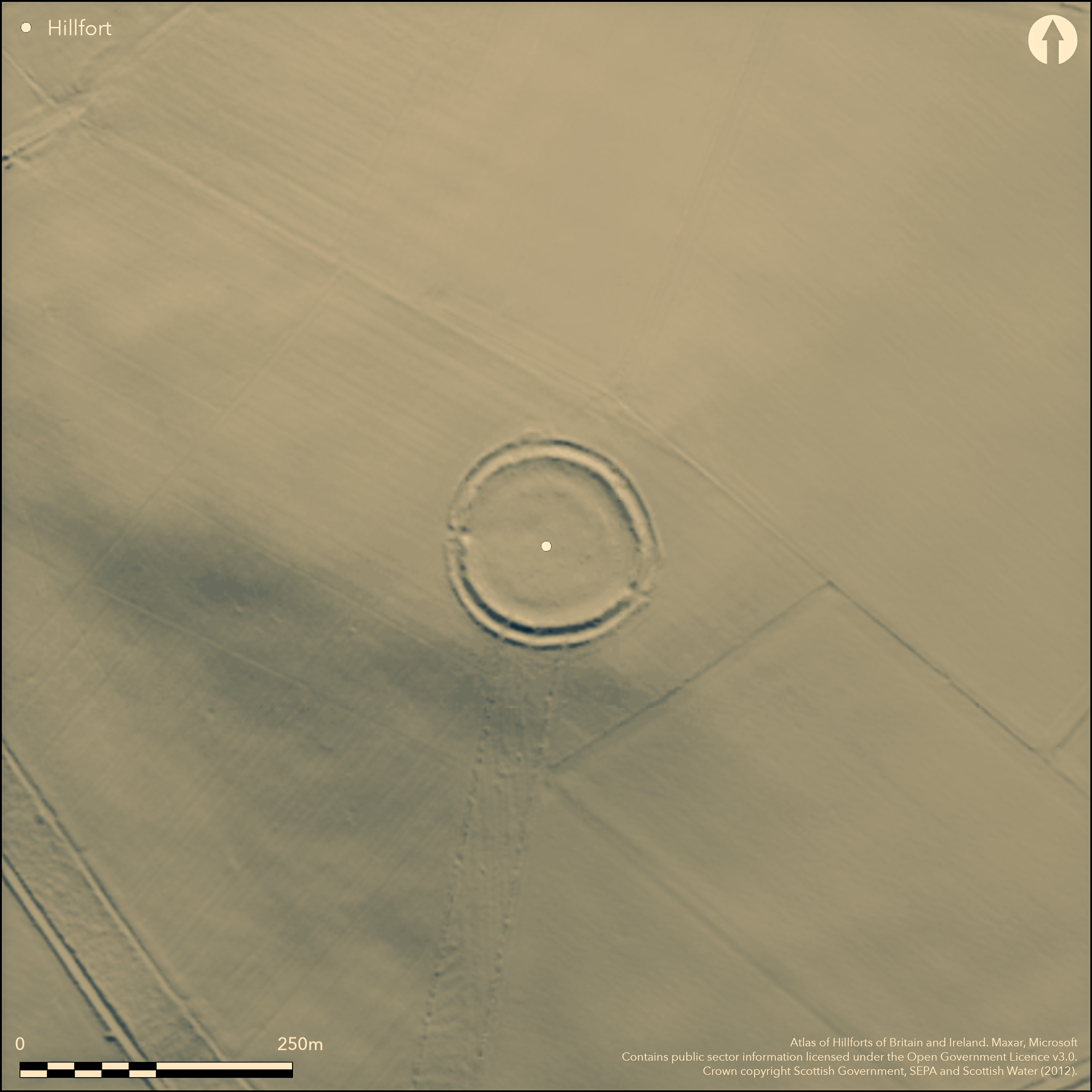
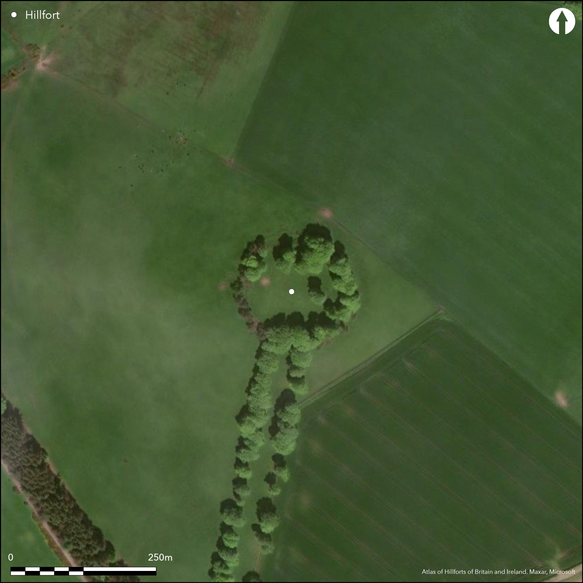
This circular fort is situated on the southern shoulder of the rounded summit of Chester Hill. It measures about 85m in diameter within twin ramparts with a medial ditch (0.55ha); the inner rampart is about 6m in thickness by 1.5m in height internally and its crest stands about 2.4m above the bottom of the ditch. There are entrances on the ESE and W, but the only feature visible within the interior is a shallow quarry scoop up to 10m broad lying immediately behind the inner rampart.
Citizen Science: ✗
Reliability of Data: Confirmed
Reliability of Interpretation: Confirmed
X: -407935 Y: 7486697 (EPSG: 3857)
Longitude: -3.6645457277338593 Latitude: 55.63805466198486 (EPSG:4326)
Country: Scotland
Current County or Unitary Authority: South Lanarkshire
Historic County: Lanarkshire
Current Parish/Community/Council/Townland: Covington And Thankerton
None
| Extant | ✓ |
| Cropmark | ✗ |
| Likely Destroyed | ✗ |
Ex plantation reduced to ring of trees and now grazed
| Woodland | ✓ |
| Commercial Forestry Plantation | ✗ |
| Parkland | ✗ |
| Pasture (Grazing) | ✓ |
| Arable | ✗ |
| Scrub/Bracken | ✗ |
| Bare Outcrop | ✗ |
| Heather/Moorland | ✗ |
| Heath | ✗ |
| Built-up | ✗ |
| Coastal Grassland | ✗ |
| Other | ✗ |
None
| Contour Fort | ✓ |
| Partial Contour Fort | ✗ |
| Promontory Fort | ✗ |
| Hillslope Fort | ✗ |
| Level Terrain Fort | ✗ |
| Marsh Fort | ✗ |
| Multiple Enclosure Fort | ✗ |
| Hilltop | ✓ |
| Coastal Promontory | ✗ |
| Inland Promontory | ✗ |
| Valley Bottom | ✗ |
| Knoll/Hillock/Outcrop | ✗ |
| Ridge | ✗ |
| Cliff/Plateau-edge/Scarp | ✗ |
| Hillslope | ✗ |
| Lowland | ✗ |
| Spur | ✗ |
Dominant Topographic Feature: None
| North | ✗ |
| Northeast | ✗ |
| East | ✗ |
| Southeast | ✗ |
| South | ✗ |
| Southwest | ✗ |
| West | ✗ |
| Northwest | ✗ |
| Level | ✓ |
Altitude: 305.0m
N/A
In the absence of excavation, there are neither stratified artefacts nor radiocarbon dates to provide a chronology for the defences.
Reliability: D - None
| Pre 1200BC | ✗ |
| 1200BC - 800BC | ✗ |
| 800BC - 400BC | ✗ |
| 400BC - AD50 | ✗ |
| AD50 - AD400 | ✗ |
| AD400 - AD 800 | ✗ |
| Post AD800 | ✗ |
| Unknown | ✓ |
| Pre Hillfort: | None |
| Post Hillfort: | Incorporated into Post medieval plantation |
First shown on William Roy's Military Survey of Scotland (1747-55), it is also depicted on William Forrest's map of The County of Lanark from an Actual Survey (1816), and shown in more detail in 1858 on the 1st edition OS 25-inch map (Lanarkshire 1864, sheet 33.6). Visited by George Irving about 1854 (Irving 1855, 26; Irving and Murray 1864, i, 24), it was sketch-planned by David Christison in 1889 (Christison 1890, 329-331, fig 26). RCAHMS visited in 1959 and again in 1963 during the preparation of the County Inventory for Lanarkshire and it was planned in 1976 (RCAHMS 1978, 97-8, no.224, fig 53). It was Scheduled in 1967 and visited by the OS in 1968. Geophysical survey was carried out (Lelong and Sharpe 1999) as part of a wider project around the Neolithic enclosure at Blackshouse Burn.
| 1st Identified Map Depiction (1755): | William Roy, Military Survey of Scotland (1747-55) |
| Other (1816): | William Forrest's map of The County of Lanark from an Actual Survey (1816) |
| Other (1858): | Annotated Roman Camp in Roman type on the 1st edition OS 25-inch map (Lanarkshire 1864, sheet 33.6) |
| Other (1864): | Description (Irving 1855, 26; Irving and Murray 1864, i, 24) |
| Earthwork Survey (1889): | Sketch-plan by David Christison (1890, 329-331, fig 26) |
| Other (1959): | Description during RCAHMS Survey of Marginal Lands |
| Other (1963): | Visited by RCAHMS (RCAHMS 1978, 97-8, no.224, fig 53) |
| Other (1967): | Scheduled |
| Other (1968): | Surveyed at 1:2500 by the OS |
| Earthwork Survey (1976): | Plan and description (RCAHMS 1978, 97-8, no.224, fig 53; RCAHMS LAD 133/1-2) |
| Geophysical Survey (1998): | Lelong and Sharpe 1999 (RCAHMS MS5100/23) |
Featureless apart from the internal quarry
None
| None | ✓ |
| Spring | ✗ |
| Stream | ✗ |
| Pool | ✗ |
| Flush | ✗ |
| Well | ✗ |
| Other | ✗ |
Old plantation and now improved pasture
| No Known Features | ✓ |
| Round Stone Structures | ✗ |
| Rectangular Stone Structures | ✗ |
| Curvilinear Platforms | ✗ |
| Other Roundhouse Evidence | ✗ |
| Pits | ✗ |
| Quarry Hollows | ✗ |
| Other | ✗ |
None
| No Known Excavation | ✓ |
| Pits | ✗ |
| Postholes | ✗ |
| Roundhouses | ✗ |
| Rectangular Structures | ✗ |
| Roads/Tracks | ✗ |
| Quarry Hollows | ✗ |
| Other | ✗ |
| Nothing Found | ✗ |
None
| No Known Geophysics | ✗ |
| Pits | ✗ |
| Roundhouses | ✗ |
| Rectangular Structures | ✗ |
| Roads/Tracks | ✗ |
| Quarry Hollows | ✓ |
| Other | ✗ |
| Nothing Found | ✗ |
None
| No Known Finds | ✓ |
| Pottery | ✗ |
| Metal | ✗ |
| Metalworking | ✗ |
| Human Bones | ✗ |
| Animal Bones | ✗ |
| Lithics | ✗ |
| Environmental | ✗ |
| Other | ✗ |
NO APPARENT FEATURES
| APs Not Checked | ✗ |
| None | ✓ |
| Roundhouses | ✗ |
| Rectangular Structures | ✗ |
| Pits | ✗ |
| Postholes | ✗ |
| Roads/Tracks | ✗ |
| Other | ✗ |
See main summary
| 2: | None |
| 2: | A third, blocked, is claimed from geophysics |
Guard Chambers: ✗
Chevaux de Frise: ✗
| 1. Simple Gap (South east): | None |
| 2. Blocked (South): | Claimed from geophysics (Lelong and Sharpe 1999) |
| 3. Simple Gap (West): | None |
Twin ramparts with a medial ditch
| Area 1: | 0.55ha. |
| Total: | 0.55ha. |
Total Footprint Area: 1.25ha.
None
| ✗ | None |
| ✓ | None |
| NE Quadrant: | 2 |
| SE Quadrant: | 2 |
| SW Quadrant: | 2 |
| NW Quadrant: | 2 |
| Total: | 2 |
| Partial Univallate | ✗ |
| Univallate | ✗ |
| Partial Bivallate | ✗ |
| Bivallate | ✓ |
| Partial Multivallate | ✗ |
| Multivallate | ✗ |
| Unknown | ✗ |
| Partial Univallate | ✗ |
| Univallate | ✗ |
| Partial Bivallate | ✗ |
| Bivallate | ✗ |
| Partial Multivallate | ✗ |
| Multivallate | ✗ |
None
| None | ✗ |
| Earthen Bank | ✓ |
| Stone Wall | ✗ |
| Rubble | ✗ |
| Wall-walk | ✗ |
| Evidence of Timber | ✗ |
| Vitrification | ✗ |
| Other Burning | ✗ |
| Palisade | ✗ |
| Counter Scarp Bank | ✗ |
| Berm | ✗ |
| Unfinished | ✗ |
| Other | ✗ |
None
| None | ✗ |
| Earthen Bank | ✗ |
| Stone Wall | ✗ |
| Murus Duplex | ✗ |
| Timber-framed | ✗ |
| Timber-laced | ✗ |
| Vitrification | ✗ |
| Other Burning | ✗ |
| Palisade | ✗ |
| Counter Scarp Bank | ✗ |
| Berm | ✗ |
| Unfinished | ✗ |
| No Known Excavation | ✓ |
| Other | ✗ |
| ✗ | None |
| ✓ | None |
Number of Ditches: 1
| ✗ | None |
Christison, D (1890) 'Forts, camps, and motes of the Upper Ward of Lanarkshire'. Proc Soc Antiq Scot 24 (1889-90), 281-352
Feachem, R (1963) A guide to prehistoric Scotland. Batsford: London (p 132)
Irving, G V (1855) 'On ancient camps of the upper ward of Lanarkshire', J Brit Archaeol Ass 10 (1855), 1-32
Irving and Murray, G V and A (1864) The upper ward of Lanarkshire described and delineated, 3v Glasgow
Lelong and Sharpe, O and L (1999) 'Blackhouse Burn environs (Chester Hill, Swaites Hill, Cairngryffe Hill) (Carmichael; Covington & Thankerton parishes), cairns; hut circles; enclosures', Disc Exc Scot 1999, 82
RCAHMS (1978) The Royal Commission on the Ancient and Historical Monuments of Scotland. Lanarkshire: an inventory of the prehistoric and Roman monuments. HMSO: Edinburgh
Atlas of Hillforts:
Wikidata:
This work is licensed under CC BY-SA 4.0![]()
![]()
![]() and should be cited as:
and should be cited as:
Lock, Gary and Ralston, Ian. 2024. Atlas of Hillforts of Britain and Ireland. Available at: https://hillforts.arch.ox.ac.uk
Document Version 1.1