
LiDAR 1m DTM Hillshade
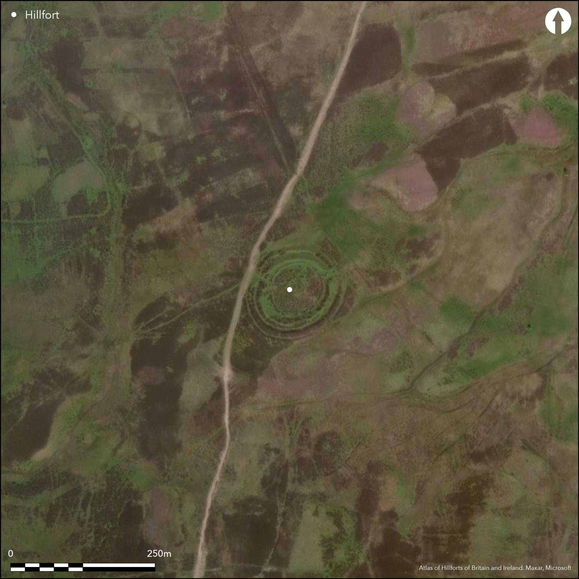
Satellite Imagery
LiDAR 1m DTM Hillshade
Satellite Imagery
Scroll left/right to view further images.
HER: The West of Scotland Archaeology Service 10594 (None)
NMR: NS 93 NE 6 (47509)
SM: 2610
NGR: NS 9619 3674
X: 296190 Y: 636740 (OSGB36)
This fort situated in the gently shelving moorland at the foot of the northern flank of the Tinto Hills is remarkably well-preserved, with a strong multivallate defence comprising two ramparts with external ditches, the outer of which is also accompanied around most of the circuit by a counterscarp bank. The inner rampart measures up to 12m in thickness by 2.8m in internal height, and appears to be capped by a stone wall some 3m in thickness. The interior, which measures 64m from NE to SW by 55m transversely (0.27ha), has evidently been utilised in the post-medieval period as a pound or fold and the greater part is enclosed by a low turf bank. At both of the entrances, on the ENE and WNW respectively, the two ramparts return and unite around the terminals of the ditches to form an entrance passage.
Citizen Science: ✗
Reliability of Data: Confirmed
Reliability of Interpretation: Confirmed
X: -406280 Y: 7481793 (EPSG: 3857)
Longitude: -3.6496778776547476 Latitude: 55.61318242981683 (EPSG:4326)
Country: Scotland
Current County or Unitary Authority: South Lanarkshire
Historic County: Lanarkshire
Current Parish/Community/Council/Townland: Covington And Thankerton
None
| Extant | ✓ |
| Cropmark | ✗ |
| Likely Destroyed | ✗ |
None
| Woodland | ✗ |
| Commercial Forestry Plantation | ✗ |
| Parkland | ✗ |
| Pasture (Grazing) | ✓ |
| Arable | ✗ |
| Scrub/Bracken | ✗ |
| Bare Outcrop | ✗ |
| Heather/Moorland | ✓ |
| Heath | ✗ |
| Built-up | ✗ |
| Coastal Grassland | ✗ |
| Other | ✗ |
A very gentle shelving slope, which is effectively level terrain.
| Contour Fort | ✗ |
| Partial Contour Fort | ✗ |
| Promontory Fort | ✗ |
| Hillslope Fort | ✗ |
| Level Terrain Fort | ✓ |
| Marsh Fort | ✗ |
| Multiple Enclosure Fort | ✗ |
| Hilltop | ✗ |
| Coastal Promontory | ✗ |
| Inland Promontory | ✗ |
| Valley Bottom | ✓ |
| Knoll/Hillock/Outcrop | ✗ |
| Ridge | ✗ |
| Cliff/Plateau-edge/Scarp | ✗ |
| Hillslope | ✗ |
| Lowland | ✗ |
| Spur | ✗ |
Dominant Topographic Feature: None
| North | ✗ |
| Northeast | ✗ |
| East | ✗ |
| Southeast | ✗ |
| South | ✗ |
| Southwest | ✗ |
| West | ✗ |
| Northwest | ✗ |
| Level | ✓ |
Altitude: 280.0m
N/A
In the absence of excavation, there are neither stratified artefacts nor radiocarbon dates to provide a chronology for the defences.
Reliability: D - None
| Pre 1200BC | ✗ |
| 1200BC - 800BC | ✗ |
| 800BC - 400BC | ✗ |
| 400BC - AD50 | ✗ |
| AD50 - AD400 | ✗ |
| AD400 - AD 800 | ✗ |
| Post AD800 | ✗ |
| Unknown | ✓ |
| Pre Hillfort: | None |
| Post Hillfort: | Interior utilised for a post-medieval fold |
Depicted on William Forrest's map of The County of Lanark from Actual Survey (1816), it is shown in fine detail on the 1st edition OS 25-inch map (Lanarkshire 1864, sheet 33.14). Noted by George Irving (Irving and Murray 1864, 24-5), the fort was sketch-planned by David Christison in 1889 (Christison 1890, 323-4, fig 22), and eventually surveyed by RCAHMS in 1959 and revisited in 1975 during the preparation of the County Inventory for Lanarkshire (RCAHMS 1978, 101-2, no.231, fig 58). It was Scheduled in 1967 and the OS surveyed the earthworks at 1:2500 in 1968. Photogenic from the air, it has been photographed under varying conditions by CUCAP and RCAHMS Aerial Survey Programme in 1972, 1975, 1977, 1981, 1991 and 2009.
| 1st Identified Map Depiction (1816): | William Forrest, The County of Lanark from Actual Survey (1816) |
| Other (1858): | Annotated Camp on the 1st edition OS 25-inch map (Lanarkshire 1864, sheet 33.14) |
| Other (1864): | Description by George Irving (Irving and Murray 1864, 24-5) |
| Earthwork Survey (1889): | Sketch-plan and description by David Christison (1890, 323-4, fig 22) |
| Earthwork Survey (1959): | Plan and description during RCAHMS Survey of Marginal Lands (RCAHMS 1978, 101-2, no.231, fig 58; RCAHMS LAD 139/1-2 & SC572992 |
| Other (1967): | Scheduled |
| Other (1968): | Surveyed at 1:2500 by the OS |
| Other (1975): | Plan and description reviewed (RCAHMS 1978, 101-2, no.231, fig 58) |
Featureless apart from a post-medieval turf-walled enclosure
None
| None | ✓ |
| Spring | ✗ |
| Stream | ✗ |
| Pool | ✗ |
| Flush | ✗ |
| Well | ✗ |
| Other | ✗ |
None
| No Known Features | ✓ |
| Round Stone Structures | ✗ |
| Rectangular Stone Structures | ✗ |
| Curvilinear Platforms | ✗ |
| Other Roundhouse Evidence | ✗ |
| Pits | ✗ |
| Quarry Hollows | ✗ |
| Other | ✗ |
None
| No Known Excavation | ✓ |
| Pits | ✗ |
| Postholes | ✗ |
| Roundhouses | ✗ |
| Rectangular Structures | ✗ |
| Roads/Tracks | ✗ |
| Quarry Hollows | ✗ |
| Other | ✗ |
| Nothing Found | ✗ |
None
| No Known Geophysics | ✓ |
| Pits | ✗ |
| Roundhouses | ✗ |
| Rectangular Structures | ✗ |
| Roads/Tracks | ✗ |
| Quarry Hollows | ✗ |
| Other | ✗ |
| Nothing Found | ✗ |
None
| No Known Finds | ✓ |
| Pottery | ✗ |
| Metal | ✗ |
| Metalworking | ✗ |
| Human Bones | ✗ |
| Animal Bones | ✗ |
| Lithics | ✗ |
| Environmental | ✗ |
| Other | ✗ |
NO APPARENT FEATURES
| APs Not Checked | ✗ |
| None | ✓ |
| Roundhouses | ✗ |
| Rectangular Structures | ✗ |
| Pits | ✗ |
| Postholes | ✗ |
| Roads/Tracks | ✗ |
| Other | ✗ |
See main summary
| 2: | None |
| 2: | None |
Guard Chambers: ✗
Chevaux de Frise: ✗
| 1. Passage-way/Corridor (North east): | None |
| 2. Passage-way/Corridor (North west): | None |
Twin ramparts and ditches with a counterscarp bank
| Area 1: | 0.27ha. |
| Total: | 0.27ha. |
Total Footprint Area: 0.78ha.
None
| ✗ | None |
| ✓ | None |
| NE Quadrant: | 2 |
| SE Quadrant: | 2 |
| SW Quadrant: | 2 |
| NW Quadrant: | 2 |
| Total: | 2 |
| Partial Univallate | ✗ |
| Univallate | ✗ |
| Partial Bivallate | ✗ |
| Bivallate | ✓ |
| Partial Multivallate | ✗ |
| Multivallate | ✗ |
| Unknown | ✗ |
| Partial Univallate | ✗ |
| Univallate | ✗ |
| Partial Bivallate | ✗ |
| Bivallate | ✗ |
| Partial Multivallate | ✗ |
| Multivallate | ✗ |
None
| None | ✗ |
| Earthen Bank | ✓ |
| Stone Wall | ✓ |
| Rubble | ✗ |
| Wall-walk | ✗ |
| Evidence of Timber | ✗ |
| Vitrification | ✗ |
| Other Burning | ✗ |
| Palisade | ✗ |
| Counter Scarp Bank | ✓ |
| Berm | ✗ |
| Unfinished | ✗ |
| Other | ✗ |
None
| None | ✗ |
| Earthen Bank | ✗ |
| Stone Wall | ✗ |
| Murus Duplex | ✗ |
| Timber-framed | ✗ |
| Timber-laced | ✗ |
| Vitrification | ✗ |
| Other Burning | ✗ |
| Palisade | ✗ |
| Counter Scarp Bank | ✗ |
| Berm | ✗ |
| Unfinished | ✗ |
| No Known Excavation | ✓ |
| Other | ✗ |
| ✗ | None |
| ✓ | None |
Number of Ditches: 2
| ✗ | None |
Christison, D (1890) 'Forts, camps, and motes of the Upper Ward of Lanarkshire'. Proc Soc Antiq Scot 24 (1889-90), 281-352
Irving and Murray, G V and A (1864) The upper ward of Lanarkshire described and delineated, 3v Glasgow
RCAHMS (1978) The Royal Commission on the Ancient and Historical Monuments of Scotland. Lanarkshire: an inventory of the prehistoric and Roman monuments. HMSO: Edinburgh
Atlas of Hillforts:
Wikidata:
This work is licensed under CC BY-SA 4.0![]()
![]()
![]() and should be cited as:
and should be cited as:
Lock, Gary and Ralston, Ian. 2024. Atlas of Hillforts of Britain and Ireland. Available at: https://hillforts.arch.ox.ac.uk
Document Version 1.1