LiDAR 1m DTM Hillshade
Satellite Imagery
LiDAR 1m DTM Hillshade
Satellite Imagery
Scroll left/right to view further images.
HER: The West of Scotland Archaeology Service 10612 (None)
NMR: NS 93 SE 11 (47527)
SM: None
NGR: NS 9981 3274
X: 299810 Y: 632740 (OSGB36)
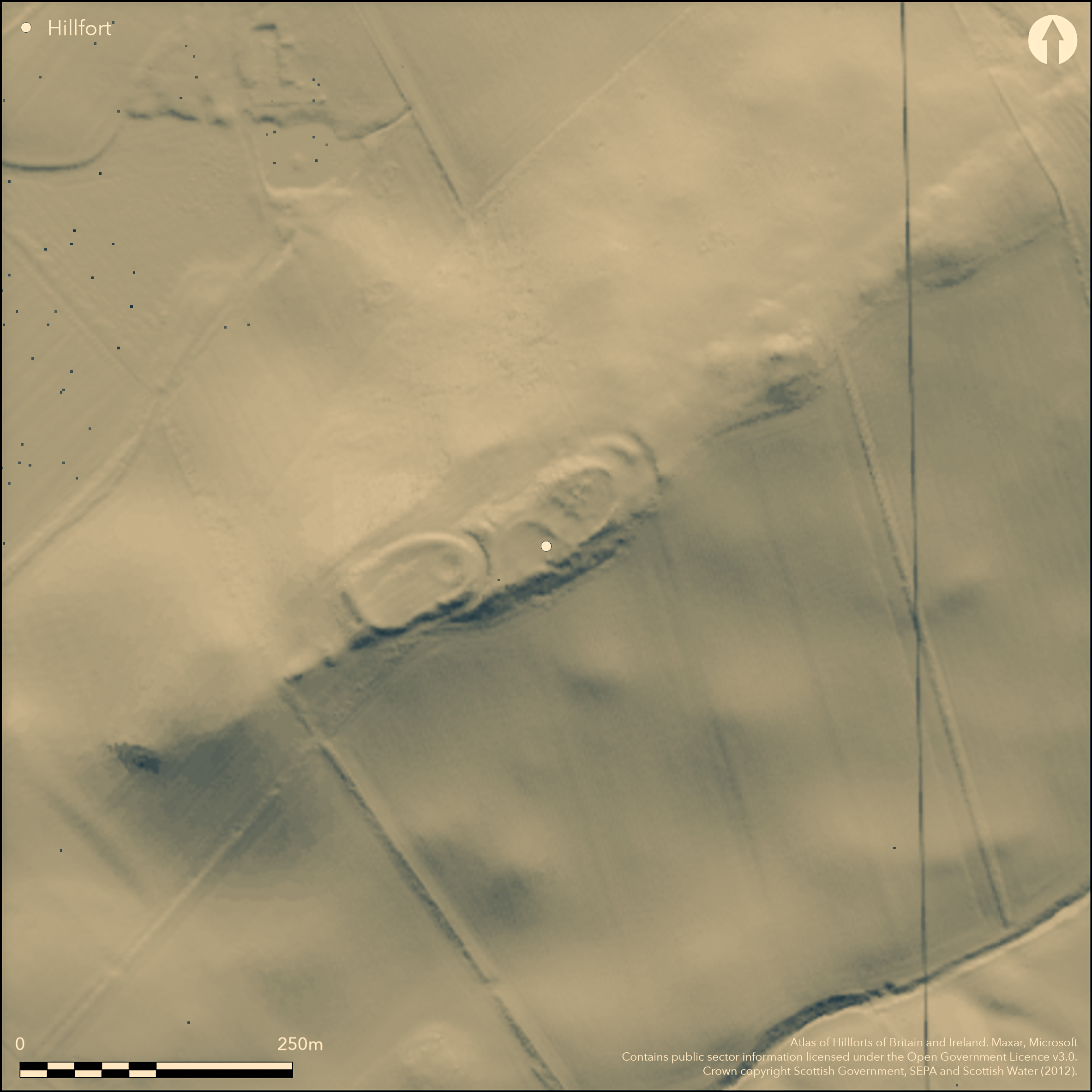
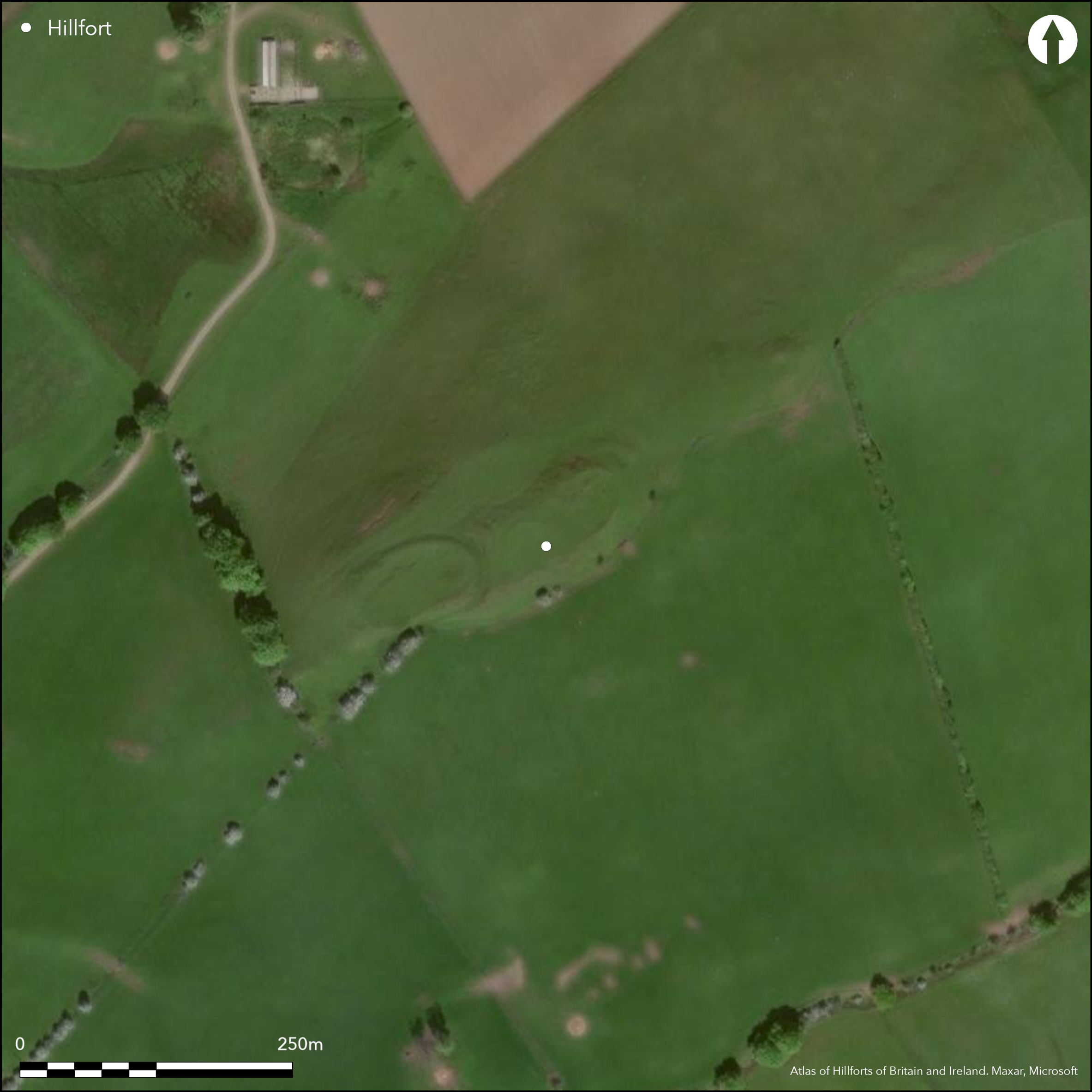
A group of earthworks on the SW tip of a ridge known as White Hill, probably includes an element of fortification, but they are heavily ploughed down and it is now difficult to assess their original character. Investigators of RCAHMS surveyed the earthworks in 1970 (RCAHMS 1978, 155-6, no.325, fig 103), and concluded that they represented at least three periods of construction, the earliest of which was an oval enclosure on the highest part of the ridge, measuring at least 75m from NE to SW by 27m transversely (0.2ha) within a rampart largely reduced to an external scarp; this is accompanied on the NE by an outlying rampart with a ditch up to 7.6m in breadth, which cuts across the spine of the ridge and returns for a short distance along its flanks. The SW end has been attenuated by the construction of an oval enclosure, whose perimeter at this point has comprised two ramparts with external ditches, though it is the inner ditch which is principally visible, measuring 8.5m in breadth by 1,3m in depth; the interior measures about 58m from NE to SW by 30m transversely (0.16ha). The RCAHMS investigators took the view that as the ditches appeared relatively broad and shallow these were not a defended enclosures, but in view of their ridge top position, the way they use the topography, and the reduction of the perimeters by cultivation, both these phases are evidently fortified. It is only in the third phase of construction, with the insertion of a small circular enclosure some 21m in internal diameter into the SW end of the earlier ridge-top fortification, that the occupation is evidently non-defensive.
Citizen Science: ✗
Reliability of Data: Confirmed
Reliability of Interpretation: Unconfirmed
X: -399723 Y: 7474865 (EPSG: 3857)
Longitude: -3.590776252671762 Latitude: 55.57801378686144 (EPSG:4326)
Country: Scotland
Current County or Unitary Authority: South Lanarkshire
Historic County: Lanarkshire
Current Parish/Community/Council/Townland: Lamington And Wandel
None
| Extant | ✓ |
| Cropmark | ✗ |
| Likely Destroyed | ✗ |
None
| Woodland | ✗ |
| Commercial Forestry Plantation | ✗ |
| Parkland | ✗ |
| Pasture (Grazing) | ✓ |
| Arable | ✓ |
| Scrub/Bracken | ✗ |
| Bare Outcrop | ✗ |
| Heather/Moorland | ✗ |
| Heath | ✗ |
| Built-up | ✗ |
| Coastal Grassland | ✗ |
| Other | ✗ |
None
| Contour Fort | ✓ |
| Partial Contour Fort | ✗ |
| Promontory Fort | ✗ |
| Hillslope Fort | ✗ |
| Level Terrain Fort | ✗ |
| Marsh Fort | ✗ |
| Multiple Enclosure Fort | ✗ |
| Hilltop | ✓ |
| Coastal Promontory | ✗ |
| Inland Promontory | ✗ |
| Valley Bottom | ✗ |
| Knoll/Hillock/Outcrop | ✗ |
| Ridge | ✗ |
| Cliff/Plateau-edge/Scarp | ✗ |
| Hillslope | ✗ |
| Lowland | ✗ |
| Spur | ✓ |
Dominant Topographic Feature: None
| North | ✗ |
| Northeast | ✗ |
| East | ✗ |
| Southeast | ✗ |
| South | ✗ |
| Southwest | ✗ |
| West | ✗ |
| Northwest | ✗ |
| Level | ✓ |
Altitude: 250.0m
N/A
In the absence of excavation, there are neither stratified artefacts nor radiocarbon dates to provide a chronology for the defences.
Reliability: D - None
| Pre 1200BC | ✗ |
| 1200BC - 800BC | ✗ |
| 800BC - 400BC | ✗ |
| 400BC - AD50 | ✗ |
| AD50 - AD400 | ✗ |
| AD400 - AD 800 | ✗ |
| Post AD800 | ✗ |
| Unknown | ✓ |
| Pre Hillfort: | None |
| Post Hillfort: | Overlain by what is probably a small undefended Iron Age settlement enclosure |
Noted in the Statistical Account (Stat Acct 6, 1793, 557n) and in the New Statistical Account (NSA, 6, Lanrkshire, 817), and depicted on William Forrest's map of The county of Lanark from Actual Survey (1816), it is shown in more detail on the 1st edition OS 25-inch map (Lanarkshire 1864, sheets 39.8 & 39.12). The earthworks were sketch-planned by David Christison in 1889 (Christison 1890, 308-9, fig 10), and eventually visited by RCAHMS in 1963 during the preparation of the County Inventory for Lanarkshire and subsequently planned in 1970 and revisited in 1975 (RCAHMS 1978, 155-6, no.325, fig 103). They were photographed from the air by CUCAP in 1967, 1969 and 1974. The OS visited in 1955 and resurveyed at 1:2500 in 1979.
| 1st Identified Written Reference (1793): | Noted (Stat Acct 6, 1793, 557n) |
| 1st Identified Map Depiction (1816): | William Forrest, The county of Lanark from Actual Survey (1816) |
| Other (1859): | Annotated Camp on the 1st edition OS 25-inch map (Lanarkshire 1864, sheets 39.8 & 39.12) |
| Earthwork Survey (1889): | Sketch-plan and description by David Christison (1890, 308-9, fig 10) |
| Other (1955): | Visited by the OS |
| Other (1963): | Description by RCAHMS |
| Earthwork Survey (1970): | Plan (RCAHMS 1978, 155-6, no.325, fig 103; RCAHMS LAD 170/1-2) |
| Other (1975): | Plan and description reviewed (RCAHMS 1978, 155-6, no.325, fig 103) |
| Other (1979): | Resurveyed at 1:2500 by the OS |
Featureless apart from the small circular enclosure
None
| None | ✓ |
| Spring | ✗ |
| Stream | ✗ |
| Pool | ✗ |
| Flush | ✗ |
| Well | ✗ |
| Other | ✗ |
Small probably Late Iron Age settlement enclosure
| No Known Features | ✗ |
| Round Stone Structures | ✗ |
| Rectangular Stone Structures | ✗ |
| Curvilinear Platforms | ✗ |
| Other Roundhouse Evidence | ✗ |
| Pits | ✗ |
| Quarry Hollows | ✗ |
| Other | ✓ |
None
| No Known Excavation | ✓ |
| Pits | ✗ |
| Postholes | ✗ |
| Roundhouses | ✗ |
| Rectangular Structures | ✗ |
| Roads/Tracks | ✗ |
| Quarry Hollows | ✗ |
| Other | ✗ |
| Nothing Found | ✗ |
None
| No Known Geophysics | ✓ |
| Pits | ✗ |
| Roundhouses | ✗ |
| Rectangular Structures | ✗ |
| Roads/Tracks | ✗ |
| Quarry Hollows | ✗ |
| Other | ✗ |
| Nothing Found | ✗ |
None
| No Known Finds | ✓ |
| Pottery | ✗ |
| Metal | ✗ |
| Metalworking | ✗ |
| Human Bones | ✗ |
| Animal Bones | ✗ |
| Lithics | ✗ |
| Environmental | ✗ |
| Other | ✗ |
Small probably Late Iron Age settlement enclosure
| APs Not Checked | ✗ |
| None | ✗ |
| Roundhouses | ✗ |
| Rectangular Structures | ✗ |
| Pits | ✗ |
| Postholes | ✗ |
| Roads/Tracks | ✗ |
| Other | ✓ |
None known
| 0: | Heavily degraded all round the circuit |
| 2: | None identified |
Guard Chambers: ✗
Chevaux de Frise: ✗
There are essentially two successive fortifications, the larger of which is tabulated here
| Area 1: | 0.2ha. |
| Total: | 0.2ha. |
Total Footprint Area: 0.5ha.
None
| ✓ | None |
| ✓ | Defences obscured on the SW by the construction of the second fortification |
| NE Quadrant: | 2 |
| SE Quadrant: | 1 |
| SW Quadrant: | 0 |
| NW Quadrant: | 1 |
| Total: | 2 |
| Partial Univallate | ✓ |
| Univallate | ✗ |
| Partial Bivallate | ✓ |
| Bivallate | ✗ |
| Partial Multivallate | ✗ |
| Multivallate | ✗ |
| Unknown | ✗ |
| Partial Univallate | ✗ |
| Univallate | ✗ |
| Partial Bivallate | ✗ |
| Bivallate | ✗ |
| Partial Multivallate | ✗ |
| Multivallate | ✗ |
None
| None | ✗ |
| Earthen Bank | ✓ |
| Stone Wall | ✗ |
| Rubble | ✗ |
| Wall-walk | ✗ |
| Evidence of Timber | ✗ |
| Vitrification | ✗ |
| Other Burning | ✗ |
| Palisade | ✗ |
| Counter Scarp Bank | ✗ |
| Berm | ✗ |
| Unfinished | ✗ |
| Other | ✗ |
None
| None | ✗ |
| Earthen Bank | ✗ |
| Stone Wall | ✗ |
| Murus Duplex | ✗ |
| Timber-framed | ✗ |
| Timber-laced | ✗ |
| Vitrification | ✗ |
| Other Burning | ✗ |
| Palisade | ✗ |
| Counter Scarp Bank | ✗ |
| Berm | ✗ |
| Unfinished | ✗ |
| No Known Excavation | ✓ |
| Other | ✗ |
| ✗ | None |
| ✓ | None |
Number of Ditches: 1
| ✗ | The outwork on the NE is 10m in advance of the inner rampart, but this may be an elaboration of the depth of defences at an otherwise unidentified entrance rather than an annexe. |
Christison, D (1890) 'Forts, camps, and motes of the Upper Ward of Lanarkshire'. Proc Soc Antiq Scot 24 (1889-90), 281-352
RCAHMS (1978) The Royal Commission on the Ancient and Historical Monuments of Scotland. Lanarkshire: an inventory of the prehistoric and Roman monuments. HMSO: Edinburgh
Atlas of Hillforts:
Wikidata:
This work is licensed under CC BY-SA 4.0![]()
![]()
![]() and should be cited as:
and should be cited as:
Lock, Gary and Ralston, Ian. 2024. Atlas of Hillforts of Britain and Ireland. Available at: https://hillforts.arch.ox.ac.uk
Document Version 1.1