LiDAR 1m DTM Hillshade
Satellite Imagery
LiDAR 1m DTM Hillshade
Satellite Imagery
Scroll left/right to view further images.
HER: The West of Scotland Archaeology Service 10771 (None)
NMR: NS 94 SW 11 (47688)
SM: None
NGR: NS 9429 4116
X: 294290 Y: 641160 (OSGB36)
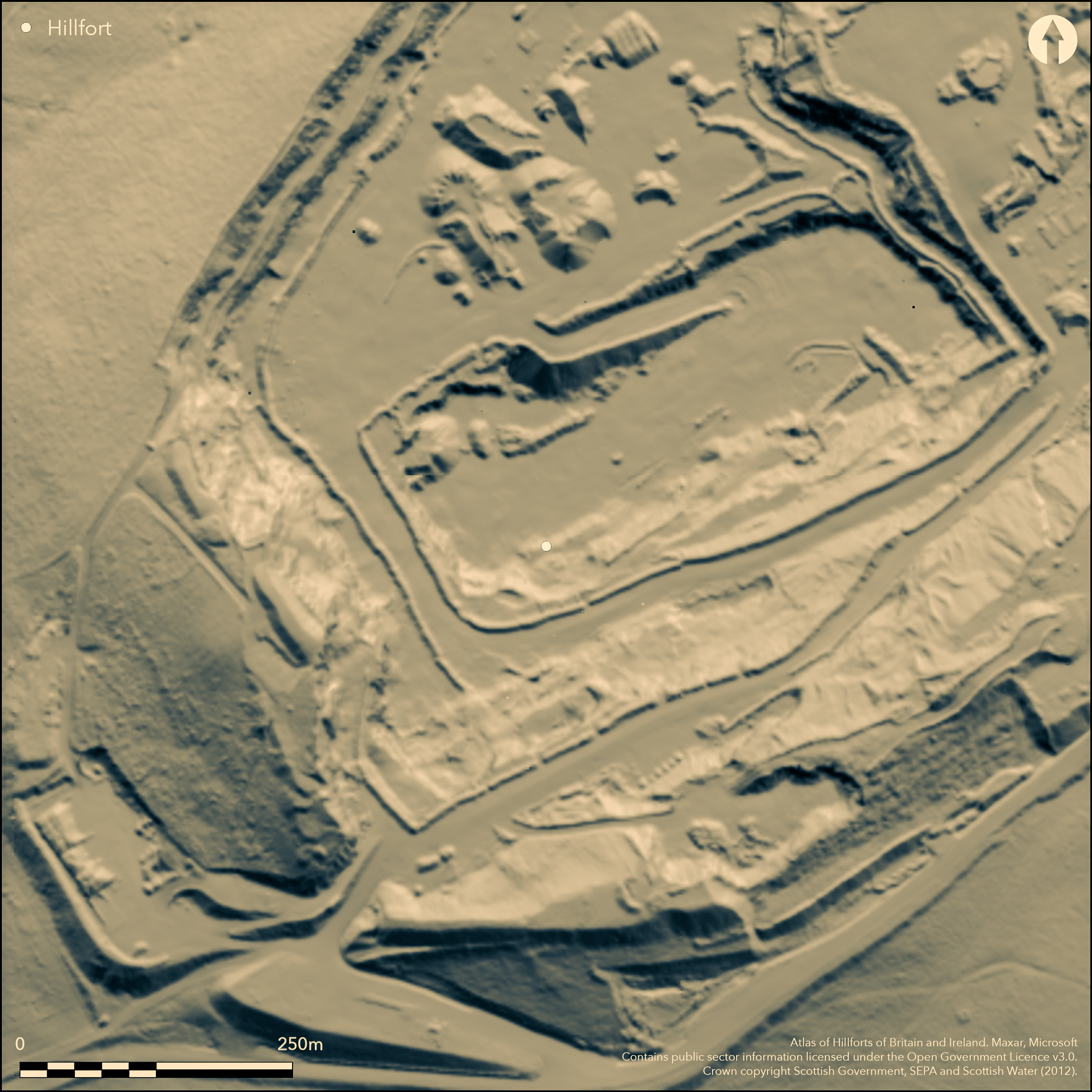
The remains of a small fortification that once occupied the summit of Cairngryffe Hill was excavated in 1939 by Professor Gordon Childe (Childe 1941). The defences comprised two elements, namely a small inner walled enclosure, and an outer rampart, and probably represented two separate phases of construction. The inner enclosure was oval on plan and measured 22m from N to S by 20m transversely (0.04) within a wall at least 3m thick, with parts of its faces still standing up to 0.9m in height in five courses; the entrance was on the S. The outer rampart enclosed an area measuring 47m from N to S by 41m transversely (0.15ha) and comprised little more than a low bank of rubble about 3m in thickness, with an external kerb of upright slabs, many of which had fallen outwards and boulders. While Childe considered that this cannot have formed a substantial barrier, it may have been robbed to build the inner enclosure. Its entrance was also on the S, but had already been destroyed by the time of the excavation. Apart from a row of post-holes immediately to the rear of the inner wall on the ENE, and a possible drain extending beneath the wall on the SSE, no traces of any internal structures were uncovered. Apart from part of a stone ring found in the drain, quarrymen recovered; a Donside terret; a bronze object, possibly a lynch-pin; a hemispherical lead object; and a cannel coal ring.
Citizen Science: ✗
Reliability of Data: Confirmed
Reliability of Interpretation: Confirmed
X: -409826 Y: 7489541 (EPSG: 3857)
Longitude: -3.681528169771013 Latitude: 55.65247152098294 (EPSG:4326)
Country: Scotland
Current County or Unitary Authority: South Lanarkshire
Historic County: Lanarkshire
Current Parish/Community/Council/Townland: Pettinain
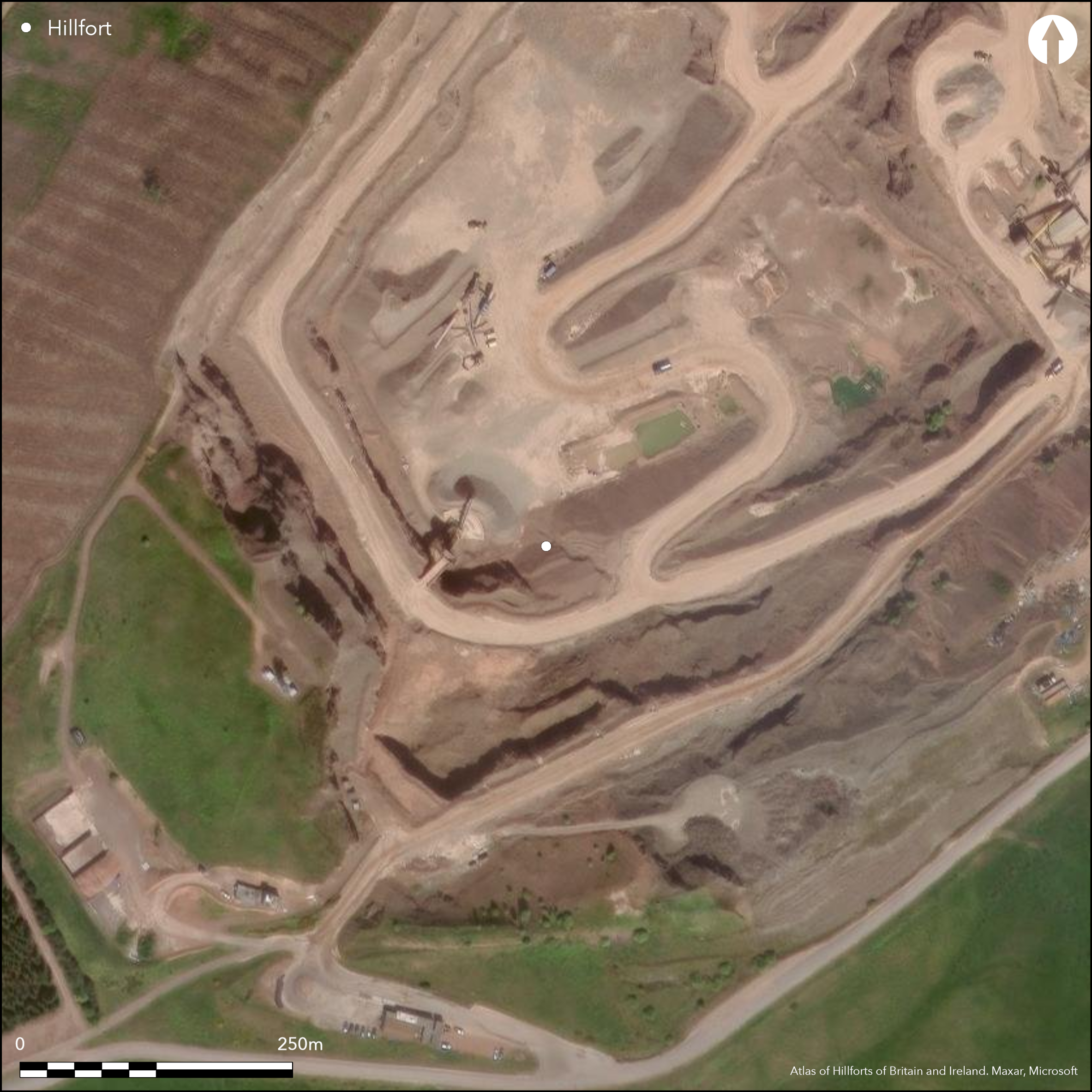
Quarried
Condition:| Extant | ✗ |
| Cropmark | ✗ |
| Likely Destroyed | ✓ |
Quarry
Current Use:| Woodland | ✗ |
| Commercial Forestry Plantation | ✗ |
| Parkland | ✗ |
| Pasture (Grazing) | ✗ |
| Arable | ✗ |
| Scrub/Bracken | ✗ |
| Bare Outcrop | ✗ |
| Heather/Moorland | ✗ |
| Heath | ✗ |
| Built-up | ✗ |
| Coastal Grassland | ✗ |
| Other | ✓ |
None
Type:| Contour Fort | ✓ |
| Partial Contour Fort | ✗ |
| Promontory Fort | ✗ |
| Hillslope Fort | ✗ |
| Level Terrain Fort | ✗ |
| Marsh Fort | ✗ |
| Multiple Enclosure Fort | ✗ |
| Hilltop | ✓ |
| Coastal Promontory | ✗ |
| Inland Promontory | ✗ |
| Valley Bottom | ✗ |
| Knoll/Hillock/Outcrop | ✗ |
| Ridge | ✗ |
| Cliff/Plateau-edge/Scarp | ✗ |
| Hillslope | ✗ |
| Lowland | ✗ |
| Spur | ✗ |
Dominant Topographic Feature: None
| North | ✗ |
| Northeast | ✗ |
| East | ✗ |
| Southeast | ✗ |
| South | ✗ |
| Southwest | ✗ |
| West | ✗ |
| Northwest | ✗ |
| Level | ✓ |
Altitude: 340.0m
N/A
Unstratified finds recovered by quarry men include a Donside terret
Reliability: D - None
Principal Activity:| Pre 1200BC | ✗ |
| 1200BC - 800BC | ✗ |
| 800BC - 400BC | ✗ |
| 400BC - AD50 | ✗ |
| AD50 - AD400 | ✓ |
| AD400 - AD 800 | ✗ |
| Post AD800 | ✗ |
| Unknown | ✓ |
| Pre Hillfort: | None |
| Post Hillfort: | Construction of the inner stone-walled enclosure |
| Artefactual: | None |
First depicted on William Forrest's map of The County of Lanark from Actual Survey (1816), about 1854 it was sketch-planned by George Irving (Irving 1855, 25, pl 2 fig 20) and appears as three concentric lines in 1858 on the 1st edition OS 25-inch map (Lanarkshire 1864, sheet 33.1). Irving considered the inner ring to be a sheepfold, as did David Christison, who prepared his own sketch in 1889 (Christison 1890 325-6, fig 23-4). A Scheduled monument, in 1939 Gordon Childe supervised excavations at the fort at the behest of the Ministry of Works prior to its destruction by quarrying (Childe 1941). A summary of the excavation report is contained within the County Inventory for Lanarkshire (RCAHMS 1978, 95-6, no.220, fig 50)
| 1st Identified Map Depiction (1816): | William Forrest, The County of Lanark from Actual Survey (1816) |
| Earthwork Survey (1854): | Sketch-plan and description (Irving 1855, 25, Pl 2 fig 20) |
| Other (1858): | Annotated Camp on the 1st edition OS 25-inch map (Lanarkshire 1864, sheet 33.1) |
| Earthwork Survey (1889): | Sketch-plan and description by David Christison (1890 325-6, fig 23-4) |
| Other (1939): | Scheduled prior to 1939 |
| Excavation (1939): | Childe 1941 |
Featureless apart from the inner stone-walled enclosure
None
Source:| None | ✓ |
| Spring | ✗ |
| Stream | ✗ |
| Pool | ✗ |
| Flush | ✗ |
| Well | ✗ |
| Other | ✗ |
None
Interior Features (Surface):| No Known Features | ✓ |
| Round Stone Structures | ✗ |
| Rectangular Stone Structures | ✗ |
| Curvilinear Platforms | ✗ |
| Other Roundhouse Evidence | ✗ |
| Pits | ✗ |
| Quarry Hollows | ✗ |
| Other | ✗ |
A drain
Interior Features (Excavation):| No Known Excavation | ✗ |
| Pits | ✗ |
| Postholes | ✓ |
| Roundhouses | ✗ |
| Rectangular Structures | ✗ |
| Roads/Tracks | ✗ |
| Quarry Hollows | ✗ |
| Other | ✓ |
| Nothing Found | ✗ |
None
Interior Features (Geophysics):| No Known Geophysics | ✓ |
| Pits | ✗ |
| Roundhouses | ✗ |
| Rectangular Structures | ✗ |
| Roads/Tracks | ✗ |
| Quarry Hollows | ✗ |
| Other | ✗ |
| Nothing Found | ✗ |
Finds from quarrying include: a Donside terret; a bronze object, possibly a lynch-pin; a hemispherical lead object; a cannel coal ring; a stone ring; and a quartz disc
Interior (Finds):| No Known Finds | ✗ |
| Pottery | ✗ |
| Metal | ✓ |
| Metalworking | ✗ |
| Human Bones | ✗ |
| Animal Bones | ✗ |
| Lithics | ✓ |
| Environmental | ✗ |
| Other | ✗ |
NO APPARENT FEATURES
Interior Features (Aerial):| APs Not Checked | ✓ |
| None | ✗ |
| Roundhouses | ✗ |
| Rectangular Structures | ✗ |
| Pits | ✗ |
| Postholes | ✗ |
| Roads/Tracks | ✗ |
| Other | ✗ |
See main summary
Total Number of Breaks Through Ramparts:| 1: | None |
| 2: | Entrance into the inner enclosure was on the S, and probably in the outer too |
Guard Chambers: ✗
Chevaux de Frise: ✗
| 1. Simple Gap (South): | None |
Inner and outer walls, but probably representing two periods of construction, of which the outer is here treated as the fort.
Enclosed Area:| Area 1: | 0.15ha. |
| Total: | 0.15ha. |
Total Footprint Area: Noneha.
None
Multi-period Enclosure System:| ✓ | None |
| ✓ | Inner wall is excluded |
| NE Quadrant: | 1 |
| SE Quadrant: | 1 |
| SW Quadrant: | 1 |
| NW Quadrant: | 1 |
| Total: | 1 |
| Partial Univallate | ✗ |
| Univallate | ✓ |
| Partial Bivallate | ✗ |
| Bivallate | ✗ |
| Partial Multivallate | ✗ |
| Multivallate | ✗ |
| Unknown | ✗ |
| Partial Univallate | ✗ |
| Univallate | ✓ |
| Partial Bivallate | ✗ |
| Bivallate | ✗ |
| Partial Multivallate | ✗ |
| Multivallate | ✗ |
Visible as rubble banks before destruction
Enclosing Works (Surface):| None | ✓ |
| Earthen Bank | ✗ |
| Stone Wall | ✗ |
| Rubble | ✓ |
| Wall-walk | ✗ |
| Evidence of Timber | ✗ |
| Vitrification | ✗ |
| Other Burning | ✗ |
| Palisade | ✗ |
| Counter Scarp Bank | ✗ |
| Berm | ✗ |
| Unfinished | ✗ |
| Other | ✗ |
None
Enclosing Works (Excavation):| None | ✗ |
| Earthen Bank | ✗ |
| Stone Wall | ✓ |
| Murus Duplex | ✗ |
| Timber-framed | ✗ |
| Timber-laced | ✗ |
| Vitrification | ✗ |
| Other Burning | ✗ |
| Palisade | ✗ |
| Counter Scarp Bank | ✗ |
| Berm | ✗ |
| Unfinished | ✗ |
| No Known Excavation | ✗ |
| Other | ✗ |
| ✗ | None |
| ✗ | None |
Number of Ditches: None
Annex:| ✗ | None |
Childe, V G (1941) 'Examination of the prehistoric fort on Cairngryfe Hill, near Lanark', Proc Soc Antiq Scot 75 (1940-41), 213-18
Christison, D (1890) 'Forts, camps, and motes of the Upper Ward of Lanarkshire'. Proc Soc Antiq Scot 24 (1889-90), 281-352
Irving, G V (1855) 'On ancient camps of the upper ward of Lanarkshire', J Brit Archaeol Ass 10 (1855), 1-32
RCAHMS (1978) The Royal Commission on the Ancient and Historical Monuments of Scotland. Lanarkshire: an inventory of the prehistoric and Roman monuments. HMSO: Edinburgh
This work is licensed under CC BY-SA 4.0![]()
![]()
![]() and should be cited as:
and should be cited as:
Lock, Gary and Ralston, Ian. 2024. Atlas of Hillforts of Britain and Ireland. Available at: https://hillforts.arch.ox.ac.uk
Document Version 1.1