
LiDAR 1m DTM Hillshade
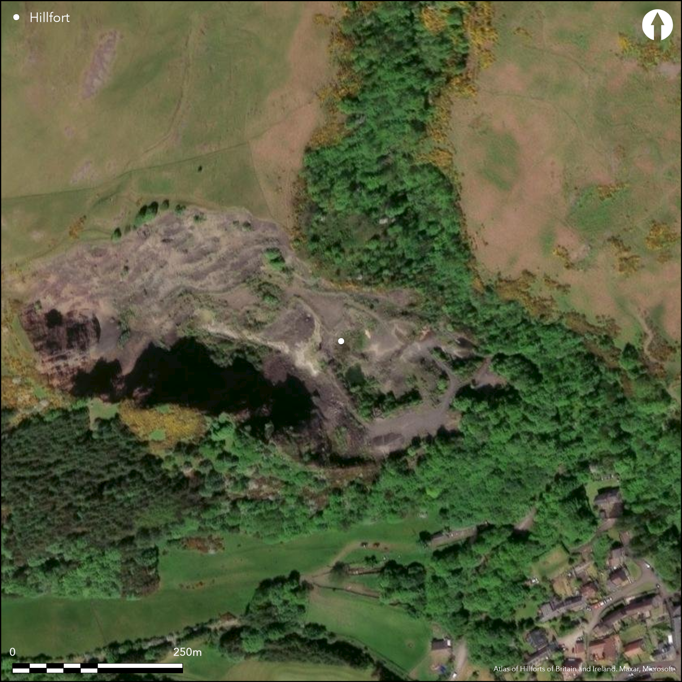
Satellite Imagery
LiDAR 1m DTM Hillshade
Satellite Imagery
Scroll left/right to view further images.
HER: Stirling 1382 (None)
NMR: NS 99 NW 5 (48294)
SM: None
NGR: NS 9116 9769
X: 291160 Y: 697690 (OSGB36)
This small fortification occupied a low spur projecting from the SE flank of the hill on the W side of the mouth of the glen above Tillicoultry. Unfortunately it has been completely removed by Tillicoultry Quarry, but a plan drawn up by RCAHMS in 1952 shows that its defences comprised two elements: an inner stone walled enclosure; and an outer rampart with an external rock-cut ditch, which were drawn across the neck of the spur to isolate it from the rest of the hill. The inner enclosure was circular on plan, measuring 25m in diameter (0.05ha) within a wall 3.6m in thickness, and a gap in the wall on the SW possibly marked the position of the entrance. The inner face of the wall, still standing up to four courses high, was visible around the western half of the circuit, and a short section of the outer face on the NW. A watching brief was maintained during the demolition and a mechanical shovel was used to uncover a length of the outer face around the E side, revealing that it was built of massive blocks with small pinnings, which were also used to keep the lowest course roughly horizontal (Cruden 1964, 57). While the outer defences across the neck of the spur may have been no more than an outwork protecting the easiest line of approach to the inner enclosure, they might equally represent the remain of an earlier fort in its own right, effectively blocking access to a steep-sided promontory. The rampart had been reduced to a stony bank about 2m in thickness, but the ditch was an impressive feature up to 3.6m in depth, in places with vertical rock-cut sides at the bottom between 0.7m and 1.5m high; there were also remains of an external bank of upcast on the flanks of the spur. The area cut off measured 85m from NE to SW, by at least 85m transversely (0.5ha) at the time that the plan was drawn up, but by then the SE tip of the spur had already been removed. There may have been an entrance between the western end of these defences and the SW margin of the spur. Sherds of what is possibly coarse Roman pottery from 'Tillicoultry Craig' in the National Museum of Antiquities of Scotland (Robertson 1970, 225) possibly come from here, the only other 'Craig' placename nearby being Wester and Easter Kirk Craigs high up above the village on the opposite side of the glen
Citizen Science: ✗
Reliability of Data: Confirmed
Reliability of Interpretation: Confirmed
X: -417895 Y: 7590227 (EPSG: 3857)
Longitude: -3.7540161828089427 Latitude: 56.15946722324707 (EPSG:4326)
Country: Scotland
Current County or Unitary Authority: Clackmannan
Historic County: Clackmannanshire
Current Parish/Community/Council/Townland: Tillicoultry
None
| Extant | ✗ |
| Cropmark | ✗ |
| Likely Destroyed | ✓ |
Quarry; previously Moorland and outcrop
| Woodland | ✗ |
| Commercial Forestry Plantation | ✗ |
| Parkland | ✗ |
| Pasture (Grazing) | ✗ |
| Arable | ✗ |
| Scrub/Bracken | ✗ |
| Bare Outcrop | ✗ |
| Heather/Moorland | ✗ |
| Heath | ✗ |
| Built-up | ✗ |
| Coastal Grassland | ✗ |
| Other | ✓ |
None
| Contour Fort | ✗ |
| Partial Contour Fort | ✗ |
| Promontory Fort | ✓ |
| Hillslope Fort | ✗ |
| Level Terrain Fort | ✗ |
| Marsh Fort | ✗ |
| Multiple Enclosure Fort | ✗ |
| Hilltop | ✗ |
| Coastal Promontory | ✗ |
| Inland Promontory | ✓ |
| Valley Bottom | ✗ |
| Knoll/Hillock/Outcrop | ✗ |
| Ridge | ✗ |
| Cliff/Plateau-edge/Scarp | ✗ |
| Hillslope | ✗ |
| Lowland | ✗ |
| Spur | ✗ |
Dominant Topographic Feature: None
| North | ✗ |
| Northeast | ✗ |
| East | ✗ |
| Southeast | ✗ |
| South | ✗ |
| Southwest | ✗ |
| West | ✗ |
| Northwest | ✗ |
| Level | ✓ |
Altitude: 160.0m
N/A
Sherds of possible coarse Roman pottery may have come from here, but in the absence of excavation, there are neither stratified artefacts nor radiocarbon dates to provide a chronology for the defences..
Reliability: B - Medium
| Pre 1200BC | ✗ |
| 1200BC - 800BC | ✗ |
| 800BC - 400BC | ✗ |
| 400BC - AD50 | ✓ |
| AD50 - AD400 | ✓ |
| AD400 - AD 800 | ✗ |
| Post AD800 | ✓ |
| Unknown | ✗ |
| Pre Hillfort: | None |
| Post Hillfort: | None |
Despite being noted in the Statistical Account (Stat Acct xv, 1795, 214), and described by Christian Maclagan, though her claim that the defences comprised three concentric walls should not be taken too literally (Maclagan 1875, 56), it does not appear on any of the early editions of the OS maps. RCAHMS investigators visited in 1932 during the preparation of the County Inventory for Clackmannanshire (RCAHMS 1933, 326-7, no.618), and it was subsequently planned in 1952 during the Survey of Marginal Lands. The OS visited in 1953, when the quarry was already impinging on the spur and it was demolished in 1964; by the time of a second visit by the OS in 1974 the whole area had been removed.
| 1st Identified Written Reference (1795): | Noted (Stat Acct xv, 1795, 214) |
| Other (1875): | Description by Christian Maclagan (1875, 56) |
| Other (1932): | Description (RCAHMS 1933, 326-7, no.618) |
| Earthwork Survey (1952): | Plan and description during RCAHMS Survey of Marginal Lands (RCAHMS CLD 25/1-3) |
| Other (1953): | Visited by the OS |
| Other (1974): | Visited by the OS, who found the whole site removed |
Featureless apart from the inner enclosure
None
| None | ✓ |
| Spring | ✗ |
| Stream | ✗ |
| Pool | ✗ |
| Flush | ✗ |
| Well | ✗ |
| Other | ✗ |
Inner enclosure
| No Known Features | ✗ |
| Round Stone Structures | ✗ |
| Rectangular Stone Structures | ✗ |
| Curvilinear Platforms | ✗ |
| Other Roundhouse Evidence | ✗ |
| Pits | ✗ |
| Quarry Hollows | ✗ |
| Other | ✓ |
None
| No Known Excavation | ✓ |
| Pits | ✗ |
| Postholes | ✗ |
| Roundhouses | ✗ |
| Rectangular Structures | ✗ |
| Roads/Tracks | ✗ |
| Quarry Hollows | ✗ |
| Other | ✗ |
| Nothing Found | ✗ |
None
| No Known Geophysics | ✓ |
| Pits | ✗ |
| Roundhouses | ✗ |
| Rectangular Structures | ✗ |
| Roads/Tracks | ✗ |
| Quarry Hollows | ✗ |
| Other | ✗ |
| Nothing Found | ✗ |
Sherds of possible coarse Roman pottery from Tillicoultry Craig may have come from here.
| No Known Finds | ✗ |
| Pottery | ✓ |
| Metal | ✗ |
| Metalworking | ✗ |
| Human Bones | ✗ |
| Animal Bones | ✗ |
| Lithics | ✗ |
| Environmental | ✗ |
| Other | ✗ |
Destroyed
| APs Not Checked | ✓ |
| None | ✗ |
| Roundhouses | ✗ |
| Rectangular Structures | ✗ |
| Pits | ✗ |
| Postholes | ✗ |
| Roads/Tracks | ✗ |
| Other | ✗ |
See main summary
| 1: | None |
| 2: | None |
Guard Chambers: ✗
Chevaux de Frise: ✗
| 1. Simple Gap (South west): | rampart and ditch peter out short of the margin of the promontory |
Fort comprises a rampart and ditch drawn across the neck
| Area 1: | 0.5ha. |
| Total: | 0.5ha. |
Total Footprint Area: Noneha.
None
| ✗ | None |
| ✗ | Omits the inner enclosure |
| NE Quadrant: | 1 |
| SE Quadrant: | 0 |
| SW Quadrant: | 0 |
| NW Quadrant: | 1 |
| Total: | 1 |
| Partial Univallate | ✓ |
| Univallate | ✗ |
| Partial Bivallate | ✗ |
| Bivallate | ✗ |
| Partial Multivallate | ✗ |
| Multivallate | ✗ |
| Unknown | ✗ |
| Partial Univallate | ✗ |
| Univallate | ✗ |
| Partial Bivallate | ✗ |
| Bivallate | ✗ |
| Partial Multivallate | ✗ |
| Multivallate | ✗ |
Now destroyed and nothin visible
| None | ✓ |
| Earthen Bank | ✗ |
| Stone Wall | ✗ |
| Rubble | ✓ |
| Wall-walk | ✗ |
| Evidence of Timber | ✗ |
| Vitrification | ✗ |
| Other Burning | ✗ |
| Palisade | ✗ |
| Counter Scarp Bank | ✓ |
| Berm | ✗ |
| Unfinished | ✗ |
| Other | ✗ |
None
| None | ✗ |
| Earthen Bank | ✗ |
| Stone Wall | ✗ |
| Murus Duplex | ✗ |
| Timber-framed | ✗ |
| Timber-laced | ✗ |
| Vitrification | ✗ |
| Other Burning | ✗ |
| Palisade | ✗ |
| Counter Scarp Bank | ✗ |
| Berm | ✗ |
| Unfinished | ✗ |
| No Known Excavation | ✓ |
| Other | ✗ |
| ✗ | None |
| ✓ | None |
Number of Ditches: 1
| ✗ | None |
Cruden, S H (1964) 'Castle craig, Tillicoultry, Fife'. Disc Exc Scot 1964, 57
Feachem, R (1963) A guide to prehistoric Scotland. Batsford: London
Maclagan, C (1875) The hill forts, stone circles and other structural remains of ancient Scotland, Edinburgh
RCAHMS (1933) The Royal Commission on the Ancient and Historical Monuments and Constructions of Scotland. Eleventh report with inventory of monuments and constructions in the counties of Fife, Kinross, and Clackmannan. HMSO: Edinburgh
Robertson, A S (1970) 'Roman finds from non-Roman sites in Scotland', Britannia 1 (1970)
Atlas of Hillforts:
Wikidata:
This work is licensed under CC BY-SA 4.0![]()
![]()
![]() and should be cited as:
and should be cited as:
Lock, Gary and Ralston, Ian. 2024. Atlas of Hillforts of Britain and Ireland. Available at: https://hillforts.arch.ox.ac.uk
Document Version 1.1