Satellite Imagery
Satellite Imagery
HER: The West of Scotland Archaeology Service 1903 (None)
NMR: NR 24 SE 3 (37290)
SM: 13271
NGR: NR 2849 4070
X: 128490 Y: 640700 (OSGB36)
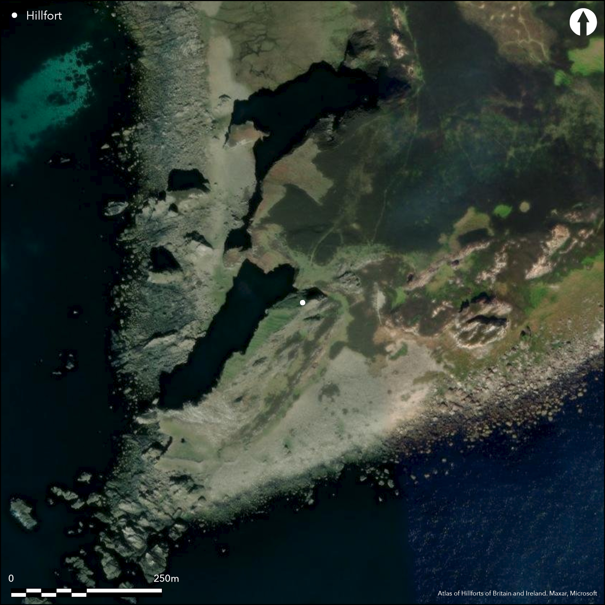
One of the most spectacular promontory works in Scotland, Dun Athad is a narrow finger of land, which projects SW from the cliffs of the Oa and drops away almost sheer along both sides to the foreshore 105m below. The defences comprise a single thick wall 17.8m in length commanding the slope that drops into a narrow coll on the landward side; a well defined outer face can be traced, returning at either end, and though the line of the inner face is unknown the rubble core is spread about 5.8m in thickness, extending up to the rear wall of a large rectangular building set roughly E and W across the top of the promontory; in the course of a visit by the HFSG a piece of vitrified stone was identified in the wall core. The entrance was probably between the terminal of the wall and the NW margin of the promontory, where the modern path gains access to the roughly level interior on the top of the promontory. This measures about 90m from NE to SW by between 6m and 23m transversely (0.1ha), and while there are traces of structures at the NE end, it is mostly covered with cultivation rigs.
Citizen Science: ✗
Reliability of Data: Confirmed
Reliability of Interpretation: Confirmed
X: -702449 Y: 7476058 (EPSG: 3857)
Longitude: -6.3102054132145255 Latitude: 55.58407117791461 (EPSG:4326)
Country: Scotland
Current County or Unitary Authority: Argyll & Bute
Historic County: Argyll
Current Parish/Community/Council/Townland: Kildalton And Oa
None
| Extant | ✓ |
| Cropmark | ✗ |
| Likely Destroyed | ✗ |
None
| Woodland | ✗ |
| Commercial Forestry Plantation | ✗ |
| Parkland | ✗ |
| Pasture (Grazing) | ✓ |
| Arable | ✗ |
| Scrub/Bracken | ✗ |
| Bare Outcrop | ✗ |
| Heather/Moorland | ✗ |
| Heath | ✗ |
| Built-up | ✗ |
| Coastal Grassland | ✓ |
| Other | ✗ |
None
| Contour Fort | ✗ |
| Partial Contour Fort | ✗ |
| Promontory Fort | ✓ |
| Hillslope Fort | ✗ |
| Level Terrain Fort | ✗ |
| Marsh Fort | ✗ |
| Multiple Enclosure Fort | ✗ |
| Hilltop | ✗ |
| Coastal Promontory | ✓ |
| Inland Promontory | ✗ |
| Valley Bottom | ✗ |
| Knoll/Hillock/Outcrop | ✗ |
| Ridge | ✗ |
| Cliff/Plateau-edge/Scarp | ✗ |
| Hillslope | ✗ |
| Lowland | ✗ |
| Spur | ✗ |
Dominant Topographic Feature: None
| North | ✗ |
| Northeast | ✗ |
| East | ✗ |
| Southeast | ✗ |
| South | ✗ |
| Southwest | ✗ |
| West | ✗ |
| Northwest | ✗ |
| Level | ✓ |
Altitude: 105.0m
N/A
In the absence of excavation, there are neither stratified artefacts nor radiocarbon dates to provide a chronology for the defences.
Reliability: D - None
| Pre 1200BC | ✗ |
| 1200BC - 800BC | ✗ |
| 800BC - 400BC | ✗ |
| 400BC - AD50 | ✗ |
| AD50 - AD400 | ✗ |
| AD400 - AD 800 | ✗ |
| Post AD800 | ✓ |
| Unknown | ✓ |
| Pre Hillfort: | None |
| Post Hillfort: | Conventional dating of this fortification places it in the post-medieval period, but the qualities of the site make it likely that it was fortified in earlier periods. |
Possibly the 'great fortress called Dunaynt' in a topographical account preserved in Walter Macfarlanes Geographical Collections (1906, ii, 189), Dun Athad was named in Gothic type on the 1st edition OS 25-inch map (Argyll and Bute 1878, 239.10). It was visited by the Islay Survey Group about 1959 (Lamont 1959) and surveyed by RCAHMS in 1978 during the preparation of the County Inventory for Argyll (RCAHMS 1984, 264-5, no.401). It was Scheduled in 2013. It has been photographed from the air by CUCAP in 1975 and RCAHMS in 1983, 2005 and 2011.
| 1st Identified Map Depiction (1878): | Named in Gothic type on the 1st edition OS 25-inch map (Argyll and Bute 1878, 239.10) |
| Other (1959): | visited by the Islay Survey Group (Lamont 1959) |
| Earthwork Survey (1978): | Description and plan (RCAHMS 1984, 264-5, no.401; RCAHMS AGD 557/1; SC427395) |
| Other (2007): | Visited by the Hill-Fort Study Group |
| Other (2013): | Scheduled |
Rectangular building and traces of several other structures behind the wall and rig elsewhere
None
| None | ✓ |
| Spring | ✗ |
| Stream | ✗ |
| Pool | ✗ |
| Flush | ✗ |
| Well | ✗ |
| Other | ✗ |
None
| No Known Features | ✗ |
| Round Stone Structures | ✗ |
| Rectangular Stone Structures | ✓ |
| Curvilinear Platforms | ✗ |
| Other Roundhouse Evidence | ✗ |
| Pits | ✗ |
| Quarry Hollows | ✗ |
| Other | ✗ |
None
| No Known Excavation | ✓ |
| Pits | ✗ |
| Postholes | ✗ |
| Roundhouses | ✗ |
| Rectangular Structures | ✗ |
| Roads/Tracks | ✗ |
| Quarry Hollows | ✗ |
| Other | ✗ |
| Nothing Found | ✗ |
None
| No Known Geophysics | ✓ |
| Pits | ✗ |
| Roundhouses | ✗ |
| Rectangular Structures | ✗ |
| Roads/Tracks | ✗ |
| Quarry Hollows | ✗ |
| Other | ✗ |
| Nothing Found | ✗ |
None
| No Known Finds | ✓ |
| Pottery | ✗ |
| Metal | ✗ |
| Metalworking | ✗ |
| Human Bones | ✗ |
| Animal Bones | ✗ |
| Lithics | ✗ |
| Environmental | ✗ |
| Other | ✗ |
None
| APs Not Checked | ✗ |
| None | ✗ |
| Roundhouses | ✗ |
| Rectangular Structures | ✓ |
| Pits | ✗ |
| Postholes | ✗ |
| Roads/Tracks | ✗ |
| Other | ✗ |
See main summary
| 0: | None |
| 2: | Position on the NW only inferred by the topography |
Guard Chambers: ✗
Chevaux de Frise: ✗
Single wall across promontory
| Area 1: | 0.1ha. |
| Total: | 0.1ha. |
Total Footprint Area: Noneha.
None
| ✗ | None |
| ✗ | None |
| NE Quadrant: | 1 |
| SE Quadrant: | 0 |
| SW Quadrant: | 0 |
| NW Quadrant: | 0 |
| Total: | 1 |
| Partial Univallate | ✓ |
| Univallate | ✗ |
| Partial Bivallate | ✗ |
| Bivallate | ✗ |
| Partial Multivallate | ✗ |
| Multivallate | ✗ |
| Unknown | ✗ |
| Partial Univallate | ✗ |
| Univallate | ✗ |
| Partial Bivallate | ✗ |
| Bivallate | ✗ |
| Partial Multivallate | ✗ |
| Multivallate | ✗ |
Single piece of vitrified stone found
| None | ✗ |
| Earthen Bank | ✗ |
| Stone Wall | ✓ |
| Rubble | ✗ |
| Wall-walk | ✗ |
| Evidence of Timber | ✗ |
| Vitrification | ✓ |
| Other Burning | ✗ |
| Palisade | ✗ |
| Counter Scarp Bank | ✗ |
| Berm | ✗ |
| Unfinished | ✗ |
| Other | ✗ |
None
| None | ✗ |
| Earthen Bank | ✗ |
| Stone Wall | ✗ |
| Murus Duplex | ✗ |
| Timber-framed | ✗ |
| Timber-laced | ✗ |
| Vitrification | ✗ |
| Other Burning | ✗ |
| Palisade | ✗ |
| Counter Scarp Bank | ✗ |
| Berm | ✗ |
| Unfinished | ✗ |
| No Known Excavation | ✓ |
| Other | ✗ |
| ✗ | None |
| ✗ | None |
Number of Ditches: None
| ✗ | None |
Lamont, W (1959) 'From the Islay Archaeological Survey Group', Disc Exc Scot 1959, 154
Macfarlane, W 1906 Geographical Collections Relating to Scotland, 1-3 (Mitchell, A ed), Edinburgh
RCAHMS (1984) The Royal Commission on the Ancient and Historical Monuments of Scotland. Argyll: an inventory of the monuments volume 5: Islay, Jura, Colonsay and Oronsay. HMSO: Edinburgh
Atlas of Hillforts:
Wikidata:
This work is licensed under CC BY-SA 4.0![]()
![]()
![]() and should be cited as:
and should be cited as:
Lock, Gary and Ralston, Ian. 2024. Atlas of Hillforts of Britain and Ireland. Available at: https://hillforts.arch.ox.ac.uk
Document Version 1.1