LiDAR 1m DTM Hillshade
Satellite Imagery
LiDAR 1m DTM Hillshade
Satellite Imagery
Scroll left/right to view further images.
HER: The West of Scotland Archaeology Service 3399 (None)
NMR: NR 72 SW 25 (38807)
SM: 3096
NGR: NR 7302 2222
X: 173020 Y: 622220 (OSGB36)
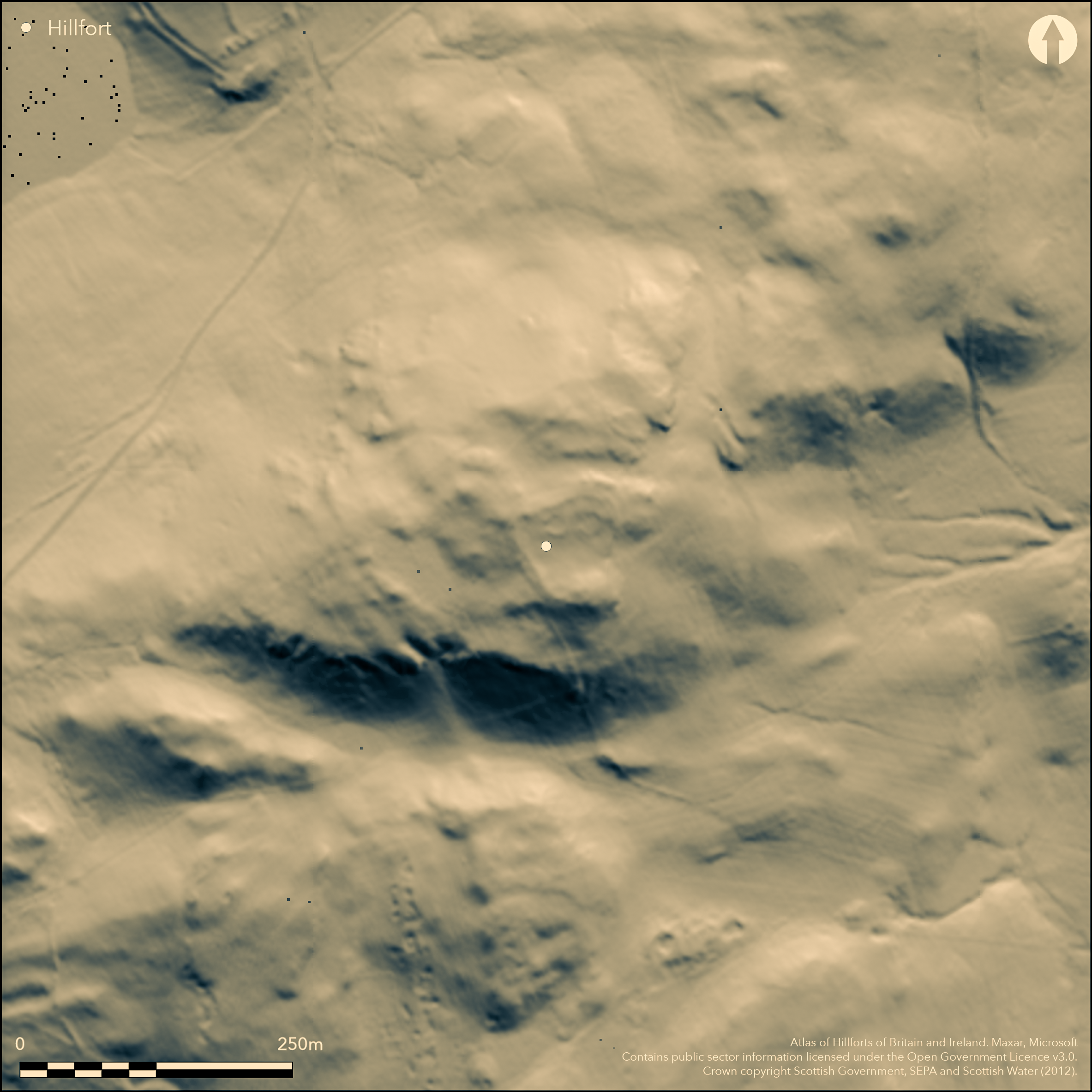
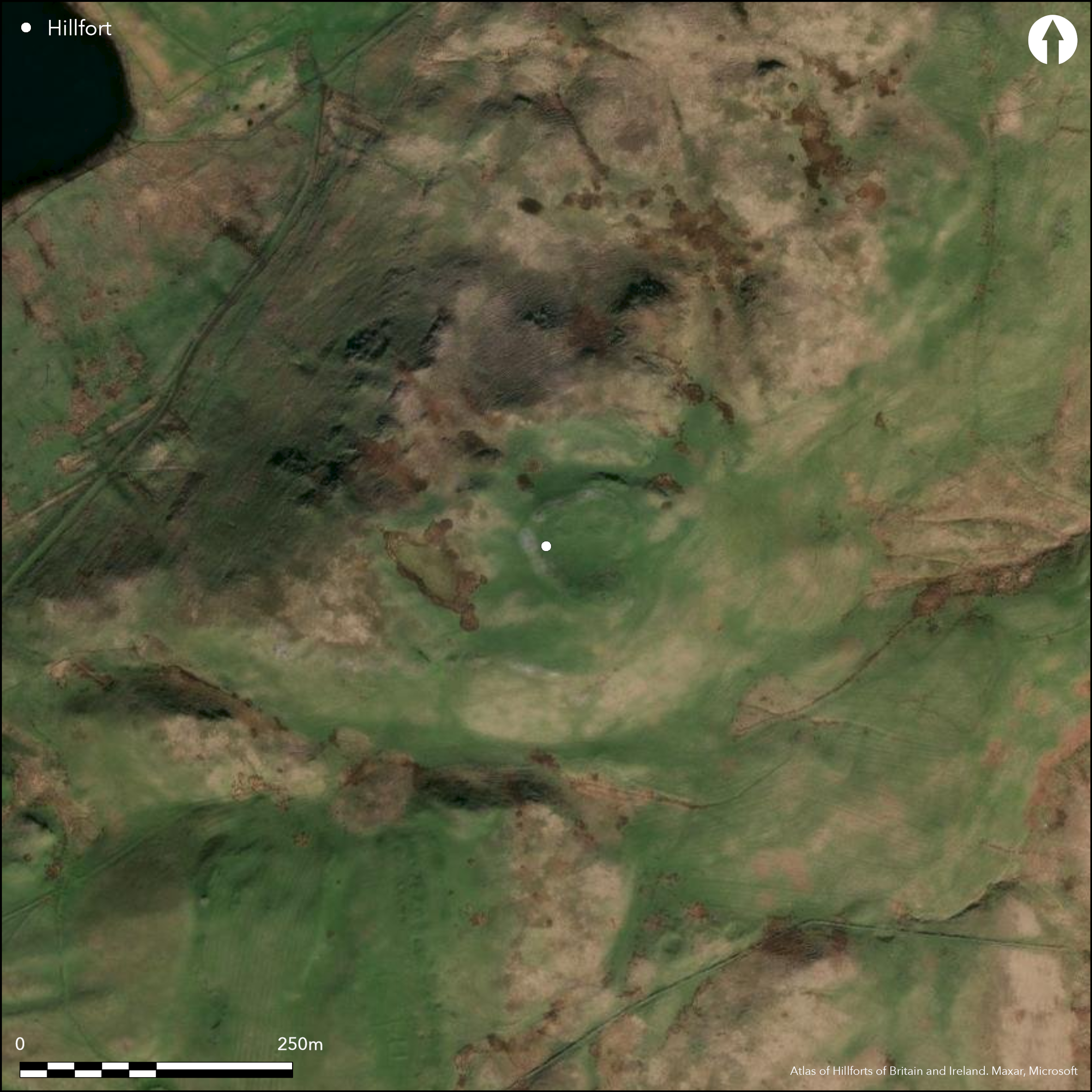
This fort encloses the summit of Knock Scalbart from which the ground falls away steeply on the S and SE. Roughly pear-shaped on plan, it measures 55m from NNW to SSE by a maximum of 49m transversely within a ruinous wall up to 4.6m in thickness, though it seems to reduce to less than 3m on the less easily accessible SE flank. The entrance is on the WSW, comprising an outer passage some 1.5m wide and 2.4m long, which broadens to 2.1m to the rear of door checks on either side; a gap in the wall on the E is probably secondary. Within the N half of the interior there are two probable round-houses, the better defined measuring about 8.5m in diameter within a low bank broken by an entrance on the W, while on the S there is also a small rock-cut platform beside a mound surmounted by the OS triangulation pillar. Later activity has also seen the construction of two small pens, one butting against the wall on the E, and the other within its thickness on the NE.
Citizen Science: ✗
Reliability of Data: Confirmed
Reliability of Interpretation: Confirmed
X: -622290 Y: 7447956 (EPSG: 3857)
Longitude: -5.590127676344007 Latitude: 55.44113147905383 (EPSG:4326)
Country: Scotland
Current County or Unitary Authority: Argyll & Bute
Historic County: Argyll
Current Parish/Community/Council/Townland: Campbeltown
None
| Extant | ✓ |
| Cropmark | ✗ |
| Likely Destroyed | ✗ |
None
| Woodland | ✗ |
| Commercial Forestry Plantation | ✗ |
| Parkland | ✗ |
| Pasture (Grazing) | ✓ |
| Arable | ✗ |
| Scrub/Bracken | ✗ |
| Bare Outcrop | ✗ |
| Heather/Moorland | ✓ |
| Heath | ✗ |
| Built-up | ✗ |
| Coastal Grassland | ✗ |
| Other | ✗ |
None
| Contour Fort | ✓ |
| Partial Contour Fort | ✗ |
| Promontory Fort | ✗ |
| Hillslope Fort | ✗ |
| Level Terrain Fort | ✗ |
| Marsh Fort | ✗ |
| Multiple Enclosure Fort | ✗ |
| Hilltop | ✓ |
| Coastal Promontory | ✗ |
| Inland Promontory | ✗ |
| Valley Bottom | ✗ |
| Knoll/Hillock/Outcrop | ✗ |
| Ridge | ✗ |
| Cliff/Plateau-edge/Scarp | ✗ |
| Hillslope | ✗ |
| Lowland | ✗ |
| Spur | ✗ |
Dominant Topographic Feature: None
| North | ✗ |
| Northeast | ✗ |
| East | ✗ |
| Southeast | ✗ |
| South | ✗ |
| Southwest | ✗ |
| West | ✗ |
| Northwest | ✗ |
| Level | ✓ |
Altitude: 215.0m
N/A
In the absence of excavation, there are neither stratified artefacts nor radiocarbon dates to provide a chronology for the defences.
Reliability: D - None
| Pre 1200BC | ✗ |
| 1200BC - 800BC | ✗ |
| 800BC - 400BC | ✗ |
| 400BC - AD50 | ✗ |
| AD50 - AD400 | ✗ |
| AD400 - AD 800 | ✗ |
| Post AD800 | ✗ |
| Unknown | ✓ |
| Pre Hillfort: | The mound beneath the OS triangulation pillar is possibly the remains of an earlier Bronze Age cairn. A polished stone axe was found within the interior (Saville 2002). |
| Post Hillfort: | None |
First depicted in 1866 on the 1st edition OS 25-inch map (Argyll and Bute 1869, sheet 257.4), it was visited by RCAHMS in 1955 during the Survey of Marginal Lands and planned in 1960 during the preparation of the County Inventory for Argyll (RCAHMS 1971, 72-3, no.170). It was Scheduled in 1971. The OS visited in 1977 and in 2001 a Neolithic polished stone axe was picked up in the interior (Saville 2002). The fort was photographed from the air by RCAHMS in 2008.
| 1st Identified Map Depiction (1866): | Annotated Fort on the 1st edition OS 25-inch map (Argyll and Bute 1869, sheet 257.4) |
| Other (1955): | Description during RCAHMS Survey of Marginal Lands |
| Earthwork Survey (1960): | Plan and description (RCAHMS 1971, 72-3, no.170; RCAHMS AGD 294/1-2) |
| Other (1971): | Scheduled |
| Other (1977): | Surveyed at 1:10.000 by the OS |
Two probable round-houses
None
| None | ✓ |
| Spring | ✗ |
| Stream | ✗ |
| Pool | ✗ |
| Flush | ✗ |
| Well | ✗ |
| Other | ✗ |
None
| No Known Features | ✗ |
| Round Stone Structures | ✓ |
| Rectangular Stone Structures | ✗ |
| Curvilinear Platforms | ✗ |
| Other Roundhouse Evidence | ✗ |
| Pits | ✗ |
| Quarry Hollows | ✗ |
| Other | ✗ |
None
| No Known Excavation | ✓ |
| Pits | ✗ |
| Postholes | ✗ |
| Roundhouses | ✗ |
| Rectangular Structures | ✗ |
| Roads/Tracks | ✗ |
| Quarry Hollows | ✗ |
| Other | ✗ |
| Nothing Found | ✗ |
None
| No Known Geophysics | ✓ |
| Pits | ✗ |
| Roundhouses | ✗ |
| Rectangular Structures | ✗ |
| Roads/Tracks | ✗ |
| Quarry Hollows | ✗ |
| Other | ✗ |
| Nothing Found | ✗ |
Neolithic polished stone axe
| No Known Finds | ✗ |
| Pottery | ✗ |
| Metal | ✗ |
| Metalworking | ✗ |
| Human Bones | ✗ |
| Animal Bones | ✗ |
| Lithics | ✓ |
| Environmental | ✗ |
| Other | ✗ |
NO APPARENT FEATURES
| APs Not Checked | ✗ |
| None | ✗ |
| Roundhouses | ✓ |
| Rectangular Structures | ✗ |
| Pits | ✗ |
| Postholes | ✗ |
| Roads/Tracks | ✗ |
| Other | ✗ |
See main summary
| 3: | sector of wall on the SE almost removed and a secondary gap on the E |
| 2: | None |
Guard Chambers: ✗
Chevaux de Frise: ✗
| 1. Passage-way/Corridor (West): | None |
Single ruinous wall
| Area 1: | 0.19ha. |
| Total: | 0.19ha. |
Total Footprint Area: 0.25ha.
None
| ✗ | None |
| ✓ | None |
| NE Quadrant: | 1 |
| SE Quadrant: | 1 |
| SW Quadrant: | 1 |
| NW Quadrant: | 1 |
| Total: | 1 |
| Partial Univallate | ✗ |
| Univallate | ✓ |
| Partial Bivallate | ✗ |
| Bivallate | ✗ |
| Partial Multivallate | ✗ |
| Multivallate | ✗ |
| Unknown | ✗ |
| Partial Univallate | ✗ |
| Univallate | ✗ |
| Partial Bivallate | ✗ |
| Bivallate | ✗ |
| Partial Multivallate | ✗ |
| Multivallate | ✗ |
None
| None | ✗ |
| Earthen Bank | ✗ |
| Stone Wall | ✓ |
| Rubble | ✗ |
| Wall-walk | ✗ |
| Evidence of Timber | ✗ |
| Vitrification | ✗ |
| Other Burning | ✗ |
| Palisade | ✗ |
| Counter Scarp Bank | ✗ |
| Berm | ✗ |
| Unfinished | ✗ |
| Other | ✗ |
None
| None | ✗ |
| Earthen Bank | ✗ |
| Stone Wall | ✗ |
| Murus Duplex | ✗ |
| Timber-framed | ✗ |
| Timber-laced | ✗ |
| Vitrification | ✗ |
| Other Burning | ✗ |
| Palisade | ✗ |
| Counter Scarp Bank | ✗ |
| Berm | ✗ |
| Unfinished | ✗ |
| No Known Excavation | ✓ |
| Other | ✗ |
| ✗ | None |
| ✗ | None |
Number of Ditches: None
| ✗ | None |
Harding, D W (1997) 'Forts, duns, brochs and crannogs: Iron Age settlements in Argyll', in Ritchie, G The archaeology of Argyll, Edinburgh (p 120)
RCAHMS (1971) The Royal Commission on the Ancient and Historical Monuments of Scotland. Argyll: an inventory of the ancient monuments, volume 1: Kintyre. HMSO: Edinburgh
Saville, A (2002) 'Knock Scalbert, Argyll and Bute (Campbeltown parish), Neolithic stone axehead'. Disc Exc Scot, New ser, 3 (2002), 14
Atlas of Hillforts:
Wikidata:
This work is licensed under CC BY-SA 4.0![]()
![]()
![]() and should be cited as:
and should be cited as:
Lock, Gary and Ralston, Ian. 2024. Atlas of Hillforts of Britain and Ireland. Available at: https://hillforts.arch.ox.ac.uk
Document Version 1.1