Satellite Imagery
Satellite Imagery
HER: The West of Scotland Archaeology Service 2016 (None)
NMR: NR 26 NW 6 (37412)
SM: 13214
NGR: NR 2102 6896
X: 121020 Y: 668960 (OSGB36)
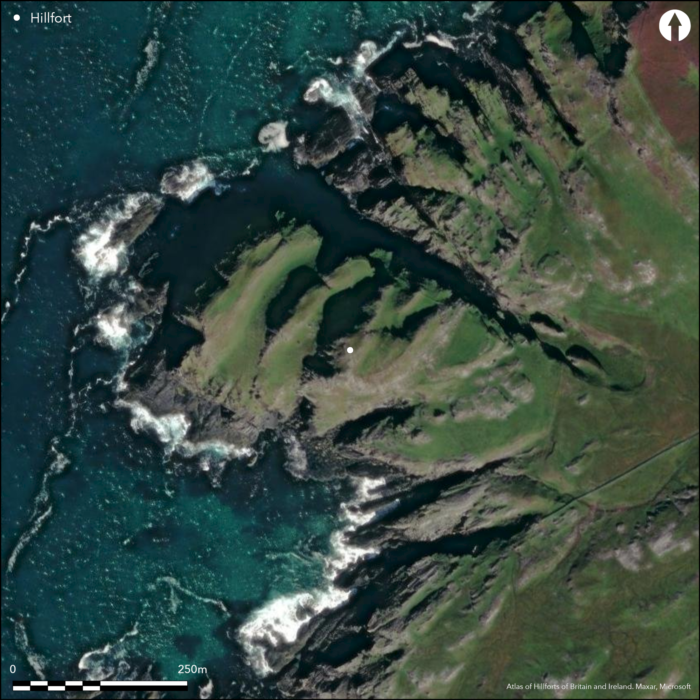
This large headland, girt by cliffs everywhere except the SE, is crossed transversely by a series of rocky ribs separated by grassy gullies, which combine to give a distinctive stepped profile from the S and forms a prominent landmark on Islay's W coast. Two walls cut across the neck of the promontory, the inner adopting the leading edge of the first of these ribs on the S before swinging round the top of a broad gully to descend the slope to the cliff-edge on the N, and the outer the edge of a terrace on the slope below it on the SE; at least two possible points of access are also blocked by short lengths of wall. To the NW the interior extends for a distance of some 165m (2.33ha) and includes two of the grassy gullies cutting transversely across its axis, though there is no trace of any occupation in either. On the upper slope of the rib behind the inner wall, however, there are at least seven small irregular platforms, which the RCAHMS investigators suggested were probably rectangular rather than circular, and were perhaps associated with another three that they believed overlay the entrance through the outer wall adjacent to the SW margin of the promontory. This takes in an additional 0.5ha, largely made up of the terrace below the inner wall, which has also been enclosed by a later field bank and cultivated in rigs. While the three platforms observed by RCAHMS are set across a natural ramp extending up the slope, the configuration of the defences at this point is unclear, partly on account of the heavy stone robbing, and the entrance may have been lower down the ramp, where a natural cleft in the outcrops provides a natural line of access through the wall and up onto the terrace. Despite the uncertainty about the precise course of the outer wall here, there is evidence of a wall following the outer margin of the ramp and the two lines may have overlapped to form a confined entrance passage. Two gaps have also been identified in the inner wall, controlling access to the seaward end of the promontory. The interior has evidently been enclosed and utilised in later periods, which, as RCAHMS suggest, may account for the construction of the small platforms.
Citizen Science: ✗
Reliability of Data: Confirmed
Reliability of Interpretation: Confirmed
X: -718805 Y: 7525245 (EPSG: 3857)
Longitude: -6.4571373752945265 Latitude: 55.833013702789195 (EPSG:4326)
Country: Scotland
Current County or Unitary Authority: Argyll & Bute
Historic County: Argyll
Current Parish/Community/Council/Townland: Kilchoman
None
| Extant | ✓ |
| Cropmark | ✗ |
| Likely Destroyed | ✗ |
None
| Woodland | ✗ |
| Commercial Forestry Plantation | ✗ |
| Parkland | ✗ |
| Pasture (Grazing) | ✓ |
| Arable | ✗ |
| Scrub/Bracken | ✗ |
| Bare Outcrop | ✗ |
| Heather/Moorland | ✗ |
| Heath | ✗ |
| Built-up | ✗ |
| Coastal Grassland | ✓ |
| Other | ✗ |
None
| Contour Fort | ✗ |
| Partial Contour Fort | ✗ |
| Promontory Fort | ✓ |
| Hillslope Fort | ✗ |
| Level Terrain Fort | ✗ |
| Marsh Fort | ✗ |
| Multiple Enclosure Fort | ✗ |
| Hilltop | ✗ |
| Coastal Promontory | ✓ |
| Inland Promontory | ✗ |
| Valley Bottom | ✗ |
| Knoll/Hillock/Outcrop | ✗ |
| Ridge | ✗ |
| Cliff/Plateau-edge/Scarp | ✗ |
| Hillslope | ✗ |
| Lowland | ✗ |
| Spur | ✗ |
Dominant Topographic Feature: A promontory with a very distinctive stepped profile from the S.
| North | ✗ |
| Northeast | ✗ |
| East | ✗ |
| Southeast | ✗ |
| South | ✗ |
| Southwest | ✗ |
| West | ✗ |
| Northwest | ✗ |
| Level | ✓ |
Altitude: 60.0m
N/A
In the absence of excavation, there are neither stratified artefacts nor radiocarbon dates to provide a chronology for the defences.
Reliability: D - None
| Pre 1200BC | ✗ |
| 1200BC - 800BC | ✗ |
| 800BC - 400BC | ✗ |
| 400BC - AD50 | ✗ |
| AD50 - AD400 | ✗ |
| AD400 - AD 800 | ✗ |
| Post AD800 | ✗ |
| Unknown | ✓ |
| Pre Hillfort: | None |
| Post Hillfort: | Traces of field bank extending around the margin of the promontory, and cultivation rigs |
While the New Statistical Account alludes to several fortified promontories in the parish of Kilchoman, attributing them to the Danes (NSA, 7, Argyle, 651), the fort is not shown on either the 1st or 2nd editions of the OS 6-inch map, which merely depicts the dun named Dun nan Nighean on the adjacent promontory on the N (Argyll and Bute 1882, sheet 196.6). It is, however noted by the Islay survey group (Celoria 1960, 1/30), and was visited subsequently by Frank Newall (Newall 1963). It was visited by the OS in 1978 and surveyed by RCAHMS during the preparation of the County Inventory for Argyll in 1979 (RCAHMS 1984, 86-8, no.144); it was photographed from the air by RCAHMS in 1977, 2005 and 2011. It was Scheduled in 2013.
| 1st Identified Written Reference (1960): | Description (Celoria 1960, 1/30) |
| Other (1963): | Noted by Frank Newall (1963) |
| Earthwork Survey (1979): | Plans and description (RCAHMS 1984, 86-8, no.144; RCAHMS DC136-9) |
| 1st Identified Map Depiction (1979): | Surveyed at 1:10.000 by the OS |
| Other (2007): | Visited by the Hill-Fort Study Group |
| Other (2013): | Scheduled |
Traces of
None
| None | ✓ |
| Spring | ✗ |
| Stream | ✗ |
| Pool | ✗ |
| Flush | ✗ |
| Well | ✗ |
| Other | ✗ |
irregular rectilinear platforms
| No Known Features | ✗ |
| Round Stone Structures | ✗ |
| Rectangular Stone Structures | ✗ |
| Curvilinear Platforms | ✗ |
| Other Roundhouse Evidence | ✗ |
| Pits | ✗ |
| Quarry Hollows | ✗ |
| Other | ✓ |
None
| No Known Excavation | ✓ |
| Pits | ✗ |
| Postholes | ✗ |
| Roundhouses | ✗ |
| Rectangular Structures | ✗ |
| Roads/Tracks | ✗ |
| Quarry Hollows | ✗ |
| Other | ✗ |
| Nothing Found | ✗ |
None
| No Known Geophysics | ✓ |
| Pits | ✗ |
| Roundhouses | ✗ |
| Rectangular Structures | ✗ |
| Roads/Tracks | ✗ |
| Quarry Hollows | ✗ |
| Other | ✗ |
| Nothing Found | ✗ |
None
| No Known Finds | ✓ |
| Pottery | ✗ |
| Metal | ✗ |
| Metalworking | ✗ |
| Human Bones | ✗ |
| Animal Bones | ✗ |
| Lithics | ✗ |
| Environmental | ✗ |
| Other | ✗ |
PLatforms
| APs Not Checked | ✗ |
| None | ✗ |
| Roundhouses | ✗ |
| Rectangular Structures | ✓ |
| Pits | ✗ |
| Postholes | ✗ |
| Roads/Tracks | ✗ |
| Other | ✗ |
See main summary
| 3: | None |
| 2: | One overall entrance in the outer line, but another two in the inner defences |
Guard Chambers: ✗
Chevaux de Frise: ✗
| 1. Over-lapping (South east): | Outer wall |
| 1. Oblique (South east): | Oblique approach along outcrop terrace to outer wall exposing the right side |
| 2. Simple Gap (South east): | Inner wall |
| 3. Simple Gap (South east): | Inner wall |
Two walls cutting off the promontory
| Area 1: | 2.33ha. |
| Total: | 2.33ha. |
Total Footprint Area: 2.9ha.
None
| ✗ | None |
| ✗ | None |
| NE Quadrant: | 0 |
| SE Quadrant: | 2 |
| SW Quadrant: | 0 |
| NW Quadrant: | 0 |
| Total: | 2 |
| Partial Univallate | ✗ |
| Univallate | ✗ |
| Partial Bivallate | ✓ |
| Bivallate | ✗ |
| Partial Multivallate | ✗ |
| Multivallate | ✗ |
| Unknown | ✗ |
| Partial Univallate | ✗ |
| Univallate | ✗ |
| Partial Bivallate | ✗ |
| Bivallate | ✗ |
| Partial Multivallate | ✗ |
| Multivallate | ✗ |
None
| None | ✗ |
| Earthen Bank | ✗ |
| Stone Wall | ✓ |
| Rubble | ✗ |
| Wall-walk | ✗ |
| Evidence of Timber | ✗ |
| Vitrification | ✗ |
| Other Burning | ✗ |
| Palisade | ✗ |
| Counter Scarp Bank | ✗ |
| Berm | ✗ |
| Unfinished | ✗ |
| Other | ✗ |
None
| None | ✗ |
| Earthen Bank | ✗ |
| Stone Wall | ✗ |
| Murus Duplex | ✗ |
| Timber-framed | ✗ |
| Timber-laced | ✗ |
| Vitrification | ✗ |
| Other Burning | ✗ |
| Palisade | ✗ |
| Counter Scarp Bank | ✗ |
| Berm | ✗ |
| Unfinished | ✗ |
| No Known Excavation | ✓ |
| Other | ✗ |
| ✗ | None |
| ✗ | None |
Number of Ditches: None
| ✗ | The outer rampart is sufficiently far out from the inner that it might be considered to have formed an annexe, but it may equally have formed a freestanding inner line of defence in its own right, cutting off a total area of 2.8ha. |
Celoria, F (1960) Islay gazetteer
Newall, F (1963) 'Forts and enclosures'. Disc Exc Scot 1963, 13
RCAHMS (1984) The Royal Commission on the Ancient and Historical Monuments of Scotland. Argyll: an inventory of the monuments volume 5: Islay, Jura, Colonsay and Oronsay. HMSO: Edinburgh
Atlas of Hillforts:
Wikidata:
This work is licensed under CC BY-SA 4.0![]()
![]()
![]() and should be cited as:
and should be cited as:
Lock, Gary and Ralston, Ian. 2024. Atlas of Hillforts of Britain and Ireland. Available at: https://hillforts.arch.ox.ac.uk
Document Version 1.1