Satellite Imagery
Satellite Imagery
HER: The West of Scotland Archaeology Service 2501 (None)
NMR: NR 39 SE 3 (37904)
SM: 5973
NGR: NR 3822 9439
X: 138220 Y: 694390 (OSGB36)
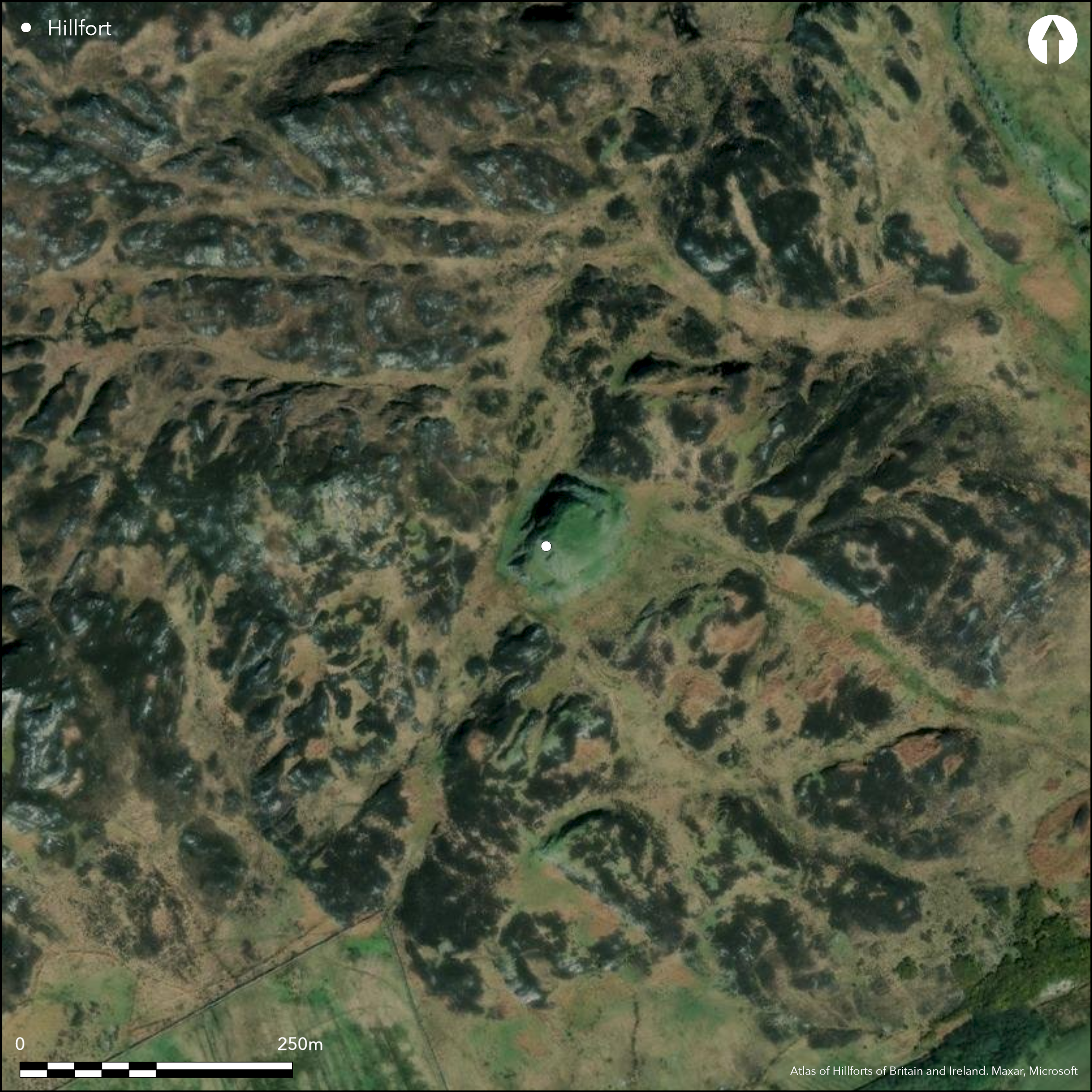
This small fortification is situated on a rocky hillock and measures 20m from NNE to SSW by 18m transversely (0.03ha) within a defence comprising two widely spaced walls, the inner extending round the margin of the summit area, and the outer along the edge of a terrace on the slope below it. The outer is heavily robbed, but short lengths of outer face are visible around its circuit. Substantial portions of the outer face of the inner remain in place, standing up to 0.8m high in six courses, and though no trace of the inner is visible the wall probably measured at least 4m in thickness. The entrance is on the NE and the interior is occupied by at least five rectangular buildings, the best preserved of which measures about 5.6m by 3.2m within a wall 1.6m thick.
Citizen Science: ✗
Reliability of Data: Confirmed
Reliability of Interpretation: Confirmed
X: -691069 Y: 7572467 (EPSG: 3857)
Longitude: -6.207977052135055 Latitude: 56.0705207781111 (EPSG:4326)
Country: Scotland
Current County or Unitary Authority: Argyll & Bute
Historic County: Argyll
Current Parish/Community/Council/Townland: Colonsay And Oronsay
None
| Extant | ✓ |
| Cropmark | ✗ |
| Likely Destroyed | ✗ |
None
| Woodland | ✗ |
| Commercial Forestry Plantation | ✗ |
| Parkland | ✗ |
| Pasture (Grazing) | ✗ |
| Arable | ✗ |
| Scrub/Bracken | ✗ |
| Bare Outcrop | ✗ |
| Heather/Moorland | ✓ |
| Heath | ✗ |
| Built-up | ✗ |
| Coastal Grassland | ✗ |
| Other | ✗ |
None
| Contour Fort | ✓ |
| Partial Contour Fort | ✗ |
| Promontory Fort | ✗ |
| Hillslope Fort | ✗ |
| Level Terrain Fort | ✗ |
| Marsh Fort | ✗ |
| Multiple Enclosure Fort | ✗ |
| Hilltop | ✗ |
| Coastal Promontory | ✗ |
| Inland Promontory | ✗ |
| Valley Bottom | ✗ |
| Knoll/Hillock/Outcrop | ✓ |
| Ridge | ✗ |
| Cliff/Plateau-edge/Scarp | ✗ |
| Hillslope | ✗ |
| Lowland | ✗ |
| Spur | ✗ |
Dominant Topographic Feature: None
| North | ✗ |
| Northeast | ✗ |
| East | ✗ |
| Southeast | ✗ |
| South | ✗ |
| Southwest | ✗ |
| West | ✗ |
| Northwest | ✗ |
| Level | ✓ |
Altitude: 85.0m
N/A
In the absence of excavation, there are neither stratified artefacts nor radiocarbon dates to provide a chronology for the defences.
Reliability: D - None
| Pre 1200BC | ✗ |
| 1200BC - 800BC | ✗ |
| 800BC - 400BC | ✗ |
| 400BC - AD50 | ✗ |
| AD50 - AD400 | ✗ |
| AD400 - AD 800 | ✗ |
| Post AD800 | ✗ |
| Unknown | ✓ |
| Pre Hillfort: | None |
| Post Hillfort: | The interior is occupied by buildings thought to be of late medieval date. |
First depicted in 1878 on the 1st edition OS 6-inch map (Argyll and Bute 1881, sheet 155), it was photographed by Erskine Beveridge in 1898. It was subsequently visited by Symington Grieve in the early 1920s, and in 1944 by Stuart and Margaret Piggott, who prepared a plan (Piggott and Piggott 1946, 88-9, fig 4). It was surveyed at 1:2500 by the OS in 1974, and in 1977 by RCAHMS for the County Inventory of Argyll (RCAHMS 1984, 89-90, no.149). It was Scheduled in 1994.
| 1st Identified Map Depiction (1878): | Named in Gothic type on the 1st edition OS 6-inch map (Argyll and Bute 1881, sheet 155) |
| Other (1898): | Photographed by Erskine Beveridge |
| Other (1920): | Visited by Symington Grieve in the early 1920s |
| Earthwork Survey (1944): | Stuart and Margaret Piggott (Piggott and Piggott 1946, 88-9, fig 4) |
| Other (1974): | Surveyed at 1:2500 by the OS |
| Earthwork Survey (1977): | Plan and description (RCAHMS 1984, 89-90, no.149; RCAHMS 149-50) |
| Other (1994): | Scheduled |
Occupied by rectangular buildings
None
| None | ✓ |
| Spring | ✗ |
| Stream | ✗ |
| Pool | ✗ |
| Flush | ✗ |
| Well | ✗ |
| Other | ✗ |
None
| No Known Features | ✗ |
| Round Stone Structures | ✗ |
| Rectangular Stone Structures | ✓ |
| Curvilinear Platforms | ✗ |
| Other Roundhouse Evidence | ✗ |
| Pits | ✗ |
| Quarry Hollows | ✗ |
| Other | ✗ |
None
| No Known Excavation | ✓ |
| Pits | ✗ |
| Postholes | ✗ |
| Roundhouses | ✗ |
| Rectangular Structures | ✗ |
| Roads/Tracks | ✗ |
| Quarry Hollows | ✗ |
| Other | ✗ |
| Nothing Found | ✗ |
None
| No Known Geophysics | ✓ |
| Pits | ✗ |
| Roundhouses | ✗ |
| Rectangular Structures | ✗ |
| Roads/Tracks | ✗ |
| Quarry Hollows | ✗ |
| Other | ✗ |
| Nothing Found | ✗ |
None
| No Known Finds | ✓ |
| Pottery | ✗ |
| Metal | ✗ |
| Metalworking | ✗ |
| Human Bones | ✗ |
| Animal Bones | ✗ |
| Lithics | ✗ |
| Environmental | ✗ |
| Other | ✗ |
None
| APs Not Checked | ✗ |
| None | ✗ |
| Roundhouses | ✗ |
| Rectangular Structures | ✓ |
| Pits | ✗ |
| Postholes | ✗ |
| Roads/Tracks | ✗ |
| Other | ✗ |
See main summary
| 1: | None |
| 2: | None |
Guard Chambers: ✗
Chevaux de Frise: ✗
| 1. Simple Gap (North east): | Entirely robbed of any stonework |
Two walls round most of the circuit
| Area 1: | 0.03ha. |
| Total: | 0.03ha. |
Total Footprint Area: 0.18ha.
None
| ✗ | None |
| ✓ | None |
| NE Quadrant: | 2 |
| SE Quadrant: | 2 |
| SW Quadrant: | 2 |
| NW Quadrant: | 1 |
| Total: | 2 |
| Partial Univallate | ✓ |
| Univallate | ✗ |
| Partial Bivallate | ✓ |
| Bivallate | ✗ |
| Partial Multivallate | ✗ |
| Multivallate | ✗ |
| Unknown | ✗ |
| Partial Univallate | ✗ |
| Univallate | ✗ |
| Partial Bivallate | ✗ |
| Bivallate | ✗ |
| Partial Multivallate | ✗ |
| Multivallate | ✗ |
None
| None | ✗ |
| Earthen Bank | ✗ |
| Stone Wall | ✓ |
| Rubble | ✗ |
| Wall-walk | ✗ |
| Evidence of Timber | ✗ |
| Vitrification | ✗ |
| Other Burning | ✗ |
| Palisade | ✗ |
| Counter Scarp Bank | ✗ |
| Berm | ✗ |
| Unfinished | ✗ |
| Other | ✗ |
None
| None | ✗ |
| Earthen Bank | ✗ |
| Stone Wall | ✗ |
| Murus Duplex | ✗ |
| Timber-framed | ✗ |
| Timber-laced | ✗ |
| Vitrification | ✗ |
| Other Burning | ✗ |
| Palisade | ✗ |
| Counter Scarp Bank | ✗ |
| Berm | ✗ |
| Unfinished | ✗ |
| No Known Excavation | ✓ |
| Other | ✗ |
| ✗ | None |
| ✗ | None |
Number of Ditches: None
| ✗ | None |
Grieve, S (1923) The book of Colonsay and Oronsay: forty-four years of research and discovery in early Scoto-Irish, Norse and Danish history [...], 2v Edinburgh
Name Book, Ordnance Survey Object Name Books (6 inch and 1/2500 scale); available https://www.scotlandsplaces.gov.uk/
Piggott and Piggott, S and C M (1946) 'Field work on Colonsay and Islay, 1944-45'. Proc Soc Antiq Scot 80 (1945-6), 83-103
RCAHMS (1984) The Royal Commission on the Ancient and Historical Monuments of Scotland. Argyll: an inventory of the monuments volume 5: Islay, Jura, Colonsay and Oronsay. HMSO: Edinburgh
Atlas of Hillforts:
Wikidata:
This work is licensed under CC BY-SA 4.0![]()
![]()
![]() and should be cited as:
and should be cited as:
Lock, Gary and Ralston, Ian. 2024. Atlas of Hillforts of Britain and Ireland. Available at: https://hillforts.arch.ox.ac.uk
Document Version 1.1