Satellite Imagery
Satellite Imagery
HER: The West of Scotland Archaeology Service 2643 (None)
NMR: NR 45 SE 10 (38050)
SM: 5659
NGR: NR 4679 5264
X: 146790 Y: 652640 (OSGB36)
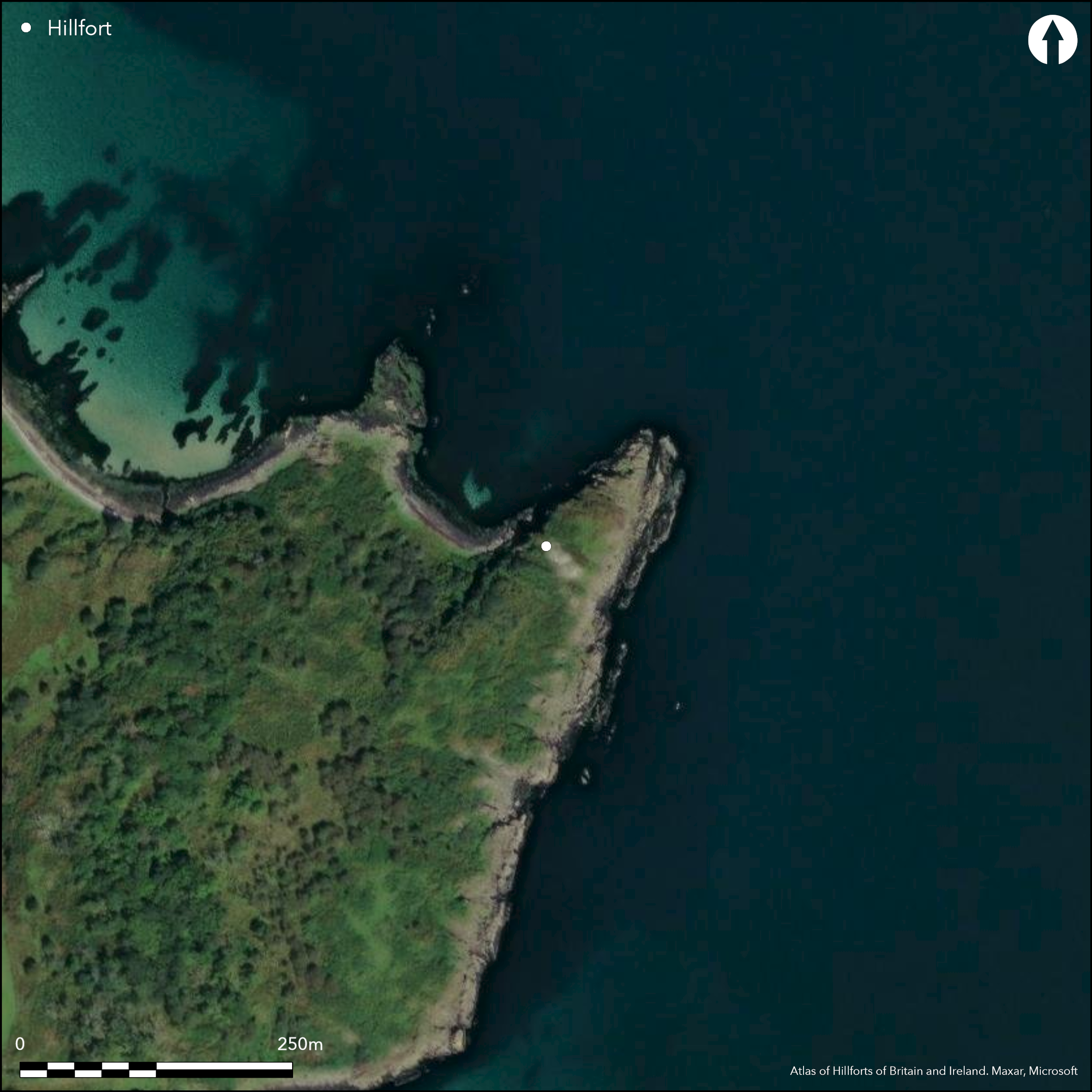
This small fortification occupies the headland known as Trudernish point. The irregular interior on the top of the promontory measures no more than 30m from NE to SW by a maximum of 25m transversely (0.07ha), and is defended on the SW by no less than three walls, the inner of which is massively vitrified and forms a bank of rubble up to 5m thick by 3.2m high externally and 2m internally. The middle wall is up to 2m thick, with long runs of massive outer facing-stones, while the outer is comparatively slight, comprising little more than two runs of outer face incorporated into a later stone dyke. Nothing is visible of the entrance, though RCAHMS investigators suggested that a dip in the crest of the inner wall roughly midway along its length might mark its position.
Citizen Science: ✗
Reliability of Data: Confirmed
Reliability of Interpretation: Confirmed
X: -671438 Y: 7499111 (EPSG: 3857)
Longitude: -6.031625707369575 Latitude: 55.70094548018673 (EPSG:4326)
Country: Scotland
Current County or Unitary Authority: Argyll & Bute
Historic County: Argyll
Current Parish/Community/Council/Townland: Kildalton And Oa
None
| Extant | ✓ |
| Cropmark | ✗ |
| Likely Destroyed | ✗ |
None
| Woodland | ✗ |
| Commercial Forestry Plantation | ✗ |
| Parkland | ✗ |
| Pasture (Grazing) | ✗ |
| Arable | ✗ |
| Scrub/Bracken | ✓ |
| Bare Outcrop | ✗ |
| Heather/Moorland | ✓ |
| Heath | ✗ |
| Built-up | ✗ |
| Coastal Grassland | ✗ |
| Other | ✗ |
None
| Contour Fort | ✗ |
| Partial Contour Fort | ✗ |
| Promontory Fort | ✓ |
| Hillslope Fort | ✗ |
| Level Terrain Fort | ✗ |
| Marsh Fort | ✗ |
| Multiple Enclosure Fort | ✗ |
| Hilltop | ✗ |
| Coastal Promontory | ✓ |
| Inland Promontory | ✗ |
| Valley Bottom | ✗ |
| Knoll/Hillock/Outcrop | ✗ |
| Ridge | ✗ |
| Cliff/Plateau-edge/Scarp | ✗ |
| Hillslope | ✗ |
| Lowland | ✗ |
| Spur | ✗ |
Dominant Topographic Feature: None
| North | ✗ |
| Northeast | ✗ |
| East | ✗ |
| Southeast | ✗ |
| South | ✗ |
| Southwest | ✗ |
| West | ✗ |
| Northwest | ✗ |
| Level | ✓ |
Altitude: 15.0m
N/A
In the absence of excavation, there are neither stratified artefacts nor radiocarbon dates to provide a chronology for the defences.
Reliability: D - None
| Pre 1200BC | ✗ |
| 1200BC - 800BC | ✗ |
| 800BC - 400BC | ✗ |
| 400BC - AD50 | ✗ |
| AD50 - AD400 | ✗ |
| AD400 - AD 800 | ✗ |
| Post AD800 | ✗ |
| Unknown | ✓ |
| Pre Hillfort: | None |
| Post Hillfort: | Outer wall incorporated into a later field wall |
First depicted in 1878 on the 1st edition OS 25-inch map (Argyll and Bute 1881, sheet 221.9), it was noted by Gordon Childe in 1934 (Childe 1935, 82). RCAHMS drew up a plan in 1976 during the preparation of the County Inventory for Argyll (RCAHMS 1984, 101, no.168) and the OS visited in 1979. RCAHMS took aerial photographs in 1979 and 2006. It was Scheduled in 1993. It formed part of a Coastal Zone Assessment carried out by EASE Archaeology in 2003.
| 1st Identified Map Depiction (1878): | Named in Gothic type on the 1st edition OS 25-inch map (Argyll and Bute 1881, sheet 221.9) |
| Other (1934): | Description by Gordon Childe |
| Earthwork Survey (1976): | Plan and description (RCAHMS 1984, 101, no.168; RCAHMS DC183-4) |
| Other (1979): | Surveyed at 1:10.000 by the OS |
| Other (1993): | Scheduled (Childe 1935, 82) |
| Other (2003): | Visited by EASE Archaeology for a Coastal Zone Assessment |
| Other (2007): | Visited by the Hill-Fort Study Group |
Featureless
None
| None | ✓ |
| Spring | ✗ |
| Stream | ✗ |
| Pool | ✗ |
| Flush | ✗ |
| Well | ✗ |
| Other | ✗ |
None
| No Known Features | ✓ |
| Round Stone Structures | ✗ |
| Rectangular Stone Structures | ✗ |
| Curvilinear Platforms | ✗ |
| Other Roundhouse Evidence | ✗ |
| Pits | ✗ |
| Quarry Hollows | ✗ |
| Other | ✗ |
None
| No Known Excavation | ✓ |
| Pits | ✗ |
| Postholes | ✗ |
| Roundhouses | ✗ |
| Rectangular Structures | ✗ |
| Roads/Tracks | ✗ |
| Quarry Hollows | ✗ |
| Other | ✗ |
| Nothing Found | ✗ |
None
| No Known Geophysics | ✓ |
| Pits | ✗ |
| Roundhouses | ✗ |
| Rectangular Structures | ✗ |
| Roads/Tracks | ✗ |
| Quarry Hollows | ✗ |
| Other | ✗ |
| Nothing Found | ✗ |
None
| No Known Finds | ✓ |
| Pottery | ✗ |
| Metal | ✗ |
| Metalworking | ✗ |
| Human Bones | ✗ |
| Animal Bones | ✗ |
| Lithics | ✗ |
| Environmental | ✗ |
| Other | ✗ |
NO APPARENT FEATURES
| APs Not Checked | ✗ |
| None | ✓ |
| Roundhouses | ✗ |
| Rectangular Structures | ✗ |
| Pits | ✗ |
| Postholes | ✗ |
| Roads/Tracks | ✗ |
| Other | ✗ |
See main summary
| 0: | None |
| 2: | No clearly visible entrance |
Guard Chambers: ✗
Chevaux de Frise: ✗
Three walls cutting across the neck of a promontory
| Area 1: | 0.07ha. |
| Total: | 0.07ha. |
Total Footprint Area: 0.15ha.
None
| ✗ | None |
| ✗ | None |
| NE Quadrant: | 0 |
| SE Quadrant: | 0 |
| SW Quadrant: | 3 |
| NW Quadrant: | 0 |
| Total: | 3 |
| Partial Univallate | ✗ |
| Univallate | ✗ |
| Partial Bivallate | ✗ |
| Bivallate | ✗ |
| Partial Multivallate | ✓ |
| Multivallate | ✗ |
| Unknown | ✗ |
| Partial Univallate | ✗ |
| Univallate | ✗ |
| Partial Bivallate | ✗ |
| Bivallate | ✗ |
| Partial Multivallate | ✗ |
| Multivallate | ✗ |
None
| None | ✗ |
| Earthen Bank | ✗ |
| Stone Wall | ✓ |
| Rubble | ✗ |
| Wall-walk | ✗ |
| Evidence of Timber | ✗ |
| Vitrification | ✓ |
| Other Burning | ✗ |
| Palisade | ✗ |
| Counter Scarp Bank | ✗ |
| Berm | ✗ |
| Unfinished | ✗ |
| Other | ✗ |
None
| None | ✗ |
| Earthen Bank | ✗ |
| Stone Wall | ✗ |
| Murus Duplex | ✗ |
| Timber-framed | ✗ |
| Timber-laced | ✗ |
| Vitrification | ✗ |
| Other Burning | ✗ |
| Palisade | ✗ |
| Counter Scarp Bank | ✗ |
| Berm | ✗ |
| Unfinished | ✗ |
| No Known Excavation | ✓ |
| Other | ✗ |
| ✗ | None |
| ✗ | None |
Number of Ditches: None
| ✗ | None |
Childe, V G (1935) 'Notes on some duns in Islay'. Proc Soc Antiq Scot 69 (1934-5), 81-4
Moore, H. & Wilson, G. (2003) EASE Archaeology, 'Report on a Coastal Zone Assessment Survey of Islay'
RCAHMS (1984) The Royal Commission on the Ancient and Historical Monuments of Scotland. Argyll: an inventory of the monuments volume 5: Islay, Jura, Colonsay and Oronsay. HMSO: Edinburgh
Shanks, I D (1972) 'Trudernish Point', Discovery Excav Scot 1972, 5
Atlas of Hillforts:
Wikidata:
This work is licensed under CC BY-SA 4.0![]()
![]()
![]() and should be cited as:
and should be cited as:
Lock, Gary and Ralston, Ian. 2024. Atlas of Hillforts of Britain and Ireland. Available at: https://hillforts.arch.ox.ac.uk
Document Version 1.1