Satellite Imagery
Satellite Imagery
HER: The West of Scotland Archaeology Service 2677 (None)
NMR: NR 45 SE 6 (38084)
SM: 5658
NGR: NR 4661 5407
X: 146610 Y: 654070 (OSGB36)
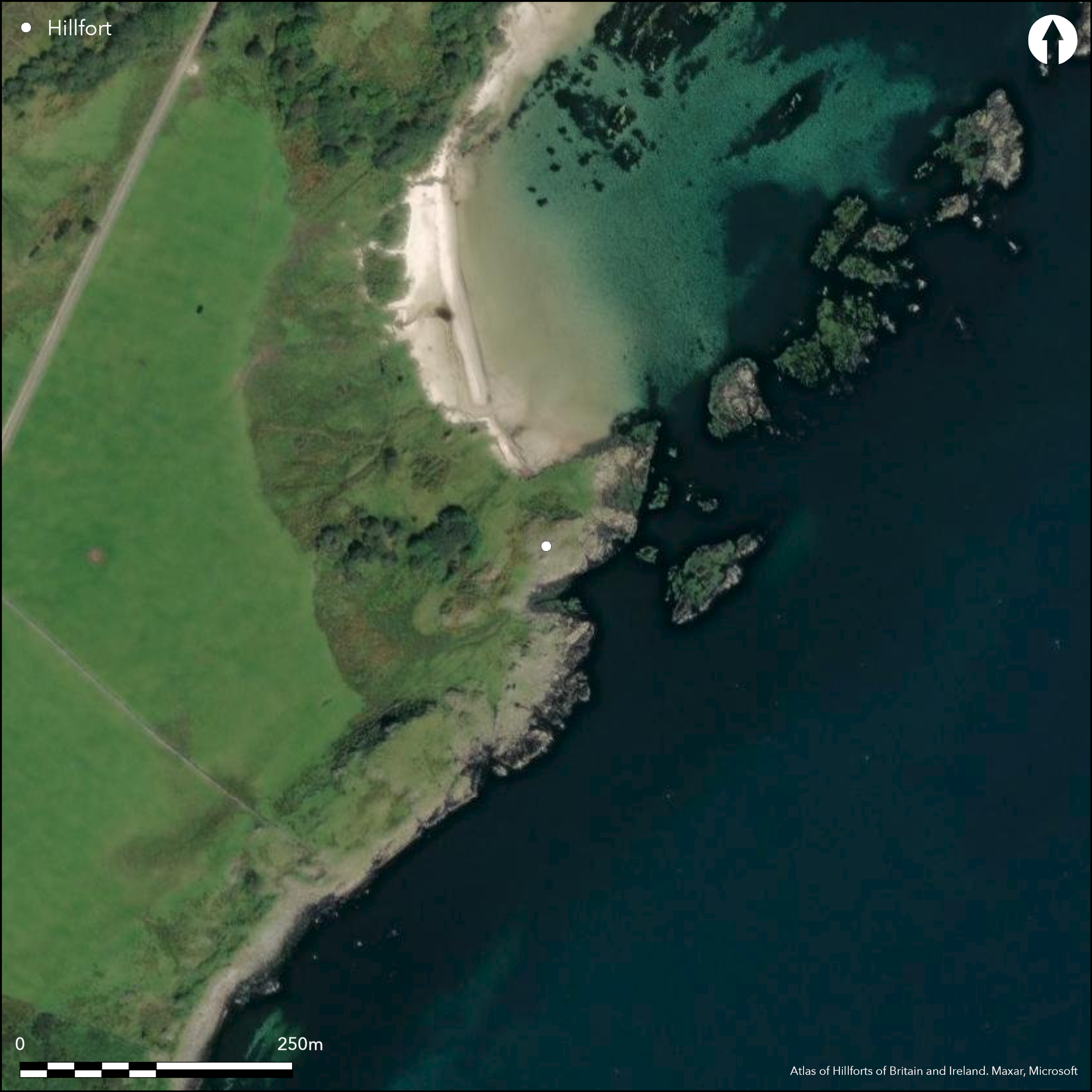
This small promontory work is situated on a low promontory 450m S of Ardtalla. The promontory itself has few defensive qualities, but access from the landward side on the W quarter is blocked by no less than three wall, the inner of which forms a thick band of rubble up to 1.4m high and has small patches of vitrifaction visible in it. The middle wall is about 2.4m in thickness and has long runs of its outer face visible, in places still standing 0.9m high in two courses, while the outer is not only more fragmentary but only measures 1.3m in thickness. Access to the entrance passage through the inner wall, one side of which is exposed on the NW, was probably gained through a gap in the outcrops that separates the inner and middle walls on the N and is now blocked by a modern drystone dyke. The interior measures no more than 16m from NNE to SSW by 11m transversely (0.02ha) and is largely obscured by two piles of stones.
Citizen Science: ✗
Reliability of Data: Confirmed
Reliability of Interpretation: Confirmed
X: -671903 Y: 7501625 (EPSG: 3857)
Longitude: -6.035805590844484 Latitude: 55.713668604874954 (EPSG:4326)
Country: Scotland
Current County or Unitary Authority: Argyll & Bute
Historic County: Argyll
Current Parish/Community/Council/Townland: Kildalton And Oa
None
| Extant | ✓ |
| Cropmark | ✗ |
| Likely Destroyed | ✗ |
None
| Woodland | ✗ |
| Commercial Forestry Plantation | ✗ |
| Parkland | ✗ |
| Pasture (Grazing) | ✓ |
| Arable | ✗ |
| Scrub/Bracken | ✗ |
| Bare Outcrop | ✗ |
| Heather/Moorland | ✗ |
| Heath | ✗ |
| Built-up | ✗ |
| Coastal Grassland | ✓ |
| Other | ✗ |
None
| Contour Fort | ✗ |
| Partial Contour Fort | ✗ |
| Promontory Fort | ✓ |
| Hillslope Fort | ✗ |
| Level Terrain Fort | ✗ |
| Marsh Fort | ✗ |
| Multiple Enclosure Fort | ✗ |
| Hilltop | ✗ |
| Coastal Promontory | ✓ |
| Inland Promontory | ✗ |
| Valley Bottom | ✗ |
| Knoll/Hillock/Outcrop | ✗ |
| Ridge | ✗ |
| Cliff/Plateau-edge/Scarp | ✗ |
| Hillslope | ✗ |
| Lowland | ✗ |
| Spur | ✗ |
Dominant Topographic Feature: None
| North | ✗ |
| Northeast | ✗ |
| East | ✗ |
| Southeast | ✗ |
| South | ✗ |
| Southwest | ✗ |
| West | ✗ |
| Northwest | ✗ |
| Level | ✓ |
Altitude: 5.0m
N/A
In the absence of excavation, there are neither stratified artefacts nor radiocarbon dates to provide a chronology for the defences.
Reliability: D - None
| Pre 1200BC | ✗ |
| 1200BC - 800BC | ✗ |
| 800BC - 400BC | ✗ |
| 400BC - AD50 | ✗ |
| AD50 - AD400 | ✗ |
| AD400 - AD 800 | ✗ |
| Post AD800 | ✗ |
| Unknown | ✓ |
| Pre Hillfort: | None |
| Post Hillfort: | Much disturbed abd the gaps in the outcrops on the N are blocked by modern dykes. A boat-noost lies immediately to the SW |
First depicted in 1878 on the 1st edition OS 25-inch map (Argyll and Bute 1881, 221.9), it was visited by Gordon Childe in 1934 (Childe 1935, 81), and may also have been included in RCAHMS wartime Emergency Surveys in 1942. The Islay Survey Group visited the site (Celoria 1959, 7/11), and it was surveyed in 1977 by RCAHMS during the preparation of the County Inventory for Argyll (RCAHMS 1984, 112, no.204), The OS subsequently visited in 1979, the same year in which it was photographed from the air by RCAHMS. It was Scheduled in 1993.
| 1st Identified Map Depiction (1878): | Named in Gothic type on the 1st edition OS 25-inch map (Argyll and Bute 1881, 221.9) |
| Other (1934): | Description (Childe 1935, 81) |
| Other (1959): | Visited by the Islay Survey Group (Celoria 1959, 7/11) |
| Earthwork Survey (1977): | Plan and description (RCAHMS 1984, 112, no.204; RCAHMS DC247-8) |
| Other (1979): | Surveyed at 1:10.000 by the OS |
| Other (1993): | Scheduled |
Featureless apart from two piles of stones that presumably relate to later activity.
None
| None | ✓ |
| Spring | ✗ |
| Stream | ✗ |
| Pool | ✗ |
| Flush | ✗ |
| Well | ✗ |
| Other | ✗ |
None
| No Known Features | ✓ |
| Round Stone Structures | ✗ |
| Rectangular Stone Structures | ✗ |
| Curvilinear Platforms | ✗ |
| Other Roundhouse Evidence | ✗ |
| Pits | ✗ |
| Quarry Hollows | ✗ |
| Other | ✗ |
None
| No Known Excavation | ✓ |
| Pits | ✗ |
| Postholes | ✗ |
| Roundhouses | ✗ |
| Rectangular Structures | ✗ |
| Roads/Tracks | ✗ |
| Quarry Hollows | ✗ |
| Other | ✗ |
| Nothing Found | ✗ |
None
| No Known Geophysics | ✓ |
| Pits | ✗ |
| Roundhouses | ✗ |
| Rectangular Structures | ✗ |
| Roads/Tracks | ✗ |
| Quarry Hollows | ✗ |
| Other | ✗ |
| Nothing Found | ✗ |
None
| No Known Finds | ✓ |
| Pottery | ✗ |
| Metal | ✗ |
| Metalworking | ✗ |
| Human Bones | ✗ |
| Animal Bones | ✗ |
| Lithics | ✗ |
| Environmental | ✗ |
| Other | ✗ |
NO APPARENT FEATURES
| APs Not Checked | ✗ |
| None | ✓ |
| Roundhouses | ✗ |
| Rectangular Structures | ✗ |
| Pits | ✗ |
| Postholes | ✗ |
| Roads/Tracks | ✗ |
| Other | ✗ |
See main summary
| 2: | None |
| 2: | Independent gaps in the inner and outer defences |
Guard Chambers: ✗
Chevaux de Frise: ✗
| 1. Simple Gap (North west): | in inner wall |
| 1. Simple Gap (North): | in outer defences |
Three walls cutting off a promontory
| Area 1: | 0.02ha. |
| Total: | 0.02ha. |
Total Footprint Area: Noneha.
None
| ✗ | None |
| ✗ | None |
| NE Quadrant: | 0 |
| SE Quadrant: | 0 |
| SW Quadrant: | 3 |
| NW Quadrant: | 0 |
| Total: | 3 |
| Partial Univallate | ✗ |
| Univallate | ✗ |
| Partial Bivallate | ✗ |
| Bivallate | ✗ |
| Partial Multivallate | ✓ |
| Multivallate | ✗ |
| Unknown | ✗ |
| Partial Univallate | ✗ |
| Univallate | ✗ |
| Partial Bivallate | ✗ |
| Bivallate | ✗ |
| Partial Multivallate | ✗ |
| Multivallate | ✗ |
None
| None | ✗ |
| Earthen Bank | ✗ |
| Stone Wall | ✓ |
| Rubble | ✗ |
| Wall-walk | ✗ |
| Evidence of Timber | ✗ |
| Vitrification | ✗ |
| Other Burning | ✗ |
| Palisade | ✗ |
| Counter Scarp Bank | ✗ |
| Berm | ✗ |
| Unfinished | ✗ |
| Other | ✗ |
None
| None | ✗ |
| Earthen Bank | ✗ |
| Stone Wall | ✗ |
| Murus Duplex | ✗ |
| Timber-framed | ✗ |
| Timber-laced | ✗ |
| Vitrification | ✗ |
| Other Burning | ✗ |
| Palisade | ✗ |
| Counter Scarp Bank | ✗ |
| Berm | ✗ |
| Unfinished | ✗ |
| No Known Excavation | ✓ |
| Other | ✗ |
| ✗ | None |
| ✗ | None |
Number of Ditches: None
| ✗ | None |
Celoria, F (1959) Preliminary handbook to Islay, 7/11
Childe, V G (1935) 'Notes on some duns in Islay'. Proc Soc Antiq Scot 69 (1934-5), 81-4
RCAHMS (1984) The Royal Commission on the Ancient and Historical Monuments of Scotland. Argyll: an inventory of the monuments volume 5: Islay, Jura, Colonsay and Oronsay. HMSO: Edinburgh
Atlas of Hillforts:
Wikidata:
This work is licensed under CC BY-SA 4.0![]()
![]()
![]() and should be cited as:
and should be cited as:
Lock, Gary and Ralston, Ian. 2024. Atlas of Hillforts of Britain and Ireland. Available at: https://hillforts.arch.ox.ac.uk
Document Version 1.1