Satellite Imagery
Satellite Imagery
HER: The West of Scotland Archaeology Service 14524 (None)
NMR: NR 57 SE 4 (83073)
SM: None
NGR: NR 5785 7305
X: 157850 Y: 673050 (OSGB36)
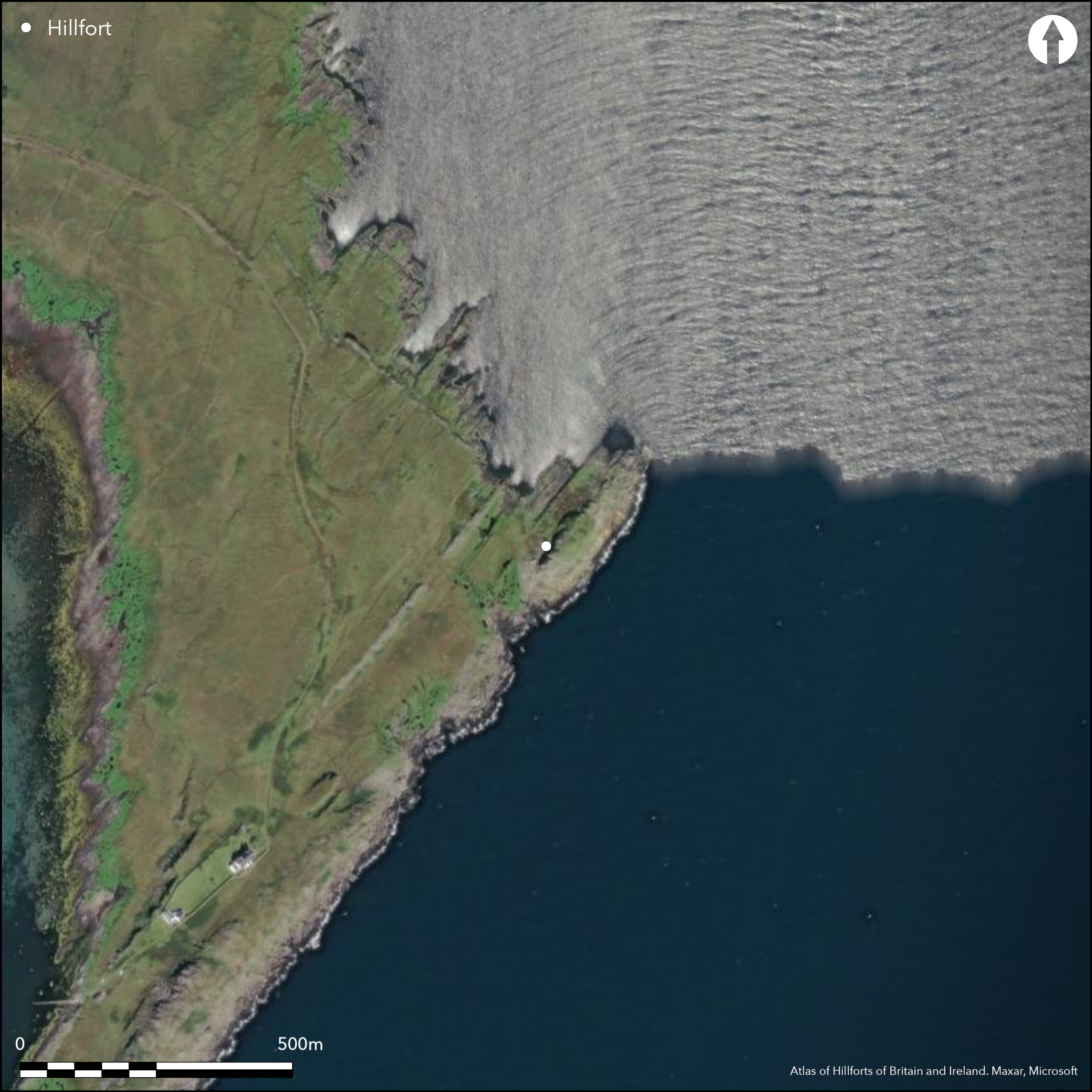
A complex series walls variously enclose the summit of this promontory and a lower terrace on the NW, and cut off the landward approach from the W, As such it may represent several separate periods and schemes of defence. At its core are the remains of the small enclosure on the summit, which measures no more than 25m from NNE to SSW by 20m transversely (0.05ha) within a denuded wall reduced to little more than a thin band of rubble with occasional outer-facing stones. Two outer walls extend along the lips of lower terraces stepping down on the NE flank, the lower swinging round to the W, possibly to utilise the leading edge of another terrace at the foot of the NW flank of the promontory before returning to the foot of the cliff forming the W side of the summit; as such it forms an annexe enclosing a further 0.19ha. The entrance to the innermost enclosure approaches through the annexe and up the NE flank of the summit, where an additional length of wall has been inserted parallel to the annexe wall to create a walled entrance way some 22m in length, though if this is what was intended it is unclear how access to the the entrance through the middle wall was gained. Entrance from the exterior into the annexe was via gap in the wall on the W, where there is also a gap in a slighter outer wall which cuts off access to the whole promontory on the landward side. Two structures are built into the innermost wall and the annexe wall respectively, in the case of the latter impeding the use of the entrance into the annexe on the W, are probably the result of later occupation; In addition there are a series of other later pens and huts, including a long rectangular structure in the annexe that the RCAHMS investigators speculated was a boat shelter.
Citizen Science: ✗
Reliability of Data: Confirmed
Reliability of Interpretation: Confirmed
X: -653913 Y: 7536462 (EPSG: 3857)
Longitude: -5.874202895109835 Latitude: 55.88956188495393 (EPSG:4326)
Country: Scotland
Current County or Unitary Authority: Argyll & Bute
Historic County: Argyll
Current Parish/Community/Council/Townland: Jura
None
| Extant | ✓ |
| Cropmark | ✗ |
| Likely Destroyed | ✗ |
None
| Woodland | ✗ |
| Commercial Forestry Plantation | ✗ |
| Parkland | ✗ |
| Pasture (Grazing) | ✓ |
| Arable | ✗ |
| Scrub/Bracken | ✗ |
| Bare Outcrop | ✗ |
| Heather/Moorland | ✗ |
| Heath | ✗ |
| Built-up | ✗ |
| Coastal Grassland | ✓ |
| Other | ✗ |
None
| Contour Fort | ✓ |
| Partial Contour Fort | ✗ |
| Promontory Fort | ✓ |
| Hillslope Fort | ✗ |
| Level Terrain Fort | ✗ |
| Marsh Fort | ✗ |
| Multiple Enclosure Fort | ✗ |
| Hilltop | ✗ |
| Coastal Promontory | ✓ |
| Inland Promontory | ✗ |
| Valley Bottom | ✗ |
| Knoll/Hillock/Outcrop | ✗ |
| Ridge | ✗ |
| Cliff/Plateau-edge/Scarp | ✗ |
| Hillslope | ✗ |
| Lowland | ✗ |
| Spur | ✗ |
Dominant Topographic Feature: None
| North | ✗ |
| Northeast | ✗ |
| East | ✗ |
| Southeast | ✗ |
| South | ✗ |
| Southwest | ✗ |
| West | ✗ |
| Northwest | ✗ |
| Level | ✓ |
Altitude: 20.0m
N/A
In the absence of excavation, there are neither stratified artefacts nor radiocarbon dates to provide a chronology for the defences.
Reliability: D - None
| Pre 1200BC | ✗ |
| 1200BC - 800BC | ✗ |
| 800BC - 400BC | ✗ |
| 400BC - AD50 | ✗ |
| AD50 - AD400 | ✗ |
| AD400 - AD 800 | ✗ |
| Post AD800 | ✗ |
| Unknown | ✓ |
| Pre Hillfort: | None |
| Post Hillfort: | Overlain by several huts and pens and a long rectangular structure thought to eb a boat shelter. |
First noted by M Jarvis (1974), the fort was surveyed by RCAHMS in 1976 during the preparation of the County Inventory for Argyll (RCAHMS 1984, 73-5, no.126), and visited by the OS in 1978. It was photographed from the air by RCAHMS in 1976, 1977 and 1980.
| 1st Identified Written Reference (1974): | Discovery (Jarvis 1974) |
| Earthwork Survey (1976): | Plan and description (RCAHMS 1984, 73-5, no.126; RCAHMS DC103-4) |
| 1st Identified Map Depiction (1978): | Surveyed at 1:10.000 by the OS |
Later enclosures and structures are scattered through the interior.
None
| None | ✓ |
| Spring | ✗ |
| Stream | ✗ |
| Pool | ✗ |
| Flush | ✗ |
| Well | ✗ |
| Other | ✗ |
Various huts, pens, gardens and other structures
| No Known Features | ✗ |
| Round Stone Structures | ✗ |
| Rectangular Stone Structures | ✓ |
| Curvilinear Platforms | ✗ |
| Other Roundhouse Evidence | ✗ |
| Pits | ✗ |
| Quarry Hollows | ✗ |
| Other | ✓ |
None
| No Known Excavation | ✓ |
| Pits | ✗ |
| Postholes | ✗ |
| Roundhouses | ✗ |
| Rectangular Structures | ✗ |
| Roads/Tracks | ✗ |
| Quarry Hollows | ✗ |
| Other | ✗ |
| Nothing Found | ✗ |
None
| No Known Geophysics | ✓ |
| Pits | ✗ |
| Roundhouses | ✗ |
| Rectangular Structures | ✗ |
| Roads/Tracks | ✗ |
| Quarry Hollows | ✗ |
| Other | ✗ |
| Nothing Found | ✗ |
None
| No Known Finds | ✓ |
| Pottery | ✗ |
| Metal | ✗ |
| Metalworking | ✗ |
| Human Bones | ✗ |
| Animal Bones | ✗ |
| Lithics | ✗ |
| Environmental | ✗ |
| Other | ✗ |
Various huts, pens, gardens and other structures
| APs Not Checked | ✗ |
| None | ✗ |
| Roundhouses | ✗ |
| Rectangular Structures | ✗ |
| Pits | ✗ |
| Postholes | ✗ |
| Roads/Tracks | ✗ |
| Other | ✓ |
See main summary
| 5: | but also other large gaps in the circuits |
| 2: | A single route to the summit enclosure via five separate gaps in the various walls |
Guard Chambers: ✗
Chevaux de Frise: ✗
| 1. Simple Gap (North east): | In inner wall, with fallen jambstone |
| 1. Simple Gap (North east): | Middle wall |
| 1. Passage-way/Corridor (North east): | approaching the inner entrances |
| 1. Simple Gap (West): | Through annexe wall |
| 1. Simple Gap (West): | Through outermost wall cutting off the promontory |
A complex series of defensive walls
| Area 1: | 0.05ha. |
| Total: | 0.05ha. |
Total Footprint Area: 0.8ha.
None
| ✗ | None |
| ✗ | None |
| NE Quadrant: | 1 |
| SE Quadrant: | 0 |
| SW Quadrant: | 2 |
| NW Quadrant: | 3 |
| Total: | 3 |
| Partial Univallate | ✓ |
| Univallate | ✗ |
| Partial Bivallate | ✓ |
| Bivallate | ✗ |
| Partial Multivallate | ✓ |
| Multivallate | ✗ |
| Unknown | ✗ |
| Partial Univallate | ✗ |
| Univallate | ✗ |
| Partial Bivallate | ✗ |
| Bivallate | ✗ |
| Partial Multivallate | ✗ |
| Multivallate | ✗ |
None
| None | ✗ |
| Earthen Bank | ✗ |
| Stone Wall | ✓ |
| Rubble | ✗ |
| Wall-walk | ✗ |
| Evidence of Timber | ✗ |
| Vitrification | ✗ |
| Other Burning | ✗ |
| Palisade | ✗ |
| Counter Scarp Bank | ✗ |
| Berm | ✗ |
| Unfinished | ✗ |
| Other | ✗ |
None
| None | ✗ |
| Earthen Bank | ✗ |
| Stone Wall | ✗ |
| Murus Duplex | ✗ |
| Timber-framed | ✗ |
| Timber-laced | ✗ |
| Vitrification | ✗ |
| Other Burning | ✗ |
| Palisade | ✗ |
| Counter Scarp Bank | ✗ |
| Berm | ✗ |
| Unfinished | ✗ |
| No Known Excavation | ✓ |
| Other | ✗ |
| ✗ | None |
| ✗ | None |
Number of Ditches: None
| ✓ | There is a possible annexe with a massively built wall on the NW of the summit enclosure, which extends its interior by a further 0.19ha |
Jarvis, M C (1974) 'Jura, An Dunan: fort', Discovery Excav Scot 1974, 13
RCAHMS (1984) The Royal Commission on the Ancient and Historical Monuments of Scotland. Argyll: an inventory of the monuments volume 5: Islay, Jura, Colonsay and Oronsay. HMSO: Edinburgh
Atlas of Hillforts:
Wikidata:
This work is licensed under CC BY-SA 4.0![]()
![]()
![]() and should be cited as:
and should be cited as:
Lock, Gary and Ralston, Ian. 2024. Atlas of Hillforts of Britain and Ireland. Available at: https://hillforts.arch.ox.ac.uk
Document Version 1.1