Satellite Imagery
Satellite Imagery
HER: The West of Scotland Archaeology Service 2932 (None)
NMR: NR 61 NE 8 (38340)
SM: 3639
NGR: NR 6777 1767
X: 167770 Y: 617670 (OSGB36)
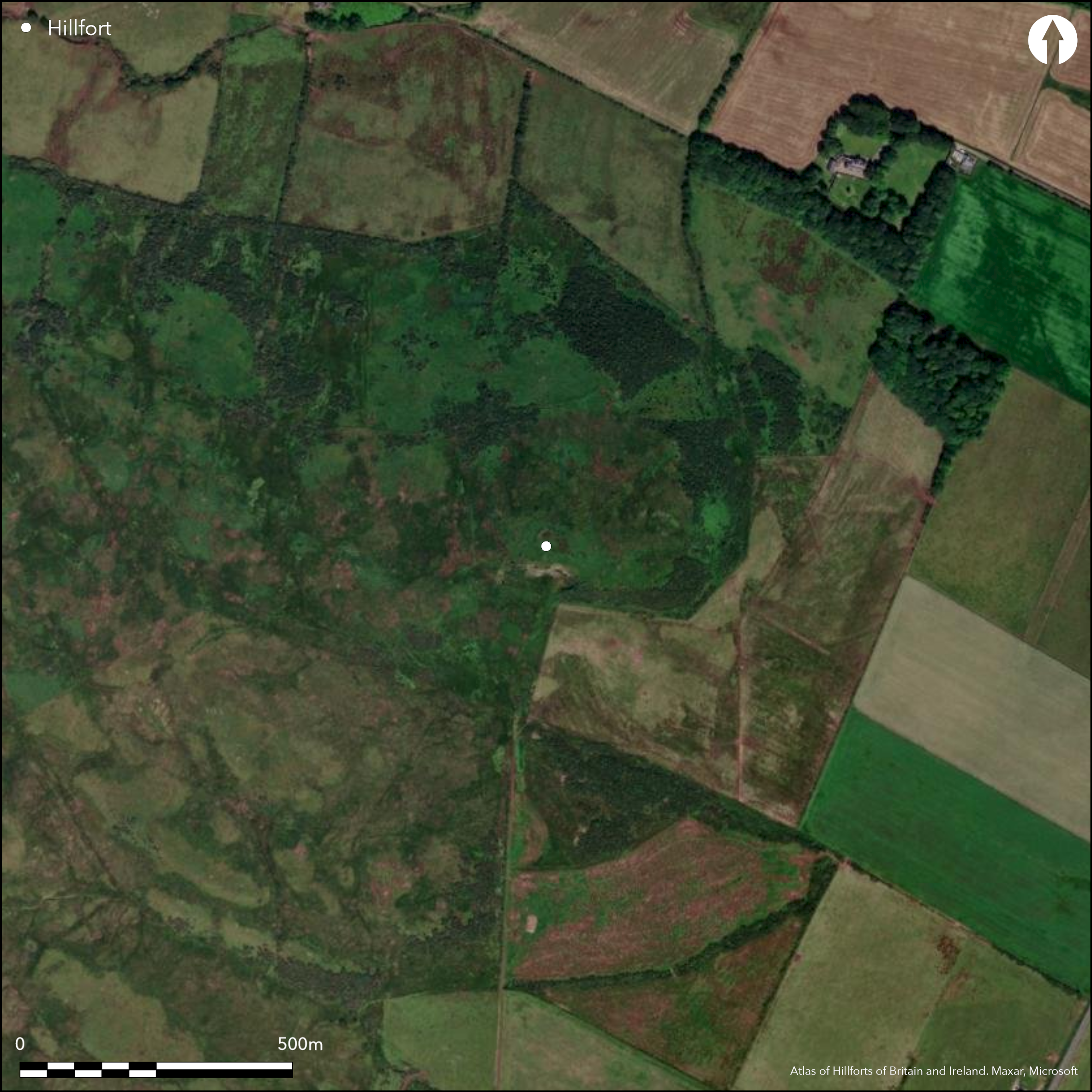
Two schemes of fortification, have been identified on the summit of Bealloch Hill, and though they appear to represent an inner circuit imposed eccentrically upon a multivallate outer perimeter, excavation was unable to demonstrate conclusively that they were successive. The inner measures about 40m from NW to SE by 27m transversely (0.08ha) within a stone wall reduced to a mound of rubble in which several runs of outer face and a few inner facing-stones are exposed; its entrance is on the ESE. The outer encloses an area measuring 58m from NW to SE by 44m transversely within a rampart reduced to little more than a scarp. Excavation suggested that the wall of the inner fort, which measured 3.5m in thickness, had been built in two separate phases, and at some stage was possibly furbished with a timber and wattle superstructure. The inner rampart of the outer defences was sectioned and shown to be about 2m thick, comprising a stone outer face with an earth and rubble core. The excavations also revealed traces of a third rampart outside it, with shallow dug slots to either side of its line; these outer defences also represented more than a single period of construction. Three subrectangular structures overlying the innermost wall were excavated and one produced most of the ten glass beads found on the site; these are not particularly helpful chronologically, and in the loose rubble may not be stratigraphically secure. Fragmentary traces of other structures suggesting sustained occupation were identified elsewhere in the interior.
Citizen Science: ✗
Reliability of Data: Confirmed
Reliability of Interpretation: Confirmed
X: -631087 Y: 7439471 (EPSG: 3857)
Longitude: -5.66915306926767 Latitude: 55.39786964905435 (EPSG:4326)
Country: Scotland
Current County or Unitary Authority: Argyll & Bute
Historic County: Argyll
Current Parish/Community/Council/Townland: Campbeltown
None
| Extant | ✓ |
| Cropmark | ✗ |
| Likely Destroyed | ✗ |
None
| Woodland | ✗ |
| Commercial Forestry Plantation | ✗ |
| Parkland | ✗ |
| Pasture (Grazing) | ✓ |
| Arable | ✗ |
| Scrub/Bracken | ✗ |
| Bare Outcrop | ✗ |
| Heather/Moorland | ✓ |
| Heath | ✗ |
| Built-up | ✗ |
| Coastal Grassland | ✗ |
| Other | ✗ |
None
| Contour Fort | ✓ |
| Partial Contour Fort | ✗ |
| Promontory Fort | ✗ |
| Hillslope Fort | ✗ |
| Level Terrain Fort | ✗ |
| Marsh Fort | ✗ |
| Multiple Enclosure Fort | ✗ |
| Hilltop | ✓ |
| Coastal Promontory | ✗ |
| Inland Promontory | ✗ |
| Valley Bottom | ✗ |
| Knoll/Hillock/Outcrop | ✗ |
| Ridge | ✗ |
| Cliff/Plateau-edge/Scarp | ✗ |
| Hillslope | ✗ |
| Lowland | ✗ |
| Spur | ✗ |
Dominant Topographic Feature: None
| North | ✗ |
| Northeast | ✗ |
| East | ✗ |
| Southeast | ✗ |
| South | ✗ |
| Southwest | ✗ |
| West | ✗ |
| Northwest | ✗ |
| Level | ✓ |
Altitude: 150.0m
N/A
Unsatisfactory dating with 14 old radiocarbon dates and relatively little useful contextual or sequential stratigraphy. At best the occupation of the fort appears to relate to the pre-Roman Iron Age and not to the early medieval period. The glass beads, most of which were found in one of the later stone structures, may date anywhere from the 1st century BC to the 8th century AD,
Reliability: C - Low
| Pre 1200BC | ✗ |
| 1200BC - 800BC | ✗ |
| 800BC - 400BC | ✓ |
| 400BC - AD50 | ✓ |
| AD50 - AD400 | ✗ |
| AD400 - AD 800 | ✗ |
| Post AD800 | ✗ |
| Unknown | ✓ |
| Pre Hillfort: | Sherds of Neolithic pottery, representing one pot, 53 sherds and five fragments, a possible stone axe, lithics and a Cinerary Urn burial. |
| Post Hillfort: | The inner wall is overlain by three subrectangular structures |
| Artefactual: | Bronze brooch |
| C14: | None |
None
| 1st Identified Map Depiction (1866): | Annotated Fort on 1st edition OS 25-inch map (Argyll and Bute 1869, sheet 267.14) |
| Other (1955): | Visited during the RCAHMS Survey of Marginal Lands |
| Earthwork Survey (1960): | Plan and description (RCAHMS 1971, 66, no.158; RCAHMS AGD 284/1) |
| Excavation (1973): | Peltenburg 1973 |
| Excavation (1974): | Peltenburg 1974 |
| Excavation (1975): | Peltenburg 1975 |
| Other (1975): | Scheduled |
| Excavation (1976): | Peltenburg 1976 |
| Excavation (1977): | Peltenburg 1977 |
| Other (1977): | Surveyed at 1:10.000 by the OS |
| Excavation (1978): | Peltenburg 1978 |
Three structures were visible overlying the wall of the innermost enclosure and were excavated (Peltenburg 1982), while pits, post-holes and gullies were uncovered elsewhere in the interior, and while few resolved into coherent round-houses, they appear to represent sustained occupation.
None
| None | ✓ |
| Spring | ✗ |
| Stream | ✗ |
| Pool | ✗ |
| Flush | ✗ |
| Well | ✗ |
| Other | ✗ |
Overlay the wall and were excavated.
| No Known Features | ✗ |
| Round Stone Structures | ✗ |
| Rectangular Stone Structures | ✓ |
| Curvilinear Platforms | ✗ |
| Other Roundhouse Evidence | ✗ |
| Pits | ✗ |
| Quarry Hollows | ✗ |
| Other | ✗ |
None
| No Known Excavation | ✗ |
| Pits | ✓ |
| Postholes | ✓ |
| Roundhouses | ✓ |
| Rectangular Structures | ✓ |
| Roads/Tracks | ✗ |
| Quarry Hollows | ✗ |
| Other | ✗ |
| Nothing Found | ✗ |
None
| No Known Geophysics | ✓ |
| Pits | ✗ |
| Roundhouses | ✗ |
| Rectangular Structures | ✗ |
| Roads/Tracks | ✗ |
| Quarry Hollows | ✗ |
| Other | ✗ |
| Nothing Found | ✗ |
Pottery, coarse stone tools, including cupped stones, grinders, polishers, whetstones and saddle querns, lithics of flint and pitchstone, a lignite disc bead and fragments of three armlets, ten glass beads, iron dagger, bronze brooch, a crucible and slag.
| No Known Finds | ✗ |
| Pottery | ✓ |
| Metal | ✓ |
| Metalworking | ✓ |
| Human Bones | ✗ |
| Animal Bones | ✗ |
| Lithics | ✓ |
| Environmental | ✗ |
| Other | ✗ |
Sub-rectangular structures planned and excavated
| APs Not Checked | ✗ |
| None | ✗ |
| Roundhouses | ✗ |
| Rectangular Structures | ✓ |
| Pits | ✗ |
| Postholes | ✗ |
| Roads/Tracks | ✗ |
| Other | ✗ |
See main summary
| 1: | Outer fort is heavily degraded all round the circuit |
| 2: | None |
Guard Chambers: ✗
Chevaux de Frise: ✗
| 1. Simple Gap (East): | None |
Inner stone wall, within an outer defence with at least two ramparts
| Area 1: | 0.08ha. |
| Area 2: | 0.2ha. |
| Total: | 0.2ha. |
Total Footprint Area: 0.37ha.
None
| ✓ | Footprint based on an assumption that the outer defence uncovered by excavation on the W extended around the rest of the circuit |
| ✓ | None |
| NE Quadrant: | 2 |
| SE Quadrant: | 2 |
| SW Quadrant: | 3 |
| NW Quadrant: | 2 |
| Total: | 3 |
| Partial Univallate | ✗ |
| Univallate | ✗ |
| Partial Bivallate | ✓ |
| Bivallate | ✗ |
| Partial Multivallate | ✓ |
| Multivallate | ✗ |
| Unknown | ✗ |
| Partial Univallate | ✗ |
| Univallate | ✓ |
| Partial Bivallate | ✗ |
| Bivallate | ✗ |
| Partial Multivallate | ✗ |
| Multivallate | ✗ |
None
| None | ✗ |
| Earthen Bank | ✗ |
| Stone Wall | ✓ |
| Rubble | ✗ |
| Wall-walk | ✗ |
| Evidence of Timber | ✗ |
| Vitrification | ✗ |
| Other Burning | ✗ |
| Palisade | ✗ |
| Counter Scarp Bank | ✗ |
| Berm | ✗ |
| Unfinished | ✗ |
| Other | ✗ |
Beneath the tumble from the inner wall were burnt wood and twigs possibly from a wattle superstructure.
| None | ✗ |
| Earthen Bank | ✗ |
| Stone Wall | ✓ |
| Murus Duplex | ✗ |
| Timber-framed | ✗ |
| Timber-laced | ✗ |
| Vitrification | ✗ |
| Other Burning | ✗ |
| Palisade | ✗ |
| Counter Scarp Bank | ✗ |
| Berm | ✗ |
| Unfinished | ✗ |
| No Known Excavation | ✗ |
| Other | ✓ |
| ✗ | None |
| ✗ | None |
Number of Ditches: None
| ✗ | None |
Peltenburg, E J (1973) 'Campbeltown, Balloch: hill fort'. Discovery Excav Scot 1973, 12-13
Peltenburg, E J (1974) 'Campbeltown, Balloch: hillfort'. Discovery Excav Scot 1974, 16-17
Peltenburg, E J (1975) 'Campbeltown, Balloch: hill fort'. Discovery Excav Scot 1975, 10
Peltenburg, E J (1976) 'Balloch: hillfort'. Discovery Excav Scot, 1976, 18
Peltenburg, E J (1977) 'Balloch: hillfort', Discovery Excav Scot 1977, 5-6
Peltenburg, E J (1978) 'Balloch: hill fort', Discovery Excav Scot 1978, 21
Peltenburg, E J (1982) 'Excavations at Balloch Hill, Argyll'. Proc Soc Antiq Scot 112 (1982), 142-214
RCAHMS (1971) The Royal Commission on the Ancient and Historical Monuments of Scotland. Argyll: an inventory of the ancient monuments, volume 1: Kintyre. HMSO: Edinburgh
Atlas of Hillforts:
Wikidata:
This work is licensed under CC BY-SA 4.0![]()
![]()
![]() and should be cited as:
and should be cited as:
Lock, Gary and Ralston, Ian. 2024. Atlas of Hillforts of Britain and Ireland. Available at: https://hillforts.arch.ox.ac.uk
Document Version 1.1