Satellite Imagery
Satellite Imagery
HER: The West of Scotland Archaeology Service 2960 (None)
NMR: NR 62 NE 12 (38368)
SM: 3064
NGR: NR 6889 2500
X: 168890 Y: 625000 (OSGB36)
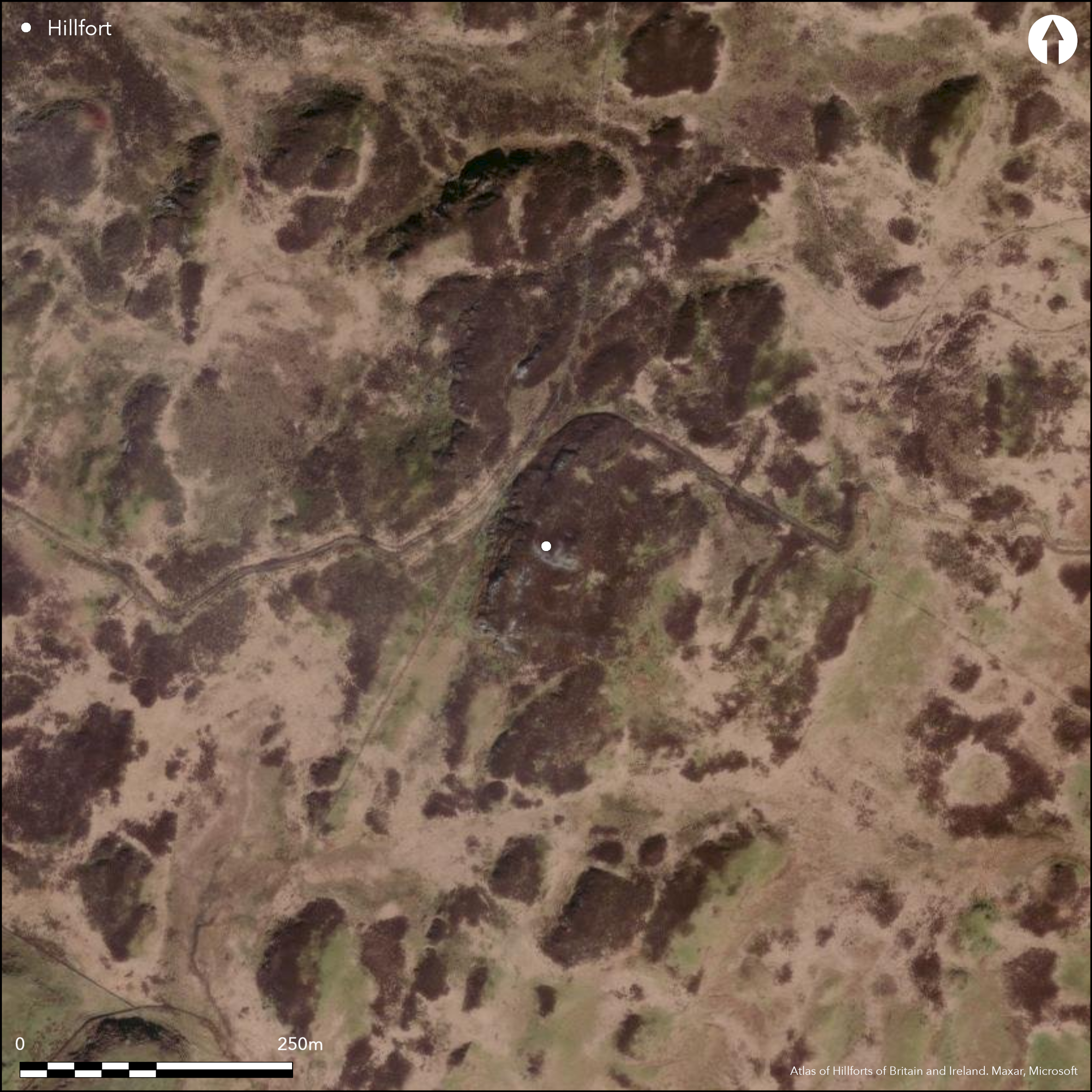
A complex fortification with at least three lines of defence is situated on the summit of Ranachan Hill. The innermost component of the scheme is a pear-shaped enclosure on the very highest part of the summit area and possibly overrides a large circular cairn on the S. This enclosure measures 35m from N to S by a maximum of 24m transversely (0.07ha) within a wall between 2.7m and 3.7m in thickness; long runs of inner and outer facing-stones are visible all round the circuit, in one place standing up to 1.3m in five courses, but there is also evidence of what are either internal revetments or earlier faces within the body of the core, in three places apparently facing inwards, and in one outwards. A well-formed entrance on the W, which expands from 2m wide at the outer end of the passage to 2.7m at the inner, does not have built checks, but two large fallen slabs may have been jamb-stones; there is also a gap in the wall on the N. The walls of the outer enclosures are heavily robbed, the first enclosing a trapezoidal area measuring a maximum of 79m from NE to SW by 60m transversely (0.4ha), and the second springing from the first to take in an additional strip on the SE; the second, which retains extensive runs of outer face, was possibly constructed successively to enclose a larger area of 0.54ha; in addition to a well-defined entrance in the second wall on the SW, there are gaps in the first on the NE, SE and SW, though only that on the NE can be identified as a probable entrance. There are no traces of any contemporary structures within the defences, but three small subrectangular to oval structures built on the line of the wall of the outer enclosure on the NE, together with a fourth standing outside its line on the N indicate a subsequent period of occupation during the medieval or post-medieval period (cf Balloch Hill, Atlas No. 2210). In addition to these enclosures, which appear to use the topography to tactical advantage, there is a fourth line of enclosure surrounding the hilltop. For the most part reduced to little more than a scatter of stones, its full extent is unknown.
Citizen Science: ✗
Reliability of Data: Confirmed
Reliability of Interpretation: Confirmed
X: -629799 Y: 7452470 (EPSG: 3857)
Longitude: -5.657584871364284 Latitude: 55.46412966182823 (EPSG:4326)
Country: Scotland
Current County or Unitary Authority: Argyll & Bute
Historic County: Argyll
Current Parish/Community/Council/Townland: Campbeltown
None
| Extant | ✓ |
| Cropmark | ✗ |
| Likely Destroyed | ✗ |
None
| Woodland | ✗ |
| Commercial Forestry Plantation | ✗ |
| Parkland | ✗ |
| Pasture (Grazing) | ✓ |
| Arable | ✗ |
| Scrub/Bracken | ✗ |
| Bare Outcrop | ✗ |
| Heather/Moorland | ✓ |
| Heath | ✗ |
| Built-up | ✗ |
| Coastal Grassland | ✗ |
| Other | ✗ |
None
| Contour Fort | ✓ |
| Partial Contour Fort | ✗ |
| Promontory Fort | ✗ |
| Hillslope Fort | ✗ |
| Level Terrain Fort | ✗ |
| Marsh Fort | ✗ |
| Multiple Enclosure Fort | ✓ |
| Hilltop | ✓ |
| Coastal Promontory | ✗ |
| Inland Promontory | ✗ |
| Valley Bottom | ✗ |
| Knoll/Hillock/Outcrop | ✗ |
| Ridge | ✗ |
| Cliff/Plateau-edge/Scarp | ✗ |
| Hillslope | ✗ |
| Lowland | ✗ |
| Spur | ✗ |
Dominant Topographic Feature: None
| North | ✗ |
| Northeast | ✗ |
| East | ✗ |
| Southeast | ✗ |
| South | ✗ |
| Southwest | ✗ |
| West | ✗ |
| Northwest | ✗ |
| Level | ✓ |
Altitude: 215.0m
N/A
In the absence of excavation, there are neither stratified artefacts nor radiocarbon dates to provide a chronology for the defences.
Reliability: D - None
| Pre 1200BC | ✗ |
| 1200BC - 800BC | ✗ |
| 800BC - 400BC | ✗ |
| 400BC - AD50 | ✗ |
| AD50 - AD400 | ✗ |
| AD400 - AD 800 | ✗ |
| Post AD800 | ✗ |
| Unknown | ✓ |
| Pre Hillfort: | There is possible an earlier burial cairn |
| Post Hillfort: | The wall is overlain by sub-rectangular huts |
First depicted on the 1st edition OS 25-inch map in 1867 (Argyll and Bute 1869, sheet 251.15), it was first planned during the RCAHMS Survey of Marginal Lands and resurveyed in 1968 for the County Inventory of Argyll (RCAHMS 1971, 74-5, no.173, fig 52). It was Scheduled in 1971 and visited by the OS 1n 1977. RCAHMS photographed it from the air in 2008
| 1st Identified Map Depiction (1867): | Annotated Fort on 1st edition OS 25-inch map (Argyll and Bute 1869, sheet 251.15) |
| Other (1955): | Visited for RCAHMS Marginal Lands |
| Earthwork Survey (1956): | Planned during RCAHMS Marginal Lands (RCAHMS AGD 297/1-3) |
| Earthwork Survey (1965): | Detail of entrance (RCAHMS AGD297/4) |
| Earthwork Survey (1968): | Plan and description (RCAHMS 1971, 74-5, no.173, fig 52; RCAHMS AGD 297/3) |
| Other (1971): | Scheduled |
| Other (1977): | Surveyed at 1:10.000 by the OS |
| Other (2008): | Aerial photography by RCAHMS |
Subrectangular structures overlie the outer enclosure on the NE, but the interior is otherwise featureless
None
| None | ✓ |
| Spring | ✗ |
| Stream | ✗ |
| Pool | ✗ |
| Flush | ✗ |
| Well | ✗ |
| Other | ✗ |
None
| No Known Features | ✗ |
| Round Stone Structures | ✗ |
| Rectangular Stone Structures | ✓ |
| Curvilinear Platforms | ✗ |
| Other Roundhouse Evidence | ✗ |
| Pits | ✗ |
| Quarry Hollows | ✗ |
| Other | ✗ |
None
| No Known Excavation | ✓ |
| Pits | ✗ |
| Postholes | ✗ |
| Roundhouses | ✗ |
| Rectangular Structures | ✗ |
| Roads/Tracks | ✗ |
| Quarry Hollows | ✗ |
| Other | ✗ |
| Nothing Found | ✗ |
None
| No Known Geophysics | ✓ |
| Pits | ✗ |
| Roundhouses | ✗ |
| Rectangular Structures | ✗ |
| Roads/Tracks | ✗ |
| Quarry Hollows | ✗ |
| Other | ✗ |
| Nothing Found | ✗ |
None
| No Known Finds | ✓ |
| Pottery | ✗ |
| Metal | ✗ |
| Metalworking | ✗ |
| Human Bones | ✗ |
| Animal Bones | ✗ |
| Lithics | ✗ |
| Environmental | ✗ |
| Other | ✗ |
NO APPARENT FEATURES
| APs Not Checked | ✗ |
| None | ✓ |
| Roundhouses | ✗ |
| Rectangular Structures | ✗ |
| Pits | ✗ |
| Postholes | ✗ |
| Roads/Tracks | ✗ |
| Other | ✗ |
See main summary
| 6: | In all walls and ramparts |
| 2: | Generally two, both in the innermost enclosure, and the immediately surrounding enclosure, but there is no direct relationship between any of them and there is at least one other gap in the outer enclosure. |
Guard Chambers: ✗
Chevaux de Frise: ✗
| 1. Simple Gap (North): | Inner enclosure |
| 1. Simple Gap (North): | Outer enclosure |
| 2. Simple Gap (West): | Inner enclosure |
| 3. Simple Gap (South east): | Inner wall of the outer enclosure, gully between outcrops |
| 4. Simple Gap (South west): | inner wall of the outer enclosure, robbed gap in likely position |
| 4. Simple Gap (South west): | Outer wall of the outer enclosure |
Series of walled enclosures, of which only the innermost has a complete circuit
| Area 1: | 0.07ha. |
| Area 2: | 0.4ha. |
| Area 3: | 0.54ha. |
| Total: | 0.54ha. |
Total Footprint Area: 0.58ha.
None
| ✗ | The fourth line of enclosure here, which does not appear to be sited tactically and is incompletely known, may take in in excess of 2ha |
| ✓ | The outermost line has been excluded |
| NE Quadrant: | 2 |
| SE Quadrant: | 3 |
| SW Quadrant: | 3 |
| NW Quadrant: | 1 |
| Total: | 3 |
| Partial Univallate | ✓ |
| Univallate | ✗ |
| Partial Bivallate | ✓ |
| Bivallate | ✗ |
| Partial Multivallate | ✓ |
| Multivallate | ✗ |
| Unknown | ✗ |
| Partial Univallate | ✗ |
| Univallate | ✓ |
| Partial Bivallate | ✗ |
| Bivallate | ✗ |
| Partial Multivallate | ✗ |
| Multivallate | ✗ |
Murus duplex or multiperiod
| None | ✗ |
| Earthen Bank | ✗ |
| Stone Wall | ✓ |
| Rubble | ✗ |
| Wall-walk | ✗ |
| Evidence of Timber | ✗ |
| Vitrification | ✗ |
| Other Burning | ✗ |
| Palisade | ✗ |
| Counter Scarp Bank | ✗ |
| Berm | ✗ |
| Unfinished | ✗ |
| Other | ✓ |
None
| None | ✗ |
| Earthen Bank | ✗ |
| Stone Wall | ✗ |
| Murus Duplex | ✗ |
| Timber-framed | ✗ |
| Timber-laced | ✗ |
| Vitrification | ✗ |
| Other Burning | ✗ |
| Palisade | ✗ |
| Counter Scarp Bank | ✗ |
| Berm | ✗ |
| Unfinished | ✗ |
| No Known Excavation | ✓ |
| Other | ✗ |
| ✗ | None |
| ✗ | None |
Number of Ditches: None
| ✗ | None |
RCAHMS (1971) The Royal Commission on the Ancient and Historical Monuments of Scotland. Argyll: an inventory of the ancient monuments, volume 1: Kintyre. HMSO: Edinburgh
Atlas of Hillforts:
Wikidata:
This work is licensed under CC BY-SA 4.0![]()
![]()
![]() and should be cited as:
and should be cited as:
Lock, Gary and Ralston, Ian. 2024. Atlas of Hillforts of Britain and Ireland. Available at: https://hillforts.arch.ox.ac.uk
Document Version 1.1