Satellite Imagery
Satellite Imagery
HER: The West of Scotland Archaeology Service 2961 (None)
NMR: NR 62 NE 13 (38369)
SM: 3063
NGR: NR 6812 2595
X: 168120 Y: 625950 (OSGB36)
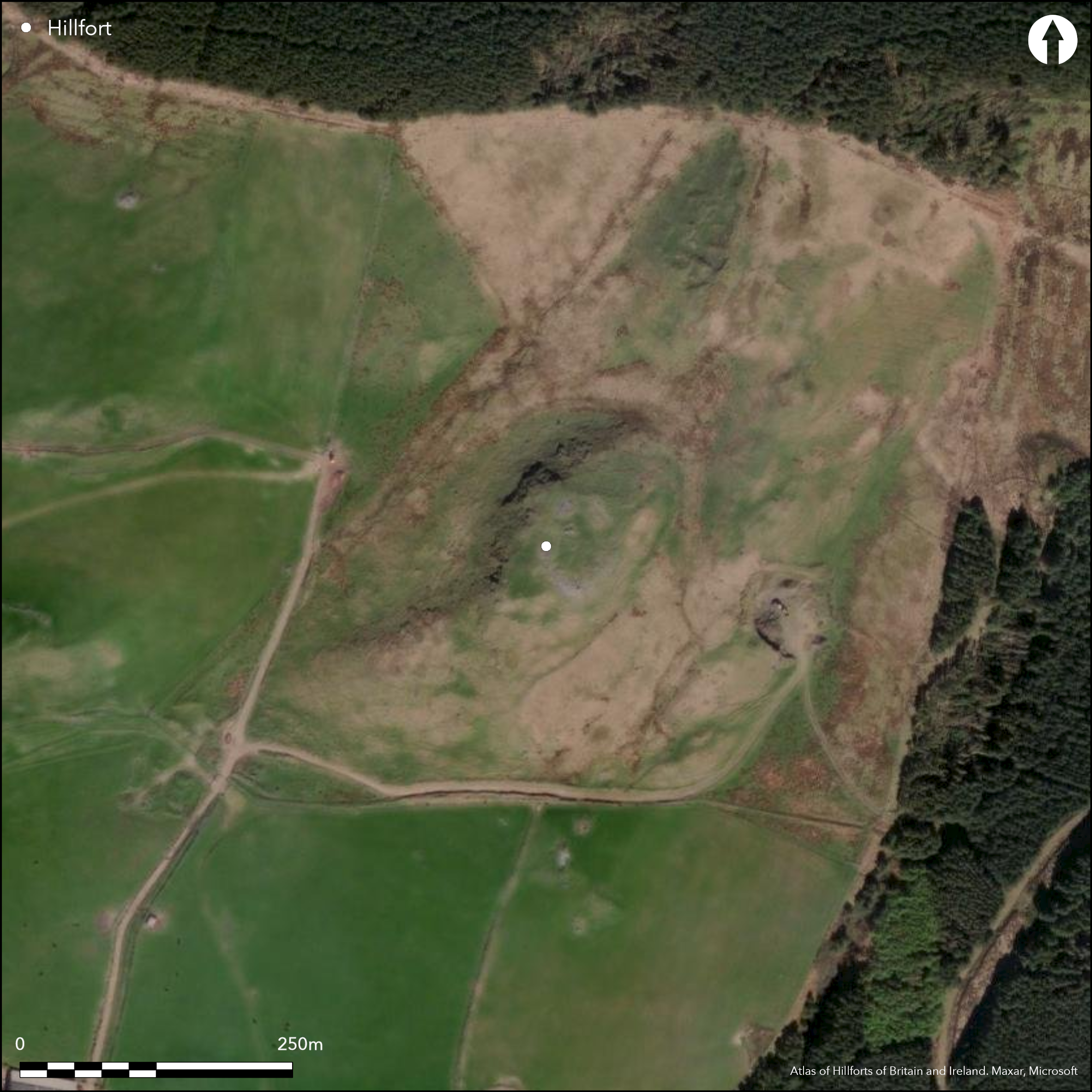
This fort, situated on a prominent spur forming a local summit, comprises two successive elements: an inner walled enclosure, which overlies an outer multivallate perimeter. The inner enclosure is oval on plan and measures 40m from N to S by 33m transversely (0.1ha) within a wall between 2.4m and 4.3m in thickness; numerous runs of inner and outer face are visible and a gap on the E probably marks the entrance. The earlier multivallate fort is irregular on plan, measuring a maximum of 83m from NE to SW by 49m transversely (0.3ha) within the innermost rampart, now reduced to little more than an a scarp. A second heavily-robbed rampart pursues an eccentric course at the foot of the slope below on the S, E and NE, and a third on the E and NE, but while both have been reduced to scarps, they also retain several long runs of outer face. A modern track on the NE may mark the position of the original entrance. No contemporary structures can be seen within either fortification, but three circular platforms lie between the outer ramparts of the earlier fort on the N. A denarius of Trajan minted AD 103-11 found at the beginning of the 20th century 'under the surface in an old fort at Balergie' (Robertson 1950, 141), may come from here.
Citizen Science: ✗
Reliability of Data: Confirmed
Reliability of Interpretation: Confirmed
X: -631241 Y: 7454072 (EPSG: 3857)
Longitude: -5.670530342905061 Latitude: 55.4722843048209 (EPSG:4326)
Country: Scotland
Current County or Unitary Authority: Argyll & Bute
Historic County: Argyll
Current Parish/Community/Council/Townland: Killean And Kilchenzie
None
| Extant | ✓ |
| Cropmark | ✗ |
| Likely Destroyed | ✗ |
None
| Woodland | ✗ |
| Commercial Forestry Plantation | ✗ |
| Parkland | ✗ |
| Pasture (Grazing) | ✓ |
| Arable | ✗ |
| Scrub/Bracken | ✗ |
| Bare Outcrop | ✗ |
| Heather/Moorland | ✓ |
| Heath | ✗ |
| Built-up | ✗ |
| Coastal Grassland | ✗ |
| Other | ✗ |
None
| Contour Fort | ✓ |
| Partial Contour Fort | ✗ |
| Promontory Fort | ✗ |
| Hillslope Fort | ✗ |
| Level Terrain Fort | ✗ |
| Marsh Fort | ✗ |
| Multiple Enclosure Fort | ✓ |
| Hilltop | ✓ |
| Coastal Promontory | ✗ |
| Inland Promontory | ✗ |
| Valley Bottom | ✗ |
| Knoll/Hillock/Outcrop | ✗ |
| Ridge | ✗ |
| Cliff/Plateau-edge/Scarp | ✗ |
| Hillslope | ✗ |
| Lowland | ✗ |
| Spur | ✗ |
Dominant Topographic Feature: None
| North | ✗ |
| Northeast | ✗ |
| East | ✗ |
| Southeast | ✗ |
| South | ✗ |
| Southwest | ✗ |
| West | ✗ |
| Northwest | ✗ |
| Level | ✓ |
Altitude: 160.0m
N/A
A denarius from Trajan may have been found here, but from an unknown context
Reliability: D - None
| Pre 1200BC | ✗ |
| 1200BC - 800BC | ✗ |
| 800BC - 400BC | ✗ |
| 400BC - AD50 | ✗ |
| AD50 - AD400 | ✓ |
| AD400 - AD 800 | ✗ |
| Post AD800 | ✗ |
| Unknown | ✓ |
| Pre Hillfort: | None |
| Post Hillfort: | Possible round-hose platforms are not contemporary with the defences; there is also a post medieval built across the interior of the later fort. |
| Artefactual: | None |
None
| 1st Identified Map Depiction (1867): | Annotated Fort on 1st edition OS 25-inh map (Argyll and Bute 1869, sheet 251.10) |
| Other (1943): | Description and photo taken during RCAHMS wartime Emergency Surveys |
| Other (1955): | Visited during RCAHMS Survey of Marginal Lands |
| Earthwork Survey (1956): | Plan and description RCAHMS Survey of Marginal Lands (RCAHMS AGD 295/1-2) |
| Other (1965): | Description (RCAHMS 1971, 73-4, no.171) |
| Other (1971): | Scheduled |
| Other (1977): | Surveyed at 1:10.000 by the OS |
| Other (2008): | Photographed from the air by RCAHMS |
Featureless, though three possible round-house platforms overlie the defences of the multivallate fort on the N
None
| None | ✓ |
| Spring | ✗ |
| Stream | ✗ |
| Pool | ✗ |
| Flush | ✗ |
| Well | ✗ |
| Other | ✗ |
three possible round-house platforms overlie the defences of the multivallate fort on the N
| No Known Features | ✗ |
| Round Stone Structures | ✗ |
| Rectangular Stone Structures | ✗ |
| Curvilinear Platforms | ✓ |
| Other Roundhouse Evidence | ✗ |
| Pits | ✗ |
| Quarry Hollows | ✗ |
| Other | ✗ |
None
| No Known Excavation | ✓ |
| Pits | ✗ |
| Postholes | ✗ |
| Roundhouses | ✗ |
| Rectangular Structures | ✗ |
| Roads/Tracks | ✗ |
| Quarry Hollows | ✗ |
| Other | ✗ |
| Nothing Found | ✗ |
None
| No Known Geophysics | ✓ |
| Pits | ✗ |
| Roundhouses | ✗ |
| Rectangular Structures | ✗ |
| Roads/Tracks | ✗ |
| Quarry Hollows | ✗ |
| Other | ✗ |
| Nothing Found | ✗ |
A denarius of Trajan minted AD 103-11 found at the beginning of the 20th century 'under the surface in an old fort at Balergie' (Robertson 1950, 141), may come from here
| No Known Finds | ✓ |
| Pottery | ✗ |
| Metal | ✗ |
| Metalworking | ✗ |
| Human Bones | ✗ |
| Animal Bones | ✗ |
| Lithics | ✗ |
| Environmental | ✗ |
| Other | ✗ |
NO APPARENT FEATURES
| APs Not Checked | ✗ |
| None | ✓ |
| Roundhouses | ✗ |
| Rectangular Structures | ✗ |
| Pits | ✗ |
| Postholes | ✗ |
| Roads/Tracks | ✗ |
| Other | ✗ |
See main summary
| 1: | Numerous gaps in the outer defences |
| 2: | In two phases of defence |
Guard Chambers: ✗
Chevaux de Frise: ✗
| 1. Simple Gap (East): | Later fort |
| 1. Simple Gap (North east): | Earlier outer defences |
Complete inner circuits in two phases partial multivallation on one side
| Area 1: | 0.1ha. |
| Area 2: | 0.3ha. |
| Total: | 0.3ha. |
Total Footprint Area: 0.68ha.
None
| ✓ | None |
| ✓ | None |
| NE Quadrant: | 4 |
| SE Quadrant: | 3 |
| SW Quadrant: | 2 |
| NW Quadrant: | 2 |
| Total: | 4 |
| Partial Univallate | ✗ |
| Univallate | ✗ |
| Partial Bivallate | ✓ |
| Bivallate | ✗ |
| Partial Multivallate | ✓ |
| Multivallate | ✗ |
| Unknown | ✗ |
| Partial Univallate | ✗ |
| Univallate | ✓ |
| Partial Bivallate | ✗ |
| Bivallate | ✗ |
| Partial Multivallate | ✗ |
| Multivallate | ✗ |
None
| None | ✗ |
| Earthen Bank | ✗ |
| Stone Wall | ✓ |
| Rubble | ✓ |
| Wall-walk | ✗ |
| Evidence of Timber | ✗ |
| Vitrification | ✗ |
| Other Burning | ✗ |
| Palisade | ✗ |
| Counter Scarp Bank | ✗ |
| Berm | ✗ |
| Unfinished | ✗ |
| Other | ✗ |
None
| None | ✗ |
| Earthen Bank | ✗ |
| Stone Wall | ✗ |
| Murus Duplex | ✗ |
| Timber-framed | ✗ |
| Timber-laced | ✗ |
| Vitrification | ✗ |
| Other Burning | ✗ |
| Palisade | ✗ |
| Counter Scarp Bank | ✗ |
| Berm | ✗ |
| Unfinished | ✗ |
| No Known Excavation | ✓ |
| Other | ✗ |
| ✗ | None |
| ✗ | None |
Number of Ditches: None
| ✗ | None |
RCAHMS (1971) The Royal Commission on the Ancient and Historical Monuments of Scotland. Argyll: an inventory of the ancient monuments, volume 1: Kintyre. HMSO: Edinburgh
Robertson, A S (1950) 'Roman Coins found in Scotland'. Proc Soc Antiq Scot 84 (1949-50), 137-69
Atlas of Hillforts:
Wikidata:
This work is licensed under CC BY-SA 4.0![]()
![]()
![]() and should be cited as:
and should be cited as:
Lock, Gary and Ralston, Ian. 2024. Atlas of Hillforts of Britain and Ireland. Available at: https://hillforts.arch.ox.ac.uk
Document Version 1.1